Open-File Report 2014–1018
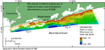
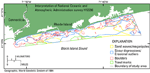
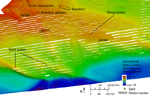
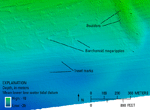
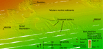
Water depths in the study area range from about 2 m close to shore to about 33 m along the southern side of the area (fig. 11). Several sea-floor features are visible in the MBES data including boulders, sand waves, scour depressions, modern marine sediments, and trawl marks (fig. 12). These features often overlap, and boundaries are gradational. Boulders occur in patches, mostly within shallow depths less than 20 m (figs. 13, 14, and 15). They are generally several meters wide and a couple of meters high, but they can reach over 10 m in width. The boulders are lag deposits of winnowed, ice-proximal glacial drift, deposited during the northward retreat of the Laurentide Ice Sheet, some time before the Harbor Hill-Roanoke Point-Charlestown-Buzzards Bay end moraine was constructed, about 18,000 to 23,000 years ago (Uchupi and others, 2001; Balco, 2011). Exposed boulders indicate modern high-energy environments where processes of erosion and nondeposition are prevalent. In general, sand waves within the study area tend to have crests that are oriented perpendicular to shore, and wavelengths of several hundred meters. Megaripples occur with crests that are oriented either parallel or perpendicular to shore, have much smaller wavelengths (from about 20 to 50 m), and are observed either alone or concurrently with the larger sand waves. Two areas of megaripples in the western part of the study area, have east-west oriented crests with wavelengths from about 20 to 40 m and wave heights from 20 to 30 cm. The southern-most of these two areas also has sand waves with northwest-southeast oriented crests, 500-m wavelengths, and 1- to 2-m heights. In the western part of the study area there is a section of barchanoid megaripples that have horns pointing to the east, which indicates eastward sediment transport (fig. 14; McKee, 1966). A large area of sand waves and megaripples in the east-central part of the study area consists of megaripples with north-south oriented crests and about 20- to 90-m wavelengths, superimposed on northwest-southeast oriented sand waves with about 500-m wavelengths and 2-m heights (fig. 13). Further to the east are megaripples with northwest-southeast oriented crests, several-hundred-meter wavelengths, and 0.5- to 1-m heights. The northwest-southeast oriented sand waves and megaripples in the study area reflect bedload transport associated with shore-parallel, tidally driven, and wind-driven currents in this area (White and White, 2012). It is likely that megaripples with crests that are oriented parallel to shore, reflect sediment reworking and transport that is associated with wind-driven waves, and, in deep water, with storm waves. Sand waves and megaripples commonly grade into nearby scour depressions and boulders. Scour depressions occur throughout much of the study area, and are characterized by 20- to 50-cm deep indentations with steep sides, and coarser grained sediment on the floor of the depression than on the surrounding sea floor (fig. 15). These are common features within Block Island and Rhode Island Sounds (McMullen and others, 2007, 2011, 2012, 2013; Poppe and others, 2011, 2012) and are also called cross-shore swaths (Oakley and others, 2009; Boothroyd, 2009). Oakley and others (2009) describe cross-shore swaths near the Rhode Island shoreline as areas formed from the down welling of seaward flowing water during storms. Morang and McMaster (1980) believed these features were formed from rip currents, waves, and (or) storm-generated flows. Scour depressions are thought to be maintained because their coarse-grained floors create turbulence in bottom water, which scours finer material and prevents it from being deposited in these areas (Murray and Thieler, 2004). Thus, scour depressions indicate high-energy, sedimentary environments of erosion and nondeposition. Scour depressions in the study area are surrounded by modern marine sediments, and often contain erosional outliers of these undisturbed, featureless, sandy sediments within the depressions. |

![]() U.S. Department of the Interior |
U.S. Geological Survey
U.S. Department of the Interior |
U.S. Geological Survey
URL: http://pubsdata.usgs.gov/pubs/of/2014/1018/html/bathy.html
Page Contact Information: GS Pubs Web Contact
Page Last Modified: Wednesday, 07-Dec-2016 19:33:50 EST