Open-File Report 2014-1160
![]() Title | List of Figures | Conversion Factors | Abstract | Introduction | Setting | Methods | Bathymetry | Sediments | Bottom Photography | GIS Data Catalog | Summary | Acknowledgments | References Cited | Contacts |
Index
Title | List of Figures | Conversion Factors | Abstract | Introduction | Setting | Methods | Bathymetry | Sediments | Bottom Photography | GIS Data Catalog | Summary | Acknowledgments | References Cited | Contacts |
Index
 |
||
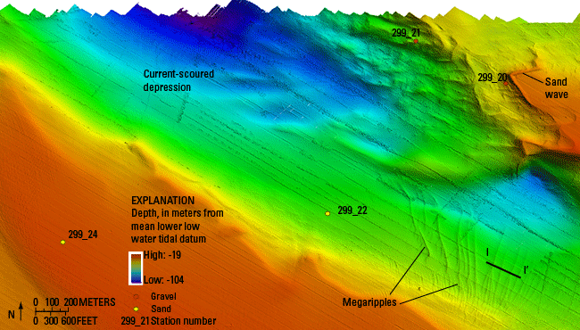
Figure 18. Detailed bathymetric image of the tidal-current-scoured bathymetric depression in the northwestern part of the study area, in the vicinity of The Race. The eastern side of the scour depression is rugged, with a gravel pavement on the sea floor, whereas the southern and western sides are sandy and more gradually sloped. Megaripples and sand waves, probably formed from excavated sediments, are visible on the eastern and southern sides of the scour depression. Locations of several sediment samples and their grain sizes and sand-wave profile I-I’ are also shown. Location of image is shown in figure 12. |
||

![]() U.S. Department of the Interior |
U.S. Geological Survey
U.S. Department of the Interior |
U.S. Geological Survey
URL: http://pubsdata.usgs.gov/pubs/of/2014/1160/html/ofr2014-1160-fig18.html
Page Contact Information: GS Pubs Web Contact
Page Last Modified: Wednesday, 07-Dec-2016 19:37:42 EST
