Open-File Report 2014-1160
![]() Title | List of Figures | Conversion Factors | Abstract | Introduction | Setting | Methods | Bathymetry | Sediments | Bottom Photography | GIS Data Catalog | Summary | Acknowledgments | References Cited | Contacts |
Index
Title | List of Figures | Conversion Factors | Abstract | Introduction | Setting | Methods | Bathymetry | Sediments | Bottom Photography | GIS Data Catalog | Summary | Acknowledgments | References Cited | Contacts |
Index
 |
||
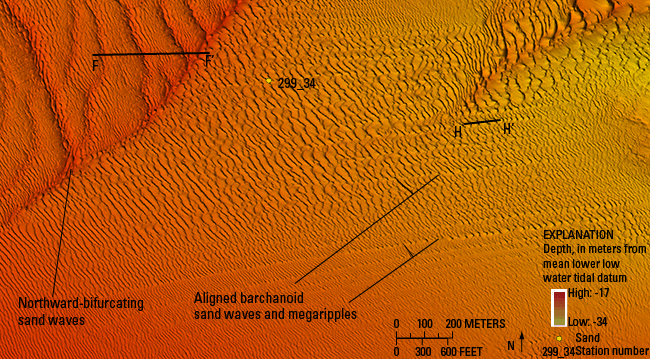
Figure 20. Detailed bathymetric image of aligned barchanoid sand waves and megaripples to the southeast of the northward-bifurcating transverse sand waves. The barchanoid waves are aligned such that waves form parallel lines normal to the axes of their crests. Their horns tend to merge with those of nearby sand waves and indicate net westward sediment transport. Locations of a sediment sample and sand-wave profiles F-F’ and H-H’ are also shown. Location of image is shown in figure 12. | ||

![]() U.S. Department of the Interior |
U.S. Geological Survey
U.S. Department of the Interior |
U.S. Geological Survey
URL: http://pubsdata.usgs.gov/pubs/of/2014/1160/html/ofr2014-1160-fig20.html
Page Contact Information: GS Pubs Web Contact
Page Last Modified: Wednesday, 07-Dec-2016 19:37:44 EST
