Data in this report are available as downloadable files based on four geographic regions that comprise the northern Alaska study area. The index maps (figs. 1–4) highlight areas of shoreline coverage in brown (exposed open-ocean coasts) and orange (sheltered mainland-lagoon coasts) for the four regions. All vector data are delivered as ESRI shapefiles in the geographic coordinate system (WGS84) and distributed with extensible markup language (*.xml) format metadata generated by ArcCatalog™ and Federal Geographic Data Committee (FGDC) compliant metadata files. Tabular data are delivered as dBase IV (*.dbf) structured files, which can be read with ArcGIS™ software as well as many other available spreadsheet programs. Metadata also are provided for all spatial and tabular data in FGDC text (*.txt) and FGDC Classic (*.html) format. This report includes all files necessary to perform shoreline change analyses using the Digital Shoreline Analysis System (DSAS) software. Please refer to Thieler and others (2009) for information about the DSAS software application that was used to calculate the rates, which are discussed at length in the full report on the National Assessment of Shoreline Change for the north coast of Alaska (Gibbs and Richmond, 2015).
The following files are available for download for each of the four geographic regions (see index maps):
Data layers can be downloaded individually from the following table. Individual layers are provided as compressed *.zip files.
North Coast of Alaska (U.S.-Canadian Border to Icy Cape) |
File |
Description |
|
|
All_4_Regions.zip |
Download all data for the report |
|
|
East Beaufort Sea (U.S.-Canadian Border to the Okpilak-Hulahula River Delta)
Click on figure for larger image.

Figure 1. Map showing shoreline coverage in the East Beaufort Sea region of the study area, north coast of Alaska.
|
File |
Description |
Metadata |
Download |
EastBeaufort_shorelines.zip |
Download all data for the East Beaufort Sea region |
|
|
EastBeaufort_shorelines.shp |
Compiled shorelines for the eastern Beaufort Sea region |
.html
.txt |
.zip
(522 KB) |
EastBeaufort_exposed_baselines.shp |
Offshore baseline for generating shore-normal transects in DSAS exposed shorelines |
.html
.txt |
.zip
(9 KB) |
EastBeaufort_sheltered_baselines.shp |
Offshore baseline for generating shore-normal transects in DSAS along sheltered shorelines |
.html
.txt |
.zip
(16 KB) |
EastBeaufort_exposed_transects.shp |
Shore-normal transects and associated rate calculations along exposed shorelines |
.html
.txt |
.zip
(188 KB) |
EastBeaufort_sheltered_transects.shp |
Shore-normal transects and associated rate calculations along sheltered shorelines |
.html
.txt |
.zip
(233 KB) |
Central Beaufort Sea (Okpilak-Hulahula River Delta to the Colville River Delta)
Click on figure for larger image.
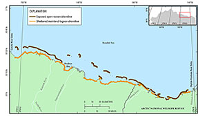
Figure 2. Map showing shoreline coverage in the Central Beaufort Sea region of the study area, north coast of Alaska.
|
File |
Description |
Metadata |
Download |
CentralBeaufort_shorelines.zip |
Download all data for the Central Beaufort Sea region |
|
|
CentralBeaufort_shorelines.shp |
Compiled shorelines for the central Beaufort Sea region |
.html
.txt |
.zip
(925 KB) |
CentralBeaufort_exposed_baselines.shp |
Offshore baseline for generating shore-normal transects in DSAS along exposed shorelines |
.html
.txt |
.zip
(11 KB) |
CentralBeaufort_sheltered_baselines.shp |
Offshore baseline for generating shore-normal transects in DSAS along sheltered shorelines |
.html
.txt |
.zip
(19 KB) |
CentralBeaufort_exposed_transects.shp |
Shore-normal transects and associated rate calculations along exposed shorelines |
.html
.txt |
.zip
(231 KB) |
CentralBeaufort_sheltered_transects.shp |
Shore-normal transects and associated rate calculations along sheltered shorelines |
.html
.txt |
.zip
(341 KB) |
Western Beaufort Sea (Colville River Delta to Point Barrow)
Click on figure for larger image.
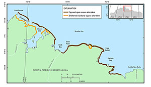
Figure 3. Map showing shoreline coverage in the West Beaufort Sea region of the study area, north coast of Alaska.
|
File |
Description |
Metadata |
Download |
WestBeaufort_shorelines.zip |
Download all data for the Western Beaufort Sea region |
|
|
WestBeaufort_shorelines.shp |
Compiled shorelines for the western Beaufort Sea region |
.html
.txt |
.zip
(456 KB) |
WestBeaufort_exposed_baselines.shp |
Offshore baseline for generating shore-normal transects in DSAS along exposed coast shorelines |
.html
.txt |
.zip
(13 KB) |
WestBeaufort_sheltered_baselines.shp |
Offshore baseline for generating shore-normal transects in DSAS along sheltered shorelines |
.html
.txt |
.zip
(12 KB) |
WestBeaufort_exposed_transects..shp |
Shore-normal transects and associated rate calculations along exposed shorelines |
.html
.txt |
.zip
(366 KB) |
WestBeaufort_sheltered_transects.shp |
Shore-normal transects and associated rate calculations along sheltered shorelines |
.html
.txt |
.zip
(182 KB) |
Eastern Chukchi Sea (Point Barrow to Icy Cape)
Click on figure for larger image.
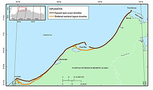
Figure 4. Map showing shoreline coverage in the East Chukchi Sea region of the study area, north coast of Alaska.
|
File |
Description |
Metadata |
Download |
EastChukchi_shorelines.zip |
Download all data for the Eastern Chukchi Sea region |
|
|
EastChukchi_shorelines.shp |
Compiled shorelines for the eastern Chukchi Sea region |
.html
.txt |
.zip
(403 KB) |
EastChukchi_exposed_baselines.shp |
Offshore baseline for generating shore-normal transects in DSAS along exposed shorelines |
.html
.txt |
.zip
(10 KB) |
EastChukchi_sheltered_baselines.shp |
Offshore baseline for generating shore-normal transects in DSAS along sheltered shorelines |
.html
.txt |
.zip
(12 KB) |
EastChukchi_exposed_transects..shp |
Shore-normal transects and associated rate calculations along exposed shorelines |
.html
.txt |
.zip
(380 KB) |
EastChukchi_sheltered_transects.shp |
Shore-normal transects and associated rate calculations along sheltered shorelines |
.html
.txt |
.zip
(194 KB) |

