
Physical Parameters, Grain Size, and Radiochemistry
The table below contains field documentation, sediment characterization data, and imagery available for download for surficial and down-core sedments discussed in this report. Field Activity Collection System (FACS) documents, field logs and auger core logs are available in Portable Document Format (PDF) and can be viewed using the free software Adobe Acrobat Reader (http://get.adobe.com/reader). Collections of x-radiographs of marsh cores; high-resolution auger core photographs; and downcore bulk density, organic matter, grain size, and radiochemical activity graphs can be downloaded as a zipped Joint Photographic Experts Group (JPEG) file. JPEG files can be viewed using standard image viewing software. Spreadsheets and documents in this report were created in Microsoft Office 2010. All spreadsheet data are also available in Comma-Separated Values (CSV) format. Metadata for applicable files are provided in Federal Geographic Data Committee (FGCD) format.
Data Downloads
Surficial Sediment and Sediment Core Data
| Preview | File Description | File Format | Download File | Metadata |
|---|---|---|---|---|
 |
FACS Field logs |
.pdf |
FACS_Spring2014.zip (213 KB) FACS_Fall2014.zip (305 KB) Field Logs_Handwritten_Spring2014.pdf (9.5 MB) Field Logs_Digital_Spring2014.zip (1.5 MB) Field Logs_Handwritten_Fall2014.pdf (24.8 MB) Field Logs_Digital_Fall2014.zip (1.9 MB) |
Not applicable |
 |
Marsh core X-radiographs |
.jpg |
14CTB_Marsh Core Xrays.zip (329 KB) |
Not applicable |
 |
Peat auger core logs |
.pdf |
14CTB_Peat Auger Core Logs.zip (4.1 MB) |
Not applicable |
 |
Peat auger core photographs |
.jpg |
14CTB_Peat Auger Core Photos.zip (24.5 MB) |
Not applicable |
 |
Sample locations Water quality parameters |
Microsoft Excel .csv |
14CTB_Site_Information.zip (34 KB) |
|
 |
Physical parameter data |
Microsoft Excel .csv |
14CTB_Physical_Data.zip (81 KB) |
|
 |
Grain size data |
Microsoft Excel .csv |
14CTB_Grain-Size_Data.zip (431 KB) |
|
 |
Alpha spectroscopy data |
Microsoft Excel .csv |
14CTB_Alpha_Spec_Data.zip (38 KB) |
|
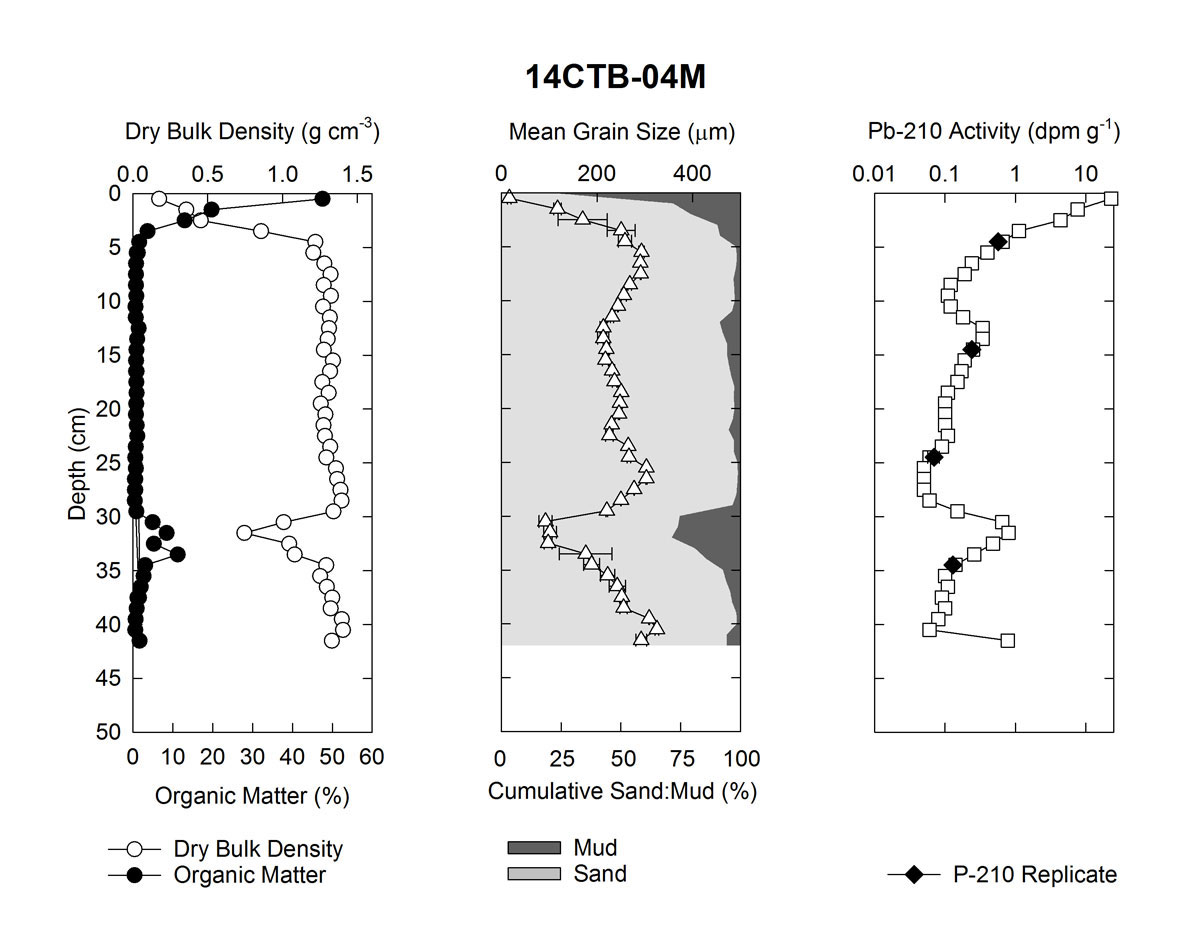 |
Sediment core data plots |
.jpg |
14CTB_Data Plots.zip (776 KB) |
Not applicable |
Supplemental Information
| Preview | File Description | File Format | Download File | Metadata |
|---|---|---|---|---|
 |
Grain size run statistics |
Microsoft Excel .csv |
14CTB_Grain-Size_Run_Statistics.zip (3.68 MB) |
Not applicable |
