Open-File Report 2016-1119
Shallow Geology, Sea-Floor Texture, and Physiographic Zones of Vineyard and Western Nantucket Sounds, Massachusetts
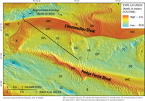
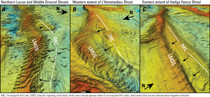
DiscussionSynthesis of Sea-Floor Geologic Maps in Vineyard and western Nantucket SoundsThree of the four primary stratigraphic units (fig. 9) crop out at the sea floor in the study area (fig. 14), and the interpretations of surficial sediment texture (fig. 17) and physiographic zones (fig. 19) are closely related to the distribution of these units. Surficial geologic units may not directly correspond with surficial sediment units because geologic units may be buried beneath surficial sediments too thin to be detected in the seismic data (less than about 0.5 m). Although no sea-floor outcrops of undifferentiated Late Cretaceous(?), Tertiary(?), and (or) early Pleistocene(?) age coastal plain and continental shelf deposits and possibly late Pleistocene (pre-Wisconsinan?) age glacial drift (QTKu?) were interpreted from the geophysical and geologic data, they may exist among late Pleistocene age end moraine (Qdm) outcrops of the Martha’s Vineyard moraine extending southward from the western shore of Martha’s Vineyard (figs. 10, 11, and 14); thrusted and deformed portions of QTKu(?) are known to compose much of the terminal moraine complex along the western margin of Martha’s Vineyard, crop out along the shore in the Aquinnah cliffs, and extend westward beneath the shallow subsurface of Vineyard Sound (Woodsworth and Wigglesworth, 1934; Kaye, 1964a, b; O’Hara and Oldale 1980, 1987; Oldale and O’Hara, 1984). Additional outcrops of Qdm associated with the Buzzards Bay moraine are mapped as a broad swath of sea floor south of Cuttyhunk Island and in narrower zones along the western margin of Vineyard Sound adjacent to the other Elizabeth Islands and in and around Woods Hole. Owing to the presence of abundant boulders and cobble-sized clasts, Qdm outcrops are associated with Rg, Rs, Sr, and Gr surficial sediment textures and rocky physiographic zones (figs. 14, 17, 18, and 19). Late Pleistocene age glacial till and ice contact (Qdt) outcrops are mostly recognized in the central part of the study area across northeastern Vineyard Sound and western Nantucket Sound (fig. 14). Outcrops of Qdt among the western extents of L’Hommedieu and Hedge Fence Shoals and central Middle Ground Shoal are rugged and of moderate relief (figs. 3 and 14). These outcrops contain abundant boulders and cobbles and represent sea-floor exposures of broad ice-contact ridges that are buried by younger sediment in adjacent areas. Qdt also crops out in deeper areas of Vineyard Sound, between Middle Ground and Lucas Shoals and Martha’s Vineyard, and in the channel along its western margin (figs. 3 and 14). Qdt is primarily associated with Rs, Rg, Gr, and Gs surficial sediment textures and rocky or hard-bottom plain physiographic zones (figs. 14, 17, and 19). Late Pleistocene age glaciolacustrine (Qdl) deposits are typically buried by younger units, but sea-floor outcrops are recognized in two locations where overlying deposits have been deeply eroded (fig. 14). One is at the base of an elongate sea-floor depression north of L’Hommedieu Shoal in Nantucket Sound, and the other is in the deep channel between Martha’s Vineyard and Lucas Shoal in eastern Vineyard Sound. The Qdl outcrops are associated with Sm and Sg sediment types (figs. 14 and 17). Both exposures are low relief and exist among adjacent exposures of mostly gravelly and sandy-gravel bottom types within hard-bottom plain physiographic zones (figs. 14, 19). Late Pleistocene age glaciofluvial (Qdf) deposits crop out over much of the sea floor where they are not buried by postglacial deposits (fig. 14). Broad exposures of Qdf dominate the low-lying areas of Vineyard Sound north of Lucas and Middle Ground Shoals, and Nantucket Sound in between Squash Meadow, Hedge Fence, and L’Hommedieu Shoals. Qdf is primarily associated with the G, Gs, Sg, and S surficial sediment types and the hard-bottom plain and nearshore basin physiographic zones (figs. 14, 17, and 19). Holocene age fluvial and estuarine (Qfe) outcrops are generally exposed in sublinear to sinuous patterns among adjacent outcrops of Qdf or Qdt (fig. 14), owing to the origins of Qfe as fluvial and estuarine fill of proglacial fluvial channels. The broadest exposures exist within the main channel along the western margin of Vineyard Sound. Qfe is primarily associated with the G, Gs, Sg, S, and Sm surficial sediment types and the hard-bottom plain and nearshore basin physiographic zones (figs. 14, 17, and 19). Holocene age nearshore and deepwater marine (Qmn and Qmd, respectively) units overlie portions of each of the other units throughout the study area and are composed of fine-grained sediments that have been reworked from the older underlying units. Qmn units are primarily sandy, coinciding with S, Sg, and Gs surficial sediment types (figs. 14 and 17). They form the sandy inner shelf areas of nearshore basin and nearshore ramp zones, the modern mobile bedforms of ebb-tidal delta, nearshore basins, and shoal/sand wave zones, and the beaches characteristic of coastal embayment zones (figs. 14 and 19). Qmd is considerably finer grained than Qmn, associated with Ms, Sm, and S surficial sediment types, and generally restricted to the deeper-water outer basin zone seaward of the mouth of Vineyard Sound (figs. 3, 14, 17, and 19). Geologic FrameworkThese dense, high-resolution data and mapping products refine our understanding of the shallow geologic framework beneath Vineyard and Nantucket Sounds and foster new insights regarding regional depositional history and the relations between near surface geologic units and sea-floor morphology and composition. Glacial RecessionUntil recently, the history of late Wisconsinan age glacial recession from the region was loosely constrained by the trends of the Martha’s Vineyard and Buzzards Bay end moraines and an inferred ice-margin position underlying the southern coast of western Cape Cod (fig. 2). On the basis of data and mapping products equivalent to those presented here, Foster and others (2015) describe how high-resolution mapping of the stratified glacial drift beneath Buzzards Bay reveals evidence of stepwise recession of the Buzzards Bay ice lobe northwestward from the Buzzards Bay moraine (fig. 2). The recessional stratigraphy is characterized by a series of northward-progressing, coarse-drift ridges indicative of ice-proximal deposition at locations where the ice margin was temporarily stable during the overall retreat. Proglacial lacustrine, deltaic, and fluvial outwash units grade generally southward between the inferred ice-marginal deposits, filling basins that were dammed by the previously deposited drift ridge. A meltwater drainage network on the late Wisconsinan age regressive unconformity (Ur), with multiple channels that align with outlets that cut through the drift ridge sills, illustrates the development of successive meltwater channels with trends adjacent to the retreating ice margin. Our mapping of the stratified glacial deposits beneath Vineyard and western Nantucket Sounds provides similar evidence of earlier stepwise north-to-northwestward retreat of the Cape Cod Bay and Buzzards Bay ice lobes from the Martha’s Vineyard end moraine (fig. 2). The coarse-grained, poorly sorted ice-contact and ice-proximal drift deposits (Qdt and parts of Qdf) that form the submerged morainal ridges (figs. 10, 11, 14, and 17) and cores of the major tidal shoals (figs. 3, 12, 13, and 15) identify locations where the ice-margin was temporarily stable during glacial retreat across the Sounds. Smith (1969) was the first to recognize one of the mid-sound, ice-marginal drift ridge features, concluding that Lucas Shoal actually consists of a recessional moraine core partially covered and flanked by a sandy Holocene veneer and elongate spit (Middle Ground Shoal). The linear to sinuous topographic highs of the ice-marginal ridges on the Ur surface (fig. 15) generally parallel the trends of the adjacent end moraines, and each ridge appears to have inherited the distinctive interlobate morphology of the ice margin (fig. 2). The lacustrine, deltaic, and fluvial (Qdl and Qdf) outwash deposits that grade southward from the ice-marginal ridges indicate considerably different deglacial depositional environments across the sounds. Lacustrine deposition, similar to that in Buzzards Bay, occurred in western Vineyard Sound (figs. 10, 11, and 13), probably within two basins dammed by ice-marginal drift that form the Martha’s Vineyard end moraine and the core of Lucas Shoal (fig. 15). The basin fill consists of fine-grained lake-bottom deposits buried by variably thick deltaic and fluvial outwash (fig. 13). In contrast, meltwater deposits across northern Vineyard and western Nantucket Sounds consist mostly of relatively narrow, terraced outwash plains that thinly drape underlying coarse-grained drift between the ice-marginal cores of Squash Meadow, Hedge Fence, and L’Hommedieu Shoals (figs. 1, 12, 13, 15, and 21). Finer grained lacustrine deposits are less extensive and restricted to relatively small and truncated, ponded fills. Notable exceptions are the fine-grained drift impounded in the deeply incised channels identified by O’Hara and Oldale (1987) beneath Nantucket Sound (fig 13, and fig. 4 of O'Hara and Oldale, 1987), but since these units are regionally truncated and trend beneath and oblique to (northeast-southwest) the trends of the mid-sound ice-marginal ridges, it is reasonable to suspect that they were emplaced prior to the late Wisconsinan recession. The network of incised channels and outlets that cut through the ice-marginal sills on the Ur surface (fig. 15) also illustrates the evolution of meltwater drainage adjacent to the retreating glacial margin across the sounds. The earliest drainage developed between the Martha’s Vineyard end moraine and the ice-marginal cores underlying Lucas, Middle Ground, and Squash Meadow Shoals (figs. 1, 3, and 15). The trend was southwestward in Vineyard Sound, likely through the easternmost outlet cut through the submerged extension of the Martha’s Vineyard end moraine between Aquinnah and Cuttyhunk (figs. 10, 11, 13, and 15), and southeastward in Nantucket Sound toward an inferred outlet in the terminal moraine beneath Muskeget Channel, between Martha’s Vineyard and Nantucket (figs. 2 and 15). Progressively younger drainage developed adjacent to the successive ice-marginal ridges, and drainage continued to be divided at locations generally north of the apex of the Martha’s Vineyard moraine, roughly centered on Vineyard Haven (figs. 1 and 15), which also illustrates the sustained influence of the interlobate ice-marginal morphology. Across Vineyard Sound the drainage coursed southwestward through both of the sinuous main channels that traverse its northern and southern margins, passing through outlets cut through the cores of Lucas and Middle Ground Shoals (fig. 15), and the Martha’s Vineyard end moraine sill (figs. 10, 11, 13, and 15). The dominant trend of drainage in western Nantucket Sound was southeastward, flowing laterally behind the north-facing slopes of the ice-margin cores of Squash Meadow, Hedge Fence, and L'Hommedieu Shoals, passing through outlets cut through the ridge cores, flowing across the adjacent outwash plains (fig. 15), and eventually exiting through the inferred outlet through the end moraine beneath Muskeget Channel (figs. 2 and 15). The youngest Pleistocene drainage morphologies are offshore extensions of the groundwater sapping valleys described by Uchupi and Oldale (1994), which served as subsurface conduits for meltwater seepage from glacial lake Cape Cod Bay southward through the Mashpee Pitted Plain into Nantucket Sound (figs. 1 and 15). Upon entering Nantucket Sound this drainage was divided along the ice-marginal core of L’Hommedieu Shoal and forced to pass through the outlet breaches cut through its eastern or western margin toward Vineyard or Nantucket Sounds, respectively (figs. 15 and 21). Holocene Depositional SettingPostglacial sediments are relatively thick within the meltwater drainage valleys beneath western Vineyard Sound, across the deepwater basin southwest of the mouth of Vineyard Sound, and within constructional sand shoals associated mostly with the mid-sound ice-marginal drift ridges (figs. 3, 15, and 16), but elsewhere these sediments thinly cover the postglacial landscape or are absent across much of the sea floor (fig. 16). Broad scale comparison between the regressive unconformity (Ur) surface (fig. 15) and the composite bathymetric DEM (fig. 3) shows that many of the prominent topographic morphologies on the glacial-drift surface, including high-relief bouldery moraines and ice-contact deposits, moderate-relief ice-marginal drift ridges, relatively low-relief outwash plains, and linear to sinuous meltwater drainage channels, are discernable in the present bathymetry. Strong spatial correlation of these glacial morphologies (fig. 15) with zones of high acoustic backscatter (fig. 4) and relatively coarse sea-floor sediment texture (fig. 17) illustrate how exposure or shallow burial of the glacial drift amid the discontinuous cover of finer-grained postglacial sediments (fig. 16) results in the highly variable composition and texture of the sea floor. These geologic framework observations indicate that the topography of the deglacial terrain has exerted a primary influence over patterns of deposition and erosion as Holocene sea level has risen across the sounds. Fluvial deposition, which was narrowly restricted to the incised valleys early during the marine transgression, gradually transitioned to broader estuarine, nearshore, and marine deposition as the sounds became increasingly inundated. The morphology of the postglacial terrain likely partitioned flow as it was gradually inundated; currents within the deeper areas were channeled between the adjacent end moraines and the ice-marginal drift ridges, which likely stood in relief as mid-sound islands during part of the transgression. While waves and tidal currents have reworked the glacial drift deposits, the morphologies of the deglacial terrain have likely been substantially subdued as the Holocene morphologies have evolved. The present depositional environment appears to predominantly consist of reworking and redistribution of glacial and postglacial deposits by waves and tidal currents, while fine-grained marine deposition is restricted to areas along the shorelines, the mid-sound shoals, and less energetic deeper water areas. Smith (1969) hypothesized that reworking and redistribution of the Lucas Shoal ice-marginal drift ridge core from the time it stood as a mid-sound island through its submergence, primarily by southwest waves and alongshore currents, eventually resulted in the blunt western edge of overlying Lucas Shoal and the northeast-trending spit-like extension of Middle Ground Shoal (figs. 1 and 3). Smith (1969) also surmised that these features were continually reworked after submergence until eventually reaching a rough dynamic equilibrium with tidal currents. The new mapping data support Smith’s (1969) model and suggest that the other mid-sound, ice-marginal drift ridges and their associated shoals have evolved similarly. The morphologies of the variably thick Holocene sand shoals and their nonuniform distributions across the underlying ice-marginal drift cores provide evidence of their coevolution as sea-floor deposits reworked and redistributed in the presence of local hydrodynamic conditions during the marine transgression. Sand waves and rippled bedforms superimposed on the shoals clearly indicate that the shoals reside along the boundaries of bidirectional tidal currents, as their asymmetry on either side of the shoal crests indicates opposite directions of sediment transport (figs. 3, 21, and 22). Strong tidal currents have driven the shoal accumulation and maintained the general morphologies of the shoals over time (Smith, 1969). In places, the shoals have accumulated directly above the ice-marginal cores and aligned with their trends, but along parts of each shoal, the sandy sediments have been preferentially transported obliquely across the underlying cores and accumulated in drifts along the flanks of the shoals downdrift of the dominant current direction (figs. 3, 4, 12, 16, and 21). This larger scale skewness of the shoal accumulation, relative to the trends of the underlying ice-marginal cores, is probably indicative of long-term tidal current asymmetries and has resulted in the formation of spit extensions in some instances, as in the relation between Middle Ground and Lucas Shoals described by Smith (1969), or where migration of shoals away from the drift cores has been sufficient to leave the latter either partially or completely exposed on the adjacent sea floor (fig. 22). Low-lying areas of the sounds between the shoals and ice-marginal cores are dominated by nondeposition and erosion. Strong tidal currents generally prevent fine-grained deposition and in places have eroded glacial and postglacial deposits exposed on the sea floor. The spatial configurations of the ice-marginal drift cores and shoals appear to have influenced the degree of erosion by providing shelter from the impacts of waves and tidal currents in some locations and accentuating them in others. For instance, deglacial morphologic features are well preserved on the sea floor of Nantucket Sound between L’Hommedieu and Hedge Fence Shoals, each of which intersects a significant ice-contact mass at its western margin (figs. 3 and 21). The partial enclosure appears to have provided a somewhat protected zone, in which the effects of waves and currents have been reduced over the course of marine transgression. In contrast, the adjacent sea floor within the main passage of the seaway, between the trends of Lucas, Middle Ground, and Squash Meadow Shoals and the Buzzards Bay moraine and L’Hommedieu and Hedge Fence Shoals, is characterized by high backscatter, longitudinal scour marks, and low-relief barchanoid bedforms (figs. 3, 4, and 21). These morphologies suggest relatively thorough reworking of the seabed in the presence of relatively intense tidal current flow that becomes constricted through the narrowest passage through the head of the sounds. Moderate postglacial marine deposition has occurred across western Vineyard Sound and seaward of its mouth. This is due, presumably, to the location in relatively deep water amid the transitional zone between constricted tidal flows farther up the sound and more open ocean hydrodynamic conditions to the southwest (figs 1, 3, and 16). The largest sandy deposit in the sounds not associated with one of the mid-sound ice-marginal drift ridges is in this area at the confluence of tidal currents that flow down the western margin of Vineyard Sound and southward through Quicks Hole from adjacent Buzzards Bay (figs. 1, 3, and 16). This location and the elongate southeast-northwest delta-like areal morphology of the sand body make it reasonable to assume it is at least partially composed of sediments eroded and transported from updrift locations across the main passage of the seaway, and possibly nearby locations within adjacent Buzzards Bay. Additional surficial sand bodies along the southward margin of the Menemsha Bight and south of the Martha’s Vineyard morainal sill (figs. 1, 3, and 16) probably represent similar local depocenters aligned with tidal flow along the eastern margin of Vineyard Sound. The large sand waves superimposed on these depositional features are aligned generally perpendicular to the trend of the tidal flow, and in many instances these sand waves display symmetric cross sections indicative of roughly equivalent and opposite ebb and flood currents through the main passages near the western margin of the sound. The fine-grained blanket of muddy marine sediments beyond the mouth of Vineyard Sound illustrates the diminished influence of the focused tidal flow and increased fine-grained deposition in the open marine setting. |

![]() U.S. Department of the Interior |
U.S. Geological Survey
U.S. Department of the Interior |
U.S. Geological Survey
URL: http://pubsdata.usgs.gov/pubs/of/2016/1119/ofr20161119_discussion.html
Page Contact Information: GS Pubs Web Contact
Page Last Modified: Wednesday, 11-Oct-2017 17:56:21 EDT