FISC - St. Petersburg
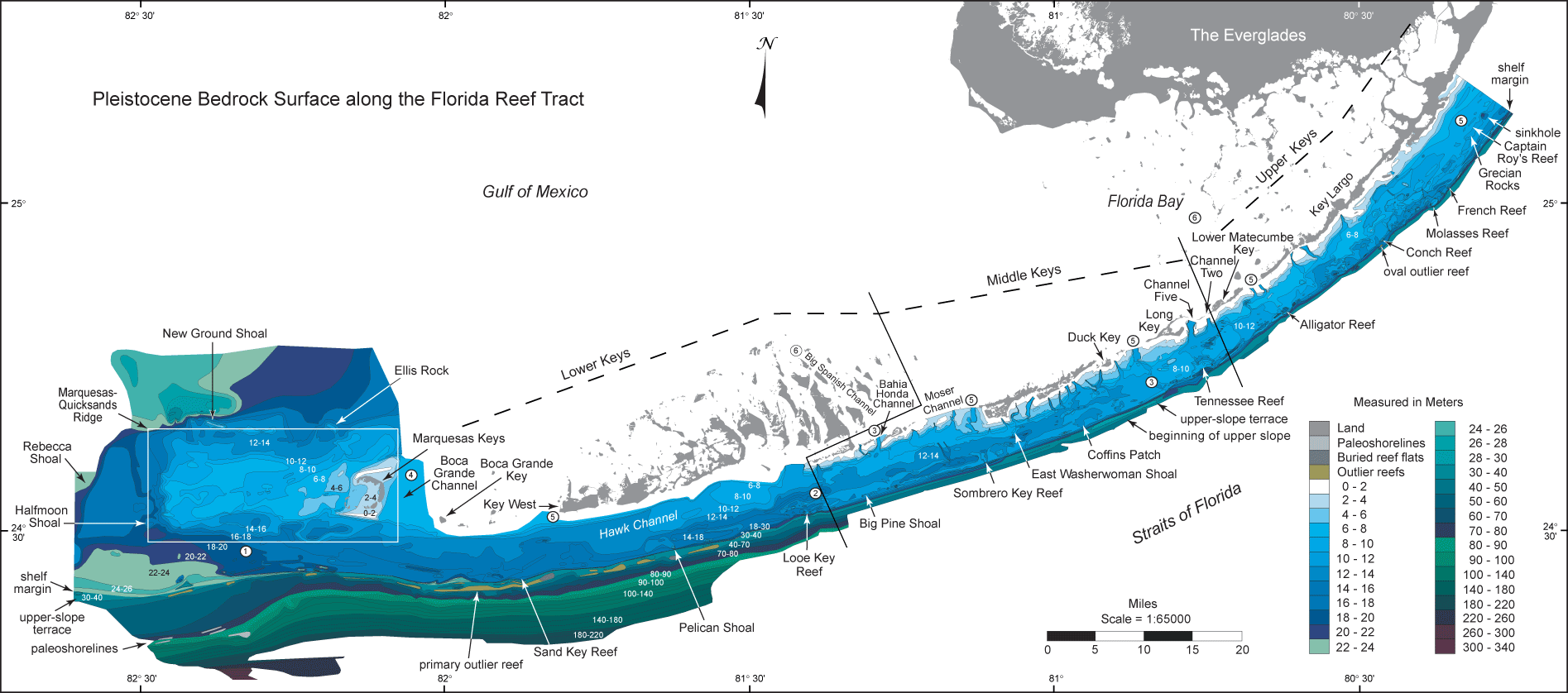
Bedrock Surface map: Updated map of the bedrock surface shows contours of regional Pleistocene topography from the northern Florida Keys to west of The Quicksands. (From Lidz et al., 2003). The contours were derived from USGS geophysical data combined with selected analogous data of Enos (1977; see Data Integration section). Structure contours and numbers on colors are in meters below present sea level. Dogleg and diagonal lines divide upper, middle, and lower Keys.
Colors represent different bedrock elevations ranging from highest (pale blues) to lower (darker blues) to lowest (shades of darkest blues and greens). Outlier reefs (Lidz et al., 1991) are in shades of brown (light = high relief, dark = low relief or buried). The map scale is too small to show all four tracts of outlier reefs that occur off Rock Key and Sand Key Reefs, located at the shelf edge southwest of Key West. The shelf-margin fossil reef coincides with the dark blue line just landward of the outlier reefs. Note the elevated ridge (in large white rectangle) on which the Marquesas Keys are located. The most extensive areas of pale colors (i.e., shallowest depths mapped) are around the Marquesas Keys and along the inner shelf of the middle and upper Keys. Also note the generally margin-parallel nature of bedrock trends seaward of the keys.
Contacts between colors can be interpreted to represent positions and shapes of Holocene shorelines as sea level rose. Shelf-wide, bedrock elevations are several meters lower to the southwest than northeast, indicating the shelf flooded from southwest to northeast. Flooding direction is confirmed by radioisotope dates on Holocene corals. Circled numbers denote sequential 'stages' in which various areas of the shelf flooded: 1 at 18 m below present sea level; 2 at 14 m; 3 at 10 m; 4 at 6 m; 5 at 4 m; and 6 at 2 m. (Modified from Lidz et al., 2003).
|
Can't see the printable PDF version? Get the free Adobe Acrobat® Reader. |

![]() U.S. Department of the Interior |
U.S. Geological Survey
U.S. Department of the Interior |
U.S. Geological Survey
URL: [disc] /pubs/pp/2007/1751/professional-paper/figures/bedrock-surface.html
Page Contact Information: Feedback
Page Last Modified: December 01, 2016 @ 04:11 PM (JSS)
