FISC - St. Petersburg
|
Tile 11
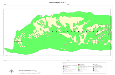
The Quicksands: The Quicksands are a significant deposit of non-oolitic carbonate sand that forms a belt 47 km long by 28 km wide by, on average, 1 to 2 m thick (Fig. 136; see Sediment Thickness map and Benthic Ecosystems for Tile 11). The Quicksands were so named because the sands are always in motion. The surface of the sand belt is ornamented with large (5-m high) migrating tidal bars oriented in a north-trending direction, on which sand waves oriented in a west-trending direction are superimposed (Fig. 133A). Crests of some sand waves are awash at low tide. Strong reversing tidal currents flowing between the Gulf of Mexico and the Straits of Florida mold the sand. The sand waves migrate over bedrock to the east (Fig. 133B). The deposit thickens to the west where sand waves overlie Holocene sediments as thick as 12 m (Figs. 133C, 135). Westward-dipping accretionary bedding indicates that net migration of the sands is to the west, despite north-south movement of tidal currents. Westward sediment transport in the lower Keys and the sediment-free channel floor in Boca Grande Channel indicate that the entire sand accumulation probably was, and still is, being generated on the ridge.
Thin-section analyses of Quicksands surface sediments showed that plates of the calcified codiacian alga Halimeda (e.g., Fig. 12G) were the most abundant grain in 91.3% of the samples examined (Shinn et al., 1990). Coral grains dominated the remaining 8.7% of samples. No other skeletal component tabulated (ostracod/mollusc, echinoid, benthic foraminifera, bryozoa, red algae) was a significant contributor to the sands at the time of sampling (1985). Sediments within the Marquesas Keys lagoon consist primarily of seagrass-covered lime mud. The mud flats are about 3 to 4 m thick, as determined by probing with a rod and piston coring to bedrock, and are exposed during extremely low spring tides (Shinn et al., 1990; see Sediment Thickness map and Benthic Ecosystems for Tile 9). Sediments along the island perimeter are coarser grained, and thickness decreases steadily from ~3 m to 0 m off the north, east, and south edges of the islands. Immediately west of the Marquesas Keys, the fine-grained lagoonal muds thin, and the sediment gradually and transitionally becomes the cross-bedded Halimeda sands that prevail throughout The Quicksands (e.g., Hudson, 1985). The absence of oolitically coated grains in thin sections of Quicksands sands is a mystery. Ooids (now the Miami Limestone) formed over large areas at opposite ends of the Key Largo Limestone coral reef during the highstand of sea level about 125 ka. Radiometric dates on oolitic limestones recovered from four stepped paleoshoreline beach deposits within 124 m of water southwest of the Marquesas Keys indicate that ooid precipitation was occurring as recently as around 14 ka (Locker et al., 1996). Bedforms and strong currents in The Quicksands are like those of the well-known ooid-bar areas of the Bahamas (e.g., Illing, 1954; Purdy, 1961; Ball, 1967; Hoffmeister et al., 1967; Hine, 1977; Halley et al., 1983) and the Persian Gulf (Loreau and Purser, 1973). Although hydrodynamic characteristics in The Quicksands seem to be similar to the ooid-precipitating environments of the Bahamas, the geologic and oceanographic setting differs. The Quicksands are located about 10 to 12 km from the deep water of the Florida Straits, whereas ooid bars in the Bahamas occur either next to or within 1 km of deep, clear water. Water color and clarity also differ. In the Gulf of Mexico, the water is green to greenish yellow, with abundant visible suspended particles. Visibility seldom exceeds 8 m. Clear water from the Florida Straits does not reach The Quicksands, even at high tide. Shinn et al. (1990) suspected that water in the area might be supersaturated with respect to calcium carbonate, as is required for ooid precipitation. However, those authors also speculated that the suspended particles may inhibit nucleation for ooid formation, or that water chemistry may differ from Bahamian ooid areas. Proximity to coral reefs may also play a role. A broad area of poorly developed coral reefs lies between The Quicksands and the shelf margin. The reefs may be biologically removing carbonate from the water before it reaches The Quicksands. Lloyd et al. (1987) suggested biological removal to explain the lack of ooids on a beach fronted by reefs in the Turks and Caicos Islands (Bahamas). Time should not be an issue. Radiocarbon dating has shown that Bahamian ooids can form in less than 160 years (Martin and Ginsburg, 1965), and Turks and Caicos ooids in less than 1,000 years (Lloyd et al., 1987). Sea-level curves for Bermuda (Neumann, 1971) and Florida (Fig. 102B; Robbin, 1984) indicate the sea has remained at about the same level (and thus, hydrologic conditions should have been similar) for the past 2 ka. Thus, if all conditions were optimal, this period of time should have been sufficient for ooids to form. Worthy of further study, the geochemical enigma surrounding lack of ooids in the carbonate Quicksands may have implications for the occurrence of cross-bedded, non-oolitically coated carbonate grains in ancient limestone sections. The U.S. Navy has long used The Quicksands area for target practice. Several derelict ships have been placed there over the years for practice bombing and machine-gunning exercises. Spanish treasure has also been recovered from the area. |

![]() U.S. Department of the Interior |
U.S. Geological Survey
U.S. Department of the Interior |
U.S. Geological Survey
URL: [disc] /pubs/pp/2007/1751/professional-paper/tile11/quicksands.html
Page Contact Information: Feedback
Page Last Modified: December 01, 2016 @ 04:13 PM (JSS)