FISC - St. Petersburg
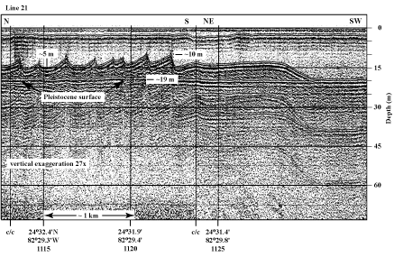
Figure 71. Profile of sand waves on channel bottom west of Halfmoon Shoal in the Gulf of Mexico (Fig. 6C) shows examples of true and apparent geometric patterns (from Shinn et al., 1990). From left to right, the N-S portion of the seismic line crossed perpendicular to 5-m-high sand waves and shows their true images. The vessel then made a course change (c/c) to NE-SW and crossed tangential to the end of the sand-wave field. Note how the image of the last sand wave has become broad and flat, giving an apparent image of an elongated smoothed section of sand. 'Multiples' are an artifact common in seismic-reflection data. These reflections replicate those of existing, overlying, geologic surfaces and should not be regarded as representing any subsurface stratigraphic horizon. Latitude and longitude below vertical time lines on profile in degrees and decimal minutes based on Loran C TDs (Time Differences). Hours (military time) below coordinates serve as navigational correlation points along seismic line.
|
Can't see the printable PDF version? Get the free Adobe Acrobat® Reader. |

![]() U.S. Department of the Interior |
U.S. Geological Survey
U.S. Department of the Interior |
U.S. Geological Survey
URL: [disc] /pubs/pp/2007/1751/professional-paper/tile4/figures/fig71.html
Page Contact Information: Feedback
Page Last Modified: December 01, 2016 @ 04:13 PM (JSS)
