|
 |
 |
Primary Products - Overview Maps & Evolution Overview:
|
|
|
|
|
|
|
|
|
|
|
|
|
|
|
|
|
|
|
|
 |
|
|
|
|
|
|
|
|
|
|
|
|
|
|
|
Tile 7/8
Hurricanes, Storm Surge, and Rising Sea Level: Physically, the most destructive natural force to affect Florida is hurricanes (Fig. 100A, 100B, 100C). Hurricane season extends from June 1 through November 30, though storms occasionally occur outside this time frame. Elements of atmospheric, terrestrial, and oceanic sources combine to cause damage in Florida: wind, low-lying elevation of the coastal topography, and flood and ebb surge (Fig. 101).
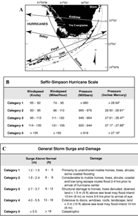 Figure 100. (A) Map shows paths of hurricanes that impacted south Florida between 1952 and 1992 (from Lidz and Hallock, 2000; the time frame is relative to the 1952, 1963, and 1989 sampling years for the sedimentary petrology studies). The year and Saffir-Simpson intensity at time of landfall are: Donna (1960, Category 4); Betsy (1965, Category 3); Inez (1966, Category 1); Floyd (1987, Category 1); Andrew (1992, Category 4). Hurricanes Betsy and Inez reached maximum intensity of Category 4 over open water. Prior to landfall, Hurricanes Donna and Andrew were both Category 5 storms. Hurricane Floyd did not intensify beyond Category 1. (B) The Saffir-Simpson scale (Simpson, 1974) is a categorization based on destructive intensity (windspeed) of a hurricane. (For more information, see http://www.aoml.noaa.gov/hrd/nhurr97/SFSIMP.HTM.) (C) Storm-surge values depend on wind and wave height and on the shape and slope of the continental shelf in the landfall region. All else being equal, the shallower and lower-gradient the shelf, the higher the surge. The lower the coastal elevation, the farther inland the surge will penetrate. Storm categorization is used to predict property damage and flooding. For more information about storm-impact prediction, see (National Assessment of Coastal Change Hazards). For information on impacts of 2004 storms (Hurricanes Charley, Frances, Jeanne, and Ivan) in Florida and along the Gulf Coast, see Hurricane and Extreme Storm Impact Studies. [larger version] Figure 100. (A) Map shows paths of hurricanes that impacted south Florida between 1952 and 1992 (from Lidz and Hallock, 2000; the time frame is relative to the 1952, 1963, and 1989 sampling years for the sedimentary petrology studies). The year and Saffir-Simpson intensity at time of landfall are: Donna (1960, Category 4); Betsy (1965, Category 3); Inez (1966, Category 1); Floyd (1987, Category 1); Andrew (1992, Category 4). Hurricanes Betsy and Inez reached maximum intensity of Category 4 over open water. Prior to landfall, Hurricanes Donna and Andrew were both Category 5 storms. Hurricane Floyd did not intensify beyond Category 1. (B) The Saffir-Simpson scale (Simpson, 1974) is a categorization based on destructive intensity (windspeed) of a hurricane. (For more information, see http://www.aoml.noaa.gov/hrd/nhurr97/SFSIMP.HTM.) (C) Storm-surge values depend on wind and wave height and on the shape and slope of the continental shelf in the landfall region. All else being equal, the shallower and lower-gradient the shelf, the higher the surge. The lower the coastal elevation, the farther inland the surge will penetrate. Storm categorization is used to predict property damage and flooding. For more information about storm-impact prediction, see (National Assessment of Coastal Change Hazards). For information on impacts of 2004 storms (Hurricanes Charley, Frances, Jeanne, and Ivan) in Florida and along the Gulf Coast, see Hurricane and Extreme Storm Impact Studies. [larger version] |
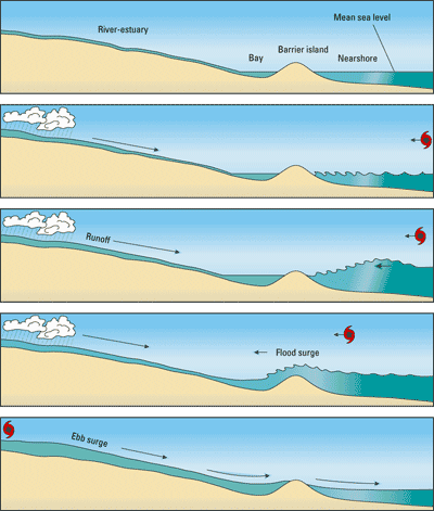
Figure 101. Sketch shows generalized hurricane-associated processes as the eye approaches a low-lying coastline. Note the dome or flood surge of water that is pushed ahead of the eye. Once run up on land, the dome of water will return to the sea as ebb surge. Shoreline environments are in effect potentially impacted by surge forces twice. [larger version] |
Hurricanes can devastate coral reefs on a grand scale, but recovery from the blunt trauma has been rapid in the past. Hurricane Donna struck the middle Keys in 1960 with Category 4 force (sustained 140-mph winds gusting to 180 mph; Fig. 100B). Wind-driven waves and surf as high as 4.5 m north of the eye pounded the outer reefs, displacing boulder-size rubble and moving great amounts of seagrass-free sand ~45 m landward onto seagrass meadows (e.g., Ball et al., 1967). The storm caused widespread scattering of live coral fragments, but many pieces became growth sites of new colonies. Within 1 year after the storm, there was virtually no sign of coral reef destruction in the middle Keys (Shinn, 1976). Due to increased diseases, recovery has not occurred after more recent storms (Jaap et al.,1998; Lang, 2003; Sutherland et al., 2004).
Flooding due to heavy rainfall, even in storms of lesser magnitude, can be devastating to inland homesteads, crops, and livestock (e.g., Bales et al., 2000). Storms of Category 4 and 5 magnitudes cause extensive onshore damage (Fig. 100C). At the shoreline, the mangrove forest, a protected ecosystem, and other coastal vegetation take far longer than coral reefs to recover. Urban infrastructure, waterfront homes, and recreational watercraft can take years to restore. Given that sea level has been rising over the last 10 ka (Fig. 102A, 102B; e.g., Milliman and Emery, 1968; Buddemeier and Smith, 1988; Wanless, 1989; Lighty et al., 1982; Robbin, 1984; Fairbanks, 1989; Mallinson et al., 2003) and is projected to continue rising (Fig. 102C; e.g., Albritton et al., 2001), future hurricane-associated damages to life, limb, and property may well exceed those which occur at present sea level and population density (Fig. 103A, 103B).
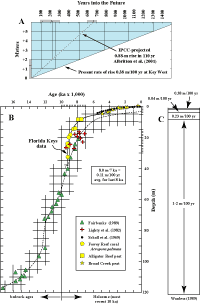 Figure 102. (A) Diagram shows time that it will take for sea level to inundate the Florida Keys at its present measured rate of rise (solid diagonal). Dashed line represents predicted rise in mean global sea level from 1990 to 2100 (Albritton et al., 2001) extrapolated to +1-m mark (~110 years) and +2-m mark (~225 years) and beyond. Most dry land in the keys will disappear with a rise in sea level of 1 to 2 m (figure modified from Lidz and Shinn, 1991). IPCC = Intergovernmental Panel on Climate Change. (B) The sea-level curve for the Florida reef tract is well constrained by local proxy data (in conventional 14C ages) as modified (Lidz and Shinn, 1991) from the curve of Robbin (1984). Data from 8 ka to the present are considered reliable. Question mark indicates lack of reliable local data older than ~8 ka. (C) Rates of sea-level rise. Upper part of figure shows rise as measured since 1932 by tide gauges at Key West. There is some disagreement as to whether rate of rise has accelerated in Key West, as is shown by Wanless (1989), or has remained relatively uniform, as stated by Hanson and Maul (1993). [larger version] Figure 102. (A) Diagram shows time that it will take for sea level to inundate the Florida Keys at its present measured rate of rise (solid diagonal). Dashed line represents predicted rise in mean global sea level from 1990 to 2100 (Albritton et al., 2001) extrapolated to +1-m mark (~110 years) and +2-m mark (~225 years) and beyond. Most dry land in the keys will disappear with a rise in sea level of 1 to 2 m (figure modified from Lidz and Shinn, 1991). IPCC = Intergovernmental Panel on Climate Change. (B) The sea-level curve for the Florida reef tract is well constrained by local proxy data (in conventional 14C ages) as modified (Lidz and Shinn, 1991) from the curve of Robbin (1984). Data from 8 ka to the present are considered reliable. Question mark indicates lack of reliable local data older than ~8 ka. (C) Rates of sea-level rise. Upper part of figure shows rise as measured since 1932 by tide gauges at Key West. There is some disagreement as to whether rate of rise has accelerated in Key West, as is shown by Wanless (1989), or has remained relatively uniform, as stated by Hanson and Maul (1993). [larger version] |
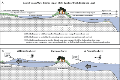
Figure 103. Schematic diagram shows impact of rising sea level and hurricane flood surge on the Florida Keys and low-lying Everglades. (A) Landward movement of ocean wave-energy impact zones with rising sea level (not to scale). (B) Hurricane-flood surge at present sea level and at a higher sea level (not to scale). A flood-surge dome precedes hurricane landfall. Right side of figure: the dome of water would engulf the keys and raise water level in Florida Bay as the hurricane moves inland. The bay would be subject to an ebb surge as water flow reverses after hurricane passage. At present sea level, the keys receive the most damage. Left side of figure: under conditions of higher sea level, the flood-surge dome would cross the keys and would come ashore in the low-lying coastal region of the Everglades. The coastal region would receive greater damage and would also experience an ebb surge. Higher sea levels in (A) are arbitrary, but the sketch implies that sea level at position 2 is not as high as the highest elevation of the keys (~ +5.5 m, Lidz and Shinn, 1991), and at position 3 the keys are inundated. Note in (A) that the present water level in Florida Bay is higher than the level of the Atlantic (see Figs. 24, 25A, 25B). An effect not shown is ebb-surge runoff (Fig. 101): water surging onshore, then receding. [larger version] |
continue to: Geologic Highlights
|


