![]()
SATELLITE IMAGE ATLAS OF GLACIERS
OF THE WORLD
GLACIERS OF IRIAN JAYA,
INDONESIA, AND NEW ZEALAND
GLACIERS OF IRIAN JAYA, INDONESIA
By IAN ALLISON1,
and JAMES A. PETERSON2
Abstract
Three small perennial ice fields with a total area of about 7.5 ± 0.5 km2 are situated on Puncak Jaya massif, Puncak Mandala, and Ngga Pilimsit in the Central Range of Irian Jaya. The largest of these is the one on Puncak Jaya massif with an area of about 7 km2. The other ice fields each have a diameter of only several hundred meters. All the ice fields have experienced extensive and rapid retreat during this century. Landsat imagery has beer) used in conjunction with field measurements to locate, describe, and monitor changes in the ice fields.
The high peaks of the 2,500-km-long Pegunungan Maoke3 or Central Range, of equatorial New Guinea presently support glaciers in three ice areas, all of which are in the Indonesian territory of Irian Jaya: the Puncak Jaya massif (Carstensz; 4°05'S., 137°11'E.; 4,884 m), Puncak Mandala (Julianatop; 4°48'S., 140°20'E.; 4,640 m), and Ngga Pilimsit (Idenburg-top; 4°03'S., 137°02'E.; 4,717 m) (fig. 1). An ice cap on Puncak Trikora (Wilhelmina-top; 4°15'S., 138°45'E.; 4,730 m) disappeared sometime between 1939 and 1962. The extensive retreat of all these glaciers, which has occurred during this century, has been documented by Mercer (1967) and by Peterson and others (1973).
 |
Figure 1.-Index map of Irian Jaya showing the location of the highest mountains (after fig. 1 in Peterson and others, 1973). |
The largest of these ice-covered areas, on the massif dominated by Puncak Jaya, totals about 7 km2 . This area was studied in some detail by two Australian Universities' Carstensz Glaciers Expeditions (CGE), and the ice area and their recent history of retreat are described by Allison and Peterson (1976). The glaciers are situated atop a ridge of folded Tertiary limestone, the axis of which trends west-northwest to east-southeast, and can be divided into four main ice masses (fig. 2): the Northwall Firn (separated into three parts by 1972), the Meren Glacier, the Carstensz Glacier (plus the small niche glaciers, the Wollaston and Van de Water, which descend from the same firn field), and the Southwall Hanging Glaciers. Details of these ice masses are tabulated by Müller (1977).
 |
Figure
2.-Map of
the ice fields of the Puncak Jaya area showing retreat of the ice boundaries
since about 1800 to 1850 A.D. (from 1:20,000-scale Australian Universities'
Carstensz Glaciers Expeditions). |
 |
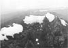
Figure
3.-Oblique aerial photograph looking east at several of the glaciers
on Puncak Jaya in 1936. Left to right: Northwall Firn, Meren Glacier, and
Carstensz Glacier. Photograph no. S.136 by J.J. Dozy. |
The Meren and Carstensz Glaciers flow westward in parallel glacial valleys, the Meren Valley and Yellow Valley, respectively (figs. 2, 3). In 1972, the Meren Glacier had an area of 1.9 km2, a mean thickness of 40 m, and measured surface velocities of up to 30 m a-1; the Carstensz; Glacier had an area of 0.9 km2, a mean thickness of 38 m, and measured surface velocities of up to 18 m a-1. The morphology and dynamics of both these glaciers are described by Allison (1975 and 1976).
Seasonal climatic variations on the Puncak Jaya massif are very slight. Monthly mean temperatures vary by less than 0.5 °C during the year, and there appears to be no marked seasonal variation in precipitation, radiation, or cloud cover (Allison and Bennett, 1976). As a consequence, the net balance of the glaciers remains seasonally uniform, and ablation occurs year round below the equilibrium line; above the equilibrium line accumulation occurs year round. Hence the snowline elevation on the glacier remains near the equilibrium-line altitude except for short periods after heavy snowfalls. Mass-balance measurements in 1972 indicated an equilibrium-line altitude of 4,580 m with the net annual balance reaching ± 1 m a-1 water equivalent (w.e.) at 4,800 m elevation, near the top of the glaciers, and -5 m a-1 w.e. at 4,400 m, near the termini. Because ablation occurs throughout the year in the ablation zone, the vertical budget gradient (activity index) for these glaciers is high. Both the Meren and Carstensz Glaciers had a negative mass budget in 1972, which is consistent with their observed retreat.The ice extent on the Puncak Jaya massif is small, but the area is one of only a few present-day, ice-covered equatorial regions. The rapid and continuing retreat of the glaciers during this century indicates that the mass budget has been consistently negative. This suggests a climatic change, of which the glaciers are a sensitive indicator. Using a numerical model of the glaciers and their dynamics, Allison and Kruss (1977) estimated the change in mass budget necessary to give the observed retreat, between about 1850 and 1972, of more than 2 km for the Carstensz and more than 3 km for the Meren Glacier. They showed that a steady rise of the equilibrium-line elevation at a rate of 80 m per century allowed the model to match the observed retreat and that the most likely explanation for the mass-balance change was a warming of the regional air temperature by 0.6°C per century.
Subsequent observations show that the terminus of the Meren Glacier retreated about 200 m between 1973 and 1976 and that the Carstensz Glacier retreated 50 m during the same period of time (Dr. L. Hansen, pers. commun.). Continued monitoring of the glaciers is obviously needed because of the climatic implications.
Far less, however, is known about the other glaciers in Irian Jaya. The ice caps on Ngga Pilimsit (about 12 km northwest of Puncak Jaya) and on Puncak Mandala each have a diameter of only several hundred meters (Mercer, 1967; Peterson and others, 1973).
Aerial Photography
Because of the area's remoteness and the persistent cloud cover, the available aerial photography of the Irian Jaya glaciers is limited. Before 1975, the only vertical aerial photographs of the Puncak Jaya glaciers were obtained in 1942 during an aerial survey, with a trimetrogon camera, by the United States Army Air Force (USAAF). Most of the Northwall Firn is covered in three vertical frames acquired along one flight line of this survey (USAAF photograph no. 4 CS-5MC20-23V, frames 117 to 119, fig. 4), but the two major valley glaciers (the Meren and the Carstensz), the western end of the Northwall Firn, and Ngga Pilimsit are covered only by the trimetrogon oblique aerial photographs (USAAF photograph nos. 23R-119 (fig. 5), 23L-117, and 23L-113, respectively). The ice fields on the south wall are not covered by this flight line.
| Figure 4.-Mosaic of U.S. Army Air Force vertical aerial photographs of the Northwall Firn in 1942. | |
 |
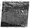
Figure
5.-U.S. Army Air Force trimetrogon oblique aerial photograph looking
south at the glaciers in 1942. Foreground, Northwall Firn; center, Meren
Glacier, background, Carstensz Glacier. |
 |
Figure
6.-Oblique aerial photograph looking east at the glaciers in 1972. Photograph
acquired during the Carstensz Glaciers Expeditions (CGE). Compare with figure
3. Left to right: Northwall Firn, Meren Glacier, and Carstensz Glacier. |
More recent medium altitude (up to 11,500 m), vertical aerial photographs of
the region were obtained during combined Indonesian and Australian military
mapping operations between 1976 and 1981. Photographs V2F-RAAF-8466, Run 19E,
frames 190-194, September 1976, cover the Northwall Firn only, while photographs
V2F-RAAF-9922, Run 0022, frames 9147 and 9148, January 1981, give complete coverage
of the glaciers on the massif but were taken after a snowfall, which makes determination
of the ice margins difficult.
Data on the reduction of the total glaciated area on the Puncak Jaya massif come mostly from oblique aerial photographs. These include those taken during the 1936 Colijn Expedition (Dozy, 1938; Mercer, 1967) (see fig. 3), during the 1971/72 CGE (fig. 6), and during occasional light aircraft overflights of the area. The rapid retreat of the Puncak Jaya glaciers is shown dramatically by comparing figure 3 with figure 6.
Reports of changes of the ice caps on Ngga Pilimsit and Puncak Mandala have been based on oblique aerial photography and some groundbased observations (Mercer, 1967; Peterson and others, 1973).
The largest-scale map of the Puncak Jaya glacier area is a 1:20,000-scale topographic map, produced by the CGE from the 1971 to 1973 ground survey and photogrammetry of the 1942 USAAF vertical aerial photographs (using CGE ground control) (Anderson, 1976). The contour interval over most of this map is 50 m, with a 10-m contour interval on the Carstensz and Meren Glaciers.
The ice limits at different times, as shown in figure 2, are based on this map. The reliability of the ice limits is indicated in the explanation. While the reliability is generally good at the snouts of the Meren and Carstensz Glaciers, the eastern and southern ice boundaries are based only on uncontrolled oblique aerial photographs.
A small-scale map (1:250,000) was used by the CGE to delineate the maximum extent of the last Pleistocene (Wisconsinan, or Würm) glaciation. This map was based on the 1:250,000-scale Joint Operations Graphic Series 1501, Sheets SB53-4 and SB53-16, with corrections made to the drainage net from field observations. The glacial geology features (morainal ridges, glaciated headwalls, and probable maximum extent of glaciation) were mapped from the 1942 USAAF trimetrogon oblique aerial photographs and field reconnaissance by the CGE and others (Hope and Peterson, 1976).
The inaccessibility of the region for both conventional and aerial surveys makes monitoring of the glaciers by satellite a particularly attractive proposition. Because the largest of the glaciers on Puncak Jaya covers less than 7 km2, only the Landsat series of spacecraft has offered sufficient resolution for mapping even gross changes. Unfortunately, the mountains of New Guinea are usually obscured by cloud cover, and only one Landsat image (see fig. 8) showing the Puncak Jaya glaciers prior to 1980 is available (1643-00253, band 7; 27 April 1974; Path 110, Row 63) (fig. 7 and table 1).
 |
Figure 7.-Index map to the optimum Landsat 1,2, and 3 images of the glaciers of Irian Jaya. |
 |
Figure
8.-Landsat 1 image (1643-00253, band 7; 27 April 1974) showing the ice
fields of the Puncak Jaya region (near center). The strike of the bare limestone
outcrops that form the crestal ridge is west-northwest. To the north of
the glaciers is the glacial-drift-veneered limestone Kemabu Plateau and,
at the bottom of the image, the Arafura Sea. NASA Landsat image from the
EROS Data Center. |
More recent images showing the glaciers have, however, become available since the Australian Landsat station started to receive data from the Irian Jaya region in 1980. The Puncak Jaya and Ngga Pilimsit glaciers are clearly seen in Landsat 4 multispectral scanner (MSS) images for 8 September 1982, 30 January 1983, and 19 March 1983, while the small Puncak Mandala ice cap can be identified in a Landsat 2 MSS image for 19 August 1981 and Landsat 4 MSS images for 21 March 1983 and 3 January 1984 (table 1).
3The names used are those approved by the U.S. Board of Geographic Names and published by Garren and others (1982). In the case of glaciers and other geographic features where there is no officially approved name, the name generally accepted in the glaciological literature has been used.
| Home | Volume Contents | Glaciers of Irian Jaya,Indonesia (con't.) |
U.S. Geological Survey, U.S.Department
of the Interior
This page is https://pubs.usgs.gov/prof/p1386h/indonesia/indonesia.html
Contact: Richard S. Williams, Jr., and
Jane G. Ferrigno
Last modified 04.28.00