GLACIERS OF SOUTH AMERICA--
GLACIERS OF BOLIVIA
By EKKEHARD JORDAN1
Present-day glaciers of Bolivia are restricted to the highest peaks of the Andes Mountains. In the Cordillera Occidental, the glaciers are found as crater glaciers, small summit ice caps, and outlet glaciers on the extinct volcanoes in the northern part of the country. Their total surface area is about 10 square kilometers. Most of the glaciers are located in the Cordillera Oriental in the Cordilleras Apolobamba, Real, and Tres Cruces and in Nevado Santa Vera Cruz2 as ice caps, valley glaciers, and mountain glaciers. Their surface area covers more than 550 square kilometers. Because of the limited precipitation, no glaciers exist in southern Bolivia.
During the Pleistocene, glacierization was much more extensive. Presently glacierized areas were larger, and glaciers were also found in areas that no longer support permanent ice. In the Cordillera Occidental, terminal moraines have been found below the 4,500-meter elevation, and in the Cordillera Oriental, at slightly above 3,000 meters. In between, in the Altiplano, traces of glaciation rise 100-200 meters higher from the center to the margin of that area.
The location, distribution, and mass-balance of Bolivian glaciers are the result of the climate and the orientation and elevation of its mountain ranges. In contrast to extratropical glaciers, accumulation takes place during the summer, and ablation takes place during the winter and interseasonal periods. The daily cloud-cover cycle, which leaves the glaciers exposed to morning solar radiation from the north and east and protects the western slopes in the afternoon, results in a substantially lower snowline on the western and southern slopes (100 to 300 meters lower).
The glaciers of Bolivia are covered by maps, aerial photographs, and satellite images of varying degrees of usefulness. Accurate maps at 1:50,000 scale cover the Cordillera Real. Vertical aerial photographs having scales between 1:30,000 and 1:80,000 cover all the glacierized areas of Bolivia and range in quality from good to satisfactory. Satellite images with resolutions ranging from 5 to 79 meters are also available, and although they may be limited by resolution, cloudiness, shadowing, or spectral discrimination, they offer a useful tool for frequently monitoring glacier variation.
Because Bolivia lies completely within the tropics, glaciers can be found only at the highest elevations (Francou, 1993). Hence, glaciers are restricted to the highest mountain peaks in the Andean region of Bolivia.
Annual precipitation within Bolivia is variable, decreasing to less than 200 mm a-1 in the southwest. As a consequence, even the highest peaks of the Andes Mountains at 6,000 m and above cannot sustain glaciers south of lat 18°30' S. and have only temporary snow patches (see table 1 and fig. 1). No glaciers exist anywhere in southern Bolivia. The southern limit of glaciers in Bolivia is roughly equivalent to the northern line of the large salars, such as Salar de Coipasa and Salar de Uyuni, in the central plateau (Altiplano) of the Andes.
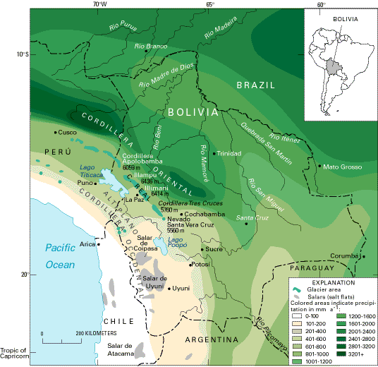
Figure 1.--Glacierized areas of Bolivia showing location of glaciers and distribution and amount of precipitation. It is evident that the southwestern part of the country does not receive enough precipitation to maintain glaciers on even the highest peaks. The location of present glaciers is shown with a tint. Information about the area, number, and elevation of the glaciers in each glacierized region is given in table 1.
Table 1.-- Glaciers of the Bolivian Andes on 1 November 1984
[Taken from Jordan, 1991, table 10. Leaders (--) not known]
|
Mountain group |
Latitude |
Longitude |
Glacier |
Highest elevation (meters) |
Lowest glacier terminus (meters) |
|||
|---|---|---|---|---|---|---|---|---|
|
|
|
|
Area square kilometers1 |
Percent |
Number |
Percent |
|
|
|
CORDILLERA ORIENTAL |
||||||||
|
CORDILLERA ORIENTAL |
14°37'-17°04' |
67°13'-69°14' |
591.600 |
100 |
1826 |
100 |
6,436 |
4,311 |
|
CORDILLERA APOLOBAMBA |
14°37'-15°04' |
68°58'-69°14' |
219.804 |
37.2 |
652 |
36 |
6,059 |
4,311 |
Chaupi Orko |
14°40' |
69°10' |
129.357 |
21.9 |
346 |
19 |
6,059 |
4,365 |
Cololo |
14°50' |
69°06' |
43.072 |
7.3 |
135 |
7.5 |
5,774 |
4,311 |
Ulla Khaya |
15°00' |
69°03' |
47.375 |
8 |
171 |
9.5 |
5,669 |
4,390 |
|
CORDILLERA DE MUÑECAS |
15°20'-15°38' |
68°33'-68°55' |
.684 |
.1 |
16 |
1 |
5,237 |
4,828 |
Morocollu |
15°20' |
68°55' |
.148 |
.03 |
8 |
.5 |
5,156 |
4,828 |
Cuchu |
15°38' |
68°33' |
.536 |
.1 |
8 |
.5 |
5,237 |
4,886 |
|
CORDILLERA REAL |
15°45'-16°40' |
67°40'-68°34' |
323.603 |
54.7 |
964 |
53 |
6,436 |
4,420 |
|
NORTHERN CORDILLERA REAL |
15°45'-16°20' |
68°01'-68°34' |
262.766 |
44.4 |
784 |
43 |
6,436 |
4,420 |
Illampu-Ancohuma |
15°50' |
68°30' |
103.099 |
17.4 |
147 |
8 |
6,436 |
4,438 |
Calzada-Chiaroco- Chachacomani |
16°00' |
68°20' |
94.072 |
15.9 |
251 |
14 |
6,127 |
4,676 |
Nigruni-Condoriri |
16°08' |
68°15' |
40.868 |
6.9 |
241 |
13 |
5,752 |
4,420 |
Saltuni-Huayna Potosí |
16°15' |
68°08' |
14.504 |
2.5 |
50 |
3 |
6,088 |
4,804 |
Zongo-Cumbre- Chacaltaya |
16°18' |
68°05' |
10.223 |
1.7 |
95 |
5 |
5,519 |
4,578 |
|
SOUTHERN CORDILLERA REAL |
16°20'-16°40' |
67°40'-67°58' |
60.837 |
10.3 |
180 |
10 |
6,414 |
4,499 |
Hampaturi-Taquesi |
16°26' |
67°52' |
11.685 |
2 |
70 |
4 |
5,548 |
4,723 |
Mururata |
16°30' |
67°47' |
17.207 |
2.9 |
75 |
4 |
5,836 |
4,592 |
Illimani |
16°38' |
67°44' |
31.945 |
5.4 |
35 |
2 |
6,414 |
4,499 |
|
CORDILLERA TRES CRUCES (QUIMSA CRUZ) |
16°47'-16°09' |
67°22'-67°32' |
45.276 |
7.7 |
177 |
9.5 |
5,760 |
4,708 |
Choquetanga |
16°54' |
67°22' |
6.992 |
1.2 |
21 |
1 |
5,541 |
4,812 |
High region of Tres Cruces |
16°56' |
67°24' |
38.284 |
6.5 |
156 |
8.5 |
5,760 |
4,708 |
|
NEVADO SANTA VERA CRUZ |
17°03'-17°04' |
67°13'-67°14' |
2.233 |
.4 |
17 |
1 |
5,560 |
4,853 |
|
CORDILLERA OCCIDENTAL |
||||||||
|
CORDILLERA OCCIDENTAL |
18°03'-18°25' |
68°53'-69°09' |
10 |
100 |
-- |
-- |
6,542 |
5,100 |
Nevado Sajama |
18°06' |
68°53' |
4 |
40 |
-- |
-- |
6,542 |
5,100 |
Nevados Payachata |
18°09' |
69°09' |
4 |
40 |
-- |
-- |
6,222 |
5,500 |
Cerros Quimsachata |
18°23' |
69°03' |
2 |
20 |
-- |
-- |
6,032 |
5,500 |
1Glacier areas based on analysis of 1975 aerial photographs and 1984 field measurements.
Glaciers in Bolivia are found in two main ranges of the Andes, the Cordillera Occidental along the western border with Chile and the Cordilleras Apolobamba, Real, and Tres Cruces and Nevado Santa Vera Cruz, which are the southern extension of the Cordillera Oriental in Perú. Between the Cordillera Apolobamba and Cordillera Real lies the Cordillera de Muñecaus, which has two very small glacierized areas containing 16 small glaciers that have a total area of 0.1 km2 (table 1). The approximately 200-km-wide Altiplano between these two main ranges is no longer glacierized because it does not have sufficient elevation and (or) precipitation.
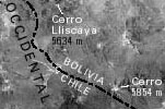
The type and areal extent of glaciers in the Cordillera Occidental and in the Cordilleras Apolobamba, Real, and Tres Cruces and Nevado Santa Vera Cruz are very diverse. The Cordillera Occidental consists exclusively of extinct volcanoes, and glaciers are limited to Nevado Sajama (6,542 m) and its neighboring volcanoes (fig. 2). In addition to crater glaciers, small summit ice caps commonly occur that have several outlet glaciers that terminate downslope (fig. 3). Their extent and total surface area are very small and scarcely amount to 10 km2 in Bolivia and northern (tropical) Chile. However, these are the glaciers that have the highest minimum elevation on Earth (table 1), except for the small icefield of the Chilean-Argentine stratovolcano Cerro/Volcán Llullaillaco (6,739 m) (Messerli and others, 1992, p. 262).
Figure 2.--Cordillera Occidental of Bolivia and Chile.
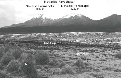
Figure 3.--Nevados Payachata of the Cordillera Occidental. The photograph is looking west from the foot of Nevado Sajama (lat 18°6'05"S., long 68°58'10" W.) at an elevation of 4,260 m at the end of the dry season. The snow has largely dissipated, and small glacier areas appear. In the center, extending across the entire picture are white salt efflorescences. The foreground is marked by thickets of Ichu grass on a hard cushion bog (Bofedal). Photographed by Ekkehard Jordan on 5 September 1980.
Substantially more significant, on the other hand, is the glacierization of the Cordilleras Apolobamba (figs. 4 and 5), Real (fig. 6), and Tres Cruces (fig. 7) and of Nevado Santa Vera Cruz (fig. 7) in the Cordillera Oriental. From a geological viewpoint, these cordilleras are strongly elevated intrusions whose slaty covers have been exposed by erosion and covered by glaciers. The nearly 600 km2 of glacier surface area is distributed over the four mountain groups of the Cordillera Oriental (fig. 8), whose characteristics are presented in table 1. Almost all types of glaciers are represented, including ice caps, valley glaciers, and mountain glaciers; the large variety of glacier types shows some similarity to the classic glacierized areas of the European Alps (see fig. 10). The similarity of topography has been thought to correspond to similar glacial phenomena. In the following discussion, however, emphasis will be placed on relating glacier type to climate.
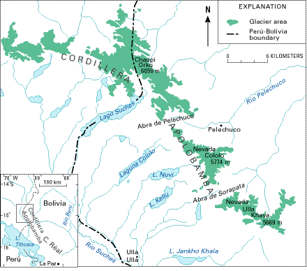
Figure 4.--Glacierized areas of the Cordillera Apolobamba in the Cordillera Oriental of Perú and Bolivia. This map is modified from a more detailed map by the author that was based on satellite images, aerial photographs, route drawings, and maps. Abbreviation: L., Lago/Laguna.
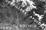 Figure 5.--Cordillera Apolobamba in Perú and Bolivia.
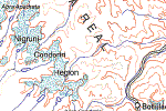
Figure 6.--Glacier distribution in the Cordillera Real.
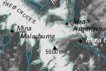
Figure 7.--Glacierized regions of the Cordillera Tres Cruces and Nevado Santa Vera Cruz.
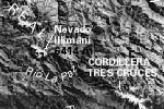
Figure 8.--Annotated Landsat 2 MSS image mosaic of glacierized regions of the Cordilleras Apolobamba, Real, Tres Cruces, and of Nevado Santa Vera Cruz of Bolivia.
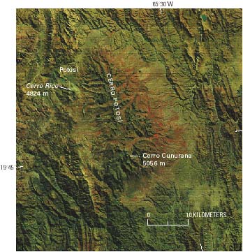
Figure 9.--Part of a Landsat 2 MSS false-color composite image enlarged to 1:500,000-scale showing traces of Pleistocene glaciation in the Cerro Potosí. The Cerro Potosí is one of the largest continuous areas of Pleistocene glaciation in the southeastern Bolivian highland, which today is not glacierized. The diversity of glacial forms can be distinguished on the satellite image; they extend from the highest pyramidal peak south of the mountain massif, which has an elevation slightly above 5,000 m (Cerro Cunurana, 5,056 m), to below 4,000 m, and they have even produced a small foreland glaciation in the southwest. During the glacial maximum, the glacierized area of this mountain range alone reached an extent larger than the total areal extent of the modern glacierization. It covered 700-800 km2 in the form of an ice-stream network. The eye-catching cone- or trumpet-shaped, typically glacially carved valleys tend to diverge radially and show the extreme relief of immense side moraines in the former terminus region. These are adjoined, particularly from the northwest to west to southwest, by immense alluvial cones descending to below 3,000 m. Because of its excellent water supply, the alluvial material is used intensively for agricultural purposes. The false-color composite image shows this indirectly by the distinctive red coloration of the chlorophyll-rich vegetation. The vegetation covers the land surface far into the dry season in these areas because of surface irrigation. The glacial lakes, which are numerous in the erosion area, as well as in the terminus region, of the Pleistocene glaciers, are proof of the rich water resources of the mountain range. These lakes represent natural, glacially supplied water reservoirs that have provided the mines and the former industrial center, Potosí, with drinking and municipal water. Directly south of Potosí the pronounced cone-shaped Cerro Rico (silver mountain) has lost its glacial shape as a result of undercutting by underground mining activity during the past centuries. This mountain, reaching an elevation of 4,824 m, was previously covered by a considerable ice cap. The Landsat image (2148-13415; 19 June 1975; Path 249, Row 74) is from the EROS Data Center, Sioux Falls, S. Dak.
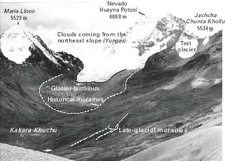
Figure 10.--Nevado Huayna Potosí (6,088 m) in the northern Cordillera Real. The annotated terrestrial photograph shows the west side of the Nevado Huayna Potosí (also called Caca-aca) and the surrounding landscape, which is similar to the European Alps. The slope glaciers join together into a short valley glacier at about 5,200 m elevation in the center of the photograph. The Holocene Epoch (labeled historical) and Pleistocene Epoch (late-glacial) moraines can be seen clearly. To their left and right are smaller slope and cirque glaciers. Toward noon, the clouds of the northeast slope (Yungas) move up across the pass as far as the peaks of the cordillera, where they protect the glaciers from solar radiation. Photographed by Ekkehard Jordan on 15 May 1980 from the road between Milluni and La Unión looking east (elevation, 4,900 m; lat 16°17'42"S., long 68°12'14"W.).
As is true elsewhere in the world, the mountains of Bolivia provide evidence of a substantially greater glaciation during the "Ice Age," which can be demonstrated on satellite images. However, because tectonic uplift of the Central Andes continued into the Quaternary Period (Troll and Finsterwalder, 1935) and the mountains reached their current elevation only in the middle of the Quaternary Period, only the two latest Pleistocene glaciations are documented by glacial deposits. During the Pleistocene glaciation, the presently glacierized regions were significantly expanded, and a large number of mountain massifs and volcanoes, which no longer have glaciers, supported ice caps (fig. 9). This is true of the Cordillera Occidental, where terminal moraines extend below the 4,500-m elevation, and of the Cordilleras Apolobamba, Real, and Tres Cruces and Nevado Santa Vera Cruz in the Cordillera Oriental, where it is possible to identify moraines below 3,500 m in elevation (Schulz, 1992). The author independently documented these moraines along the eastern escarpment up to slightly higher than 3,000 m. According to studies by Hastenrath (1967, 1971a, b), Nogami (1976), and Graf (1975, 1981) and the author's observations and analyses of aerial photographs, evidence of the lower elevation of more extensive Pleistocene glaciation in the Cordillera Occidental rises 100-200 m toward the south and from the center to the margin of the Altiplano. In contrast to the field evidence in the Cordillera Occidental, conditions in the mountain ranges to the east of the Altiplano are more complicated; no general pattern of Pleistocene glacier distribution can be recognized (Jordan and others, 1994). This is because of the much greater dissected relief in this region, which is seen in the cross-cutting valleys of Río Consata, Río La Paz, and Río Pilcomayo, that reach the border of the Altiplano. The position of mountain ranges within atmospheric circulation systems and the windward-leeward orientation and exposure play an important role in glacier development. The presence of a much colder climate during the Pleistocene has been confirmed by ice cores from Nevado Sajama (Thompson and others, 1998).
Manuscript approved for publication 18 March 1998.
1Lehrstuhl für Physische Geographie, Heinrich-Heine-Universität, Universitätstrasse 1, 40225 Düsseldorf, Germany.
2The names in this section conform to the usage authorized by the U.S. Board on Geographic Names in its Gazetteer of Bolivia (U.S. Board on Geographic Names, 1992), varient names and names not listed in the gazetteer are shown in italics.
| Home | Next |
U.S. Geological Survey, U.S.Department of the Interior