
PRE-1980 TEPHRA-FALL DEPOSITS ERUPTED FROM MOUNT ST. HELENS, WASHINGTON
By Donal R. Mullineaux
U. S. Geological Survey Professional Paper 1563
Tephra Set P
Set P consists of a series of thin layers of gray dacitic ash and small
lapilli that overlies a single basal layer of lapilli and bombs in ash (figs. 44, 45). All the layers contain abundant lithic fragments, and, overall, lithics are more
abundant than pumice clasts. Near the volcano, set P typically comprises a group of thin, light- and dark-gray
strata sandwiched between finer, reddish-brown and purplish-brown ash beds. The set as a whole is similar in thickness
and grain size to the group of thin beds that makes up the upper part of set Y but is separated from the latter
by the relatively thick ash bed pbp. Set P contains no layers as thick or as coarse as the major layers in the
older dacitic sets S, J, and Y or in the younger set W.
|
|
 |
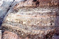
| Figure 44. Tephra set P. A, About 8 km northeast of Mount St. Helens where layer Pm is relatively
prominent and layer Py obscure (P-la). B, About 8 km east-southeast of the volcano where layer Pm is obscure
and layer Py prominent (P-1b). See also figure 53. (A=83K) (B=114K) |
Set P appears unweathered and is grayer in outcrops than underlying and
overlying tephra sets. No soil profiles were identified within or at the top of the set.
|
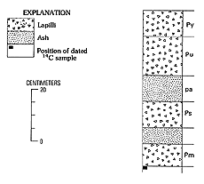
Figure 45. Composite columnar section of tephra set P, Mount St. Helens. (13K)
|
Pyroclastic-flow, surge, and ash-cloud deposits are conspicuously interbedded
with tephra in set P, from nearly its base to its top (Crandell and Mullineaux, 1973).
Composition
Set P consists chiefly of fresh lithic material and pumice; lithic material
predominates in all but the topmost layer Py. Both pumice and fresh lithic fragments contain only hypersthene and
hornblende as abundant ferromagnesian minerals. Chemical analyses of five pumice samples, including one from each
named layer, show a range of SiO2 from about 62.5 to 64.5 percent.
Diagnostic features
In the field, set P is recognizable as a sequence of thin, gray, fine-grained
beds that overlies a coarse, poorly sorted basal layer. Except for the basal layer, the set is similar in grain
size and bed thickness to the upper part of the underlying set Y. Ferromagnesian mineral content, however, readily
distinguishes set P from set Y and from other older tephras except the much coarser and strongly oxidized set J.
Set P is readily differentiated from the overlying scoriaceous set B by its
color, ferromagnesian mineral content, and chemical composition. It is distinguished from younger dacitic pumice
in set W by its high proportion of lithic fragments, absence of thick, coarse beds, stratigraphic relation to set
B, and ferromagnesian minerals. Set P pumice has lower ratios of hypersthene to hornblende than set W pumice, and
the hypersthene of set P has lower refractive indices.
Stratigraphic relations
Set P overlies set Y all around the volcano and is separated from it in
many places by ash bed pbp. Carbonaceous material, which is common at the base of set P, indicates that vegetation
was established after deposition of set Y but before eruption of set P.
Set P is overlain by set B near the volcano and is separated from it by the
purplish-brown ash bed v. No evidence of a time lapse between deposition of set P and the overlying ash was observed.
Distribution and thickness
Set P tephra containing lapilli crops out from northeast to south of the
volcano, and ash that is compositionally similar was observed in all other directions.
The maximum known thickness of set P tephra is about 50 cm, at the northeast
base of the mountain 5 km from its center (fig. 46). The actual thickness of tephra
probably is closer to 100 cm, but ash-size tephra near the volcano commonly cannot be distinguished satisfactorily
from ash-cloud deposits. At many sites the stratigraphic interval containing set P tephra is 200 - 300 cm vertically.
The excess thickness results from interbedded deposits of flowage origin.
|
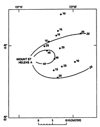
Figure 46. Thickness (in centimeters) of tephra set P, Mount St. Helens. Thickness is cumulative thickness
of strata interpreted as tephra; most stratigraphic sections also include interbedded deposits of flowage origin.
(8K)
|
At 8 km northeast of the volcano, set P is as thick as 40 cm, and at 8 km to
the southeast as thick as 30 cm. At that distance to the south and west, it probably consists of only a few centimeters
of ash. Although some beds of ash on the south and west flanks may be tephra, most ash there probably was derived
from flowage events.
Downwind, tephra of set P has been found 80-100 km to the northeast in Mount
Rainier National Park (Mullineaux, 1974) and about 50 km to the east at Mount Adams (J.W. Vallance, 1982, written
commun.). In addition, set P ash has been tentatively identified (Westgate 1977) about 400 km to the north-northeast
in Canada. These downwind beds have not been correlated with specific layers at Mount St. Helens.
Origin
Set P tephras probably originated in volumetrically small explosive eruptions
of molten and partly solidified and degassed magma. This activity was accompanied by the generation of numerous
lithic and pumiceous pyroclastic flows and growth of domes (Crandell and Mullineaux, 1973; Crandell, 1987). The
first eruption was highly explosive and opened the vent for the many pumiceous eruptions that followed. The abundance
of fresh lithic particles in pumiceous tephras suggests that domes formed between those eruptions.
Age
Set P was erupted between 3,000 and probably about 2,500 radiocarbon years
ago. The eruptions began shortly after 3,000 years ago; two radiocarbon dates from the base of layer Pm (samples
W-2675 and W-2829, table 2) and two from pyroclastic flows erupted early in Pine Creek
time (Crandell and others, 1981) are all between 3,000 and 2,900 years B.P.
The time at which set P eruptions ended is less well defined. No closely limiting
ages have been obtained from tephra immediately above the set: thus the younger age limit for set P is inferred
from ages of associated pyroclastic flows, which continued at least until about 2,500 years ago (Crandell, 1987(
(table 7, later). Radiocarbon dates of about 2,200 years B.P. from pyroclastic-flow deposits
well above the base of deposits of Castle Creek time (Crandell, 1987) (table 7, later)
suggest that eruptions of set P ended well before 2,200 years B.P.
Description of layers in set P
The four named layers in set P are illustrated by figure
47 and measured section P-1. Of the four, only the basal layer Pm is distinctive, in that it contains bombs
and blocks. Each of the other three described layers consists of multiple beds. Layer Pm and the overlying layer
Ps in the lower part of the set are separated from layers in the upper part by relatively thick, finer ash. No
weathering profiles are known that record time periods between eruptions of various parts of set P.
|
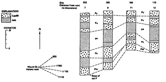
Figure 47. Columnar sections of tephra set P, from northeast to southeast of Mount St. Helens and diagram
of their locations relative to the central vent of the volcano. (20K)
|
Measured section P-1
Along south side of West Smith Creek valley, near center of sec. 30, T. 9 N., R. 6 E. See figure
44A.
| |
|
Thickness (centimeters) |
| 9. |
Ash bed v. Pinkish-brown fine ash |
15 |
| Set P |
|
|
| 8. |
Layer Py. |
|
| |
Ash, fine, yellowish-gray
|
1-2 |
| |
Ash, fine, gray
|
0.5-1 |
| |
Ash, yellow-gray; contains small pumice and lithic lapilli as much as 3 cm across
|
2 |
| 7. |
Ash, grayish-brown |
2 |
| 6. |
Layer Pu. |
|
| |
Ash, coarse, gray
|
1 |
| |
Lapilli, small, lithic and pumice, and ash; about one-third of lapilli are pumice
|
6 |
| |
Ash, coarse, lithic, in three beds or zones, each 1-2 cm thick, in fine ash
|
6-8 |
| 5. |
Bed pa. |
|
| |
Ash, fine, pinkish-brown
|
1 |
| |
Ash, fine, gray
|
1 |
| |
Ash, fine, brown (iron stained)
|
0.5 |
| |
Ash, fine, pinkish-brown
|
0.5 |
| |
Ash, coarse and fine, grayish-brown,
|
4-8 |
| |
Ash, fine, pale-brown, wavy bedded
|
1-2 |
| |
Ash, gray, wavy bedded
|
1-2 |
| |
Ash, fine, pale-brown
|
6-8 |
| 4. |
Layer Ps. |
|
| |
Lapilli, lithic and pumice, in ash
|
2 |
| |
Ash
|
0.5 |
| |
Lapilli, smaller than above, in ash
|
3 |
| |
Ash
|
0.5 |
| |
Lapilli, as in next higher bed, in ash
|
3 |
| 3. |
Ash, gray and brown |
10 |
| 2. |
Layer Pm. Lapilli and a few small bombs; generally in ash matrix; locally openwork, sparse ash matrix |
7-10 |
| 1. |
Ash bed pbp |
50 |
Layer Pm
Layer Pm is a single, thin, widespread deposit that includes lapilli and
bomb-size fragments of both lithic and pumiceous rocks in a sparse ash matrix (fig. 44).
It is distinctly coarser than other tephras of set P and is the only tephra in the set that contains bomb-size
fragments. Hypersthene and hornblende are the only ferromagnesian phenocrysts found consistently in either pumice
or fresh lithic fragments from the layer.
Layer Pm overlies set Y and is separated from it by ash bed pbp. The layer is overlain everywhere by other tephra
layers of set P or by coeval ash of other origins.
At the base of the volcano, layer Pm forms a continuous bed from at least the
northeast clockwise around to the south. On the northeast, it contains pumice bombs and lithic blocks as much as
about 15 cm across. Many of those large clasts have diameters greater than the 5 - 10-cm thickness of ash matrix
in the layer and project above that matrix. Clasts that are large relative to layer thickness characterize this
stratum east of the volcano to a distance of 10 km or more.
Its limited thickness, wide distribution, presence of fragments that are large
compared with layer thickness, and abundant lithic clasts suggest that layer Pm originated from a short-lived but
highly explosive eruption. That eruption ejected some gas-charged magma but also picked up many fragments of previously
solidified magma.
Layer Ps
Two or more thin, well-sorted, gray, salt-and-pepper ash beds characterized
by abundant small lithic and pumice lapilli are designated layer Ps (figs. 44, 45).
Lithic fragments are more abundant than pumice in this layer. Layer Ps can be described as either stratified or
vertically zoned; vertical grain-size changes generally are gradual rather than sharp. East of the volcano, at
least two such lapilli-bearing beds can be readily recognized, even though they do not have well-defined boundaries.
Lithic and pumice fragments in the layer are mineralogically and chemically similar to those in other layers in
set P, and the layer is identified chiefly by its stratigraphic position in the lower part of set P.
Layer Ps overlies layer Pm, separated only by ash of undetermined origin. Near
the volcano, this ash interbed is locally as thick as either of the two named tephra layers. Layer Ps is overlain
by relatively thick, multiple beds of fine ash (bed pa) that separate it from layer Pu.
Layer Ps was recognized from northeast to southeast of the volcano. Throughout
that arc, at distances of 5-10 km, it commonly consists of 10-20 cm of small lapilli and ash (fig.
47). It was not traced beyond about 10 km from the volcano, and its overall extent is unknown. It probably
is one of the set P tephras identified at Mount Adams about 50 km downwind.
Layer Ps probably resulted from intermittent eruptions of fresh magma through
domes composed of similar but solidified magma that was erupted earlier in Pine Creek time.
Layer Pu
Layer Pu, similar to layer Ps, consists of multiple, thin, gray salt-and-pepper
beds of lithic and pumiceous lapilli in ash. No bombs or blocks were seen in it, and lithic material is more abundant
than pumice. Layer Pu includes at least four lapilli-bearing beds or zones. The beds differ in ratios of lithic
to pumice clasts, but no clasts are known to be mineralogically different from others in the layer. The layer is
identified chiefly on the basis of its stratigraphic position in the upper part of the set above ash bed pa.
Layer Pu lies directly on ash bed pa. Where that ash bed was not identified,
the layer was not distinguished from the older layer Ps. Layer Pu generally is overlain by layer Py, separated
only by thin ash.
Layer Pu was recognized from northeast to southeast of the volcano. Along that
arc, at distances of 5-10 km, it generally is 10-20 cm thick. It is thickest toward the northeast. At 8 km in that
direction, it is 15-20 cm thick and contains at least four relatively well defined lapilli-bearing beds. Pumice
lapilli in the uppermost bed there are as large as 3 cm across.
No specific bed in the layer was traced beyond about 15 km from the volcano,
and downwind extents are not well known. One or more of the beds at a distance of 80-100 km at Mount Rainier (Mullineaux,
1974), however, probably is part of layer Pu.
Layer Py
Layer Py consists of two and locally three thin beds of pumiceous and lithic
lapilli associated with fine, grayish-yellow ash (fig. 44). It is the youngest layer
in set P as recognized and forms its top northeast and east of the volcano. To the northeast, as many as three
beds or zones are identifiable within layer Py. Layer Py typically contains a higher proportion of pumice than
other layers of set P and generally can be recognized by its abundant pumice and associated yellow ash. Its mineralogical
and chemical composition, however,is the same as that of other layers in the set.
Throughout its extent, layer Py overlies layer Pu, separated from the latter
by thin ash. Near the volcano, layer Py is generally overlain by the purplish-brown ash bed v, followed by scoria
of set B.
Layer Py was found from the north flank of the volcano clockwise around to
the south. Its maximum known thickness is about 20 cm, but it is only a few centimeters thick in most outcrops.
The largest lapilli are about 6 cm across, but in most places the largest is only 1-2 cm. The layer was not traced
downwind but probably is one of the set P strata identified 80-100 km downwind at Mount Rainier (Mullineaux, 1974).
Its stratification, relatively consistent grain size and thickness, and wide
distribution indicate that layer Py is a tephra deposit. The associated yellowish-gray ash may be related, however,
to pumiceous pyroclastic flows that formed near the end of the Pine Creek period (Crandell, 1987).
Ash of probable flowage origin associated with set P
Ash bed pa
Yellowish-gray to pinkish-brown fine ash, commmonly mottled with orange-brown
iron oxide stain, lies between layers Ps and Pu in the middle of set P (fig. 44). The
ash commonly is faintly stratified and finer grained than the underlying and overlying tephra layers and almost
everywhere includes a thin, iron-stained bed. Ash bed pa is the principal criterion used to separate layers Ps
and Pu.
Locally, ash in the stratigraphic position of ash bed pa is clearly of flowage
origin. For example, a thick ash deposit that occurs between layers Ps and Pu on the east and south flanks of the
volcano (Crandell and Mullineaux, 1973; Crandell, 1987, p. 46) thickens toward pyroclastic-flow deposits in the
adjacent valleys and probably was deposited by ash clouds generated by the pyroclastic flows. In addition, pyroclastic-flow
deposits themselves are conspicuously interbedded with set P tephra in places on the south flank of the volcano
and also, before 1980, on the northeast flank.
Ash bed v
A widespread stratum of purplish-gray to pinkish-brown ash called ash bed
v directly overlies set P east of the volcano (fig. 44) and separates it from the overlying
set B. No material coarser than ash was observed in this bed. Locally, the ash bed is faintly stratified and is
as thick as 50 cm. Its ferromagnesian mineral suite is dominated by hypersthene and hornblende, much of which has
oxidized, hematitic rims.
Ash bed v is easily identified because of its stratigraphic position between
the compositionally different sets P and B. No evidence of change from a composition similar to that of set P to
that of set B was found in the few samples of ash bed v examined.
The ash bed probably originated from a variety of eruptive events, perhaps
including small tephra eruptions and pyroclastic flows that produced ash clouds. Oxidized coatings on mineral rims
suggest that many eruptions originated within or disrupted preexisting domes of Pine Creek time.
Tephra Set B
Set B is a conspicuous dark-brown stratigraphic unit that consists chiefly
of several layers of scoriaceous lapilli and ash and a few bombs (fig. 48). The set
crops out all around the volcano. With its dark color and mafic composition, it contrasts with all older tephras
and all but one younger tephra. Between the mafic layers, the set includes two small dacitic tephras, one of moderately
dense pumice and a second of highly vesicular pumice (figs. 48, 49).
|
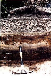
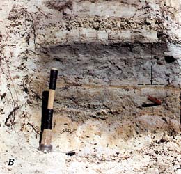
Figure 48. Tephra set B 8.5 km east-southeast of Mount St. Helens at a road cut along USFS Road N83,
0.5 km northeast of the Muddy River (measured section B-1). Tape bands on pickhandle are 10 cm wide. Photograph
taken in 1989. (96K)
|
This set is readily identified because of its overall dark color and its multiple
beds of scoriaceous lapilli; only the younger set X contains scoria, and it has only one lapilli layer that is
thin. Set B is relatively strongly oxidized and appears weathered overall, but a weathering profile was recognized
only at the top of the set.
|
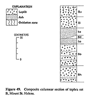
Figure 49. Composite columnar section of tephra set B, Mount St. Helens. (11K)
|
Set B is associated with ubiquitous mafic ash beds that are below, between,
and above the named tephra layers. Many of those beds surely are tephra, ejected during early and late stages of
eruptions of described layers, but they are not known to be distinctive and are not described separately.
Composition
Set B consists mostly of andesite but also contains basalt and dacite. Moderately
to highly vesicular clasts of scoria and pumice dominate the set; lithic clasts are not abundant. All scoria strata
contain abundant olivine except the basal layer, which contains sparse olivine and abundant hypersthene and augite
(table 5). Ferromagnesian minerals in the dacitic layers are mostly hypersthene, and
lesser augite and hornblende (table 5). Chemical compositions range from about 64 percent
SiO2 in the dacite layers to about 47 percent SiO2 in the basalt at the top of the set.
|
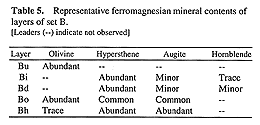
Table 5. Representative ferromagnesian mineral contents of layers of set B. (12K)
|
Diagnostic features
Its strong brown color and scoria content distinguish set B from other stratigraphic
units in almost all outcrops. Presence of scoria alone distinguishes it from older tephras and from all younger
tephras except set X. Multiple coarse scoria layers differentiate it from set X on all sides of the volcano except
the south and west. Even in the absence of scoria lapilli, the scarcity of olivine at the base of set B and the
presence of olivine without pyroxene in the upper part separate set B strata from those of set X.
Stratigraphic relations
Set B overlies set P and is separated from it east of the volcano by ash
bed v. On the west and northwest sides of the volcano, set B commonly overlies dacitic ash mineralogically similar
to that of set P but which may be of flowage origin. Set W tephra generally overlies set B east of a north-south
line through the volcano except toward the northeast, where Sugar Bowl deposits locally intervene between the two.
No evidence was found of a period of time between eruption of sets P and B
long enough for a soil profile to form. In contrast, the upper part of set B typically has been modified into a
relatively conspicuous soil that represents hundreds of years of exposure before it was buried by younger deposits.
Distribution and thickness
Set B crops out on all sides of the volcano. It is thickest from the northeast
to southeast, where it contains abundant lapilli and is 30-40 cm thick at distances of 8-10 km (fig.
50). In that sector, the set as a whole is about as thick as the underlying set P. Toward the south, set B
is about 30 cm thick at 6 km; farther to the west it thins and is only 15-20 cm thick at the southwest base of
the volcano. From southwest of the volcano clockwise around to the north, the set typically contains only one layer
of scoria lapilli but is as thick as 20 cm.
|
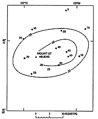
Figure 50. Thickness (in centimeters) of tephra set B, Mount St. Helens. Thickness is cumulative thickness
of strata interpreted as tephra; many stratigraphic sections also include interbedded deposits of flowage origin.
(9K)
|
Downwind, set B can be readily traced to distances of about 30 km toward the
northeast, east and southeast. Thin ash of set B also has been identified as far as 50 km to the east near Mount
Adams.
Age
Set B was erupted between about 2,500 and 1,600 radicarbon years B.P. No
radiocarbon material has been found at the base of the set. The older limiting age is judged from radiocarbon ages
in deposits of the next older Pine Creek period, which are as young as about 2,500 years. The oldest age from within
set B is about 2,200 years (sample W-2923, table 2), from dacitic pyroclastic-flow deposits
that overlie the two lower layers of the set.
A single radiocarbon date of about 1,620 years (sample W-2990, table
2) from above the upper layer of set B provides the younger age limit for the set.
Description of layers in set B
Stratigraphic positions and representative thicknesses of the named layers
in set B are given by figure 51 and measured section B-1. No outcrop exhibits all the
layers described. All but layer Bd do crop out, however, from northeast to the southeast near the volcano; layer
Bd was found only toward the north. The dacitic layer Bi conspicuously separates the lower and upper scorias of
the set east of the volcano.
|
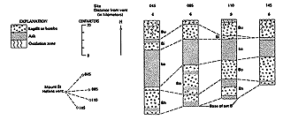
Figure 51. Columnar sections of tephra set B from northeast to south of Mount St. Helens and a diagram
of their locations relative to the central vent of the volcano. (18K)
|
Deposits of probable pyroclastic-flow, pyroclastic-surge and ash-cloud origin
are commonly interbedded with set B tephras, especially on the east and southeast sides of the volcano. Dacitic
pyroclastic-flow deposits also lie between lower and upper parts of the set on the northwest flank of the volcano.
Measured section B-1
Along USFS Road 83 0.5 km northeast of Muddy River, in NW1/4 NE1/4
sec. 20, T. 8 N., R. 6 E. See figure 48.
| |
|
Thickness (centimeters) |
| 5. |
Layer Bu. Lapilli and ash: dark, mostly brown;
dark gray in middle; chiefly ash at bottom and
top; lapilli as much as 3 cm across |
10 |
| 4. |
Layer Bi. Ash, light-yellow-gray; lapilli as large as about 5 cm across |
2-5 |
| 3. |
Ash bed ba: |
|
| |
Ash, mottled brownish-gray;, iron oxide stain at base
|
9 |
| |
Ash, dark-gray; subhorizontal iron oxide streaks
|
5 |
| 2. |
Layer Bo: |
|
| |
Lapilli, scoria; brown with gray interiors; openwork; clasts as much as 2 cm across
|
5 |
| |
Ash; in irregular, lenticular bed
|
1 |
| |
Lapilli, scoria, small; in coarse ash
|
4 |
| |
Ash, dark-brownish-gray, fine
|
1 |
| |
Lapilli, scoria, small; in coarse ash
|
3 |
| |
Ash, grayish-brown, fine
|
5 |
| 1. |
Layer Bh: |
|
| |
Scoria, lapilli and coarse ash, brown; clasts as large as 2 cm
|
4 |
| |
Ash, dark-gray
|
2 |
Measured section B-2
South valley wall of Ape Canyon Creek, about 50 m west of junction with Smith Creek valley wall, in SW1/4 NE1/4
sec. 5, T. 8 N., R. 6 E.
| |
|
Thickness
(centimeters) |
| 13. |
Colluvium |
5-20 |
| Set B: |
|
|
| 12. |
Ash, fine, dark-gray, lenticular |
3 |
| 11. |
Layer Bu. Small scoria lapilli as much as 4 cm across in sparse ash |
10 |
| 10. |
Ash, brown, fine |
3 |
| 9. |
Layer Bi. Ash, and pumice lapilli as much as about 3 cm across; lenticular, generally 5-10 cm thick |
8 |
| 8. |
Ash, brown, lenticular |
1-3 |
| 7. |
Lahar, bouldery |
35 |
| 6. |
Pyroclastic-flow deposit; bouldery lithic ash and lapilli |
15 |
| 5. |
Ash bed ba: |
|
| |
Ash, brown, fine
|
2 |
| |
Ash, dark-gray, coarse to fine
|
10 |
| 4. |
Layer Bo: |
|
| |
Scoria lapilli in ash, brown
|
3 |
| |
Ash, dark-gray
|
1 |
| |
Scoria lapilli in ash, brown: lenticular
|
3 |
| 3. |
Ash, brown |
1 |
| 2. |
Layer Bh: |
|
| |
Scoria lapilli and ash, dark-brown
|
1 |
| |
Ash, gray, fine
|
1 |
| |
Scoria lapilli and ash
|
6 |
| |
Ash, dark-gray: lenticular, 1-5 cm thick
|
5 |
| Base of set B |
|
|
| 1. |
Ash bed v |
11 |
Layer Bh
Layer Bh typically consists of a single bed of brown scoria lapilli but
locally toward the north and east includes two beds separated by ash. Where two beds were observed, the upper is
thicker and commonly is normally graded. Layer Bh contains little other than scoria and is relatively well sorted;
close to the volcano, open spaces between lapilli are noticeable. Ferromagnesian phenocrysts from the scoria are
chiefly hypersthene and augite (table 5). Olivine is sparse and was not found in all
samples examined. A single sample analyzed from the upper part of the layer contained about 58 percent SiO2.
This layer is locally coarser and better sorted than the others in set B, but
its identification depends almost completely on its stratigraphic position and on its ferromagnesian mineral suite
of hypersthene and augite, which is unlike that in any other scoria at Mount St. Helens.
Layer Bh overlies set P throughout its known distribution. East of the volcano,
it is separated from set P by the purplish-brown ash bed v. Layer Bh is overlain in most places by layer Bo scorias
but toward the north and northwest is locally overlain by the younger layer Bd or layer Bu.
Layer Bh was identified from northwest of the volcano clockwise around to the
south. It is thickest and coarsest toward the northeast, where it is as thick as 20 cm at a distance of 6 km. In
other directions from the northwest around to the southeast, it commonly is only 5-10 cm thick at distances of
6-8 km (figs. 50-52). Lapilli are common at those distances but bombs are rare. The layer was not traced more than
about 15 km downwind but surely extends at least a few tens of kilometers farther.
Layer Bo
|
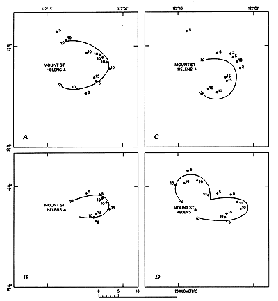
Figure 52. Thickness (in centimeters) of layers in set B, Mount St. Helens. A, Layer Bu. B, Layer Bi.
C, Layer Bo. D, Layer Bh. (24K)
|
Layer Bo is a relatively thick stratum consisting of several beds of brown
scoria lapilli and ash (fig. 48). In the field, it is strongly similar in appearance
to layer Bh. From the northeast to southeast flank of the volcano, layer Bo commonly has three or four discernable
beds or zones, each of which contains highly vesicular scoria lapilli and is separated from the others by thin,
dark ash (fig. 48). Although as many as four stratigraphic beds or zones can be recognized,
their vertical boundaries are poorly defined, and efforts to trace them as discrete units beyond a few tens of
meters were not successful.
Olivine is a major ferromagnesian constituent in all beds in layer Bo (table
5). In addition, pyroxene is present in samples from all beds of the layer tested but one. Both augite and
hypersthene are common, although their proportions vary widely. A chemical analysis determined the silica content
of a single fragment from layer Bo to be about 55 percent.
Abundant olivine in layer Bo distinguishes it from the underlying layer Bh,
and abundant pyroxene distinguishes it from the upper scoria layer Bu. The ferromagnesian mineral suite also distinguishes
layer Bo from all other tephras known at Mount St. Helens except those in set X. Olivine in layer Bo has generally
higher refractive indices than olivine in layers of set X, but stratigraphic relations may be required to satisfactorily
distinguish between them.
Layer Bo overlies layer Bh and is separated from it only by thin ash. Layer
Bo is overlain by ash bed ba, followed by younger layers of set B.
Coarse, lapilli-bearing layer Bo was identified on all sides of the volcano
except the northwest. It is thickest toward the southeast, where it is about 15 cm thick at 8-10 km from the volcano
(fig. 52). On the northeast and east, it commonly is 5-10 cm thick at 8-10 km. It was
traced for only about 20 km from the volcano but presumably extends much farther.
The several beds or zones in layer Bo, their varying content of ferromagnesian
minerals, and the distribution of the layer around the volcano suggest that the layer resulted from multiple eruptions.
During various eruptions, wind directions were different, and the tephra may even have come from more than one
vent. Even over distances of a few tens of meters, the number of recognizable beds in layer Bo changes markedly,
suggesting that wind or snow melt may have reworked these beds during or shortly after their deposition.
Dacitic tephra
Two dacitic tephra layers, Bd and Bi, are recognized in the middle of set
B. In addition, pinkish-gray to brown ash containing dacitic material is almost ubiquitous around the volcano in
stratigraphic position of the middle of the set and probably includes material derived from flowage events.
Layer Bd
Layer Bd is a single, thin bed of relatively dense pumice of small lapilli
and ash size that was found only on the north and north-northwest sides of the volcano. Its ferromagnesian mineral
suite consists of mostly hypersthene and small amounts of augite and hornblende. One chemical analysis of layer
Bd pumice indicates a silica content of about 64 percent.
Layer Bd is recognized by the relatively dense character of its constituent
pumice, by its distribution, and by its stratigraphic position between the lower scorias of the set and layer Bu.
The maximum known thickness of layer Bd is 5-10 cm on the pre-1980 north-northwest
flank of the volcano. Layer Bd was identified in the South Coldwater Creek valley about 10 km north of the volcano,
but its distribution farther to the north and in other directions is not known.
Layer Bd is similar in ferromagnesian mineral content and stratigraphic position
to nearby dacitic pyroclastic-flow deposits that are dated at 2,200-2,000 years old (Crandell, 1987). The tephra
layer probably is a product of small explosive events during dacitic eruptions that produced the pyroclastic-flow
deposits and is approximately the same age as those flowage deposits.
Layer Bi
Layer Bi is a single, well-sorted bed of highly vesicular white to yellow
pumiceous ash, lapilli, and a few small bombs (fig. 53). It crops out only from northeast
to southeast of the volcano. Its ferromagnesian minerals are chiefly hypersthene and lesser augite (table
5). This suite differentiates layer Bi from all other recognized tephras at Mount St. Helens. A single chemical
analysis shows about 64 percent Si02.
|
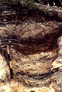
Figure 53. Tephra set B at a location where layer Bi is conspicuous, about 11 km east of Mount St. Helens.
Tape bands on pickhandle are 10 cm wide. (97K)
|
Layer Bi is usually easily recognized because it is the only dacitic tephra
that lies between set B scorias east of the volcano. Its identity can be easily confirmed by examination of its
ferromagnesian minerals. The layer lies directly above the upper part of ash bed ba and is overlain by the distinctive
layer Bu: no evidence of a time break at either horizon was seen.
In the sector from northeast to southeast of the volcano, layer Bi contains
abundant lapilli and is 10-15 cm thick at distances of 5-10 km. Downwind to the east, it diminishes rapidly in
thickness to about 1 cm at 20 km.
Radiocarbon ages of samples below and above layer Bi, from a peat bog 20 km
east of the volcano, indicate that the layer is approximately 1,800 years old (table 2,
samples W-2924, W-2925).
Layer Bu
Layer Bu is a widespread but thin layer of scoriaceous lapilli and a few
bombs in ash (figs. 49, 51). Locally it includes two discernible
lapilli beds or zones, but in most outcrops only one could be distinguished. Scoria of layer Bu is highly vesicular
and contains only olivine as an abundant ferromagnesian mineral. It is the most mafic of Mount St. Helens tephras
in that it contains only about 47 percent SiO2.
A soil profile that is virtually ubiquitous in the top of set B is developed
mostly in layer Bu. As a result, the upper part or even all of the layer generally is part of a mixed soil zone
that locally contains carbonaceous particles.
The presence of olivine and the almost total absence of pyroxene separate layer
Bu from all other tephras known at Mount St. Helens except for one scoria bed in layer Bo.
Layer Bu forms the top of set B. From north of the volcano clockwise around
to southeast, layer Bu overlies the dacitic layers Bd or Bi and elsewhere overlies ash bed ba, layer Bh, or layer
Bo. It is overlain by layer D along a narrow zone toward the northeast and elsewhere by tephras of set W or set
X.
Layer Bu was found on all sides of the volcano except the west. It commonly
is at least 5 cm thick at distances of 5-10 km in most directions. The layer is thickest toward the southeast,
however, where it is as thick as 20 cm at a distance of 9 km. It was traced only a few tens of kilometers from
the volcano.
The distribution of layer Bu suggests that it was produced by repeated eruptions,
during which winds blew in almost all directions. An age of between 1,800 and 1,650 years old is indicated by dated
radiocarbon samples from below and above the layer (table 2, samples W-2527, W2924, W-2990).
Ash bed ba
A multibedded deposit of gray to brown ash is immediately above the lower
lapilli-bearing scoria layers of set B. The ash deposit consists of a lower, dark-brownish-gray unit (bed bab)
that grades upward into an upper, lighter colored grayish-brown zone (bed bag) (figs. 48,
51). The lower unit generally is coarser and better sorted than the upper. Each part
of the ash deposit is visibly stratified in some places, which suggests that each consists of many depositional
units.
Ash bed ba varies strongly in composition of rock particles and ferromagnesian
minerals. The lower unit consists mostly of material similar to that in the underlying layer Bo. The upper unit
contains both andesitic and dacitic material. The color difference apparently reflects accurately the compositional
difference.
Ash bed ba is readily recognized in the middle of set B from northwest of the
volcano clockwise around to the southwest (fig. 54). It is thickest from the northeast
to the southeast, where it commonly is as thick as 15 cm at a distance of 10 km.
|
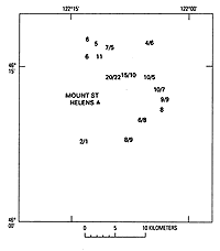
Figure 54. Thickness (in centimeters) of ash bed ba. Two numbers separated by a slash represent thicknesses
of the upper (bab) and lower part (bag) of the ash deposit, respectively. (7K)
|
This ash bed may have originated from more than one kind of event, including
small tephra eruptions. No tephra, however, was specifically identified within it. Lenticular crossbedding in the
ash in some places suggests that the deposit resulted at least in part from flowage events.