Scientific Investigations Map 3035
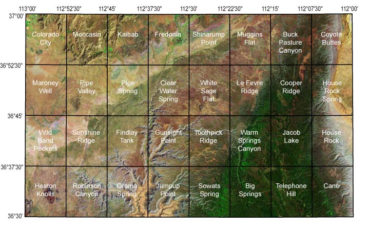
1:24,000-scale Maps of the Geologic Map of the Fredonia 30’' x 60’ Quadrangle, Mohave and Coconino Counties, Northern ArizonaThe database for the 1:100,000-scale Fredonia 30' x 60' quadrangle map was compiled from 32 1:24,000-scale maps. For clarity at 1:100,000-scale, some of the map units shown on the 1:24,000-scale maps were grouped together (see attached unit list) and some structural data were dropped; the database for the 1:24,000-scale maps is embedded in the 100,000-scale database. The full database is provided here in a large compressed file; fred-kp_db.zip (73.7 MB). The Fredonia metadata report describes both 1:100,000- and 1:24,000-scale map elements. Users can view metadata either embedded within the geodatabase or in ASCII format outside the database. The authors have generated geologic maps in PDF format of each of the 32 1:24,000-scale quadrangles. To view a 1:24,000-scale geologic map, click on a quadrangle in the index map below.
|
First posted December 10, 2008
For additional information, contact: Part or all of this report is presented in Portable Document Format (PDF). For best results viewing and printing PDF documents, it is recommended that you download the documents to your computer and open them with Adobe Reader. PDF documents opened from your browser may not display or print as intended. Download the latest version of Adobe Reader, free of charge. |
Billingsley, G.H., Priest, S.S., and Felger, T.J., 2008, Geologic map of the Fredonia 30' x 60' quadrangle, Mohave and Coconino Counties, northern Arizona: U.S. Geological Survey Scientific Investigations Map 3035, scale 1;100,000, https://pubs.usgs.gov/sim/3035/

![]() U.S. Department of the Interior |
U.S. Geological Survey
U.S. Department of the Interior |
U.S. Geological Survey
URL: http://pubsdata.usgs.gov/pubs/sim/3035/24k/24k_home.html
Page Contact Information: GS Pubs Web Contact
Page Last Modified: Thursday, 01-Dec-2016 17:12:44 EST