Scientific Investigations Map 3128
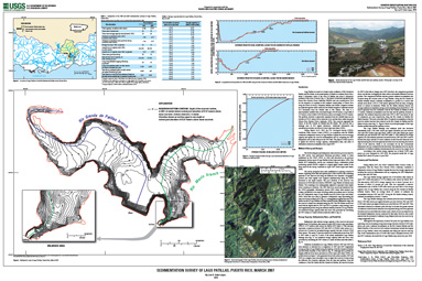
IntroductionLago Patillas is a reservoir located on the confluence of Río Grande de Patillas and Río Marín, in the municipality of Patillas in southern Puerto Rico, about 3 kilometers north of the town of Patillas and about 8 kilometers northeast of the town of Arroyo (fig. 1). The dam is owned and operated by the Puerto Rico Electric Power Authority (PREPA) and was constructed in 1914 for the irrigation of croplands in the southern coastal plains of Puerto Rico along the towns of Arroyo, Guayama, Patillas, and Salinas. Irrigation releases are made through the outlet works into the Patillas Irrigation Canal that extends 32.2 kilometers from the Patillas dam to Río Salinas. The dam is a semi-hydraulic earthfill with a structural height of 44.80 meters, a top width of 4.57 meters, a base width of 190.49 meters, and a crest length of 325.21 meters. The spillway structure is physically separated from the earthfill dam, has an elevation of 58.21 meters above mean sea level, and has three radial arm gates (Puerto Rico Electric Power Authority, 1979). The reservoir impounds the waters of the Río Grande de Patillas and Río Marín. The reservoir has a drainage area of 66.3 square kilometers. Additional information and operational procedures are listed in Soler-López and others (1999). |
First posted August 2010 For additional information contact: Part or all of this report is presented in Portable Document Format (PDF); the latest version of Adobe Reader or similar software is required to view it. Download the latest version of Adobe Reader, free of charge. |
Soler-López, 2010, Sedimentation Survey of Lago Patillas, Puerto Rico, March 2007: U.S. Geological Survey Scientific Investigations Map 2010–3128, 1 plate., available at https://pubs.usgs.gov/sim/3128/.

![]() U.S. Department of the Interior |
U.S. Geological Survey
U.S. Department of the Interior |
U.S. Geological Survey
URL: https://pubsdata.usgs.gov/pubs/sim/3128/
Page Contact Information: Contact USGS
Page Last Modified: Thursday, 01-Dec-2016 17:19:35 EST
