U.S. Geological Survey Scientific Investigations Map 3168
IntroductionIo, discovered by Galileo Galilei on January 7–13, 1610, is the innermost of the four Galilean satellites of the planet Jupiter (Galilei, 1610). It is the most volcanically active object in the Solar System, as recognized by observations from six National Aeronautics and Space Administration (NASA) spacecraft: Voyager 1 (March 1979), Voyager 2 (July 1979), Hubble Space Telescope (1990–present), Galileo (1996–2001), Cassini (December 2000), and New Horizons (February 2007). The lack of impact craters on Io in any spacecraft images at any resolution attests to the high resurfacing rate (1 cm/yr) and the dominant role of active volcanism in shaping its surface. High-temperature hot spots detected by the Galileo Solid-State Imager (SSI), Near-Infrared Mapping Spectrometer (NIMS), and Photopolarimeter-Radiometer (PPR) usually correlate with darkest materials on the surface, suggesting active volcanism. The Voyager flybys obtained complete coverage of Io's subjovian hemisphere at 500 m/pixel to 2 km/pixel, and most of the rest of the satellite at 5–20 km/pixel. Repeated Galileo flybys obtained complementary coverage of Io's antijovian hemisphere at 5 m/pixel to 1.4 km/pixel. Thus, the Voyager and Galileo data sets were merged to enable the characterization of the whole surface of the satellite at a consistent resolution. The United States Geological Survey (USGS) produced a set of four global mosaics of Io in visible wavelengths at a spatial resolution of 1 km/pixel, released in February 2006, which we have used as base maps for this new global geologic map. Much has been learned about Io's volcanism, tectonics, degradation, and interior since the Voyager flybys, primarily during and following the Galileo Mission at Jupiter (December 1995–September 2003), and the results have been summarized in books published after the end of the Galileo Mission. Our mapping incorporates this new understanding to assist in map unit definition and to provide a global synthesis of Io's geology. 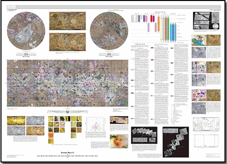
|
Files for viewing and printing:
Data:
For additional information: Part of this report is presented in Portable Document Format (PDF); the latest version of Adobe Reader or similar software is required to view it. Download the latest version of Adobe Reader, free of charge. |
Williams, D.A., Keszthelyi, L.P., Crown, D.A., Yff, J.A., Jaeger, W.L., Schenk, P.M., Geissler, P.E., and Becker, T.L., 2011, Geologic map of Io: U.S. Geological Survey Scientific Investigations Map 3168, scale 1:15,000,000, 25 p., available at https://pubs.usgs.gov/sim/3168/.

![]() U.S. Department of the Interior |
U.S. Geological Survey
U.S. Department of the Interior |
U.S. Geological Survey
URL: http://pubsdata.usgs.gov/pubs/sim/3168/index.html
Page Contact Information: GS Pubs Web Contact
Page Last Modified: Thursday, 16-Mar-2023 13:55:06 EDT
