![]()
Water-Resources Investigations Report 02-4149
The Scituate Reservoir system is the principal drinking-water supply for more than 60 percent of the population of Rhode Island. The system includes Scituate Reservoir and six tributary reservoirs the Ponaganset, Barden, Kimble, Westconnaug, Moswansicut, and Regulating Reservoirswith a total surface area of 7.2 square miles (mi2) and a maximum storage capacity of 40 billion gallons (fig. 1). The drainage basin contributing water to the system covers a 94 mi2 area and is primarily undeveloped forest land. The proximity of the basin to Providence, Rhode Island, and other major New England urban centers has led to recent increases in transportation and suburban development in many parts of the basin. This development has increased the potential for transport of contaminants to the water supply.
One potential source of contamination is the increased use of sodium chloride as a deicing agent on highways, local roads, sidewalks, and paved parking lots in the drainage basin. From 1983 to 1987, the mean sodium concentration in tributaries to the Scituate Reservoir increased from 7.9 to 19.8 milligrams per liter (mg/L), and the mean chloride concentration increased from 16.9 to 26.4 mg/L (Rhode Island Department of Administration, 1988). During the same period, sodium concentrations in the reservoir at the treatment-plant intake increased from 7.7 mg/L to a high of 9.3 mg/L in 1985, whereas chloride concentrations at the intake increased from 10.7 to 13.2 mg/L (Rhode Island Department of Administration, 1988). Because of the association of dietary sodium with hypertension, the U.S. Environmental Protection Agency recommends that sodium concentrations in drinking water not exceed 20 mg/L (U.S. Environmental Protection Agency, 1998). The National secondary drinking-water standard for chloride is 250 mg/L (U.S. Environmental Protection Agency, 2001). Both constituents are difficult and expensive to remove by conventional drinking-water treatment methods (Manahan, 1999).
In 1990, the Rhode Island Department of Transportation (RIDOT), in cooperation with the Providence Water Supply Board (PWSB), adopted the use of a 60:40 mixture of calcium chloride and sodium chloride, mixed with sand, in place of sodium chloride and sand, on State-maintained highways in the drainage basin. This practice was expected to reduce the sodiumapplication rate to these highways by approximately 40 percent, and thereby lower the sodium concentration in the water supply (Rhode Island Department of Administration, 1988). However, semiannual analyses of raw water from the treatment-plant intake indicate that the mean concentration of sodium in the reservoir has not decreased appreciably following implementation of this policy.
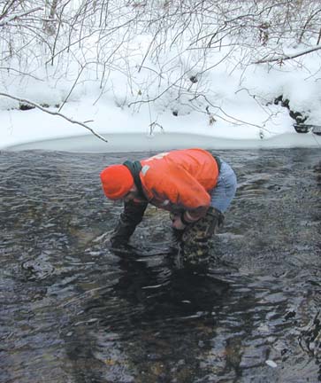 |
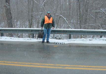
| U.S. Geological Survey hydrologist collecting water samples from a tributary to the Scituate Reservoir, Rhode Island. |
The U.S. Geological Survey (USGS) is cooperating with the PWSB, the agency responsible for managing the drainage basin and protecting the water supply, to develop a more complete understanding of the sources, transport mechanisms, and fate of sodium and chloride in the drainage basin. This report identifies the major sources of sodium and chloride in the Scituate Reservoir drainage basin and presents estimates of the amounts of these constituents that entered the basin during WY 2000.
Because road deicing was expected to be one of the most important sources, the effects of road density on sodium and chloride concentrations in tributary streams were examined using data collected from 1983 to 2000 by the PWSB at 31 monitoring stations located throughout the drainage basin. Road density was used as an indicator of the rate of application of road salt. Median sodium and chloride concentrations for individual streams during these 17 years were compared with 1995 road densities in the subbasins supplying the streams. Comparisons were made separately for data collected before and after introduction of the use of the reduced-sodium deicing agent on State-maintained roads in the basin.
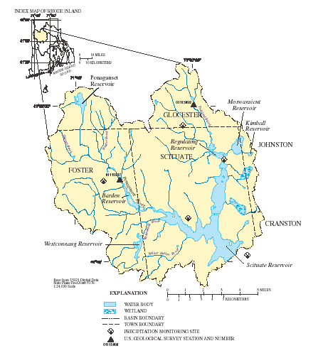 |
| Figure 1. Location and hydrography of the Scituate Reservoir drainage basin, Rhode Island. |
The Scituate Reservoir drainage basin is in northcentral Rhode Island, approximately 10 miles (mi) west of Providence. The basin includes most of the town of Scituate, and parts of Foster, Glocester, Johnston, and Cranston, Rhode Island (fig. 1). A large part (65.3 percent) of the drainage basin consists of undeveloped forest land. About 15 percent of the basin is developed, with residential (9.9 percent), commercial (0.5 percent), industrial (0.1 percent), institutional (0.2 percent), and agricultural (4.1 percent) land uses. The remaining land cover consists mainly of open water (7.5 percent) and wetlands (10.5 percent).
The topography of the drainage basin is characterized by steep slopes, rolling hills, and large rock outcrops. Slopes greater than 10 percent are found in about 20 percent of the basin (Breault and others, 2000). Soils generally are well-drained; poorly drained soils are found in only about 17 percent of the basin. Bedrock in the basin is composed primarily of Devonian and late Proterozoic igneous and metamorphic rocks and is overlain by glacial deposits consisting of till and meltwater deposits. Till covers most of the drainage basin, whereas meltwater deposits such as sand and gravel are limited to stream valleys and other low-lying areas (Breault and others, 2000).
The Ponaganset River, the principal stream in the basin, flows from its source at the Ponaganset Reservoir to its outlet at Barden Reservoir. The stream drains about 14 mi2 (15 percent) of the basin. Other major tributaries include Peeptoad, Windsor, Shippee, Westconnaug, and Wilbur Hollow Brooks, which drain about 21 mi2 (20 percent) of the basin (fig. 1). The USGS operates two continuous- record streamflow-monitoring stations in the drainage basin. During WY 2000, the annual mean discharges at the USGS continuous-record streamflowmonitoring stations on the Ponaganset River at South Foster, Rhode Island (01115187), and on Peeptoad Brook at Elmdale Road near North Scituate, Rhode Island (01115098), were 26.2 and 9.46 cubic feet per second (ft3/s), respectively (Socolow and others, 2001).
Sodium and chloride may enter the Scituate Reservoir drainage basin in precipitation, including wet and dry deposition, in salt applied during winter deicing of roads, highways, sidewalks, and parking lots, in leachate from unprotected road-salt supplies, and in leachate from individual sewage-disposal systems (ISDS) (fig. 2). In addition, sodium may be added by weathering of sodium feldspars in metamorphic and igneous rocks in the basin. Of these sources, wet deposition (precipitation), deicing activities, ISDS leachate, and geologic weathering were thought to be the most important. Amounts of sodium and chloride in dry deposition in forested drainage basins in the Northeast usually are small relative to those in wet deposition (Likens and Bormann, 1995), and all salt-storage facilities in the basin have been covered since the late 1980s (Rhode Island Department of Administration, 1988), so amounts added from this source should be minimal. Accordingly, dry deposition and saltstorage facilities were not considered in this study.
When sodium and chloride are deposited in a drainage basin in precipitation or during road deicing, a portion of the salt enters the tributaries directly in runoff, whereas the remainder infiltrates into the soil and then to ground water. Sodium entering soil and ground water may undergo cation exchange reactions, displacing calcium, potassium, magnesium, and other constituents from soil clays and organic particles, or it may move slowly with the ground water to eventual discharge points in tributary streams and reservoirs. Chloride generally moves more readily than sodium through the hydrologic cycle because it is relatively unreactive in most environments (Hem, 1985).
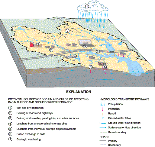 |
| Figure 2. Potential sources and transport pathways of sodium and chloride in the Scituate Reservoir drainage basin, Rhode Island. |
The rate of sodium transport in ground water depends, among other factors, on the cation-exchange capacity (CEC) of the soil and aquifer materials, and on the relative amounts of soil and rock in contact with the infiltrating water. Different subbasins in the Scituate Reservoir drainage basin may have different capacities for retaining sodium, depending on past road-salting practices, soil and rock CEC, and the proximity of roadways and other input sources to tributary streams.
The proportion of sodium that enters the ground water also depends on the presence or absence of impervious surfaces. Surfaces such as highways can convey salt-contaminated water directly to a stream, which readily transports the salt to the reservoirs. This is especially true of State-maintained roads, which frequently cross tributary streams.
During WY 2000, about 1,000 tons of sodium and 2,300 tons of chloride entered the basin or were released by weathering of soils and bedrock. Of these inputs, about 67 percent of the sodium and more than 90 percent of the chloride came from deicing of State highways, local roads, and other surfaces. Precipitation accounted for only about 7 percent of the sodium and 6 percent of the chloride inputs. About 15 percent of the sodium and 4 percent of the chloride came from ISDS leachate. Geologic weathering contributed about 11 percent of the sodium but was assumed not to be an important source of chloride. Because all ISDS leachate is discharged to ground water, the potential for interaction of dissolved constituents with soil and aquifer materials is high, and the time required for movement of mobile constituents may be very long (years to decades). Thus, the total estimated amounts of sodium and chloride released in ISDS leachate are not strictly comparable to those from inputs that are linked directly to surface water. The estimated total amounts of sodium and chloride that entered the drainage basin during WY 2000 from each major source are presented in table 1.
Salting of State-maintained roads contributed more sodium and chloride to the drainage basin during WY 2000 than did salting of locally maintained roads, although there were about 45 percent more total lanemiles of locally maintained roads (277 lane miles) than State-maintained roads (191 lane miles). Annual basinwide application rates calculated from these road-saltapplication values were 2.02 tons per lane mile for sodium and 8.03 tons per lane mile for chloride applied to State-maintained roads. For locally maintained roads, the average application rates were 1.06 tons per lane mile for sodium and 2.12 tons per lane mile for chloride. This difference may reflect the greater volume of traffic and higher speed limits on State-maintained roads.
|
Table 1. Major sources of sodium and chloride in the Scituate
Reservoir drainage basin, Rhode Island, October 1999 through September
2000 [--, contribution negligible] |
|||||||
|
|
|||||||
| Source Category |
Water Year 2000 Load (tons) |
||||||
|---|---|---|---|---|---|---|---|
| Sodium |
Chloride |
||||||
|
|
|||||||
| Precipitation......................................... |
75
|
140
|
|||||
| Salting of State-maintained roads........... |
390
|
1,500
|
|||||
| Salting of locally maintained roads......... |
290
|
580
|
|||||
| Other deicing activities......................... | 9 |
14
|
|||||
| Individual sewage-disposal systems....... | 150 | 88 | |||||
| Geologic weathering............................. | 110 | -- | |||||
|
|
|||||||
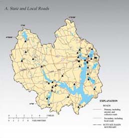
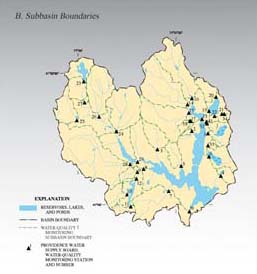
The importance of road-salting as a source of sodium and chloride in the Scituate Reservoir drainage basin prompted a more detailed examination of the relations between concentrations of sodium and chloride in tributary streams and deicing activities in the drainage basin. In 1995, there were 90.3 mi of State-maintained roads and 138.6 mi of locally maintained roads in the Scituate Reservoir drainage basin. Road locations relative to subbasins defined by 31 water-quality-monitoring stations used by the PWSB are shown in figure 3. Four additional stations in the the PWSB stream-water-qualitymonitoring network were considered unsuitable for this analysis, because they were excessively affected by highsodium ground water or by drainage from collecting basins for highway runoff.
The distinction between State-maintained and locally maintained roads was based on road-maintenance classifications in the RIGIS Statewide Road Inventory (Rhode Island Geographic Information System, 2001). State-maintained roads are State highways maintained by the RIDOT. Locally maintained roads include paved and unpaved public roads maintained by municipalities within the drainage basin. In addition, in 1995 there were about 83 mi of privately maintained roads in the drainage basin, but more than 80 percent of these were fire lanes and logging roads on land owned by the PWSB and protected from road-salting. Road lengths in each category were obtained and totaled for each of the 31 subbasins from the RIGIS Statewide Road Inventory and converted to lane miles. Subbasin-road densities were then calculated by dividing the number of lane miles in each subbasin by the area of the subbasin in square miles. Of the 31 subbasins examined, 26 had higher densities (more lane-miles per mi2) of locally maintained roads than State-maintained roads.
 |
 |
|
| Figure 3. Locations of Providence Water Supply Board water-quality-monitoring stations sampled from 1983 to 2000 in relation to (A) | State and local roads, and (B) subbasin boundaries in the Scituate Reservoir drainage basin, Rhode Island. |
The effects of road density on sodium and chloride concentrations in streams that contribute water to the Scituate Reservoir were examined by the use of sodium- and chloride-concentration data collected at regular intervals from January 1983 through December 2000 at each of the 31 the PWSB monitoring stations. Sodium data usually were obtained twice each year, in winter and summer, but some stations were sampled more frequently (up to six times per year). Water samples were collected by hand, usually in dry weather, when streamflow was essentially at baseflow. The total number of sodium samples ranged from 22 to 39 per station. Chloride data were obtained monthly at most stations. The total number of chloride samples ranged from 94 to 187 per station. In most cases, the roads cross the streams, and the monitoring stations are near the roads (fig. 3). Of the 31 stream-monitoring stations, 16 were associated with State-maintained roads, and 15 were associated with locally maintained roads.
Median stream-sodium concentration was positively correlated with the density of State-maintained roads in the subbasins (fig. 4). About 62 percent of the variation in median stream-sodium concentration was accounted for by the variation in density of Statemaintained roads. In contrast, no correlation could be identified between median stream-sodium concentration and the density of locally maintained roads in the subbasins. The relations between median chloride concentrations in the streams and the densities of State-maintained and locally maintained roads were similar to those for sodium. About 60 percent of the variation in streamchloride concentration was accounted for by the variation in density of State-maintained roads and no correlation (R2 = 0.002) could be identified between median streamchloride concentration and the density of locally maintained roads in the subbasins (fig. 5).
 |
| Figure 4. Relations between median stream-sodium concentrations during 19832000, and the density of State-maintained and locally maintained roads in 31 subbasins of the Scituate Reservoir drainage basin, Rhode Island. |
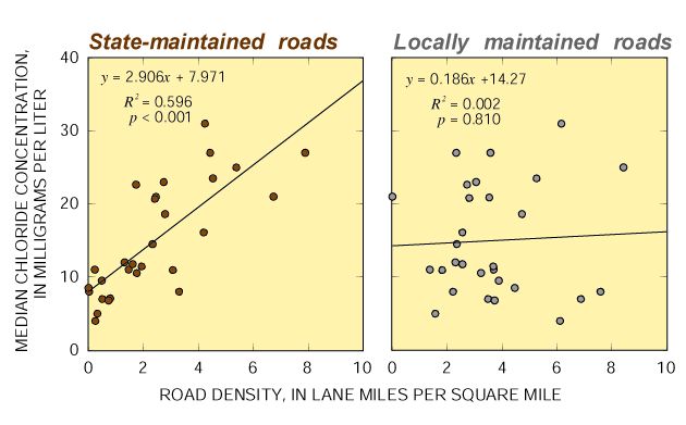 |
| Figure 5. Relations between median stream-chloride concentrations during 19832000, and the density of State-maintained and locally maintained roads in 31 subbasins of the Scituate Reservoir drainage basin, Rhode Island. |
When the sodium- and chloride-concentration data were divided into those collected in December through May (winter-spring samples) and those collected in June through November (summer-autumn samples), the median concentrations for the two constituents showed little seasonal variation. Likewise, there were no seasonal differences in the relations between median constituent concentrations and the densities of State-maintained and locally maintained roads. Because most of the samples were collected during dry weather, the immediate effects of runoff from winter storms probably are not represented in the concentration data. Rather, the winter-spring concentrations reflect the addition of sodium and chloride from road salt in melting ice and snow and the diluting effects of higher average flows during the period. The summer-autumn concentrations are more indicative of sodium and chloride levels in ground water, some of which undoubtedly is affected by salting of locally maintained roads. Ice and snow that accumulates along the sides of roads following plowing contains high concentrations of road salt, and slow melting of this material may contribute sodium and chloride to riparian aquifers as well as directly to the streams. Thus, although the sources of sodium and chloride that appear in the streams may be different in winter and summer, the combination of higher road-salt-application rates and more efficient drainage systems of State-maintained roads as compared to locally maintained roads, apparently makes the density of State-maintained roads a better indicator of conditions in the streams.
Various investigators have reported correlations between subbasin-road densities and concentrations of sodium and chloride in streams draining the subbasins. Runge and others (1989) found strong positive correlations between total subbasin-road densities and baseflow concentrations of sodium and chloride in streams in the Scituate Reservoir drainage basin, and Heisig (2000) reported similar results for chloride in small streams in the Croton River drainage basin in southeastern New York. Mattson and Godfrey (1994), used a multiple-regression model to predict sodium concentrations in Massachusetts streams and concluded that salting of interstate highways and State roads contributed more sodium to the streams than did salting of town roads. Breault and others (2000) calculated instantaneous loads (measured concentration of a constituent divided by the mean daily discharge on the day the stream was sampled) and subbasin yields (instantaneous load divided by subbasin-drainage area) of dissolved chloride for 34 subbasins of the Scituate Reservoir drainage basin during WY 1995. They concluded that subbasin road density, together with subbasin slope and wetland acreage, was a major determinant of dissolved chloride yield.
Road-salt application rates in the Scituate Reservoir drainage basin are not high when compared with those in other parts of the northeastern United States. The combined sodium and chloride application rate for all types of roads in the Scituate Reservoir drainage basin during 19992000 was 5.9 tons per lane-mile. Whereas this application rate is more than three times the rate estimated 1.7 tons per lane mile) by Runge and others (1989) for the same area during the early 1980s, it is lower than that reported by Heisig (2000) for the Croton River drainage basin (part of New York Citys water supply) during 199697 (18.5 tons per lane-mile of State, county, and local roads), and lower than the average application rate reported by the Massachusetts Highway Department 1997) for State-maintained and locally maintained roads in the drainage basin that supplies the city of Cambridge, Massachusetts, during 198693 (29 tons per lane mile).
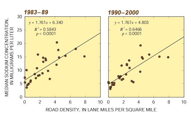
To determine the effects of the State-mandated introduction in 1990 of the use of a reduced-sodium deicing agent on State-maintained roads in the Scituate Basin, the relation between median stream-sodium concentration and subbasin-road density was determined separately for data collected from January 1983 to December 1989 and from March 1990 to April 2000. If the alternative deicing procedure was effective at reducing sodium loading to tributary streams, then the slope of the relation between sodium concentration and the density of State-maintained roads would be expected to decrease after 1990, indicating that the effect on stream-sodium concentration per treated lane-mile was reduced. However, there was no change in the slope of the regression line relating stream-sodium concentration and the density of State-maintained roads following the introduction of reduced-sodium highway-deicing practices in 1990 (fig. 6). These results are consistent with those of Breault and others (2000), who found significant decreasing trends in stream sodium concentrations in 4 of 34 Scituate Reservoir Subbasins examined from 1982 through 1995, but found no trends in sodium concentrations in the remaining 30 tributary subbasins.
There are several possible reasons for the apparent ineffectiveness of the use of a lower-sodium deicing agent on State-maintained roads. It may be that the reduction in sodium applications to State-maintained roads was offset by concomitant increases in applications elsewhere in the drainage basin. Increased development since 1990 has resulted in more locally maintained roads, more ISDS installations, and more private use of road salt. Alternatively, winter storms in recent years may have required larger applications of conventional road salt. It also is likely that there are large amounts of sodium adsorbed to clays and other soil particles beneath heavily salted roads and previously unprotected salt-storage facilities. Sodium leached from these soils would continue to migrate to the streams for some time (possibly years) after any change in the road-salt application rate.
 |
| Figure 6. Relations between median stream-sodium concentrations and the density of State-maintained roads in 31 subbasins of the Scituate Reservoir drainage basin, Rhode Island, during the periods 198389 and 19902000. |
Major sources of sodium and chloride entering the Scituate Reservoir drainage basin in Rhode Island during WY 2000 were identified and quantified by the U.S. Geological Survey, in cooperation with the Providence Water Supply Board, by the use of data from State and municipal public works departments, local precipitationmonitoring programs, State planning programs, and scientific literature. About 1,000 tons of sodium and 2,300 tons of chloride entered the basin or were released by weathering of soils and bedrock during the water year. Of these inputs, 67 percent of the sodium and more than 90 percent of the chloride came from deicing of State highways, local roads, and other surfaces in the drainage basin. Precipitation accounted for only about 7 percent of the sodium and 6 percent of the chloride inputs. Leachate from ISDS contributed up to 15 percent of the sodium and 4 percent of the chloride. Geologic weathering contributed about 11 percent of the sodium, but probably was not a major source of chloride.
Salting of State-maintained roads contributed about 35 percent more sodium and 159 percent more chloride to the drainage basin during WY 2000 than did salting of locally maintained roads, although there were 45 percent more lane miles of locally maintained roads than there were of State-maintained roads. On average, State highway-maintenance crews applied twice the amount of sodium and four times the amount of chloride per lane mile during WY 2000 than did municipal roadmaintenance crews, although application rates varied greatly from town to town within the drainage basin.
The effects of road-salt applications on streams that contribute water to the Scituate Reservoir were examined by the use of sodium- and chloride-concentration data collected by the PWSB at regular intervals from January 1983 through December 2000 at 31 tributary-streammonitoring stations in the Scituate Reservoir drainage basin. Median stream-sodium concentration was positively correlated with the number of lane miles of Statemaintained roads per mi2 of subbasin area. About 63 percent of the variation in median stream-sodium concentration was accounted for by variation in the density of State-maintained roads, verifying that salting of Statemaintained roads is an important source of sodium in the streams. In contrast, no correlation could be identified between median stream-sodium concentration and the density of locally maintained roads in the subbasins. Similar results were obtained for the relation between median stream-chloride concentration and road density.
 |
| U.S. Geological Survey hydrologist examines a highway storm drain during a winter storm in the Scituate Reservoir drainage basin. |
The effectiveness of a State-mandated use of a 60:40 mixture of calcium chloride and sodium chloride on State-maintained roads in the drainage basin beginning in 1990 was determined by comparing relations between subbasin road density and median stream-sodium concentrations for the periods 1983 through 1989 and 1990 through 2000. The slope of the regression line for these relations did not change following the introduction of the reduced-sodium deicing agent, indicating that there was no measurable change in the magnitude of the contribution of State-maintained roads to the sodium concentrations observed in the streams. The apparent lack of effect may be due to increased use of sodium chloride by municipalities and private individuals. The lack of effect may also indicate the mobilization of sodium previously applied and bound to soil particles.
Breault, R.F., Waldron, M.C., and Striker, L.K., 2000, Relations between water-quality conditions and drainage basin characteristics in the Scituate Reservoir drainage basin, Rhode Island, 198295: U.S. Geological Survey Water-Resources Investigations Report 00-4086, 46 p.
Coleman, S.M., and Dethier, D.P. (eds.), 1986, Rates of chemical weathering of rocks and minerals: Orlando, FL, Academic Press, 790 p.
Granato, G.E., Church, P.E., and Stone, V.J., 1995, Mobilization of major and trace constituents of highway runoff in ground water potentially caused by chemical migration: Washington, D.C., Transportation Research Board National Research Council, Transportation Research Record 1483, p. 92103.
Hammer, M.J., and MacKichan, K.A., 1981, Hydrology and quality of water resources: New York, John Wiley and Sons, 471 p.
Hem, J.D., 1985, Study and interpretation of the chemical characteristics of natural water (3d ed.): U.S. Geological Survey Water Supply Paper 2254, 263 p.
Heisig, P.M., 2000, Effects of residential and agricultural land uses on the chemical quality of baseflow of small streams inthe Croton Watershed, Southeastern New York: U.S. Geological Survey Water-Resources Investigations Report 99-4173, 15 p.
Likens, G.E., and Bormann, F.H., 1995, Biogeochemistry of a forested ecosystem (2d ed.): New York, Springer-Verlag, 159 p.
Manahan, S.E., 1999, Environmental chemistry (7th ed.): Boca Raton, FL, Lewis Publishers, 850 p.
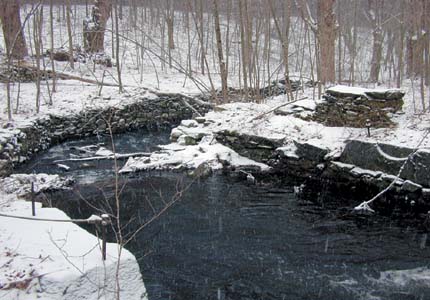 |
| Snow falling at an abandoned mill site off State Route 116 between Moswansicut Pond and Regulating Reservoir. |
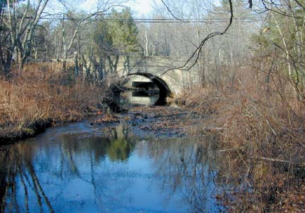 |
| Providence Water Supply Board water-quality monitoring station on Dolly Cole Brook, in South Foster, Rhode Island. The station is just downstream from State Route 6. |
Mattson, M.D., and Godfrey, P. Jos., 1994, Identification of road salt contamination using multiple regression and GIS: Environmental Management, v. 18, no. 5, p 767773.
Massachusetts Highway Department, 1997, Draft Environmental Impact ReportVolume 1. Hobbs Brook and Stony Brook Watersheds Highway Drainage Improvement Project: Boston, MA, EOEA Number 8263, variously paged.
Rhode Island Department of Administration, 1988, A road salt management strategy for the Scituate Reservoir Watershed: Providence, Rhode Island, Rhode Island Department of Administration, Division of Planning, Report Number 63, variously paged.
Rhode Island Department of Administration, 2001, Statewide Planning Program Web Site, accessed March 30, 2002, at URL http://www.planning.state.ri.us/SPC/RIPOP.htm .
Rhode Island Geographic Information System, 2001, accessed March 30, 2002, at URL
http:// www.edc.uri.edu/rigis-spf/statewide/state.html #transportation .
Runge, I., Wright, R.M., and Urish, D.W., 1989, Modeling sodium and chloride in surface streams during base flows: Journal of Environmental Engineering, v. 115, no. 3, p. 608619.
Socolow, R.S., Whitley, J.S., Murino, D., Jr., and Ramsbey, L.R., 2001, Water resources data, Massachusetts and Rhode Island, Water Year 2000: U.S. Geological Survey Water-Data Report MA-RI- 00-1, 459 p.
U.S. Environmental Protection Agency, 1998, Safe drinking waterSodium in drinking water, accessed March 30, 2002, at URL http://www.epa.gov/ safewater/ccl/sodium.html .
U.S. Environmental Protection Agency, 2001, Current drinking water standardsNational secondary drinking-water regulations, accessed March 30, 2002, at URL http://www.epa.gov/safewater/mcl.html .
Waldron, M.C., and Bent, G.C., 2001, Factors affecting reservoir and stream-water quality in the Cambridge, Massachusetts, drinking-water sources area and implications for source-water protection: U.S. Geological Survey Water-Resources Investigations Report 00-4262, 89 p.
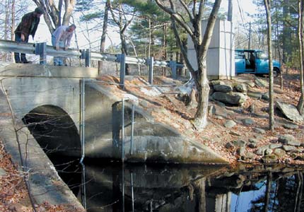 |
| U.S. Geological Survey continuous streamflow and waterquality monitoring station on Peeptoad Brook near North Scituate, Rhode Island. |
 |
| View of the Scituate Reservoir, Rhode Island, shoreline in early autumn. More than 60 percent of the reservoirs drainage basin is undeveloped forest land. |
|
U.S. DEPARTMENT OF THE INTERIOR |
| AccessibilityFOIAPrivacyPolicies and Notices | |
 |
|