Resources: The natural resources of our Nation are its land, water, minerals, and energy. These renewable and nonrenewable resources are needed to sustain life and to maintain and enhance our economic strength. USGS activities in the natural resources theme area inventory the occurrence and assess the quantity and quality of natural resources. Activities also include monitoring changes to natural resources, understanding the processes that form and affect them, and forecasting the changes that may be expected in the future.
Helping to Mitigate Acid Mine Runoff
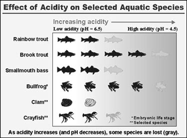
Over 400,000 abandoned mines are found on Federal lands. In addition, many more are adjacent to Federal lands or are affecting water quality and biological resources under Federal stewardship. Defunct mines have contaminated public and private lands with more than 50 billion tons of untreated mine waste. In the Appalachian coal region, acid mine drainage (AMD) has degraded more than 8,000 miles of streams and has left some aquatic habitats virtually lifeless. The cleanup and remediation of abandoned mine siteswill require a huge investment of taxpayers' dollars. In West Virginia alone, the coal industry is spending approximately $1 million each day to treat acid mine drainage.
USGS scientists are applying their knowledge and expertise to develop environmentally acceptable and cost-effective treatment processes for acidic, metal-laden drainage from abandoned coal mines. This restoration technology integrates fluidized bed reactors with carbon dioxide adsorption and desorption steps to circumvent problems that limit wide spread use of limestone as an acid neutralizing reagent. Field tests of the technology are currently being conducted in cooperation with the National Park Service, the Freshwater Institute, and the Pennsylvania State Department of Environmental Protection. Field tests include establishing the effects of the treatment process on acid-sensitive aquatic invertebrates and fish. Treating only a portion of the stream with super-treated effluent reduces the need for large, expensive equipment and decreases the costs of all aspects of the treatment process.
Microbiological Quality of Public Water Supplies
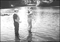
Sampling for microbes
|
In cooperation with the Missouri Department of Natural Resources, Public Drinking Water Program, the USGS sampled 109 public water supply (PWS) wells in 1998 to characterize the microbial activity of ground water in the Ozark Plateaus region. Much is known about bacterial contamination, but little is known about viral contamination and its relation to the bacterial and chemical characteristics of the ground water. Results of this study will provide State regulatory agencies with data needed to make informed decisions on treatment of potable ground-water supplies in the Ozark Plateaus and will provide useful and timely input to the U.S. Environmental Protection Agency for establishing ground-water disinfection rules for this type of carbonate aquifer system.
Preliminary results indicate that microbiological contamination of PWS wells in the Ozark Plateaus is not widespread. A USGS Fact Sheet describing the cooperative study and presenting the results of the first round of sampling is available on the USGS Missouri District home page at http://wwwdmorll.er.usgs.gov/.
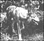
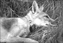
Swift Fox Range Expansion and Population Growth
|
Swift foxes, a species of the short-grass prairie ecosystem, have suffered major population declines. (The current status of the swift fox is a candidate species with a "warranted but precluded" recommendation for listing as endangered [Federal Register, U.S. Fish and Wildlife Service,
Ecological Services, Pierre, South Dakota].)
Factors limiting expansion of swift foxes into unoccupied portions of their historical range are unknown, but availability of suitable habitat and scarcity of food historically have been suggested as possible limiting factors. Instead, preliminary findings of current research at USGS suggest that interspecific competition with red foxes may be preventing swift foxes from pioneering into areas with suitable habitat. Interspecific competition could seriously compromise management being proposed for the conservation of swift fox. Attempts to translocate swift foxes to new areas could be extremely difficult or impossible if large populations of red foxes reside in areas considered for translocation projects. Where coyote management is being contemplated to enhance survival of swift foxes, it is important to understand the relationships between these canids. In many situations, control of coyotes will enhance distribution and abundance of red foxes and thus, negatively affect swift fox populations. The conflict between the swift and red foxes has potential for greater impact than the conflict between swift foxes and coyotes. Without understanding interspecific relationships, we risk ineffective or possible failure of management programs, loss of time and funds, and the conservation of the species may be compromised.
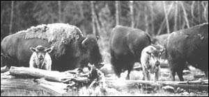
Bison and Brucellosis in the Greater Yellowstone Area
The successful long-term management of bison and brucellosis in the Greater Yellowstone Area
is influenced by many issues relating to bison population ecology and the epidemiology of brucellosis. In an effort to develop a more comprehensive understanding of these issues, USGS scientists are leading a collaborative effort with university, State, and Federal groups involving a number of studies. Ecological studies focus on forage availability, habitat use, and bison population dynamics. Brucellosis research includes examining the risk of transmission of the disease from wildlife to cattle, identification of exposed animals in the field, and the safety of vaccines to wildlife species. The information gained from these studies assists Park managers, Federal and State officials, Congress, and others in developing future bison management plans. For example, preliminary data are being used to project the outcomes of various management alternatives identified in the Draft Environmental Impact Statement for the Interagency Bison Management Plan for the State of Montana and Yellowstone National Park.
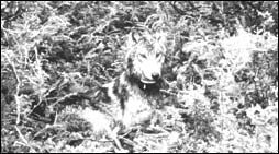
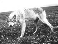
Dynamics of Wolves and Their Prey in Denali National Park
Management of wolves and their prey is currently a major National environmental issue with recovery of threatened and endangered wolf populations in the western U.S. In Alaska, the contentious wolf management debate continues, and Federal land managers are playing a larger role because of subsistence management responsibilities. USGS scientists are studying the population dynamics of wolves and their major prey species, caribou and moose, in Denali National Park. This research will aid managers in understanding fluctuations in wolf and prey populations and in making predictions of future population trends necessary for harvest management and reestablishment of wolf populations. The USGS collaborated with co-authors from the National Park Service to publish a book in 1998 entitled "The Wolves of Denali." This volume is a summary of the most comprehensive study of wolves and their prey ever available and includes important information for students, researchers, and managers.
Ground-Water Resources, Deschutes Basin
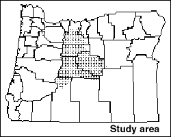
Study area of ground-water resources in the Deschutes Basin
|
USGS has worked in cooperation with the Oregon Water Resources Department, Deschutes and Jefferson Counties, the Confederated Tribes of the Warm Springs Reservation, and the cities of Bend, Redmond, and Sisters, on a project to evaluate the ground-water resources of the Deschutes Basin in Oregon. Data collected and computer simulations for this study have removed much uncertainty about regional ground-water/surface-water relations. Information from USGS studies has allowed State regulators to act on water-right applications in a manner that is more technically sound than methods used previously. A reassessment of ground-water policy in the basin, brought about in part by USGS project results, is presently underway by the Oregon Water Resources Department. In addition, USGS project staff have been interviewed by local news media on several occasions, resulting in numerous newspaper articles and segments on local news channels. This frequent interaction with the news media has significantly increased public awareness relative to water resources issues in the Upper Deschutes Basin.
Water Banking, Rialto Colton Basin
A ground-water investigation, in cooperation with the San Bernadino Valley Municipal Water District in the Rialto Colton Basin of San Bernadino County, California, has showed that artificial recharge ponds operated by the Municipal Water District are isolated from the main ground-water system by a previously unmapped fault. As a result of these findings, the Municipal Water District has ceased the recharge operations at these facilities.
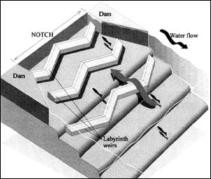
Little Falls Dam -- Resolving a Fish Passage Issue
The Fish Passage Team at the Center's Conte Anadromous Fish Laboratory has worked with a consortium of Federal agencies within the Washington, D.C. area to develop an effective fish passage design for the Little Falls Dam. The dam, located on the Potomac River about six miles below the District, is an example of one of the numerous low head dams in the U.S. that is blocking migration of fish species. To provide effective fish passage, the design of a new passage structure would not only have to permit fish, such as shad, to pass upstream, but had to satisfy requirements for boaters and also maintain the head of water behind the dam for major Capital district buildings such as the White House and the Pentagon. The basic accepted design completed by the Conte Staff was a notch in the dam with an inclined plane (lower river side), including a unique labyrinth on the plane which would permit fish passage, but also maintain the dam water-head and not be a danger to boaters. The Corps of Engineers will start to install the Conte design work during the 1998 summer period. When in place, the fish passage will provide an enhanced fishing experience for area visitors and residents.
Scientific Framework for Decision Support Systems
In cooperation with ESRI, Inc., the USGS recently completed a new Geologic Information Systems (GIS) decision support system designed to operate on the World Wide Web, and produced demonstrations of the product for examining resources in Alaska and for evaluating abandoned mine lands in Montana. The Alaska product has been released via CD-ROM and the Montana products are about to be released. These products were derived from an ongoing 5-year project to disseminate electronically the National and regional databases of geochemistry, geophysics, mineral and mine localities, and lithology, as well as extensive science applications developed using the data. These applications support policy and regulatory decisions and provide scientific background for land management, environmental assessment, and resource inventories. For example, data layers describing existing wetlands, weathering properties of ore-bearing rocks, and location of mine tailings can be combined to help plan for relocation of tailings (mining residue) away from water sources. Rapid access to data meets the needs of our partners and customers, including the Bureau of Land Management, US Forest Service, National Park Service, and States, for real-time access to data in formats they can use for interactive analysis in support of planning, remediation, and the full spectrum of land use and management decisions.
National Oil and Gas Resources
USGS petroleum research has been prioritized to improve our understanding of oil and gas occurrences and to reduce the uncertainties associated with oil and gas resource estimates. For example, the North Slope of Alaska is believed to have the greatest oil potential of any onshore area of the United States, and the USGS is conducting an intensive reexamination of the geology and petroleum potential of that region. The initial focus of this effort is the eastern North Slope, which includes the coastal plain of the Arctic National Wildlife Refuge (ANWR). This work will produce the most up-to-date and comprehensive analysis of the oil and gas potential of the ANWR coastal plain and will produce a digital base of information that will facilitate land use and environmental decision making by the Federal Government. The ANWR effort will be completed in FY 1998, although the overall North Slope project will continue for several years as the focus of research shifts westward to areas that include the National Petroleum Reserve in Alaska (NPRA).
Federal-State Cooperative Program -- Bridge Scour Studies
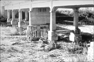
Example of bridge scour
|
Because of increasing National concern about the safety of highway bridges subject to scour, Departments of Transportation in all States have been mandated to complete scour assessments on all Federally funded highway bridges. Complete scour assessments require fairly complex hydraulic analysis that are expensive and time
consuming. USGS hydrologists in Montana, in cooperation with the Montana Department of Transportation (DOT), developed a method for rapidly estimating bridge scour depth based on limited, easily measured data that could be applied to a large number of sites in a fairly short time. The method is based on data from similar USGS studies in 10 States. USGS subsequently used the method to estimate scour depths at over 1,500 bridges in Montana, thereby greatly helping the Montana DOT to meet the National deadline for preliminary scour assessment. This study provided the Montana DOT with scour assessments on a timely basis that could not have been completed using conventional methods. In 1998, the rapid-estimation method has been used by USGS offices in other States to help State DOT's meet National deadlines and help ensure public safety. Cost savings to the State agencies are estimated to have been substantial.
Stream Bank Erosion
During 3 years of investigating stream bank erosion in cooperation with the Alaska Department of Fish and Game, the Alaska Department of Environmental Conservation, and the Lake and Peninsula Borough, USGS hydrologists discovered that, during below normal flow years, as much as 97 percent of annual bank erosion is caused by boat wakes. In addition, areas of rivers that do not typically experience significant erosion, such as the inside of meander bends, have been undercut more than 4 feet during a single season of boat traffic. Even remote rivers with low numbers of boats, such as the Alagnak River in southwestern Alaska, experience substantial stream bank erosion induced by boat wakes. Accelerated bank erosion may degrade important habitats and threaten Alaska's economically valuable salmon resources. The results of the studies will be used to manage recreational activities on rivers in Alaska.
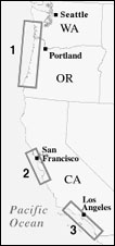
Coastal & Marine Geology
As part of its response to El Niño and its coastal storms, the USGS and its Federal partners collected baseline data in October 1997 on the exact location of coastal features. The USGS, NOAA, and the National Aeronautics and Space Administration surveyed more than 1000 kilometers of coastal Washington, Oregon, and California using an advanced, high-resolution, laser-based topographic surveying system. These areas will be resurveyed after El Niño to document physical changes caused by the event. In addition, the USGS and State, local, and university cooperators are monitoring shoreline change at established coastal sites. Monitoring at a previously established ocean current and sediment network in central California has been extended through the El Niño event. These studies provide the basis for anticipating the threat posed by extreme climate events.
|

1
|

2
|
3
|
|
Extent of surveys measuring the effects of El Niño storms on the Pacific coast...Triangles along the above coasts were locations of these surveys.
|
|
|
|
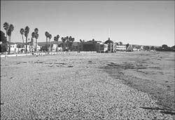
Main Beach, Santa Cruz the day after Christmas 1997, showing a wide beach early winter before the onset of heavy El Niño storms.
|
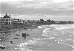
El Niño winter conditions at Main Beach, Santa Cruz near the Boardwalk February 6, 1998, showing dramatic effects of storms causing extensive coastal erosion.
|
PREVIOUS || TABLE OF CONTENTS || NEXT
This page is https://pubs.usgs.gov/98financial/resources.html
Maintained by Eastern Publications Group Web Team
Last updated July 6, 1999