Environment: Our Nations environment the air, water, soil, and plant and animal life is constantly changing as natural processes and human actions affect it. USGS activities in the environment theme area include studies of natural physical, chemical, and biological processes, and of the results of human actions; the goal is to provide the understanding and scientific information needed to recognize and mitigate adverse impacts and to sustain the environment. Activities include data collection, long-term assessments, ecosystem analysis, predictive modeling, and process research on the occurrence, distribution, transport, and fate of contaminants, as well as the impacts of contaminants on plant and animal life.
Climate-Driven Vegetation Changes
The USGS, in cooperation with University of
Oregon and Colorado scientists, has determined the range of climate factors that control the distribution of vegetation in the western U.S., including specific types of trees and scrubs. This information has been organized into a database and conceptual model that can be used to gain insights into changes in vegetation that might occur under different climatic conditions. Knowledge of such changes is of critical importance to long-term management decisions made by DOI, Natural Resources Conservation Service (NRCS), State, forestry, and other land use planners. This knowledge gained by scientific models and experiments demonstrate that the effects of climate change are complex, and point to the need for developing capabilities to test and refine the projections and impacts of future changes.
Burrowing Saves Lake Erie Clams
Freshwater clams in North America have been virtually eliminated from water that is colonized by the exotic zebra mussels. Near total mortality has been reported in western Lake Erie, but USGS biologists have discovered a large
population of native clams in a Lake Erie wetland (Metzger Marsh) that shows little sign of infestation. Field observations and laboratory experiments show that soft sediments trigger burrowing by clams. This discourages infestation and physically removes any attached zebra mussels. These results provide promise that at least some clams are using the wetland as a refugium, and that the clams may be available to recolonize Lake Erie if zebra mussel populations ultimately decline.
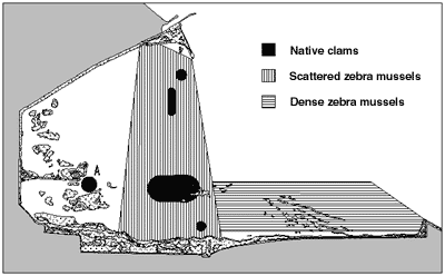
Aerial view of native clams in Lake Erie wetland that shows little sign of infestation.
|
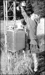
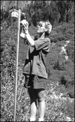
Mt. Rainier Air Pollution Findings
Recent studies by USGS scientists and students have shown that Mt. Rainier National Park is the most polluted area of Washington State in terms of tropospheric ozone. This colorless gas is formed from nitrogen oxides and organic compounds, common components of fossil fuel emissions, in the presence of sunlight. It is highly
toxic to both humans and vegetation at very low concentrations. Pollutants produced in the Seattle-Tacoma metropolitan area are transported eastward toward the Cascade Range, where Mt. Rainier is directly in the path of the pollutant plume. Weekly average concentrations of ozone are actually higher in the Mt. Rainier regions than
they are in the Seattle area, with the highest exposures at high elevations up to 8,000 feet. Ozone synthesis is enhanced by warm, sunny weather, so rural residents, recreational visitors, and alpine
vegetation are exposed to potentially harmful levels of ozone during the summer when park visitation is highest and plants are metabolically active. As the human population of the Seattle-Tacoma region continues to increase and more motorized vehicles crowd local highways, air pollution levels can be expected to increase as well. Ongoing cooperative work between USGS scientists and the National Park Service will provide an early warning to future changes in air quality and the health of sensitive plant species in Mt. Rainier National Park.
|
|
|
USGS scientist collecting air quality samples at Mt. Rainier National Park.
|
|
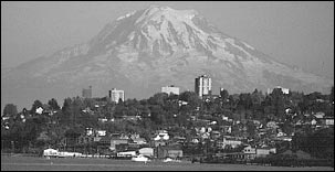
Mt. Rainer, USGS photo by Lyn Topinka.
|
|
USGS Data Help Determine Cause of Fish Disease Outbreak in Southeast Florida
Historical flow data from two long-term stations, the Caloosahatchee Canal discharging to the west coast and St. Lucie Canal discharging to the east coast, are being used by the Florida Department of Environmental Protection (FDEP) to examine the correlation of low salinity to recent outbreaks of fish disease. Historical data from the St. Lucie Canal will be used to examine the frequency of this year's high, El Ni�o related discharges and to determine if previous outbreaks of fish disease were related to periods of high flow. Historical discharges from both stations will be compared and used to determine why fish disease outbreaks are apparently confined to the east coast. Results of these analysis were presented by FDEP staff at a town meeting in Stuart, Florida on April 21, 1998.
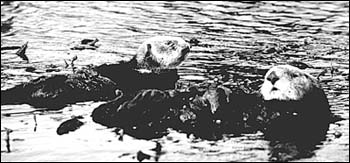
Further Decline in Southern Sea Otter Population
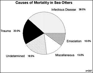
Miscellaneous category = causes of mortality were determined, but the percentage of the population was so small thay they were lumped together into one category.
|
California's threatened southern sea otter population has not increased since 1994. At the request of the U.S. Fish and Wildlife Service (FWS), USGS pathologists have been determining the causes of mortality of southern sea otters. To date, findings have shown that California sea otters have an unexpectedly high mortality from infectious diseases. The variety and frequency of the diseases led USGS pathologists to suspect that something may be suppressing the sea otters'
immune systems, making them more vulnerable to infectious diseases. Tissues from a subset of dead adult otters were analyzed for two classes of aquatic contaminants known to suppress animal immune system. The chemical analyzes revealed that tissues from southern sea otters have high concentrations of one of these known contaminants. While USGS's results show that the southern sea otter population has high rate of mortality caused by infectious disease and that the population is being exposed to some classes of immune suppressive marine contaminants, no direct cause-and-effect linkage has been made. This information was presented to the Southern Sea Otter Recovery Team at their March 1998 meeting. The information will help Recovery Team biologists determine where to focus future sea otter research.
Ash Meadows Habitat Restoration
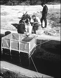
USGS scientists at Ash Meadow Wildlife Restoration site.
|
Ash Meadows National Wildlife Refuge is the home of three Federally listed endangered fishes and one Federally listed aquatic insect. These species have declined in number and distribution because their aquatic environment has been greatly altered by man and invaded by non-native fishes. USGS scientists have researched the habitat use, life history, and interspecific interactions of the indigenous species with non-native fishes. This information is being employed by the U.S. Fish and Wildlife Service to restore stream habitat on the Ash Meadows National Wildlife Refuge. USGS scientists assisted in the design of stream
habitat that favors the Federally listed native over non-native species. The results of the research and stream restoration will lead to the delisting of four Federally listed species.
Pesticides in the Willamette River Basin
In January 1998, USGS released a report describing Phase III of the Willamette River Basin Water Quality Study, a cooperative study with the Oregon Department of Environmental Quality (DEQ). The report describes pesticide concentrations and other water-quality considerations in small watersheds in the Willamette Basin that have intensive upstream agricultural or urban land uses. Streams in these watersheds have somewhat higher pesticide concentrations and more exceedances of water-quality criteria for bacteria and temperature than larger streams studied previously. The report has had an impact on State decision making because the DEQ is required to list water-quality-limited streams under the Clean Water Act and has, until now, focused on larger streams in the basin that typically have more data. Several other repercussions of the study include: (1) a recommendation in a report by the Governor's Task Force on the Willamette River, to implement many land-use practices that could reduce pesticide occurrence in streams; (2) inclusion of USGS at a Town-Hall style meeting with the Governor at the State Capitol Building, to discuss water-quality issues in the Willamette; (3) use of data by entities considering the Willamette River for a drinking water source; (4) impetus for debate and introduction to the legislature of a pesticide use reporting law; (5) use of the study's findings by local watershed councils to help decide on watershed management issues; and (6) the Oregon Department of Transportation's decision to investigate pesticide runoff from vegetation management along rights-of-way.
Lake Trout Restoration in Lake Superior
USGS biologists, working closely with State and tribal fishery management agencies, demonstrated that the survival of hatchery-reared lake trout stocked by the U.S. Fish and Wildlife Service has declined over the past 20 years. Results of this work led to the decision to end stocking throughout most of Lake Superior and place greater emphasis on protecting wild stocks to further lake trout restoration. This combined science and
management approach is now being adapted to restore lake trout in the other Great Lakes as well as to other native species in all of the Great Lakes.
Improving Fish Health in the Chesapeake Bay
The USGS is contributing to the Bay restoration by participating in the multi-agency Chesapeake Bay Program. USGS laboratories are conducting multi-disciplinary scientific studies to better understand Bay restoration issues and to assist resource management agencies in designing and implementing effective restoration strategies. USGS scientists, in cooperation with the State of Maryland, conducted analyzes of fish kill and disease events which suggest that fungi and bacteria may be the primary infectious agents that caused lesions in striped bass, white perch, bullheads, and other estuarine fish in the Bay. Non-point source run-off may be a factor in stimulating microbial infections. It is also likely that restoration of riparian zone vegetation is a solution to reduce non-point source pollution. In addition, USGS scientists are analyzing changes in land cover types in the Bay watershed over time and
linking these changes to nutrient and sediment loads. This information, along with other data collected by USGS and other agencies, will be invaluable for determining the effect of land use practices on the nutrients and sediments entering the Bay and their effects on water quality and living resource responses, including fish health. USGS works with more than 25 Federal agencies, as well as State and local agencies, universities, and private interest groups under the Chesapeake Bay Program. This multitude of Federal, State, and local agencies will use USGS information to support policy formulation and decision making for the restoration of the Bay. This information is especially in demand by land and resource managers as they develop management practices for future Bay restoration.
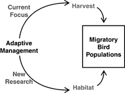
Adaptive Management of Waterfowl Populations
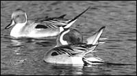
Northern pintail ducks
|
The USGS has an initiative to develop and implement new methods of determining how habitat conditions and hunting affect waterfowl populations. Models developed for adaptive management of hunting are revolutionizing Federal and State regulation of waterfowl hunting. In partnership with the U.S. Fish and Wildlife Service and other State and Federal resource managers, USGS scientists are expanding this innovative approach by developing scientific tools for designing effective conservation programs. The goal is to incorporate detailed habitat informant models for waterfowl, so that effects of both hunting and habitat management on waterfowl can be
evaluated.
PREVIOUS || TABLE OF CONTENTS || NEXT
This page is https://pubs.usgs.gov/98financial/environment.html
Maintained by Eastern Publications Group Web Team
Last updated July 6, 1999