Sustainability of Ground-Water Resources--Circular 1186
The effects of ground-water withdrawals on streamflow and spring discharge have become a major concern in parts of the Northwestern United States as continuing population growth increases the demand for water and pressures mount on the water resources to meet minimum instream-flow requirements for recreation and for fish and wildlife habitat. Examples from Washington and Idaho illustrate some of the complexities in how ground-water pumping affects surface-water resources.
A numerical model of a hypothetical basin in the Puget Sound Lowland of western Washington was used by Morgan and Jones (1999) to illustrate the effects of ground-water withdrawals on discharge to streams and springs in small basins typical of the region. The hypothetical basin shown in Figure C-1 consists of glacial deposits and alluvial sediments along streams that overlie low hydraulic-conductivity bedrock (see Figure C-2).
The results of three simulations are used here to illustrate the effects of pumping on streamflow for each of three different locations of water withdrawal from a well: (1) the unconfined aquifer near stream segment A, (2) the unconfined aquifer about 6,000 feet from stream segment A, and (3) a confined aquifer near stream segment A that is separated from the unconfined aquifer by about 25 feet of low-permeability till. The pumping well in simulation 1 and that in simulation 3 have the same land-surface location. The three simulations (simulations 1-3) are for steady-state conditions; that is, the ground-water system has reached dynamic equilibrium with the pumping from the well. For each simulation, the percentage of the ground water withdrawn that comes from capture of discharge to streams and their associated springs is shown in Table C=1 for five stream segments labeled A to E in Figure C-1.
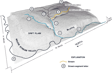
Figure C-1. Three-dimensional perspective view of a hypothetical basin typical of the Puget Sound Lowland showing topography, streams, and well locations for pumping simulations (Modified from Morgan and Jones, 1999.)
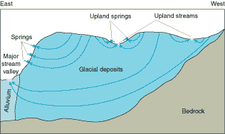
Figure C-2. Simplified hydrogeologic section for basin shown in Figure C-1 showing generalized ground-water-flow paths under natural conditions. Confining units and their effect on the flow system are not shown. (Modified from Morgan and Jones, 1999.)
At steady state, all of the ground-water withdrawal comes from capture of surface water for each of the three simulations. In looking at the distribution among stream reaches, virtually all of the captured water is from stream segment A when the water is pumped from a well in the unconfined aquifer near that stream segment (simulation 1). For a well located farther from stream segment A (simulation 2), most of the capture is still from stream segment A, but almost 25 percent of the capture is from the more distant stream segments B and E. Finally, if the water is withdrawn from the confined aquifer near stream segment A (simulation 3), about 50 percent of the capture comes from stream segment A, and the remainder comes from more distant stream segments.
The results illustrate that, because the effects of pumping propagate in all directions, several surface-water bodies can be affected by the water-level drawdowns caused by a pumping well. A well pumping from an unconfined aquifer will tend to capture most of its discharge from the nearest stream reaches. The presence of a confining layer between the well and the streams causes the cone of depression of the well to extend greater distances to capture the natural discharge required to offset pumping. Morgan and Jones (1999) demonstrated through additional simulations that, as the depth of the well and the number of confining layers increase, capture of discharge to streams and springs is distributed over increasingly larger areas.
| Table C-1. Streamflow capture along five stream segments for three pumping simulations: (1) pumping from well in unconfined aquifer near stream segment A, (2) pumping from well in unconfined aquifer about 6,000 feet from stream segment A, and (3) pumping from well in a confined aquifer near stream segment A | |||
|
|
|||
|
|
|
|
|
|
|
|
|
|
|
|
|
|
|
|
|
|
|
|
|
|
|
|
|
|
|
|
|
|
| *Sum of percentages for simulation 2 is less than 100 due to rounding. | |||
The previous example illustrates how capture of surface water might be distributed over a basin after equilibrium of the ground-water system has occurred. Computer simulations of the Eastern Snake River Plain aquifer by Hubbell and others (1997) illustrate how the effects of pumping on streamflow might be distributed through time before the ground-water system reaches equilibrium.
Highly permeable basaltic rocks of the Eastern Snake River Plain in Idaho provide conduits for rapid recharge of precipitation and water from extensive irrigation. Ground-water flow in this basaltic aquifer is primarily from northeast to southwest, as shown in Figure C-3. The aquifer is connected to the Snake River and discharges to the river largely through major springs, such as Thousand Springs at the downstream end of the flow system.
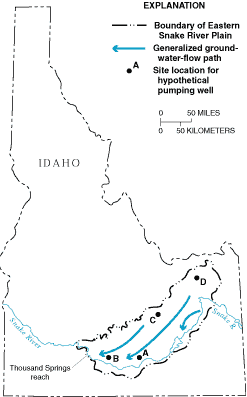
Figure C-3. Eastern Snake River Plain aquifer system. (Modified from Hubbell and others, 1997; reprinted with permission of the National Ground Water Association. Copyright 1997.)
The timing of the effects of pumping on spring discharge to the Thousand Springs reach and to the entire eastern Snake River were simulated for each of four potential well sites (sites A-D in Figure C-3). For simulations at sites A to C, pumping was simulated at a constant rate for 100 years. Figure C-4 shows the depletion of flow to the river as a percentage of pumpage during the 100-year simulation. The river losses from pumping at site A are 50 percent of the pumpage after 23 years and about 90 percent after 100 years. Slightly more than half of the river depletion caused by pumping at site A occurs along the Thousand Springs reach.
Pumping at site B, located much closer to the Thousand Springs reach, has almost 90 percent of the pumpage obtained from capture of spring flow after 10 years of pumping. Most of the losses are from the Thousand Springs reach; river flow in the other reaches is only slightly affected by pumping at site B.
Site C is more distant from the Snake River. Pumping at this location has little effect on flows to the river for more than 10 years; however, depletion continuously increases during the long period of continuous pumping. The river depletion after 100 years of pumping at site C is about 70 percent of the pumpage.
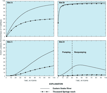
Figure C-4. Simulated losses to the Snake River resulting from pumping at well sites A to D. (Modified from Hubbell and others, 1997; reprinted with permission of the National Ground Water Association. Copyright 1997.)
The results of pumping at site D illustrate how surface-water depletion can continue long after pumping is discontinued at a well. These residual effects are demonstrated at site D by simulating continuous pumping for 30 years followed by a 70-year nonpumping period. Depletion of flow to the river increases for approximately 15 years after pumping at site D is discontinued. Depletion is still occurring 70 years after pumping ceases at a rate equivalent to 15 percent of the average pumping rate during the 30 years of pumping at site D.
The simulated results for sites A to D indicate that the location of a well relative to the ground-water-flow system has a significant effect on where changes in flow in the system take place and how long the system continues to adjust before equilibrium is reached. These results highlight the importance of taking transient response times of ground-water systems into account in long-term water-resources planning.