Sustainability of Ground-Water Resources--Circular 1186
Previous chapters have discussed the "ground-water-flow system," including recharge and subsequent flow of ground water through the system to areas of discharge, primarily bodies of surface water. In this context, the ground-water-flow system functions as a conduit that transports water, sometimes over considerable distances (miles, tens of miles), from areas of recharge to areas of discharge. In this chapter, the focus changes from the dynamic aspect of the ground-water-flow system to another aspect--the fact that the flowing ground water in the system represents a large, sometimes huge, volume of water in storage. In this context, it is appropriate to change terminology from "ground-water-flow system" to "ground-water reservoir," which emphasizes the storage aspect of ground-water systems.
A key feature of some aquifers and ground-water systems is the large volume of ground water in storage, which allows the possibility of using aquifers for temporary storage, that is, managing inflow and outflow of ground water in storage in a manner similar to surface-water reservoirs.
A change in the water level of any well (change in head) is a measure of a change in storage in the ground-water reservoir in the neighborhood of the open interval of the well. Thus, a rising water level in a well represents an increase in storage and a declining water level represents a decrease in storage in the ground-water reservoir. This situation is analogous to changes in water level in surface-water reservoirs. However, the relation between changes in water levels in wells and changes in the volume of water in storage is considerably more complex in ground-water reservoirs than in surface-water reservoirs (see Box A).
Even in aquifers and parts of aquifers that are not stressed by pumping wells, water levels in wells change continuously in response to changes in natural rates of recharge and discharge in the ground-water-flow system. Water levels in many wells exhibit an approximate annual cycle--water levels are highest during months of highest recharge, commonly the spring of the year, and lowest during months of lowest recharge, commonly the summer and early fall. In addition, large changes in recharge and discharge occur from year to year, which results in a potentially significant rise and decline in water levels during wet and dry years, respectively (Figure 17).
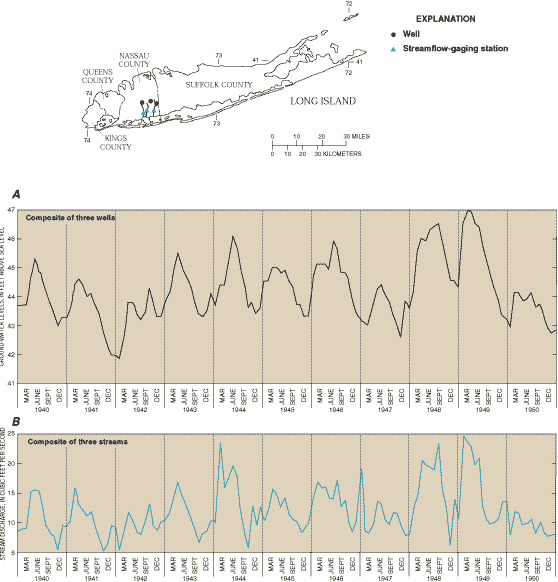
Figure 17. Composite average monthly (A) ground-water levels in selected wells and (B) discharge of selected streams in Nassau County, Long Island, New York for the period 1940-50. (Modified from Franke and McClymonds, 1972.)
The highly transmissive surficial deposits of sand and gravel, low relief, and humid climate of Long Island create ideal conditions for good hydraulic connection between the unconfined aquifer and numerous small streams. Before development more than 90 percent of total streamflow was derived from ground-water inflow; thus, these streams have been described as "ground-water drains." The good correspondence between ground-water levels in the unconfined aquifer and flow in nearby streams reflects the fact that in this ground-water system most of the streamflow is derived from ground water and there is good connection between the two systems.
Declines in heads and associated reductions in storage in response to pumping can be large compared to changes in unstressed ground-water systems. For example, declines in heads as a result of intense pumping can reach several hundred feet in some hydrogeologic settings. Widespread pumping that is sufficient to cause regional declines in heads can result in several unwanted effects. For example: (1) regional declines in heads may represent large decreases in aquifer storage, particularly in unconfined aquifers; (2) some wells may become dry because the lower heads are below the screened or open intervals of these wells; (3) pumping costs will increase because the vertical distance that ground water must be lifted to the land surface increases; (4) locally, the rate of movement of contaminated ground water and the likelihood that the contaminated ground water will be intercepted by a pumping well are increased; and (5) pumping of ground water may result in land subsidence or intrusion of saline ground water in some hydrogeologic settings. Because large and widespread changes in heads in aquifers are of interest to water managers and users of the ground-water resource, maps of heads (water levels) often are prepared periodically for individual, heavily pumped aquifers by water agencies. Comparisons of these synoptic-head maps permit changes in ground-water levels in wells to be documented through time for individual aquifers. Such histories of head change sometimes serve as the basis and catalyst for initiatives to manage the affected ground-water reservoir. The following examples illustrate aquifer response to pumping and associated changes in storage in different environmental settings.
High Plains aquifer--Let's first return to a previous example, the High Plains aquifer (see section on "Ground-Water Development, Sustainability, and Water Budgets"). Ground-water pumping from this unconfined aquifer has resulted in the largest decrease in storage of any major aquifer in the Nation. In parts of the central and southern High Plains, more than 50 percent of the predevelopment saturated thickness has been dewatered (see Figure 10B). The water table continues to decline under much of the High Plains. During the past two decades, however, monitoring of water levels in wells indicates an overall reduced rate of decline of the water table (McGuire and Sharpe, 1997). This change is attributed to improved irrigation and cultivation practices, decreases in irrigated acreage, and above normal precipitation during this period. In parts of the High Plains, water-level rises have occurred because of seepage losses from surface-water irrigation or the recovery of local cones of depression as a result of decreased pumpage.
Nassau County, New York--The response of an unconfined aquifer to stress in a humid climate that results from urban land-use practices is exemplified by the upper glacial aquifer on Long Island. It was noted previously that prior to installation of an extensive sewer system, a large proportion of the water pumped on Long Island for public supply and commercial use was returned to this unconfined aquifer by septic systems. After installation, water that formerly recharged the upper glacial aquifer from septic systems now was discharged directly into the ocean. This loss of recharge represented a significant change to the water budget of the ground-water system and resulted in a loss in storage of water in the upper glacial aquifer.
The effects of installation of the sewer system on aquifer storage in Long Island are reflected in the water-level record shown in Figure 18 for a well completed in the upper glacial aquifer in west-central Nassau County, an area where an extensive sewer system began operation in the early 1950s. The upper horizontal line in Figure 18 (water level equals 68 feet above sea level) represents an average water-table altitude at the well before installation of the sewer system. The fluctuations in water level around the average value represent a response to the annual cycle of recharge and evapotranspiration and the differences in this cycle from year to year. The sewer system achieved close to its maximum discharge by the mid-1960s for the existing population in the sewered area. The lower horizontal line (water level equals 54 feet above sea level) represents the average water level after the hydrologic system had adjusted to the effects of installation of the sewer system. The water-level fluctuations around the lower horizontal line again reflect annual recharge and evapotranspiration cycles.
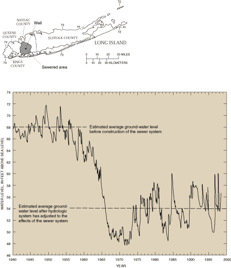
Figure 18. Water-level record for a well completed in the upper glacial aquifer in west-central Nassau County, Long Island, New York.
Installation of the sewer system has resulted in an areally extensive (several tens of square miles) loss of storage in the unconfined aquifer. The most obvious undesirable effect of the lowered water-table elevations has been marked decreases in the flow and length of small, ground-water-fed streams in the area. The positive effect of installing the sewer system has been to reduce recharge of contaminated water from septic systems and thereby help maintain the quality of shallow ground water and the deeper ground water that is hydraulically connected to the shallow ground water.
Chicago/Milwaukee area--The long history of ground-water withdrawals from the Cambrian-Ordovician aquifer in the Chicago and Milwaukee areas is a well-documented example of the effects of heavy pumpage on heads in a confined aquifer. The first documented deep well in the Chicago area was drilled in 1864 to a depth of 711 feet and flowed at the land surface at a rate of 400 gallons per minute. During the next decades and into the 20th century as the Chicago metropolitan area grew, the number of wells, the areal extent of pumping, and the total withdrawals from this aquifer increased substantially. Maximum withdrawals, about 180 million gallons per day, and maximum declines in heads of about 800 feet for the Cambrian-Ordovician aquifer, occurred in the eight-county Chicago area in about 1980 (Figure 19). Since 1980, many public water suppliers in the Chicago area have shifted their source of water from ground water to additional withdrawals from Lake Michigan. This shift has resulted in a significant decrease in total withdrawals from the aquifer and a general recovery (increase) of heads in the areas of decreased withdrawal (Figure 20). Pumping continues in all parts of the Chicago and Milwaukee area, however, and may be increasing in some parts, so that heads in some localities may still be decreasing.
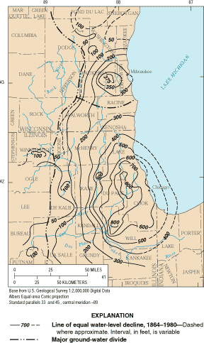
Figure 19. Decline in heads (water levels) in the Cambrian-Ordovician confined aquifer, Chicago and Milwaukee areas, 1864-1980. (Modified from Avery, 1995.)
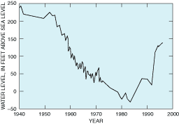
Figure 20. Representative trend of water levels for a deep well in Cook County, Chicago area, since 1940. (From Visocky, 1997.)
The volume of the cone of depression in the Chicago and Milwaukee area is large, even with the present decrease in withdrawal rates. A principal concern has been the possibility of beginning to dewater the confined aquifer and effectively convert it to an unconfined aquifer. This possibility was imminent at the center of the cone of depression in 1980 and was avoided by the subsequent decrease in withdrawal rates in this critical area.
The sustainability of confined aquifer systems like the Cambrian-Ordovician aquifer is typically controlled by the proximity of pumping centers to recharge and discharge areas or by the hydraulic connection with other aquifer systems. Walton (1964) defined the "practical sustained yield" of the Cambrian-Ordovician aquifer as the maximum amount of water that can be continuously withdrawn from existing pumping centers without eventually dewatering the most productive water-yielding formation. Using this definition, Walton estimated the practical sustained yield to be about 46 million gallons per day. He noted that with the existing distribution of pumping centers, the practical sustained yield was limited not by the rate of replenishment in recharge areas but by the rate at which water can move eastward through the aquifer from recharge areas. Walton estimated that the practical sustained yield could be increased more than 40 percent to about 65 million gallons per day by (1) increasing the number of pumping centers, (2) shifting centers of pumping toward the recharge area, and (3) spacing wells at greater distances.
In all but the deeply buried parts of the Cambrian-Ordovician aquifer in the Chicago and Milwaukee area, the water is chemically suited for all uses. Thus, water quality has not been a major factor affecting the use of this aquifer. Because of their greater depth, however, confined aquifers often contain saline water or are hydraulically connected to other aquifers and confining units that contain water with high dissolved-solids concentration. Declines in head in the confined aquifer can cause the movement of poor quality water from surrounding aquifers (or confining units), which may limit development of the aquifer more than declines in heads and aquifer storage.
Kings County, New York--The history of ground-water development in Kings County (Brooklyn), Long Island, New York since the early 1900s is a well-documented example of a complete cycle of intensive development with significant decreases in heads and reduction in storage in the unconfined aquifer accompanied by intrusion of saline ground water, followed by a decrease in total pumpage and a gradual recovery of heads. In 1903, total ground-water withdrawals in Kings County were about 30 million gallons per day. Available information on the altitude of the water table indicates no obvious cones of depression at this time (Figure 21). Total pumpage in Kings County peaked in the 1920s to early 1940s (maximum annual pumpage about 75 million gallons per day). As shown in Figure 21, water levels in 1936 were near or below sea level throughout Kings County, and the cone of depression extended into southwestern Queens County.
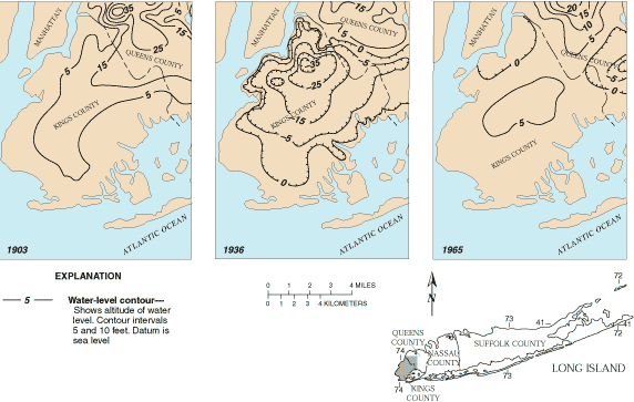
Figure 21. Water-table altitudes in Kings and part of Queens Counties, Long Island, New York in 1903, 1936, and 1965. (Modified from Franke and McClymonds, 1972.)
In 1947, public-supply pumpage ceased in Kings County. The source of water for public supply changed to the upstate surface-water system that supplies New York City through water tunnels. Furthermore, legislation was implemented during this period that required "wastewater" (including air-conditioning water) from some industrial/commercial uses be recharged to the aquifer system through wells. Concurrently, and partly as a result of these changes, industrial pumpage declined to a long-term stable rate of slightly less than 10 million gallons per day. These changes are reflected in the water-table map of 1965 shown in Figure 21 in which heads have risen throughout Kings County and are at or below sea level only in northern parts of the county. Subsequent maps show a small but continuing recovery of the water table.
The history of ground-water development in Kings County has been influenced considerably by the strong hydraulic connection between the unconfined ground-water system and the surrounding bodies of saline surface water. The decision to stop pumping for public supply and to recharge high-quality wastewater back to the aquifer system was driven in large measure by concerns about ongoing and continuing intrusion of saline ground water into the naturally fresh part of the aquifer system. On the other hand, an unforeseen and undesirable effect of decreased pumpage and the accompanying rise in the altitude of the water table in Kings County is that basements of major buildings constructed in the 1920s and 1930's now lie below the water table and require continuous pumping of dewatering systems to keep them dry.
Commonalities in the preceding four examples are noteworthy and include (1) the changes in storage resulted in observable changes in the ground-water system; (2) the changes in the ground-water system generally were viewed by local stakeholders as undesirable, at least to some extent; and (3) in at least three of the four examples, some response to mitigate the perceived undesirable effects of the change in storage was initiated. In examples such as the southern High Plains aquifer in Texas and New Mexico, and the unconfined aquifer in Brooklyn, New York, the long-term sustainability of the ground-water resource was perceived to be in jeopardy.
Land subsidence, which is a decline in land-surface elevation caused by removal of subsurface support, can result from a variety of human activities (Galloway and others, in press). Subsidence can severely damage structures such as wells, buildings, and highways, and creates problems in the design and operation of facilities for drainage, flood protection, and water conveyance. Human activities related to ground water cause land subsidence by three basic mechanisms: compaction of aquifer systems, dissolution and collapse of rocks that are relatively soluble in water (for example, limestone, dolomite, and evaporites such as salt and gypsum), and dewatering of organic soils.
Compaction of aquifer systems as a result of ground-water withdrawals and accompanying land subsidence is most common in heavily pumped alluvial aquifer systems that include clay and silt layers. As heads in the aquifer system decline due to pumping, some of the support for the overlying material previously provided by the pressurized water filling the sediment pore space shifts to the granular skeleton of the aquifer system, increasing the intergranular pressure (load). Because sand and gravel deposits are relatively incompressible, the increased intergranular load has a negligible effect on these aquifer materials. However, clay and silt layers comprising confining units and interbeds can be very compressible as water is squeezed from these layers in response to the hydraulic gradient caused by pumping.
So long as the intergranular load remains less than any previous maximum load, the deformation of the aquifer system is reversible. However, when long-term declines in head increase the intergranular load beyond the previous maximum load, the structure of clay and silt layers may undergo significant rearrangement, resulting in irreversible aquifer system compaction and land subsidence. The amount of compaction is a function of the thickness and vertical hydraulic conductivity of the clay and silt layers, and the type and structure of the clays and silts. Because of the low hydraulic conductivity of clay and silt layers, the compaction of these layers can continue for months or years after water levels stabilize in the aquifer. In confined aquifer systems that contain significant clay and silt layers and are subject to large-scale ground-water withdrawals, the volume of water derived from irreversible compaction commonly can range from 10 to 30 percent of the total volume of water pumped (Galloway and others, in press). This represents a one-time mining of stored ground water and a permanent reduction in the storage capacity of the aquifer system.
The first recognized land subsidence in the United States from aquifer compaction as a response to ground-water withdrawals was in the area now known as "Silicon Valley" in California. Other areas experiencing significant land subsidence from ground-water withdrawals include the San Joaquin Valley of California (see Box B), the alluvial basins of south-central Arizona (Figure 22), Las Vegas Valley in Nevada, the Houston-Galveston area of Texas, and the Lancaster area near Los Angeles, California.
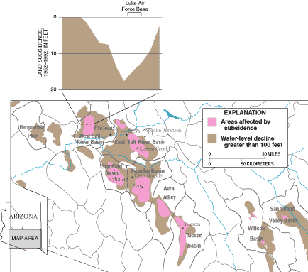
Figure 22. Land subsidence in south-central Arizona. (Modified from Carpenter, in press.)
Ground-water development for agriculture in the basin-fill aquifers of south-central Arizona began in the late 1800's, and by the 1940's many of the basins had undergone intensive ground-water development. Ground-water depletion has been widespread over these basins, and locally, water-level declines have exceeded 300 feet. These water-level declines have resulted in regional subsidence, exceeding 10 feet in some areas. A profile near Luke Air Force Base illustrates that subsidence is greater near the center of basins, where the aggregate thickness of the fine-grained sediments is generally greater. In conjunction with widespread subsidence, numerous earth fissures have formed at and near the margins of subsiding basins or near exposed or shallow buried bedrock.
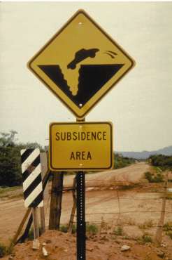
In many areas of the arid Southwest, earth fissures are associated with land subsidence. Earth fissures are caused by horizontal movement of sediment that occurs during compaction. These features start out as narrow cracks, an inch or less in width. They intercept surface drainage and can erode to widths of tens of feet at the surface and may extend more than 100 feet below the land surface. Fissures may be a few hundred feet to miles in length. One extraordinary fissure in the Picacho Basin, northwest of Tucson, Arizona, is 10 miles long.
 |
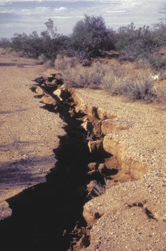 |
Sign warning motorists of subsidence hazard was erected after an earth fissure damaged a road in Pima County, Arizona (left photograph). Earth fissure near Picacho, Arizona (right photograph). (Photographs by S.R. Anderson, U.S. Geological Survey.)
Subsidence also occurs from local sinkhole collapse in areas underlain by
limestone, dolomite, and other soluble rocks. Areas susceptible to sinkhole
collapse are particularly common in the humid Eastern United States. Sinkhole
development occurs naturally but may be enhanced by human activities, such as
diversion and impoundment of surface water and pumping of ground water.
Ground-water pumping can induce sinkholes by reducing the buoyant support of
cavity walls and ceilings or by reducing the cohesion of loose, unconsolidated
materials overlying preexisting sinkholes. The effects of ground-water pumping
on sinkhole development can result from long-term declines in water levels or in
response to rapid fluctuations of water levels caused by pumping wells. Some
notable examples of rapid sinkhole development have occurred
in the Southeastern United States. Though the collapse features tend to be
highly localized, their effects can extend well beyond the collapse zone as a
result of the introduction of contaminants from the land surface to the
ground-water systems.
Finally, land subsidence can occur when organic soils are drained for agriculture or other purposes. Causes include compaction, desiccation, wind erosion, and oxidation of drained organic soil layers. These effects commonly are associated with the purposeful draining of the land surface but also may occur as a result of ground-water pumping near wetlands and other poorly drained areas. Subsidence at rates of an inch or more per year as a result of drainage has been observed over large areas such as the Sacramento-San Joaquin Delta in California and the Florida Everglades (Galloway and others, in press).
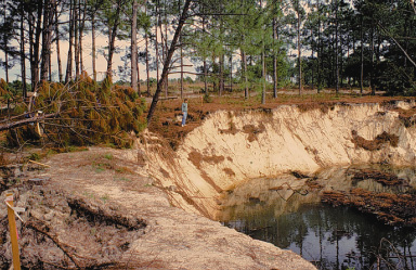
Development of a new irrigation well in west-central Florida triggered hundreds of sinkholes over a 20-acre area. The sinkholes ranged in size from less than 1 foot to more than 150 feet in diameter. (Photograph by Ann B. Tihansky, U.S. Geological Survey; see person in center for scale.)