The methods described in this report can be divided into two major groups; subjective rating methods, and statistical and process-based methods. The first group produces categories of vulnerability or intrinsic susceptibility (usually high, medium, and low) and the second group does not. Most importantly, the first group produces final products (such as low to high categories) that are most appropriately developed by, and for, water-resource decision makers whereas the second group produces final products (such as delineations of contributing areas or probabilities of exceeding targeted concentrations) that are most appropriately developed by scientists for decision makers. In this way, results of the first group are closely tied to policy or management objectives whereas results associated with the second group are closely tied to science objectives and typically require additional interpretation on the part of decision makers.
Subjective rating methods focus on policy or management objectives and range from basic index methods to subjective hybrid methods. Relative degrees of ground-water vulnerability (or susceptibility) usually delineated as low, medium, and high are common endpoints for all subjective rating methods. This broad definition includes 'index' methods and some forms of 'hybrid' methods, and is distinct from the statistical and process-based methods highlighted in this report that do not include subjective vulnerability ratings.
Index methods (and closely associated "overlay methods") assign numerical scores or ratings directly to various physical attributes to develop a range of vulnerability categories. The index method is one of the most commonly used categorical rating methods and was among the earliest methods used (National Research Council, 1993). Overlay methods (National Research Council, 1993) will not be distinguished from index methods for the purposes of this report as they both combine maps of physical attributes by assigning scores that generally include subjective rankings of vulnerability.
The most widely used index method is DRASTIC, named for the seven factors considered in the method: Depth to water, net Recharge, Aquifer media, Soil media, Topography, Impact of vadose zone media, and hydraulic Conductivity of the aquifer (Aller and others, 1985, p. iv). The point rating system for DRASTIC was determined by the best professional judgment of the original method developers. The DRASTIC method has been used to produce maps in many parts of the United States (Durnford and others, 1990), and in Israel (Melloul and Collin, 1998), Nicaragua (Johansson and others, 1999), Portugal (Lobo-Ferreira and Oliveira, 1997), South Africa (Lynch and others, 1997), and South Korea (Kim and Hamm, 1999). The index method has been used to develop maps at a variety of scales, including national, (Kellogg and others, 1997; Lynch and others, 1994), statewide (Hamerlinck and Ameson, 1998; Seelig, 1994), and individual counties and townships (Regional Groundwater Center, 1995; Shukla and others, 2000). The index method is a popular approach to ground-water vulnerability assessments because it is relatively inexpensive, straightforward, and uses data that are commonly available or estimated, and produces an end product that is easily interpreted and incorporated into the decision-making process (fig. 6).
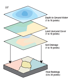 |
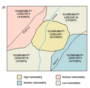
Figure 6. Generally, the index method incorporates subjective judgment to assign a numerical index or score to pre-determined variables such as depth to ground water, land use, and soils which are then combined to produce a total rating of the ground-water vulnerability or susceptibility (fig. 6a). Note that the maps overlaid in figure 6a do not include any data that quantify contaminant concentrations or chemical properties, although in some cases surrogate indicators of contaminant source strength (e.g. land use/cover) or other contaminant characteristics can be included. The scoring system is used to provide a simple map of vulnerability categories subjectively categorized from low to high (fig. 6b). These categories, while easily incorporated into management and policy decision making, can be difficult to defend scientifically because of inherent subjectivity. |
 |
In this report, hybrid methods in general are defined as any methods that combine components of statistical, process-based, and(or) index methods. Objective hybrid methods include combinations of statistical, process-based, or other objective components in the determination of explanatory variables or processes. On the other hand, subjective hybrid methods, which also include combinations of statistical, process-based, or other objective components, incorporate subjective categorization and indexing of vulnerability. Subjective hybrid methods commonly do not rely on preconceived scoring systems such as DRASTIC or other index methods but instead produce project-specific categorizations.
Vowinkel and others (1996) used pesticide-use intensity near public-supply wells, distance of the wells from aquifer outcrop (recharge) areas, soil organic matter content, well construction data, and land use to develop a map showing wells with low, medium, and high ground-water vulnerability to pesticides across the State of New Jersey. They showed that pesticides were detected most frequently in one part of the study area (categorized as "the high vulnerability group") and not at all in other parts of the study area (categorized as "the low group"). Nolan and others (1997) produced a map for the 'risk' of nitrate contamination in ground water using nitrogen loading, population density, soil hydrologic group, and woodland to cropland ratio. A scoring system was developed by examining scatterplots and boxplots of nitrate concentrations for each of the four factors and determining where nitrate concentrations increased above an assumed background concentration of 2 mg/L. The scoring system was then tested for statistical significance by comparing nitrate concentrations in each of the score categories using Wilcoxon statistical tests. The final map showed 'aquifer vulnerability' to nitrate based on 'increasing risk' categories of low to high. Rupert (2001) used nonparametric statistical correlations between nitrate concentrations in ground water and depth to ground water, land use, and soil drainage to develop a hybrid approach (fig. 7). In addition, Rupert (2001) compared the map with an independent set of nitrate concentration data to further elucidate the strengths of the map.
 |
| Figure 7. Some hybrid methods incorporate objective
measurements of, for example, concentrations of targeted contaminants in
the calibration of a model. However, in order to provide end products that
are easily incorporated into water-resource decision making, subjective
categorizations of vulnerability remain part of the method. Figure modified
from Rupert (1998). |
Other examples of subjective hybrid methods include those that combine the index method with a process-based model such as a contaminant-leaching model. The results of the contaminant-leaching model (or other process-based model) are used to calculate a score that is combined with scores from other mapped data to produce a ground-water vulnerability category. For example, Morgan's (1998) hybrid method used PATRIOT, or "Pesticide Assessment Tool for Rating Investigations of Transport" (U.S. Environmental Protection Agency, 1994). PATRIOT uses the process-based PRZM, or "Pesticide Root-Zone Model" (U.S. Environmental Protection Agency, 1993b) to calculate indexes for each polygon in the study area by quantifying the leaching potential of a targeted pesticide.
Other methods focus on science objectives and range from statistical to deterministic or process-based approaches or hybrid approaches that do not produce subjective categorizations. These methods commonly require additional interpretation by the water-resource decision maker (in consultation with the scientists) in order to meet policy and management objectives, but ultimately help decision makers to scientifically defend their decisions because the scientist does not subjectively determine indexes of vulnerability.
Statistical methods range from simple summary or descriptive statistics of concentrations of targeted contaminants to more complex regression analyses that incorporate the effects of several predictor variables. Maps showing concentrations of targeted contaminants measured in wells are often useful preliminary depictions of the spatial extent of contamination or occurrence although the maps are limited to descriptive rather than diagnostic purposes. Additional information and data such as potential sources of contamination and factors affecting the intrinsic susceptibility of the resource are often included in more rigorous statistical analyses such as logistic regression which attempts to account for potential explanatory variables.
Simple descriptive statistics such as means, medians, and percentiles are often used to summarize the point locational information on these maps, which eventually can be useful for more detailed analyses such as exploring relations with geology. For example, Ryker (2001) plotted arsenic concentrations analyzed in water samples collected from approximately 31,000 wells across the United States, developed a national-scale point map of arsenic concentrations, and used simple descriptive statistics to summarize the data. This limited approach addresses only occurrence and distribution and would require additional analyses to assess vulnerability or processes controlling vulnerability. Welch and others (2000) took the national-scale point map of arsenic concentrations one step further and overlaid maps of geochemical significance to illustrate potential natural controls on arsenic occurrence and distribution nationally. Maps of concentration data can be statistically associated with other maps of potential explanatory variables to provide a more comprehensive depiction of important factors influencing vulnerability. A simple statistical summary such as this is often a crucial part of a more detailed assessment (below) or may be sufficient to meet objectives of some types of assessment needs. Other geostatistical mapping techniques such as kriging are not typically used for ground-water-vulnerability assessments though may have potential for some objectives.
When a dataset of water-quality and potential explanatory variables is available, statistical models in the form of regression equations can be used to predict probabilities of contamination. Hypothesis tests allow elimination of insignificant variables that offer little to the assessment process. The procedure produces weighting factors that optimize the use of important variables thereby removing the need for subjective influences of best professional judgment in determining the importance of each variable. Logistic regression is a statistical method that predicts a probability of occurrence (Helsel and Hirsch, 1992). For example, equation 4, or one similar, is developed, where the left side of the equation is a probability scaled between 0 and 1. Re-expressing the equation by taking the logarithm of the odds ratio, log [ p/(1-p) ] of each side results in equation 5, the right side of which looks like a standard regression equation:
p = Probability (event) eq.
4
= e (b0 + b1 *var1
+ b2 *var2 + …) / (1 + e(b0
+ b1 *var1 + b2 *var2 + …)).
log (p/(1-p)) = b0 + b1*var1 +
b2*var2 + …, eq.
5
where
var1, var2, … are independent variables,
and
b0 , b1, … are statistically derived
coefficients.
Logistic regression analysis returns a hypothesis test for each independent variable that determines whether the variable explains a significant amount of the contamination probability. Variables that are statistically insignificant can be dropped. The remaining variables are weighted by their slope coefficients to produce the final estimates of probability.
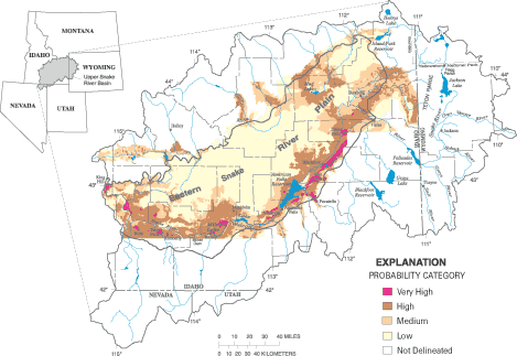
To illustrate the method, Erwin and Tesoriero (1997) modeled the probability of finding nitrate concentrations greater than 3 mg/L in ground water of the Puget Sound region using several independent variables. Probabilities were significantly related to well depth, the type of surficial geology, and percents of urban and agricultural land use within a 2-mile radius of the well. In addition, this approach can reveal other statistical relations. For example, it was shown that the probability of elevated nitrate concentrations decrease with increasing well depth, and is higher in agricultural and urban basins with concentrations highest in coarse-grained glacial deposits as compared to the two other types of surficial geology. As with any statistical model, these relations while statistically significant do not represent causality. By computing the values for each independent variable across the entire region and entering these into the equation, the predicted probabilities can be mapped for the entire region (figure 8). Rupert (1998) completed two assessments using logistic regression for atrazine/deethylatrazine and nitrate, and was able to conclude that the difference in the two assessments could largely be attributed to differences in the chemical behavior of the compounds. Squillace and Moran (2000) assessed the probability of detecting MTBE in drinking water supplied by ground water. Maps created by Tesoriero and Voss (1997), Rupert (1998), and Squillace and others (1999) delineated probability areas representing the probability of detecting the contaminant(s) as opposed to subjective categories of vulnerability that are used with the more common index methods. Nolan and others (2002) created a national-scale logistic regression model to simulate the probability of nitrate contamination in recently recharged ground water. This analysis was used to develop a map of the conterminous United States showing the probability that nitrate concentration exceeds 4 mg/L (considered above natural background concentrations).
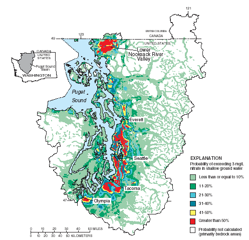 |
| Figure 8. Statistical methods such as logistic regression can use measured water-quality data and statistically significant independent variables (such as soil type, land use, and well depth) to objectively calculate the probability to exceed a targeted concentration (such as a Maximum Contaminant Level or other standard) in a study area. Figure modified from Erwin and Tesoriero (1997) |
Logistic regression equations can also be used to predict probabilities that more than one threshold is exceeded. Two regression equations, each with their own probabilities, can place a prediction into one of three categories, below the first threshold, between the first and second, and above the second threshold. For example, Mueller and others (1997) used basin characteristics and land-use information to predict the probabilities that nitrate concentrations in streams throughout the midwestern United States would exceed 3 and 10 mg/L. Predictive variables included the percent of corn grown in the basin as a surrogate for fertilizer applications throughout the area. Certainly, results of probabilistic methods, although quantifiable, must necessarily avoid erroneous interpretations near the 0 or 100 percent probability levels.
Predictions of the probability of contamination, or any other event, can be improved by using methods that produce estimates most closely matching measured data. Predictive statistical models, calibrated with measured data, can be compared to observed values for a separate set of observations not used in establishing the coefficients. This procedure will give a more complete picture of the reliability of predictions. A major strength of a statistical assessment method is its ability to use methods that mathematically assign empirical weights, thus allowing the possibility of eliminating statistically insignificant variables and highlighting those of most significance. In addition, modeling the probability that contamination occurs can result in an end product (map) showing statistically derived indications of vulnerability as opposed to the more subjective categorical rating methods. Statistical models produce coefficients that statistically best fit relations to observed data and thereby avoid the use of subjective ratings of vulnerability.
Process-based methods refer to approaches that either simulate or otherwise take into account physical processes of water movement and the associated fate and transport of contaminants in the environment. These approaches usually include the use of process-simulating models that calculate the distribution of vulnerable or intrinsically susceptible areas based on the movement of water and solutes. In this way, process-based methods can be purely based on deterministic models or can be a type of hybrid method that is based on physical and chemical laws, but incorporates statistical components such as regression equations to facilitate the simulation of complex hydrologic or chemical processes. The latter type of hybrid method is distinct from the subjective hybrid methods that include indexes, as shown in the previous section. As used in this report, process-based methods may be used to assess one or many underlying processes and can include direct field observations of environmental tracers placed in the context of a ground-water-flow system. Thus process-based methods include purely deterministic governing equations as well as other physically based techniques that are used to assess important underlying processes. In addition, process-based methods do not attempt to subjectively score processes or factors, and therefore, do not rate vulnerability categories. Instead, intrinsic susceptibility and vulnerability are typically represented by physically based ranges in model parameters or outputs.
Process simulating ground-water models are usually used in two different ways: 1) to determine the intrinsic susceptibility of an aquifer and, 2) to assess the vulnerability of ground-water supply to a targeted contaminant or contaminants. Process simulating models used to assess intrinsic susceptibility often focus on determination of the sources and(or) movement of water (including estimations of the age of water); whereas models used to assess vulnerability to a contaminant focus on the sources and(or) movement of the contaminant. In this way, process-simulating models typically account for one, or a few, important processes but do not typically account for all processes that control vulnerability. For example, Holtschlag and Luukkonen, (1997) used a process-based model to assess the potential for atrazine to leach to a water-table aquifer in Michigan, and thereby addressed an important component of aquifer vulnerability. Process-based assessments can be used to highlight the most important factors controlling vulnerability that ultimately help water-resource decision makers design targeted management practices.
The governing equation of ground-water flow incorporates Darcy's Law and the
Law of Conservation of Mass. In its basic form, the governing equation is a
three-dimensional time-dependent partial-differential equation that must be
solved numerically. With accurate boundary and initial conditions, inputs and
outputs, the equation can be used to model the interacting components of a complex
ground-water-flow system. Simplifying assumptions (for example, steady-state
or two-dimensional flow) are often used to decrease mathematical and assessment
complexity, and therefore, must be considered a potential source of uncertainty
and dealt with accordingly. MODFLOW (Harbaugh and
others, 2000), a popular computer modeling code that solves the governing
equations of ground-water flow, is often used for quantitative modeling of ground-water
flow and assessment of intrinsic susceptibility. MODFLOW includes several process-based
modules to simulate the interactions of key interacting components of the ground-water-flow
system. In addition, recent advances in parameter estimation techniques (Hill
and others, 2000) provide opportunities to objectively analyze various combinations
of calibrated parameters in ground-water-flow models and assess uncertainty.
Masterson and Walter (2000) delineated
the source of water to a ground-water resource under current conditions for
the different discharge areas of western Cape Cod, Massachusetts, with a three-dimensional
ground-water-flow model in conjunction with particle tracking (Pollock,
1994) to determine flow patterns and assess intrinsic susceptibility. This
approach, although complex, accounts for many interacting processes controlling
intrinsic susceptibility and is not limited to one or a few key processes. Their
map (fig. 9) shows where water recharging western Cape Cod
will eventually discharge, including contributing areas to pumping wells. The
map is useful in the determination of the intrinsic susceptibility of the aquifer
as well as public supply wells and surface-water bodies to contamination by
advective transport of contaminants.
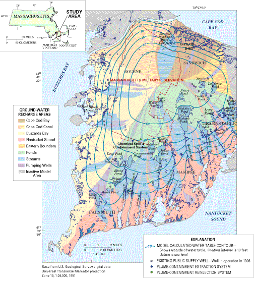 |
| Figure 9. An appropriately calibrated ground-water-flow model can accurately and realistically account for the interaction of discharging wells with each other and simulate contributing areas to these wells that are consistent with the system-wide flow field. This process-based method can address effects of partially penetrating wells and the concern that a contributing area for any one well depends on the interactions with other processes (e.g. pumping and recharge) that occur over the entire system. For example, if the pumping rate of one well changes, it may affect the contributing area of another well that is maintaining a constant pumping rate. The additional analysis of ground-water particle tracking is a powerful tool to objectively assess advective transport processes and intrinsic susceptibility while accounting for the effects of discharging wells and other factors. Figure modified from Masterson and Walter (2000). |
Other models and approaches to comprehensive assessment of interacting factors controlling intrinsic susceptibility are discussed throughout this report. Process-simulating models that combine assessments of the sources and movement of water as well as contaminants are not commonly used in ground-water-vulnerability assessments but could ostensibly account for all important hydrologic processes controlling vulnerability.
|
Balancing objectivity, complexity, and accuracy under
conditions of uncertainty. Generally, process-based approaches are designed to provide the most accurate representations of interacting physical and chemical processes that control intrinsic susceptibility and ground-water vulnerability. However, process-based approaches can be quite complex, are typically limited in spatial scale, and sources of uncertainty are difficult to quantify. Statistical approaches provide useful tools to assess the relative roles of important independent variables or factors controlling vulnerability over various spatial scales, but cannot include all the deterministic components needed to address complex interacting processes of cause and effect. In addition, statistical methods tend to be simpler to use than process-based approaches and often provide quantitative measures of statistical uncertainty. Index methods tend to be the most simple to apply and can be used over a range of spatial scales, but include subjective categorizations with uncertainty that cannot be quantified. Properly designed hybrid methods that combine statistical and deterministic or process-based components and exclude subjective categorizations can provide insights on important processes controlling vulnerability over a range of spatial scales while maintaining objectivity and hence scientific defensibility. On the other hand, a subjective hybrid method that combines results of an objective model with a subjective categorization scheme to produce indexes of vulnerability would lose objectivity and ultimately may not be scientifically defensible (fig. 7). It is clear that no one approach is better than the rest for all situations (fig. 12); however, a fundamental characteristic common to all scientifically defensible ground-water-vulnerability assessments is that scientific approaches must remain accessible to the water-resource decision makers while not compromising the scientific method through use of subjective categorizations. |
In addition to the use of environmental tracers to aid in the calibration of ground-water models, environmental tracers can be used directly to determine the source of ground water or the age of ground water (fig. 10). The stable isotopes of hydrogen and oxygen can be used to differentiate the source of water within a ground-water system (Coplen and others, 1999). Tracer techniques used to date ground water, such as carbon-14, chlorofluorocarbon (CFC), or tritium/helium dating (Plummer and others, 1993), can be used to assess a key component of the intrinsic susceptibility of a resource to modern sources of anthropogenic contamination. In an ideal example, a ground-water resource that was recharged hundreds of years ago is not currently susceptible to modern sources of anthropogenic contamination if there is no mixing with modern waters. For similar reasons, a ground-water resource that is recharged in modern times is susceptible to modern sources of anthropogenic contamination. In this way, quantification of the age of ground water and the degree of mixing of waters of various ages must be carefully quantified in order to represent surrogate indicators of the rates of flow and the residence time of the ground-water resource and ultimately the intrinsic susceptibility to modern sources of anthropogenic contamination. Bohlke and Denver (1995) combined ground-water dating with chemical and isotopic analyses to assess the history and fate of nitrate contamination in Coastal Plain watersheds. This approach addresses the vulnerability of a water resource to a targeted contaminant (nitrate) by moving one step beyond the preliminary assessment of intrinsic susceptibility obtained with only age dating and environmental tracers. Seiler and others (1999b) showed that the presence of caffeine and pharmaceuticals in well water might be indicative of wastewater contamination in an aquifer. Shelton and others (2001) showed how the occurrence of low-level volatile organic compounds (VOCs) in public supply wells could be used as indicators of ground-water vulnerability. That study used VOCs as a tracer of postindustrial-aged ground water recharged after the onset of intense urban development in California. Snyder and others (1998) used a ground-water-flow model with particle tracking to evaluate the intrinsic susceptibility of an aquifer in Clark County, Washington. In their analysis, ground-water age estimates obtained from chlorofluorocarbon (CFC) analyses were also used to help calibrate the effective porosity in the model. This approach enabled investigators to show where ground water with ages less than the time since the industrialization of the Clark County area are most likely to be affected by anthropogenic sources of contamination.
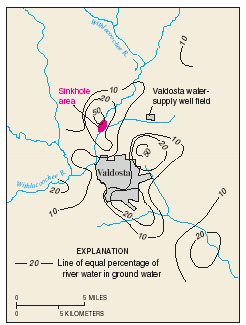 |
Figure 10. The Upper Floridan aquifer
near Valdosta, Georgia is hydraulically connected by sinkholes and other
conduits to flow in river channels. Contaminants in the surface water
can move rapidly through the ground-water system and contaminate water
supply wells. This is common in karst terrain and poses significant challenges
for process-based assessments of intrinsic susceptibility. Plummer and
others (1998) identified three basic
sources of water in the area; river water, young regional infiltration
water, and old regional water emphasizing the complexity of the flow system
and difficulties in assessing intrinsic susceptibility of the ground-water
resource. Using the oxygen-18 stable isotope and chloride concentrations,
the percentage of river water in the ground water was determined thereby
providing an objective quantitative assessment of an important component
of intrinsic susceptibility for the hydrologic conditions analyzed. Figure
modified from Plummer and others (1998). |
For many objectives requiring ground-water-vulnerability assessments, advective transport may be the most important transport mechanism; however, it is important to assess the relative roles of various transport mechanisms in the overall movement of a given contaminant because advection alone may not accurately portray important aspects of the transport pathways. For example, Reilly (1993) considered the relative effects of density-dependent solute-transport (including advection and dispersion) to analyze the upconing of salty water in a coastal well (fig. 11)
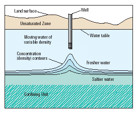 |
Figure 11. Whereas advective transport is a dominant control on the intrusion of saltwater into fresh water resources, it has been shown by many investigators that the differences in density between saltwater and freshwater and the effects of diffusion and dispersion can play an important role. In many cases, it may be reasonable to assume that non-advective processes are insignificant. However, the relative importance of non-advective transport processes and other physical, chemical, and biological factors that potentially control the concentrations of a given contaminant must be determined before deciding on the most appropriate approach to take for a ground-water-vulnerability assessment. Figure modified from Reilly (1993). |
Next: Scientifically defensible
gournd-water-vulnerability assessments
Back: Understanding the hydrologic system and the
associated behavoir of contaminants: A necessary step in scientific assessments
of ground-water vulnerablity
Report