
Coastal Conflicts
Conflicts between human activities and natural systems exist wherever the two come together in the coastal environment; indeed, some clashes are inevitable. However, increasing demands on our coastal environments as a result of the competition between human goals and natural processes have led to dramatic examples of these conflicts. Among the most striking examples are Ocean City, Maryland; Hurricane Hugo's effects on Puerto Rico and South Carolina; Isles Dernieres, Louisiana; and Boston Harbor, Massachusetts.
Ocean City--An Urbanized Barrier Island
Ocean City, Maryland, has been a popular beach resort for more than a century. During the 1920's, several large hotels and a boardwalk were built to accommodate visitors. Development was slow but steady until the early 1950's, when a dramatic boom in construction began that lasted almost 30 years. Early concerns about the coastal environment were raised in the late 1970's and led to Federal and State laws to limit dredging and filling of wetlands.
The resort is built on the southern end of Fenwick Island, one of the chain of barrier islands stretching from New York to Florida. Ocean City Inlet, which connects the quiet backwater bay with the Atlantic Ocean at the southern end of the island, was opened during the great hurricane of 1933, by storm-surge overwash from the bay side. To maintain the inlet as a navigation channel, two stone jetties were constructed by the U.S. Army Corps of Engineers shortly after the storm. The jetties have stabilized the inlet, but they have drastically altered the sand-transport processes near the inlet. The net longshore drift at Ocean City is southerly; it has produced a wide beach at Ocean City north of the jetty, but Assateague Island, south of the inlet, has been starved of sediment. The result is a westerly offset of more than 500 meters in the once-straight barrier island.
The most damaging storm to hit Ocean City within historic times was the Five-High or Ash Wednesday northeaster of early March 1962. It caused severe erosion and flooding along much of the middle Atlantic Coast. For 2 days, over five high-tide cycles, all of Fenwick Island except the highest dune areas was repeatedly washed over by storm waves superimposed on the 2-meter-high storm surge. Property damage to Ocean City alone was estimated at $7.5 million. Given the dense development of the island over the last 20 years, damage from a similar storm would today be hundreds of millions of dollars.
Hurricane Hugo--Storm Devastation
Hurricane Hugo struck Puerto Rico in mid-September 1989, packing wind speeds of more than 250 kilometers per hour at the height of the storm. The 0.6-meter storm surge, combined with the rising tide and the 3- to 5-meter storm waves, inflicted serious damage to the island and its economy; total monetary damage was $2.5 billion, and eight people died during the hurricane and its aftermath. The position of the shoreline remained generally constant, but much sand was removed from the beach and deposited behind the dunes, outside of the coastal environment. Coral colonies were choked by sediment, and many were destroyed. A large offshore sand deposit (about 90,000,000 cubic meters) was leveled by storm waves and dispersed over the ocean floor.
Hugo hit the U.S. mainland just north of Charleston, South Carolina, bringing sustained winds of 215 kilometers per hour and a maximum storm surge of more than 6 meters. The barrier islands along the South Carolina coast are generally less than 3 meters above sea level, and many showed evidence of having been completely inundated by the storm surge. In many places, beaches were severely eroded and dunes were leveled. Much of the sand removed from the beach was overwashed landward or carried offshore. A total of 29 people in South Carolina died, and total damages were $5.9 billion.
The damage Hugo caused along South Carolina's barrier islands and shore communities clearly shows the importance of good construction and the natural protection provided by a wide, high beach and sand dunes. Folly Beach, south of Charleston, was on the weaker (south) side of the hurricane, but its beaches were already severely narrowed by long-term erosion; homeowners had dumped boulders and concrete rubble on the beach to form a protecting revetment. The revetment proved useless during Hugo. The storm surge (over 3.5 meters at Folly Beach) overtopped the structure, caused major damage to beachfront houses, and totally swept away a popular seafood restaurant. Isle of Palms and Sullivans Island, north of Charleston, suffered substantial damage, but the effects were somewhat lessened by a wide beach and dunes. Houses that survived were built to withstand high winds and flooding, in contrast to homes built to lower standards that were totally destroyed.
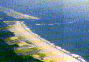
Isles Dernieres--Eroding Barrier Islands
The Isles Dernieres barrier chain stretches for 32 kilometers along the coast of Louisiana, about 100 kilometers west of the mouth of the Mississippi River and 120 kilometers southwest of New Orleans. Coastal studies conducted since 1985 by the USGS and the Louisiana Geological Survey indicate that the Isles Dernieres are eroding as fast as 20 meters per year. These high erosion rates, caused by both natural forces and human actions, have produced one of the most rapidly deteriorating shorelines in the world.
Geologic investigations during the last 40 years have shown that the low-lying plain and coastal barrier islands of southern Louisiana consist of fine sand and mud deposited by the Mississippi River in four successive delta complexes over the past 7,000 years. Each time the river channel moved to a new position, the combination of natural subsidence and reduction in sediment supply caused erosion and deterioration of the abandoned delta. The Isles Dernieres mark the end of a delta that reached its maximum size about 500 years ago.
By the mid-1800's, the Isles Dernieres were a single wide barrier island supporting mature forests and a thriving resort community. A devastating hurricane struck the island in 1856, destroying the resort and killing hundreds of people. Over the past 130 years, natural processes of storm erosion and a rise of more than a meter in relative sea level have dramatically reshaped the Isles Dernieres. The once-continuous island has been cut by wide tidal inlets into five smaller islands, which have shrunk rapidly in recent years. They are now so close to sea level that they are overwashed during storms and high tides six to eight times a year. Extrapolation of the historic data shows that if these erosion rates continue the Isles Dernieres will be submerged by approximately the year 2020. Although the disappearance of these islands will not have an immediately noticeable impact, as would the destruction of a developed barrier like Ocean City, Maryland, it will expose the wetlands and estuaries of southern Louisiana to greater wave and current action and may hasten the loss of these vital resources.
Boston Harbor--Centuries of Pollution
Boston, one of the oldest and largest metropolitan centers in the United States, covers about 1,500 square kilometers and includes more than 75 separate cities and towns. One of the earliest metropolitan boards to unite these separate entities was the Metropolitan Sewerage Board, established in 1889 to deal with the growing pollution of Boston's rivers by raw sewage. A century later, Boston Harbor and the surrounding beaches are still plagued by pollution. In addition to the continued sewage problem, heavy metals (chromium, copper, lead, and zinc, for example) also contaminate the sediments in the harbor, as well as the fish and shellfish that are a major source of revenue. These contaminated sediments may continue to be sources of toxins long after the primary pollution sources are reduced or eliminated.
A $6 billion cleanup plan, to be completed by the year 2000, includes elimination of ocean discharge of sewage sludge, upgrades of sewage treatment, and construction of a new ocean outfall for the treated effluent about 13 kilometers seaward of the harbor mouth. As part of the effort and in cooperation with the Massachusetts Water Resources Authority, the USGS has established a long-term current and sediment-transport monitoring station in Massachusetts Bay to provide information vital to the design of the proposed ocean outfall. Additional USGS studies, coordinated with other Federal and State agencies through the Massachusetts Bay Management Committee, are mapping the sediment composition on the bay floor, determining the levels of various contaminants in the sediments, and estimating rates of sediment accumulation and mixing. Data and interpretations gained though these studies are helping to determine the fate and effects of pollutants and will assist coastal managers to develop efficient cleanup procedures and mitigation measures.
| Maintained by J.M. Watson | https://pubs.usgs.gov/circ/c1075/conflicts.html | Last updated 9.15.97 |