Coastal Change
Diverse and complex natural processes continually change coasts physically, chemically, and biologically, at scales that range from microscopic (grains of sand) to global (changes in sea level). Regional and local characteristics of coasts control the differing interactions and relative importance of these natural processes. Human activity adds yet another dimension to coastal change by modifying and disturbing, both directly and indirectly, the coastal environments and the natural processes of change. Earth-science research on coastal dynamics can quantify these changes and improve our ability to predict coastal responses to human actions.
Coastal Focus: Montauk Lighthouse, New York
Natural Processess
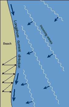 Coastal lands and sediments are constantly in motion. Breaking waves move sand along the coast, eroding sand in one area and depositing it on an adjacent beach. Tidal cycles bring sand onto the beach and carry it back into the surf. Rivers carry sediment to the coast and build deltas into the open water. Storms cause deep erosion in one area and leave thick overwash deposits in another. Plants retain sediment in wetlands and impede movement of coastal dunes. Natural processes that change the water level also affect coastal dynamics. Taken individually, each natural process of coastal transport is complex; taken collectively, they create an extraordinarily intricate system that attempts to achieve a dynamic balance.
Waves, Tides, and Weather
Winds create waves that ripple across the surface of lakes and seas until they break on the shallowing bottom and crash into the shore. In many areas, prevailing winds produce waves that consistently approach the coast at oblique angles. Even the slightest angle between the land and the waves will create currents that transport sediment along the shore. These longshore currents are a primary agent of coastal movement; they are a major cause of sand migration along barrier and mainland beaches.Tides ebb and flood in response to the gravitational attraction of the moon and sun; exceptional high and low tides occur each month when the sun and moon are aligned. Tides help determine where the waves break -- low on the beach at low tide, high on the beach at high tide -- and, therefore, where sand is deposited and removed. Rip tides, or undertow, occur along most beaches and can move significant amounts of sand offshore.
Storm systems along coasts contain high winds, create large waves, and cause storm surges that raise water levels as much as 7 meters above normal. Although storms are sporadic, they are the primary cause of beach erosion along many coasts. Storms carry sand seaward, forming offshore bars; much of this sand migrates landward during calm weather. Some areas are more storm prone than others. Storms often are concentrated in specific seasons; along the eastern seaboard, for example, hurricanes occur in the late summer and early fall, and storms are especially frequent during the winter months. These seasonal trends result in a general difference between the winter "eroding" beach and the summer "building" beach that is most common along parts of the west coast.
Coastal Focus: Galveston, Texas
Other local changes in water level occur when the land either rises or falls relative to the water. Along tectonically active coasts, such as the coast of earthquake-prone southern California, land may rise as much as 4 centimeters per century. In recently abandoned deltas, such as near the mouth of the Mississippi River, compaction of newly deposited sediment results in extensive land subsidence (as much as 1 meter per century). The Earth's crust in parts of Alaska and the Great Lakes area, which was pressed down by the weight of the massive ice sheets that blanketed the north during the last great ice age, is now rising due to the retreat of the glaciers. In southeastern Hudson's Bay, Canada, this crustal rebound is raising vast areas of land at rates as high as 4 meters per century; rates along Lake Superior's north shore reach 60 centimeters per century.
Global changes in sea level result from tectonic processes, such as the down- or up-warping of the ocean basins, or from changes in the total volume of water in the oceans. During the last great ice age, which began 36,000 years ago, huge amounts of ocean water were transformed into glaciers, resulting in a 100-meter drop in the global sea level. We are still emerging from that ice age, and sea level has been rising continuously over the last 20,000 years; during the past century, the rate of sea level rise has averaged 10-15 centimeters per century worldwide.
Gradual changes in weather patterns, salinity, tidal action, and sea level allow normal plant succession to occur in protected coastal environments. Abrupt changes in these conditions often result in widespread destruction of plant communities and the loss of sediment being held by their roots. For example, erosion of barrier islands can lead to saltwater intrusion and increased wave action, which kills plants and destroys the wetlands behind the islands.
The major sediment sources for the beaches of southern California are eroding headlands and adjacent beaches and, to some degree, sediment from local rivers in flood. The major agent of sediment transport along the coast is longshore drift, which moves the sand southward. Submarine canyons in some areas are so close to the shore that they intercept the longshore drift and funnel beach sand seaward into very deep water. The beaches are relatively steep, resulting in a narrow wave zone between high and low tide. This narrow zone receives the brunt of the waves' pounding, and movement of beach sediment (erosion and deposition) is concentrated within this zone.
The major source of new sediment to the barrier beaches of the Southeastern United States is erosion of the adjacent headlands and beaches, whose sand generally migrates south as a result of longshore transport. Sand transported landward from the continental shelf also may contribute to the coast and nearshore sand budget. The gentle slope of the southeastern beaches results in widely separated high- and low-tide zones, and wave energy is absorbed along this broad surface.
Plant life is vital to building and maintaining wetlands. The coastal Louisiana wetlands are biologically zoned on the basis of the salinity of the water and the fluctuations in water depth, with different plant populations living in different areas. The dependence of these wetlands on the Mississippi River and its distributaries as a direct source of sediment and fresh water leaves them vulnerable to changes in the river system. Their dependence on barrier islands for protection against waves leaves them vulnerable when the barrier islands are eroded.
Coastal Focus: Chicago, Illinois
Wave and tide action are generally limited in lakes because they are relatively small bodies of water. However, due to Lake Erie's size and oblong shape, communities at the ends of the lake, like Buffalo and Toledo, suffer from dangerous storm surges. These storm surges can quickly raise the local lake level by more than a meter. Though they may last only a few hours, surges can do considerable damage, primarily from flooding.
People's activities are often conducted without an adequate understanding of coastal geology and processes. As a result, they can lead to unforeseen degradation of coasts. Even human actions intended to save or improve the coast may inadvertently increase erosion. Cooperative scientific investigations are starting to provide the crucial information needed to minimize the unintended effects of human disturbances along coasts.
Coastal Focus: Presque Isle, Pennsylvania
An important source of sediment to Louisiana's deltaic wetlands was periodic flooding of the Mississippi River, which deposited new material on the flood plain. Massive levees built along the riverbanks now contain these floods and eliminate the supply of sediment to the wetlands. As a result, the natural compaction and subsidence of the delta are no longer balanced by the deposition of new sediment, and the relative local sea level is rising as much as 1 centimeter per year. Sediment-laden water, retained by levees along the Mississippi River, deposits its load into deep water at the mouth of the delta, where most of the sediment is lost to the coastal environment. To counteract the effects of damming and channelization, the U.S. Army Corps of Engineers is building structures to divert fresh water from the Mississippi River to adjacent wetlands.
Attempts to counter sediment starvation along severely eroding coasts have included the artificial replenishment of beach material by placing sand directly onto the beach. Beach nourishment is not a permanent solution and is expensive, but in some regions it can be cost effective. The lack of clean sand suitable for fill often limits beach nourishment programs, but offshore surveys can locate sand bodies for dredging and transport to the beach. A few beach replenishment programs have had long-term positive effects; the Miami Beach replenishment done in the late 1970's at a cost of $64 million has already survived more than a decade. Typically, these nourishment projects are not as effective; along the east coast, half of the replenished beaches lasted 2 years or less.
Coastal Focus: Prince William Sound, Alaska
Water-Level Changes
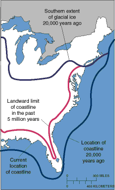 In addition to the daily cycles of tides, many other forces lead to significant changes in water level. Predominantly closed bodies of water such as lakes experience dramatic water-level changes in response to precipitation, spring snowmelt, and evaporation. A prolonged period of wet weather in Utah in the early 1980's, for example, raised the Great Salt Lake's water level to record highs, flooding parts of Salt Lake City.
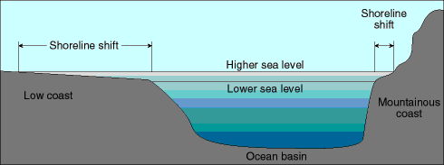 The slope of a coast is critical to determining how water-level changes will affect it. Steeply sloping coasts experience small shifts in their coastlines as the water level changes; however, because wave action along steep coasts is concentrated within a narrow zone, small water-level increases can result in significant erosion of bluffs or dunes. On a gently sloping coast, like the U.S. east coast or around the Gulf of Mexico, small changes in water level cause the coastline to shift dramatically; however, the gentle slope absorbs and dissipates the waves' energy along a broad front.
Coastal Vegetation
Rooted plants flourish along the shores of bays, estuaries, deltas, and other coastal environments that are protected from the full fury of pounding waves. Plants stabilize dunes through root networks. They build and maintain marshes by catching and retaining in their roots the fine sediment carried by the water. Their natural decay cycle further enriches coastal soils and sediment with decomposing plant matter. Differences in weather regimes, tidal depth, and water salinity determine which plant populations will thrive in a given coastal environment.
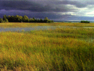 A large variety of plant species occurs in coastal areas where tides are extreme, since some plants require total submergence, some tolerate cyclical submergence and aeration, and others flourish in environments that remain dry except at the highest tides. Diversity of species is greatest where water salinity is low. Those few plant species that live in the most saline water have developed ways to control the internal osmotic pressure of their cells.
Local Conditions
While the same dynamic processes cause continuous change on every coast, coasts do not all respond in the same way. Interactions among the different processes and the degree to which a particular process controls change depend upon local factors. They include the coast's proximity to sediment-laden rivers and tectonic activity, the topography and composition of the land, the prevailing wind and weather patterns, and the configuration of the coastline and nearshore geometry. Earth-science research is showing that these local conditions determine not only the changes to the coast but also the type of coast produced.
Mainland Beaches (Southern California)
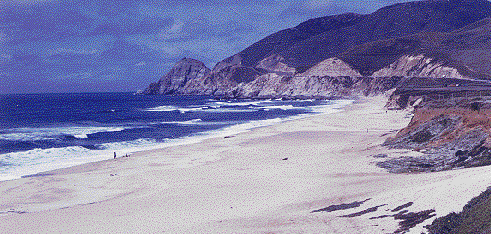 The mainland beaches of southern California border an active tectonic region of fault-bounded crustal blocks with high elevations. Ancient shoreline terraces hundreds of meters above present sea level are evidence of rapid and extensive crustal uplift along the coast. The narrow offshore continental shelf is cut by numerous submarine canyons and bordered by deep ocean basins. The weather is temperate year round, but winter storms often dramatically reshape the coast.
Barrier Beaches (Southeastern United States)
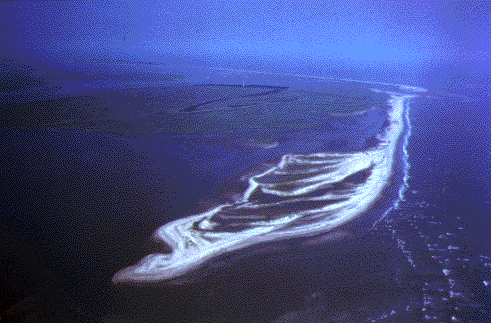 The southeastern coast, rimmed by a series of barrier islands and spits, separates the mainland coastal plain from a wide, gently sloping offshore continental shelf. This generally tectonically stable region has a storm and hurricane season during the late summer to winter months; high-wind events such as Hurricane Hugo, which came ashore near Charleston, South Carolina, in 1989, are not uncommon. Most rivers cutting through the low-lying coastal plain flow slowly to the sea and deposit their sand-sized sediment in bays and estuaries before reaching the coast. The river's suspended load of finer particles settles out in the sounds and bays that are protected by barrier islands and spits.
Wetlands (Coastal Louisiana)
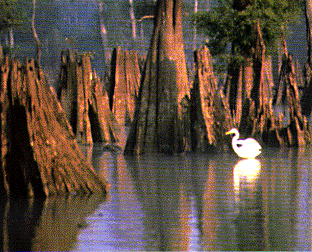 The gulf coast of Louisiana includes a broad expanse of wetlands sheltered from the wave action of hurricanes and winter storms by low-lying barrier islands. Both the wetlands and their protecting islands have formed as a direct result of the shifting of the Mississippi River delta lobes during the past 7,000 years. The deltaic processes that control the movement of water and sediment have resulted in a system of complex drainage patterns, natural ridges and levees, and offshore barrier beaches -- all of which restrict the advance and encroachment of salt water.
Lake Shores (Lake Erie)
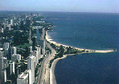 Lake Erie is the shallowest of five large interconnected bodies of fresh water, known collectively as the Great Lakes, that form part of our political border with Canada. The basins of the Great Lakes were carved by continental glaciers during the last great ice age and filled with melt waters as the glaciers retreated northward.
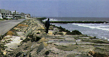 Much of Lake Erie and its beaches and cliffs are frozen during winter, inhibiting the formation of storm waves and reducing erosion. However, during ice formation in early winter and during the spring thaw, ice processes can accelerate erosion. The spring rains, snowmelt, and low evaporation rates cause Lake Erie's average water level in June to be more than 30 centimeters above the typical January level. Several years of above-normal precipitation, as in the mid-1980's, can cause Lake Erie's water level to rise significantly above its long-term average, increasing the likelihood of flooding and erosion.
Human Intervention
Human activities add another layer of complexity to the natural processes of coastal lands and materials. These activities may have direct or indirect effects on our changing coasts. They may affect sources of new sediment to the coast and the movement of sediment within the coastal environment; they may promote changes in sea level, both local and global.
Sediment Starvation
For some coastal regions, such as the Pacific coast, a large part of their sediment budget is supplied by rivers. Dams built for flood control and water catchment along the rivers leading to these coasts inhibit the transport of large-grained sediments. Lacking new material, the sediment-starved coasts erode and migrate inland. Damming of tributary rivers to the Mississippi River over the past 60 years has also reduced the movement of sediment. Studies by the USGS in recent years demonstrate that the amount of sediment carried by the Mississippi has been cut in half, aggravating the deterioration of Louisiana's wetlands.
Pollution
As the number of active landfills dwindles and coastal populations grow, offshore waste dumping and coastal pollution increase. This additional dumping increases the possibility of improper waste disposal polluting the coastal environment. Living coral reefs are particularly vulnerable to pollution, but other coastal environments suffer as well. Medical waste, including used hypodermic needles, was washed onto the New Jersey and New York beaches during the summer of 1988, resulting in an economic disaster for the recreation industries in the region. Fishing industries have also been severely damaged by coastal pollution; more than one-third of our Nation's shellfish beds are closed or restricted as a result of contamination.
Sediment Trapping
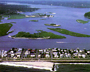 The natural movement of sand is at best a nuisance for owners of beachfront property. When this movement results in a net loss of sand from the beach, the natural process may be considered by owners as a serious threat. To prevent beach loss, groins are often constructed out into the water. These solid structures impede the littoral drift of sand caused by longshore currents. The beach then expands on the updrift side of the groin; however, the downdrift side of the groin loses sand because of continuing longshore movement. Small groins may have little effect on sediment movement along the entire beach. Larger groins or jetties, such as the ones at the southern end of Ocean City, Maryland, and at Cape May, New Jersey, can lead to impressive retention of beach materials on the updrift side, but these gains must be balanced against the coastal degradation on the downdrift side. Sediment carried out past the jetty may be deposited as shoals offshore in deeper water and removed from the active coastal sediment budget, further increasing downdrift erosion.
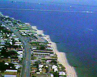 Seawalls constructed to protect property along retreating beaches often exacerbate beach erosion. They confine the wave energy and intensify the erosion by concentrating the sediment transport processes in an increasingly narrow zone. Eventually, the beach disappears, leaving the seawall directly exposed to the full force of the waves. For example, a massive seawall built to protect a highway and beach houses along the northern New Jersey coast has resulted in the complete disappearance of the beach itself.
Coastal Degradation
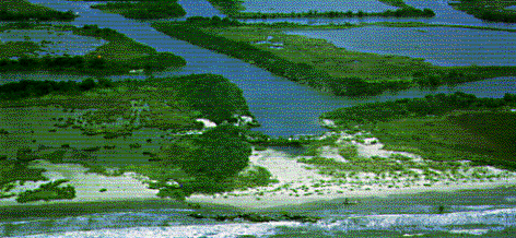 Human actions that lead to the destruction of dune grasses and the disturbance of coastal landforms promote increased erosion and movement of beach materials. Off-road vehicles and foot traffic on sand dunes compact sand, destroying plant roots and animal burrows. Other wildlife habitats, such as nesting and feeding areas for shorebirds, are disturbed by human activity; young birds are especially vulnerable to these disruptions.
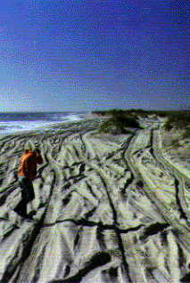 Sand dunes help absorb the pounding of high waves and reduce overwash flooding during storms; bulldozing dunes to improve views of the sea destroys this natural protection. Dredging navigation channels and tidal inlets and discharging the material in deep water also remove sediment from the coastal system and interfere with longshore transport. Canals cut in wetlands for navigation, pipelines, and drainage provide channels for salt-water invasion during storms and high tides; the increased salinity often kills marsh plants, leading to accelerated land loss and deterioration of wetlands.
Water-Level Changes
Human activities can cause local and possibly global changes in sea level. Pumping of ground water, salt brines, and petroleum resources from coastal environments has led to significant subsidence in many regions; the Texas coast around Galveston Bay has experienced a particularly alarming rise in its relative sea level. The increasing release of greenhouse gases, such as carbon dioxide and methane from automobile and industrial exhaust, may promote global warming, the melting of massive ice sheets in Greenland and Antarctica, and consequently the raising of sea level worldwide.
