Prince William Sound, Alaska
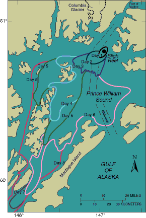
On March 24, 1989, an oil tanker struck Bligh Reef in Prince William Sound, Alaska, releasing more than 200 million liters of oil. The map above outlines the oil-spill front as it expanded from 1 to 8 days after the spill; it was compiled from aerial observations by the National Oceanic and Atmospheric Administration, Exxon, the U.S. Coast Guard, and the Alaska Department of Environmental Conservation. Bottom sediments studied by the USGS more than 7 weeks after the spill contained no clear evidence of oil pollution; possible traces of contamination were found near the south end of the Sound, but the presence of oil could not be confirmed. Much of the oil was carried onshore by surface currents and deposited along the beaches. Long-term monitoring is needed to assess the effect of the spill on the marine environment.(Modified from Carlson, P.R., and Reimnitz, Erk, 1990, Characterization of sample sites along the oil spill trajectory in Prince William Sound and the Gulf of Alaska: U.S. Geological Survey Open-File Report 90-39-A, 24 p.)
| Maintained by J.M. Watson | https://pubs.usgs.gov/circ/c1075/prince.html | Last updated 9.11.97 |