
National Water-Quality Assessment
(NAWQA) Program
Design of the National Water-Quality
Assessment Program:
Occurrence and Distribution of Water-Quality Conditions
United States Geological Survey Circular 1112
By Robert J. Gilliom, William M. Alley, and Martin E. Gurtz
Flowpath Studies
The primary objectives of Flowpath Studies are to characterize the
spatial and temporal distribution of water quality in relation to
ground-water flow in shallow ground-water systems for particular
settings, increase understanding of the natural processes and human
influences in these settings that affect the evolution of
ground-water quality along flowpaths through the saturated zone, and
evaluate the degree and water-quality significance of interaction
between ground water and streams for selected settings. Ideally,
many of the Flowpath Studies provide a perspective on the potential
significance of poor-quality shallow ground water to regional
aquifers and streams.
Most Flowpath Studies are within Land-Use Study areas where the areal
distribution of shallow ground-water quality is broadly characterized.
Because of the low spatial density of sampling in many Land-Use
Studies, Flowpath Studies frequently include additional areal sampling
of shallow ground water in the vicinity of the transect.
Selection of Flowpath Study Sites
Typically, one to two Flowpath Studies are undertaken in each Study Unit during the first NAWQA cycle. Principal considerations for selecting and prioritizing Flowpath Study sites are as follows:
- A large part of the upgradient area of the well transect is
located in a land-use setting examined during a Land-Use Study.
- When possible, the transect is located in an indicator basin
selected for surface-water studies and passes through an area of the
land use for which the indicator basin was chosen.
- The geologic framework and hydrology of the area are well
defined and typical for the land-use setting. Ideally, the flow
system should be simple and well understood.
- Ideally, the flow in the stream at the downgradient terminus of
the transect is small enough so that comparisons between ground- and
surface-water quality are feasible.
- When possible, Flowpath Studies are done at or near field
research sites supported by other agencies to benefit from already
existing data-collection activities.
Transect Design and Sampling Strategy
Ideally, well transects extend along a ground-water flowpath. Most
flowpath transects either begin or terminate at a stream. As an
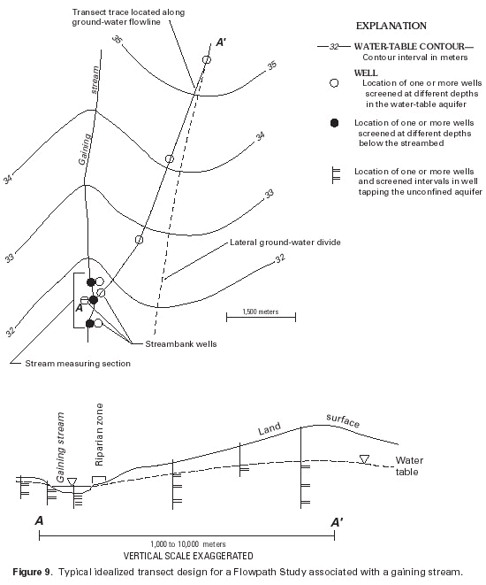
example, a typical transect in terrain with a gaining stream is shown
in figure 9. This "typical" transect
illustrates some of the general concepts and level of detail
envisioned for a Flowpath Study. Variations of the design are made to
adjust to differences in scales and complexities of ground-water flow
in different terrains. Four to six clusters of two to three wells are
located along the transect in figure 9,
for a total of 10 to 12 wells. Generally, in each cluster, one well
is screened beginning 1 to 2 m below the lowest anticipated position
of the water table, and the additional wells are screened between 5 to
75 m below the water table. Typically, well screens do not exceed 2 m
in length to ensure that water samples are representative of a "point"
in the ground-water flow system. To best define the hydrologic
system, one well cluster is located at the ground-water divide and
another at the bank or in the bed of the gaining surface-water body.
Additional streambank wells include wells on the streambank opposite
the well transect and wells screened directly below the streambed.
The samples from these wells provide the best measure of the quality
of ground water that interact with the stream. Where streambed wells
cannot be maintained, an option is to collect a one-time series of
ground-water samples below the streambed by driving a well point, or
minipiezometer (Lee and Cherry, 1978), into the streambed and collect
water samples and water-level information at several depths.
(Click on image for a larger version, 21K) |
| Figure 9. Typical idealized transect design for a Flowpath Study associated with a gaining stream. |
In general, well transects are located in unconsolidated earth
materials, and the wells are constructed as part of the study.
Occasionally, a well transect is located so that one or two existing
wells can be used. The depth of the deepest screened interval in a
transect well and the length of a transect vary considerably among
different hydrogeologic settings. Ideally, the deepest transect wells
are screened to the depth at which water samples show little or no
human influence on water quality. Usually, the lengths of well
transects, which range from one to several kilometers, depend on the
scale of the flow system.
Each Study-Unit team designs a specific sampling and analytical
strategy for each transect site to meet study objectives. Typically,
hydraulic measurements associated with a well-transect site include 2
years of monthly head measurements in all wells, three to four
measurements of stream base flow at different seasons of the year (for
transects with streams) and, if feasible, seepage investigations near
the terminus of the transect during the annual low-flow period.
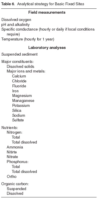
Water-quality sampling associated with each Flowpath Study typically
consists of at least one sample from all wells analyzed for the
national target analytes (table 5 and table 6) and isotopes (such as tritium) or
chlorofluorocarbons that allow an estimate of water age; monthly or
seasonal samples from some wells for selected analytes, particularly
for wells screened near the water table; and samples of base flow in
the stream associated with the well transect that are analyzed for
selected analytes.
Flowpath Studies during the initial phase of NAWQA are viewed as the
potential beginning of long-term studies that will lead to more
intensive studies. Moreover, networks established as part of some
Flowpath Studies may form an important element of a long-term trend
network.
Continue to References, Glossary, or return to Contents
