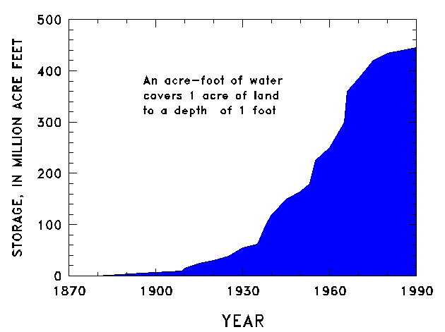
Figure 1. Cumulative reservoir storage in the United States ( from U.S. Geological Survey, 1990 ).
As the population grew during the 1880's, people moved west and away from perennial water supplies. The westward expansion also moved population into more arid regions of the country where the flow of rivers and streams was much less dependable than in the humid East. Dependence on water storage and transmission increased as the distances from reliable water sources increased.
During the first two-thirds of the 20th century, water planners and managers sought to develop the Nation's water resources to meet the growing needs of the country. Large reservoirs and aqueducts were constructed to provide water for public supply, industry, irrigation, and hydropower; to provide flood control; and to foster regional economic development. By the 1960's and the 1970's, concerns about the environmental effects of large reservoirs, as well as increasing construction costs and the scarcity of suitable storage sites, curtailed the construction of significant additional reservoir capacity (fig. 1).

Figure 1.
Cumulative reservoir storage in the United States
(
from U.S. Geological Survey, 1990
).
The development of data on the flow of the Nation's rivers mirrored the development of the country. Increasing need for reliable water supplies quickly led to the need for streamflow data with which to design storage and distribution facilities. In 1889, the first stream-gaging station operated in the United States by the U.S. Geological Survey (USGS) was established on the Rio Grande near Embudo, New Mexico. The establishment of this early station was an outgrowth of efforts to train individuals to measure the flow of rivers and streams and to define standard stream-gaging procedures. As the need for streamflow data increased, the stream-gaging program of the USGS has grown to include (as of 1994) 7,292 continuous-record stream-gaging stations (herein referred to as "stations") in the United States, Puerto Rico, and the Trust Territories of the Pacific Islands (fig. 2). More than 90 percent of these stations are operated with at least partial support from other Federal, State, and local agencies. This report briefly describes the evolution and current status of the stream-gaging program of the USGS, the uses of streamflow data, the data-collection process, evaluations of the stream-gaging program, and challenges for the future.