![]()
Water quality in the 92-mile reach of the Snake River between Milner Dam and King Hill at the upper Snake River Basin outlet (see location map on page 4) is degraded because of the cumulative effects of decades of agricultural and industrial activities. Sources of pollutants to the Snake River downstream from Milner Dam include irrigation returns, agriculturally degraded tributary streams, fish farms, and wastewater-treatment facilities [4]. Since 1990, the reach from Milner Dam to King Hill has been listed by the Idaho Division of Environmental Quality as "water-quality limited" under the Federal Clean Water Act. The listing indicates degraded water-quality conditions and a violation of at least one State water-quality criterion. Excessive aquatic vegetation, low dissolved oxygen, and high water temperatures in the reach are violations. Because of the degraded conditions, beneficial uses of the reach for aquatic life, fishing, swimming, and boating are impaired [27].
Numerous factors contribute to the poor water-quality conditions in the Snake River from Milner Dam to King Hill. These factors include input of excessive nutrients, pesticides, and sediment from a variety of sources, and alterations in streamflow conditions [4 ,27]. An abundance of nutrients such as nitrogen and phosphorus, associated with sufficient bed sediment, provides aquatic plants with the ideal environment for rapid growth. Overabundance of aquatic plants, or eutrophication, is the process creating the degraded water-quality conditions in the Snake River from Milner Dam to King Hill. A water body that has become eutrophic has a wide fluctuation in dissolved-oxygen concentrations and does not support a healthy biological community. When aquatic plants die, they settle to the stream bottom and decompose, causing further dissolved-oxygen depletion, odor problems, and a source of nutrients for more aquatic plant growth. Historically, large streamflows during spring snowmelt have scoured bed sediment and transported it downstream. However, drought conditions in recent years, upstream diversions, and impoundments in the reach have substantially reduced streamflow and streamflow velocities in the Snake River downstream from Milner Dam [27]. During most years, the main source of water to the Snake River downstream from Milner Dam is numerous springs that discharge ground water to the river [17]. However, because the amount of water supplied by the springs is not sufficient to scour bed sediment and decaying plants, these materials accumulate on the river bottom, where they supply substrate for aquatic plants and act as a storage reservoir for nutrients [27].
The percentage of the annual contribution of water to the Snake River from springs along the north bank of the Snake River between Milner Dam and King Hill varies depending on water conditions in the upper Snake River Basin. During the wet years from 1982 to 1986, the springs provided less than 50 percent of the water annually leaving the basin at King Hill. During the dry years from 1988 to 1992, the springs provided more than 68 percent of the water annually leaving the basin.
The biological community in the Snake River between Milner Dam and King Hill has become severely stressed as a result of the eutrophic conditions [6]. Large dissolved-oxygen and temperature fluctuations have resulted in water-quality conditions that are intolerable for many aquatic organisms. In addition, many of the deep pools and gravel beds once common in the reach have been filled with sediment and decaying plant material and no longer provide suitable habitat for many native species. Few trout or other native fish species currently survive in the reach, which is now dominated by species adapted to polluted, warmwater conditions [6,7]. Downstream dams on the Snake and Columbia Rivers have blocked access to the Snake River between Shoshone Falls and King Hill for other species such as chinook salmon, steelhead, Pacific lamprey, and white sturgeon. Of these species, only the white sturgeon survives in the reach. Seven species of snails and two other species of fish currently inhabiting areas in the reach either have been federally listed or are being considered for listing as endangered or threatened. As a result of the listings, the U.S. Fish and Wildlife Service has issued a recovery plan for the endangered and threatened species in the reach [2].
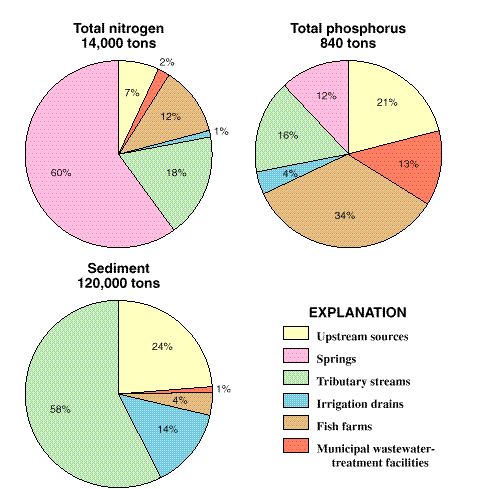
Sources of pollutants to the Snake River downstream from Milner Dam include irrigation return flows, agriculturally affected tributary streams, fish farms, and wastewater-treatment facilities [4]. Sources such as agriculture, food processing and other industries, and confined-animal feeding operations may not discharge directly to the Snake River; rather, pollutants from these sources are, in many instances, transported to the ground water and ultimately discharged to the Snake River. On the basis of data collected during the NAWQA study and by other agencies, contributions of nitrogen, phosphorus, and sediment to the Snake River between Milner Dam and King Hill were estimated for 1995 [4]. The estimates indicate that ground water discharging as springs supplied about 60 percent of the 14,000 tons of total nitrogen that entered the reach during 1995. Tributary streams and fish farms contributed 18 and 12 percent of the total nitrogen, respectively. Fish farms, tributary streams, and the Twin Falls wastewater-treatment facility contributed 34, 16, and 13 percent, respectively, of the 840 tons of total phosphorus entering the reach in 1995. Sources upstream from Milner Dam contributed 21 percent of the total phosphorus. About 120,000 tons of sediment entered the reach in 1995. The agriculturally affected tributaries--Rock Creek, Cedar Draw, Mud Creek, Deep Creek, Salmon Falls Creek, and the Malad River--contributed about 58 percent of the sediment input to the reach, and upstream sources and irrigation return flows contributed 24 and 14 percent, respectively.
The degraded conditions in the Snake River between Milner Dam and King Hill and increasing water-resource demands by user groups have raised public awareness about this reach of the river. Restoring and maintaining the water quality of the Snake River and protecting existing uses are recognized as important factors influencing the future economic and social well-being of the region. Simply reducing nutrient and sediment inputs to the river might not be sufficient to reverse the eutrophication process occurring in the Snake River downstream from Milner Dam. Future management strategies also might need to ensure that streamflows in the reach are sufficient to move nutrients and sediment downstream and to prevent future accumulations.
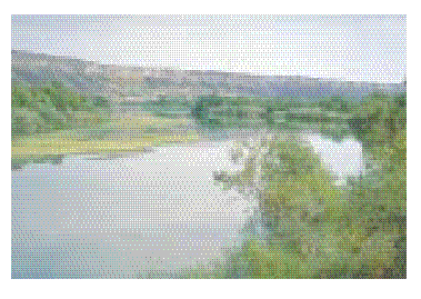
Along the north bank of the Snake River between Milner Dam and King Hill are 11 of the 65 springs in the United States that discharge more than 100 cubic feet per second. In addition to the use of spring water in fish hatcheries, the springs also are used for hydroelectric power production, drinking water for local residents, and habitat for native species of fish and endangered snails. In recent years, the amount of water discharging from the springs has declined as a result of increased ground-water withdrawals, more efficient irrigation practices which result in less recharge to the aquifer, and drought conditions (photograph © 1995 by W.H. Mullins and published with permission).
In 1995, springs provided 60 percent of the approximately 14,000 tons of nitrogen that entered the Snake River between Milner Dam and King Hill. Fish farms and Snake River water coming through Milner Dam (upstream sources) were the primary contributors of phosphorus in 1995. Agriculturally affected tributaries to the Snake River provided about 58 percent of the 120,000 tons of sediment entering the Snake River between Milner Dam and King Hill.