![]()
The Willamette Basin NAWQA Study Unit comprises the Willamette and Sandy River Basins in northwestern Oregon. The 12,000-square-mile basin is bordered on the west by the Coast Range, where elevations exceed 4,000 feet, and on the east by the Cascade Range, with several peaks higher than 10,000 feet. The interlying Willamette Valley, with elevations near sea level, is filled mostly with sediment of alluvial origin.
The Willamette River is the 13th largest river in the conterminous United States in terms of streamflow and produces more runoff per square mile than any of the larger rivers (Kammerer, 1990). The Sandy River Basin includes the Bull Run watershed, which has been Portland's primary drinking water supply for more than 100 years; it is one of the few surface supplies in the United States that the USEPA does not require to be filtered. The Willamette and Sandy Rivers are tributary to the Columbia River, which flows west to the Pacific Ocean along Oregon's northern border.
The Willamette Basin is drained by the Willamette and Sandy Rivers and includes all or parts of 13 counties (boundaries shown in yellow).
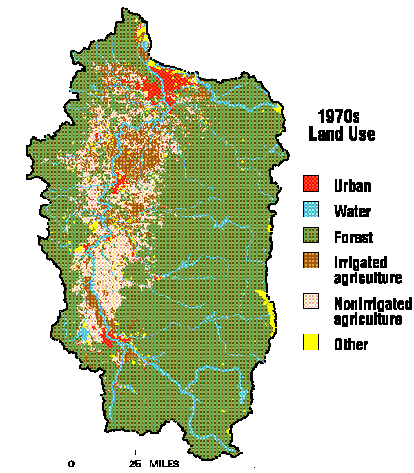
Land use in the Willamette Basin has been described based on 1970s high altitude aerial photography (U.S. Geological Survey, 1990) updated with 1990 census data (Hitt, 1994). Forested land (70 percent of the basin) dominates the foothills and mountains of the Coast and Cascade Ranges. Agricultural land is mostly cropland, comprises 22 percent of the basin, and is located predominantly in the Willamette Valley. About one-third of the agricultural land is irrigated (Oregon Water Resources Department, 1979; 1980; 1981), and most of this is adjacent to the main stem Willamette River in the southern basin or scattered throughout the northern valley. Urban land (6 percent of the basin) is located primarily in the valley along the main stem Willamette River. Other land uses and water account for less than 2 percent of the basin area.
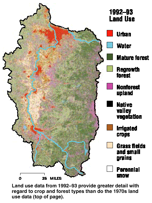
In contrast to the 1970s land use data described above, Landsat data collected during 1992-93 and analyzed as part of the present study provide considerably greater detail with regard to (1) crop types and native valley vegetation and (2) forest types and nonforest upland.
During 1992, the Willamette Basin accounted for 51 percent of Oregon's total gross farm sales. |
During 1992, the Willamette Basin accounted for 51 percent of Oregon's total gross farm sales and 58 percent of Oregon's crop sales (Oregon Agricultural Statistics Service, 1993). These sales came from nine counties that comprise most of the basin area, and were due to production of grass seed, wheat, hay, oats, corn, and many specialty crops.
| Rank | Acres | |
|---|---|---|
| 1 | 293,000 | |
| 2 | 173,000 | |
| 3 | 152,000 | |
| 4 | 62,200 | |
| 5 | 49,600 | |
| 6 | 35,500 | |
| 7 | 26,400 | |
| 8 | 25,000 | |
| 9 | 21,400 | |
| 10 | 17,000 | |
About 2 million people, or 70 percent of Oregon's population, lived in the Willamette Basin in 1990. |
About 2 million people, or 70 percent of Oregon's population, lived in the Willamette Basin in 1990 (Center for Population Research and Census, 1992). Portland, with 1.2 million people, is the State's largest metropolitan area. Population growth in the basin from 1990 to 1991 was about 3.5 percent and is expected to continue.
Land use data from the 1970s (left and above) indicate that 22 percent of the basin was agricultural and that the area of nonirrigated land was about twice the area of irrigated land.
Land use data from 1992-93 provide greater detail with regard to crop and forest types than do the 1970s land use data (top of page).
More than three-fourths of the water used in the Willamette Basin during 1990 was surface water (Broad and Collins, 1996). The largest single use was for irrigation of crops, such as berries, hops, mint, nursery stock, sugar beets, and vegetables (including beans, broccoli, cabbage, corn, garlic, onions, and squash). Public supply (serving cities, towns, mobile home parks, apartment complexes) was the second largest use; it consisted mostly of withdrawals from Cascade streams, including the Bull Run in the Sandy Basin and the Clackamas, Santiam, and McKenzie Rivers.
Estimated water withdrawals in 1990 were mostly from surface water. Irrigation was the largest single use.
More than three-fourths of the water used in the Willamette Basin during 1990 was surface water. |
The small amount of ground water used for public supply (10 percent of the total) came predominantly from alluvial aquifers located along Cascade streams or along the main stem Willamette River. Most commercial water use was by fish hatcheries, and most industrial use was by pulp-and-paper mills.
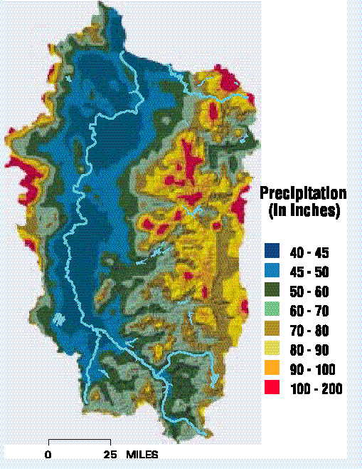
The Willamette Basin is characterized by cool, wet winters and warm, dry summers. About 70-80 percent of the annual precipitation falls from October through March, but less than 5 percent falls in July and August. Most precipitation falls as snow above about the 5,000-foot level of the Cascades; however, the Coast Range and Willamette Valley receive relatively little snow. Mean monthly air temperatures in the valley range from about 3-5oC during January to 17-20oC during August.
Although annual precipitation averaged 62 inches in the Willamette Basin during 1961-90, topography strongly influenced its distribution. Yearly amounts ranged from 40-50 inches in the valley to as much as 200 inches near the crests of the Coast and Cascade Ranges.
Streamflow in the Willamette Basin reflects the seasonal distribution of precipitation, with 60-85 percent of runoff occurring from October through March, but less than 10 percent occurring during July and August. Releases from 13 tributary reservoirs are managed for water quality enhancement by maintaining a flow of 6,000 cubic feet per second (ft3/s) in the Willamette River at Salem during summer months (U.S. Army Corps of Engineers, 1989).
About 70-80 percent of the annual precipitation falls from October through March, but less than 5 percent falls in July and August. |
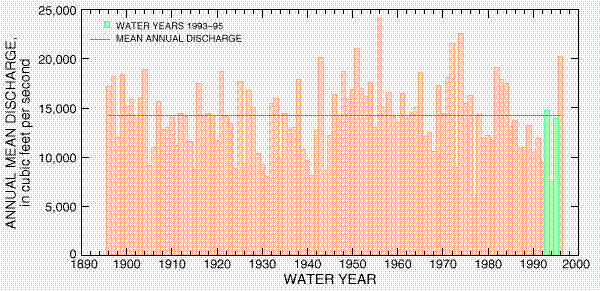
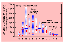
Mean annual discharge of the Willamette River near its mouth at Portland was 32,400 ft3/s during water years 1972-90. (A water year extends from October 1 of one year through September 30 of the following year and is designated by the calendar year in which it ends.) Typical monthly flows at Portland ranged from about 8,000 ft3/s in August to about 70,000 ft3/s in December. Recorded extreme flows were 4,200 ft3/s in July 1978 and 283,000 ft3/s in January 1974, although the river reached an estimated peak flow of 460,000 ft3/s during the flood of February 1996.
 (68,465 bytes)
Mean annual precipitation during 1961-90 was as high as 200 inches near the mountain crests, but the Willamette Valley received only 40-50 inches.
Hydrologic conditions during the intensive data collection phase (water years 1993-95) of the Willamette Basin NAWQA study were evaluated using discharge data for the Willamette River at Albany, about 20 miles south of Salem. This site has the longest continuous record in the basin and drains about 40 percent of its area. Annual mean discharges during water years 1993 and 1995 were about average, but discharge for water year 1994 was the second lowest on record. However, because streamflow at this site is regulated by nine tributary reservoirs, it may not strictly represent upstream hydrologic conditions.
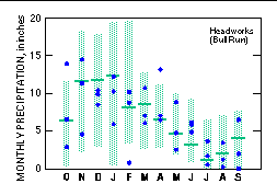
An analysis of precipitation data from five National Oceanic and Atmospheric Administration sites distributed throughout the basin generally corroborated results from the streamflow analysis. Total precipitation was about 5 percent below the water years 1961-90 average during water year 1993, and it was 32 percent below average during water year 1994. However, water year 1995 (18 percent above average) was slightly wetter than indicated by the streamflow data.
Annual mean discharges during water years 1993 and 1995 were about average, but discharge for water year 1994 was the second lowest on record. |
Annual mean discharges for the Willamette River at Albany indicate that water years 1993 and 1995 were typical of long term average conditions, but that discharge for water year 1994 was the second lowest on record.
Monthly conditions during water years 1993-95 often differed considerably from long-term average conditions. For example, precipitation and streamflow were above average during April 1993 when samples were collected from northern Willamette Basin streams to determine nutrient and pesticide concentrations during a stormflow event following fertilizer and pesticide applications. On the other hand, spring 1994 precipitation and streamflow generally were below average (particularly during May) when samples were collected to evaluate pesticide and nutrient concentrations in southern Willamette Basin streams, where crop types differ somewhat from those in the northern Willamette Basin.
Streamflows were about average during July-October of all 3 water years. During these periods, many streams were wadable, most streams had stable beds, and conditions were ideal for collection of streambed sediment and aquatic biota and for measurement of aquatic habitat characteristics.
Monthly precipitation and monthly mean discharges show that conditions during water years 1993-95 (dots) usually were considerably above or below average (horizontal bars).