![]()
Radon, which can cause lung cancer, is a radioactive, odorless, and chemically inert gas that occurs naturally in the air, soil, and ground water. Radon is a decay product of radium, which in turn is a decay product of uranium. Rocks break down mechanically and chemically to form sediments that contain differing amounts of uranium, depending on the source rocks. The higher the uranium concentration is in the source rocks, the greater the chances are for radon in the air, soil, or ground water. Other potential sources of uranium in the environment are improper disposal of uranium mining waste and nuclear fuel processing, combustion of wood and fossil fuels, or roasting of rocks in metal extraction or cement industries.
Radon in ground water affects radon concentrations in indoor air in homes because it escapes to the indoor air as people use water. Open water-distribution systems allow ground water to aerate and radon to escape. In small, closed water-distribution systems with short transit times, radon cannot escape from the system; therefore, it escapes into the indoor air. Research suggests that ingestion of water with high radon concentrations also may pose risks, although these risks are believed to be much lower than those from inhalation of radon.
Until late 1996, the EPA had proposed an MCL of 300 pCi/L for radon in drinking water. However, this proposed MCL was withdrawn by EPA for further evaluation; thus, no proposed MCL currently exists. Radon concentrations measured during this study were larger than the previously proposed MCL in 57 percent of the wells.
Radon concentrations were equal to or greater than 512 pCi/L in water from all shallow wells sampled in the San Luis Valley land-use study (table 8). Although the range in concentration is not as large in the Albuquerque land-use study, values for seven samples were greater than 300 pCi/L. In the Rincon Valley land-use study, only three samples exceeded 300 pCi/L. The largest range in concentration was from the aquifer subunit survey (table 8), which also had the largest radon concentration measured, 2,300 pCi/L. More than one-half the wells sampled from the deeper aquifer have water with a radon concentration greater than 300 pCi/L.
On the basis of these reported concentrations, it is apparent that radon in both shallow and deeper ground water is a potential human health concern. The likely source for the elevated concentrations of dissolved radon in ground water is from naturally occurring minerals that contain uranium in the sediments that compose the aquifer. There is no direct evidence that land use has affected radon concentrations in shallow ground water in the Study Unit.
A knowledge of the dissolved-solids concentration in irrigation water can be useful to water users in determining application rates for different soil and crop types and drainage requirements. Dissolved-solids concentration is a measure of the dissolved constituents in water and is commonly used as a general indicator of salinity or water quality. Although dissolved-solids concentration has an important effect on the use of irrigation water, there is no Federal or State standard.
Evaporation, transpiration, and dissolution of minerals are the three major processes that result in an increase of dissolved-solids concentration. All of these processes are major contributors to the increases in dissolved solids measured in the Study Unit.
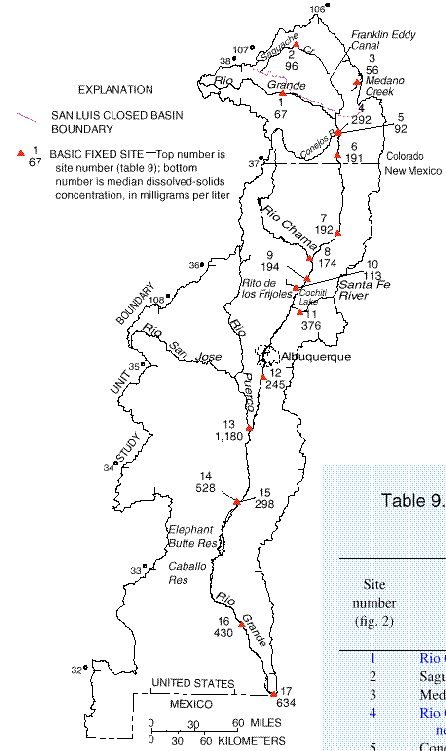
In general, the dissolved-solids concentration in surface water increases with the length of time that the water has been in the hydrologic system. This is illustrated by data from the Basic-Fixed-Site network. The smaller dissolved-solids concentrations are in the northern part of the study area and generally represent runoff derived from snowmelt or water that has been subjected to limited irrigation use (fig. 3 and table 9). The median dissolved-solids concentration for main-stem sites increases downstream from site 1 to site 17, with the exception of site 4 (sites are highlighted in blue in table 9). The cause of the anomalously high median concentration at site 4 is unknown. Possible causes are ground-water recharge to the Rio Grande, introduction of ground water pumped from the sump area of the Closed Basin, or discharge from the Alamosa WWTP. The downstream increase in dissolved-solids concentration at the Basic Fixed Sites illustrates the effect that evaporation, transpiration, and dissolution of minerals can have on water as it moves through the system. All three of these processes occur extensively along the Rio Grande as a result of the most significant water use, irrigation.
The largest median dissolved-solids concentration for the Basic Fixed Sites was at site 13 on the Rio Puerco. The Rio Puerco, a typical tributary to the Rio Grande in the southern part of the basin, was the only ephemeral stream sampled in this area. It illustrates the importance that ephemeral streams in semiarid environments have on dissolved-solids concentrations, particularly in load calculations. In one or two storm-runoff events from these tributaries, most of the calculated dissolved-solids load for the year can occur.
Figure 3.--Median dissolved-solids concentrations at Basic Fixed Sites.
|
Site | |||
|---|---|---|---|
|
Rio Grande above mouth of Trinchera Creek, near Lasauses, Colo. |
|||
|
Rito de los Frijoles in Bandelier National Monument, N. Mex. |
|||