![]()
Islands and bars of the Platte River east of Grand Island have become densely wooded.
The Platte River Valley has been called "the foremost physical geographic feature of South Central Nebraska" [24]. The river bears little resemblance to the one that led tens of thousands of Native Americans, trappers, and settlers westward.
Though the Platte Valley still serves as a major overland interstate and rail artery, the river and its tributaries also are situated along another "highway." This corridor runs north-south, but instead of settlers, it is one of the major transcontinental routes for migratory birds and waterfowl. The Central Flyway serves as a conduit to bring half a million sandhill cranes, endangered whooping cranes, and vast numbers of other migratory species through the Platte Valley each year. These birds use the Platte Valley for nesting and to replenish their strength for their semi-annual journey. The channels of the Platte also provide habitat for more than 50 species of fish [25].
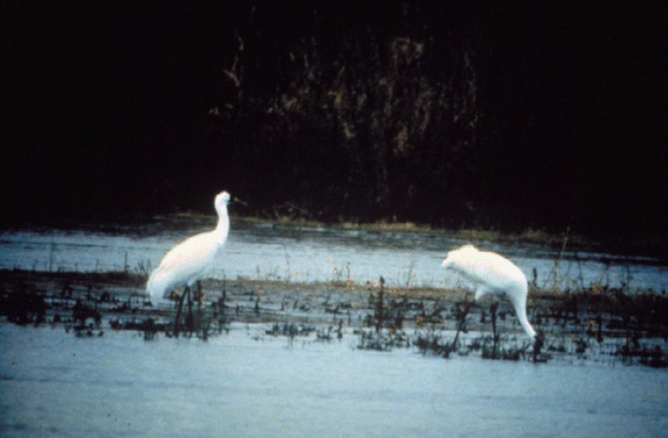
Endangered whooping cranes in the Platte River.
Physical characteristics of a river can be used to assess habitat for biota. These characteristics at a basin scale include basin shape, area, percentage of the basin contributing to runoff, the frequency and timing of floods, and land-use features [26]. Stream segment characteristics include streamflow, the shape of the channel, the stream stage at overflow into the flood plains, and sinuosity (or how curved the river is). Stream reach characteristics include the depth, width, and velocity of the stream, composition of the riverbed, and the available habitat. Different species of plants and animals prefer and are limited to living in the rivers and streams where these physical characteristics are compatible with their preferences and tolerances.
Streamflow regulation on the North Platte River has reduced the magnitude of spring floods in the main stem of the Platte River and, along with possible long-term climate change, has resulted in substantial channel-width reductions [25]. Since the completion of the last major dam on the North Platte River more than 50 years ago, channel width has been reduced by 90 percent immediately downstream from the confluence of the North and South Platte Rivers and from 40 to 60 percent in the middle reaches of the river [27]. Abandoned channels of the stream are now colonized by woodlands [28]. Nearly all researchers agree that birds that use the wide, active channels of the Platte River will lose valuable habitat with further channel narrowing.
The Central Nebraska Basins Study Unit team determined that, though the channel width appears to be stabilized at about 10 percent of its former width near Brady, the nature of its shape has changed markedly. Where the river was once a fairly straight and highly braided stream, it is now in the process of becoming a meandering river.
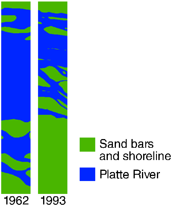
Although the channel near Grand Island has retained some braided characteristics, it continues to narrow. Since 1962, approximately one-third of the channel width has been lost [25]. Evidence suggests that the forces reshaping the Platte River are progressing at differing rates along the river. W.C. Johnson [29] found that since the 1960s, open channel and woodland areas in most reaches of the Platte River have remained relatively stable. Johnson suggests that channel narrowing downstream from Grand Island has continued because of the accumulation of sediment released by vegetation clearing above the reach. Regardless of the relative effects of water development and vegetation clearing on channel narrowing, it is apparent that the river in the reach below Grand Island is still engaged in the reshaping process and further changes can be expected.
Channel narrowing of the Platte River near Grand Island.Species must adapt to change in habitat. Native species, such as cranes, use open water and barren sandbars for roosting at night. Other smaller migratory birds, such as the piping plover and interior least tern, use barren sandbars as nesting areas. The width of the Platte River near Grand Island has decreased. Many sandbars have become permanently vegetated in the past 30 years, changing the habitat in this reach of the Platte River. |
Traditionally, the Platte Valley has served the sandhill cranes and the endangered whooping cranes as a secure place to rest while they feed [30]. Crane populations are relatively stable, but the habitat that cranes prefer for roosting has been substantially reduced. These habitat areas still exist near Grand Island and are known as the Critical Habitat Reach of the Platte River. The cranes prefer to roost in unobstructed channel areas that are greater than 450 feet (ft) wide, and they are rarely seen where the channel is less than 150 ft wide [31]. The same number of cranes in a smaller area results in crowding. High population densities brings the threat of cholera and other diseases to the bird populations [32]. Tens of thousands of cranes have been killed by tornadoes and storms passing over areas with high crane populations. Other birds, such as the endangered piping plover and threatened least tern, build their nests on the barren sandbars of the river. Channel narrowing also has reduced habitat for these species.
Sandhill cranes prefer unobstructed river channels as a roosting site.
R.E. Johnson [33] described Nebraska fish distribution from 1939 to 1940. Goldowitz [34] demonstrated that the number of fish species had declined through 1995 in the reaches of the Platte River with the greatest channel-width reductions. R.E. Johnson collected fish using seines and 2-person crews, whereas Goldowitz collected fish with a combination of seining and electrofishing with a similar crew size. The Study Unit team used electrofishing with 4-5 personnel, resulting in 200 to 300 percent higher species catches at Brady and up to 40 percent higher species catches at Grand Island than either the R.E. Johnson or the Goldowitz surveys. Even though these sites had highly diverse fish communities, the Central Nebraska Basins Study Unit team, like Goldowitz, noted an absence of some native minnows. The brassy minnow, plains minnow, western silvery minnow, speckled chub, and flathead chub were not found during the Central Nebraska Basins study [22] in 1993 or 1994 at Grand Island, but were recorded by R.E. Johnson in the 1939 or 1940 collections. In addition, the number of moderately tolerant species, such as catfish, bullheads, mosquitofish, and the brook silverside, increased in both the Central Nebraska Basins study and the Goldowitz survey. All species found by the Study Unit team that were exclusive of the Goldowitz and R.E. Johnson surveys were classified as either tolerant species or moderately tolerant species, with the exception of the intolerant longnose dace.
Researchers of similar streams in Kansas had similar results [35]. Where dewatering and habitat destruction have occurred along streams, fish communities have changed in favor of more tolerant native and introduced fish. The native plains minnow, cited as the most abundant and widespread minnow in the central plains region [36], was absent in collections of the Central Nebraska Basins study in 1993 and 1994.
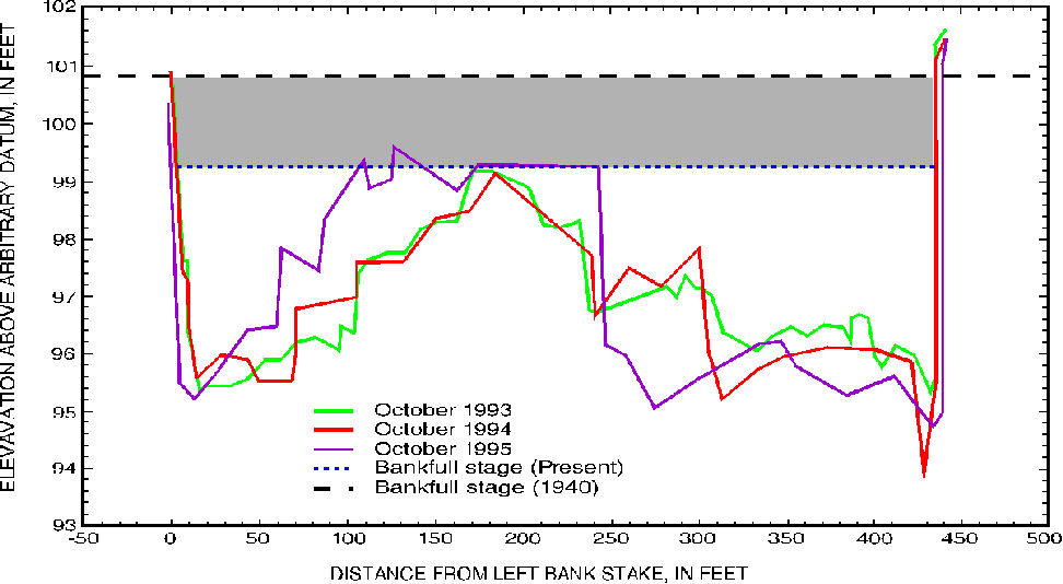
One reason that some fish species are absent or in decline may be a scarcity of critical habitats. Critical habitats are those that are essential for certain species during breeding and early stages of growth. Flood plains may be a critical habitat for many aquatic species. The flood plain is the area adjacent to streams that is inundated on a recurrence interval of about every 2 years. The Platte River has a historical flood plain extending up to hundreds of feet from the bank; however, the current regulated flows infrequently overflow the bank onto the flood plains. A study by Williams [27] of the Platte River has shown that the streambed has been lowered by 1.6 ft near Brady as a result of flow regulation. The Study Unit team confirmed this finding by repeated surveys at the Brady site that showed bankfull flows and the top of a large sandbar that were 1.6 ft below the former flood plain (see figure). A new flood plain has become established in the incised channel that is only a few feet wide, leaving only a small fraction of the flood plain available for habitat on a frequent basis [25].
Bankfull-flow elevation at the North Channel of the Platte River at Brady is lower today than in 1940.
--Robert B. Swanson and Ronald B. Zelt