|
 (52,599 bytes) (52,599 bytes)
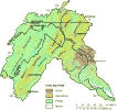
Figure 1. Generalized land use in the Potomac River Basin (modified from Vogelmann and others, 1997; and Hitt, 1994). The basin is predominantly forested, with smaller areas of agriculture and urban development.
|
 (3,906 bytes) (3,906 bytes)
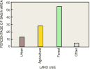
Figure 2. Major land use in the Potomac River Basin, 1990-94 (modified from Vogelmann and others, 1997; and Hitt, 1994)
|
|
 (33,922 bytes) (33,922 bytes)
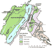
Figure 3. Generalized geology and physiography in the Potomac River Basin (modified from Fenneman and Johnson, 1946; Milici and others, 1963; Cardwell and others, 1968; Cleaves and others, 1968; King and Beikman, 1974; and Berg, 1980). Unconsolidated deposits occur mainly in the Coastal Plain and in isolated areas of alluvial deposits along stream channels in the Valley and Ridge. Crystalline rocks underlie only the Piedmont and Blue Ridge in the central and eastern parts of the basin. The entire basin west of the Blue Ridge is underlain by sedimentary rocks; these rocks are mainly siliciclastic, with areas of extensive carbonate rocks, particularly in the Great Valley.
|
 (14,796 bytes) (14,796 bytes)
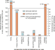
Figure 4. Freshwater withdrawals in the Potomac River Basin (data from H.A. Perlman, U.S. Geological Survey, written commun., 1993). Most of the surface water withdrawn from the Potomac River Basin is used for the generation of electricity and for public supply. Ground water in the basin is used mainly for domestic and public supply. Water is also withdrawn from the basin for various commercial, industrial, and agricultural purposes.
|