USGS

Water Quality in the Potomac River Basin, Maryland, Pennsylvania, Virginia, West Virginia, and the District of Columbia, 1992-96

Table of contents || Previous section || Next section || Glossary


HYDROLOGIC CONDITIONS IN THE POTOMAC RIVER BASIN, 1992-96

Bar chart/plot: precipitation, water level, and flow, 1991-95 (36,764 bytes)

Figure 5. Streamflow, ground-water levels, and precipitation at selected sites in the Potomac River Basin. Streamflow and ground-water levels in the basin typically vary seasonally with rates of precipitation and evapotranspiration.

Bar chart: annual mean flow, water years 1992-96 (12,620 bytes)

Figure 6. Mean annual streamflow of the Potomac River at Washington, D.C. Streamflow can vary considerably from year to year. Flow of the Potomac River at Washington, D.C., did not exceed flood level in 1992 or 1995; however, occasional flooding did occur in 1993, 1994, and 1996 and locally on some tributaries throughout the study period. Floods occurred mostly during the months of winter and early spring. Near-drought conditions occurred for short periods in the late summer or fall of 1992, 1993, and 1995.

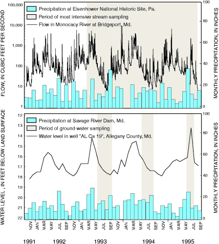
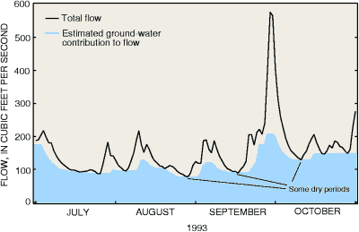
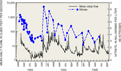
Hydrologic conditions affect the quality of streams and ground water in the Potomac River Basin. Fertilizers, pesticides, and other chemicals that are applied to the land surface may infiltrate to ground water or run off to streams during rainfall depending on the season, soil properties, and the intensity and duration of precipitation. During dry periods, flow in most streams of the Potomac River Basin is sustained by discharge from ground water (fig. 7) and streamwater quality is similar to that of ground water. When flows are elevated during storms, streams of the basin typically become concentrated in chemicals that are washed from the land (fig. 8), although streams in some areas may become diluted.

Plot: Total flow and estimated ground-water contribution to flow, 1993 (8,864 bytes)

Figure 7. Total streamflow and estimated ground-water contribution to flow in the South Branch Potomac River near Springfield, W. Va., during part of 1993. Ground water contributes virtually all flow to the river during dry periods but some of the flow during wetter periods.

Plot: Mean daily flow and nitrate concentration, 1993-95 (11,756 bytes)

Figure 8. Streamflow and nitrate concentrations in Muddy Creek at Mount Clinton, Va. Nitrate concentrations are typically higher during periods of high flow than during drier periods.


U.S. Geological Survey Circular 1166

Table of contents || Previous section || Next section || Glossary

Suggested citation:
Ator, S.W., Blomquist, J.D., Brakebill, J.W., Denis, J.M., Ferrari, M.J., Miller, C.V., and Zappia, H., 1998, Water Quality in the Potomac River Basin, Maryland, Pennsylvania, Virginia, West Virginia, and the District of Columbia, 1992-96: U.S. Geological Survey Circular 1166, on line at <URL: https://water.usgs.gov/pubs/circ1166>, updated June 10, 1998 .

This page is a subpage of <URL:http://water.usgs.gov/pubs/circ1166>
Email questions and comments to GS-W_NAWQA_Outreach@usgs.gov
Last modified: Tue Jun 30 12:39:07 1998