
The environmental setting is an integration of many physical and hydrologic features and human activities. Physical and hydrologic features include location, topography, physiography, geology, soils, climate, natural vegetation, streams, and aquifers. A classification of Integrated Land Resource Units characterizes the physical and hydrologic features (Ulery and others, 1993). Past and current human activities, including construction of reservoirs, urbanization, farming, ranching, and oil and gas production, have greatly altered the natural environment in the Trinity River Basin.
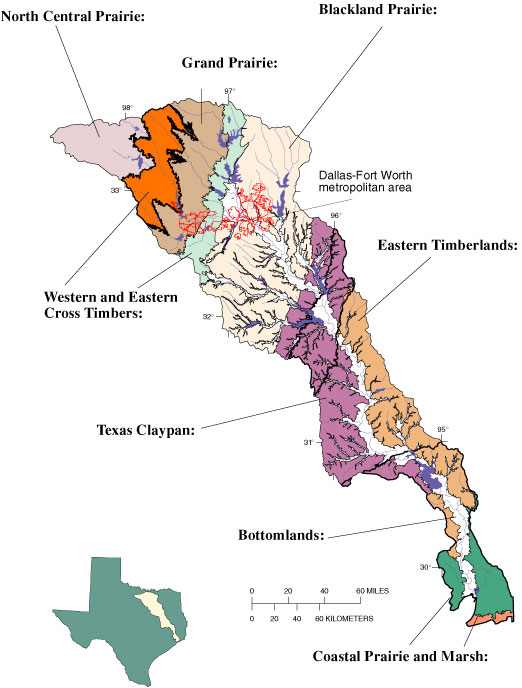
Grand Prairie: The terrain is characterized by nearly level plains and rolling hills and is naturally devoid of trees except along streams. Much of Fort Worth is located on the Grand Prairie.
North Central Prairie: The terrain is nearly level to hilly and covered with natural vegetation, which mostly is prairie grass. However, brush has encroached into much of the area. Substantial amounts of oil and gas are produced in the area. The principal agricultural product is cattle.
Western and Eastern Cross Timbers: The terrain is hilly and oak trees are a prominent feature, especially when contrasted with prairies immediately to the east and west of each of these areas. The area is suitable for raising cattle. The Eastern Cross Timbers between Fort Worth and Dallas has been urbanized.
Blackland Prairie: The terrain varies from nearly level to rolling hills, has very fertile soils, and, in its natural state, is largely a grassy plain except along the streams. Much of the area has been cultivated in the past; however, a large part of the cultivated acreage has been converted back to pasture for cattle grazing. Much of the Dallas metropolitan area is on the Blackland Prairie.
Texas Claypan: The terrain is mostly rolling hills. The natural vegetation is mostly prairie grasses and oaks. Agriculture is dominated by cattle ranching. Lignite coal is mined locally and is used to fuel nearby electric power plants.
Eastern Timberlands: The terrain varies from a rolling plain to gently rolling hills. The area is noted for piney woods and produces nearly all the commercial timber in Texas. The area also is a major producer of oil and gas. Perennial streams are prevalent.
Coastal Prairie and Marsh: The area is very flat. Natural vegetation is prairie grasses with stands of hardwoods and pines. The area is extensively cultivated for growing rice. However, much of the cultivated acreage is being converted to pasture for cattle grazing. Oil and gas also are produced in the area.
Bottomlands: The Bottomlands lie along the Trinity River and the lower reaches of major tributaries. Many reservoirs in the Trinity River Basin have greatly reduced the historical magnitude and frequency of floods in the Bottomlands.
Surface water, almost entirely from reservoirs, supplies more than 90 percent of the water used in the basin. With the large population and concentration of businesses and industries in the Dallas-Fort Worth area, many reservoirs have been built for water supply and flood protection. Relatively little water is used for irrigating crops. Aquifers outcrop in all or parts of the Western and Eastern Cross Timbers, Eastern Timberlands, Texas Claypan, and Coastal Prairie and Marsh. Ground water is used for municipal and domestic supply in some of the smaller towns and in rural areas.
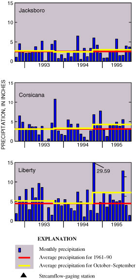
Hydrologic conditions in the Trinity River Basin are best characterized by precipitation and streamflow. Precipitation varies considerably across the Study Unit, with average annual rainfall ranging from about 27 inches in the northwestern part to about 52 inches in the southeastern part. Streamflow generally is proportional to precipitation and the size of the watershed, except downstream from reservoirs and point sources such as wastewater-treatment plants. To characterize the hydrologic conditions in the Trinity River Basin during the March 1993-September 1995 intensive sampling phase, monthly precipitation and daily streamflow from October 1992 to September 1995 at selected stations are graphed and interpreted.
Precipitation: Essentially all the precipitation in the Trinity River Basin is rain. At the three selected precipitation sites across the basin, rainfall was about normal in 1993 and 1994 and about one-third greater than normal in 1995. The greatest flooding occurred in October 1994 in the southern part of the study area where 18.5 inches was recorded in 1 day and more than 26 inches in 3 days. The rainfall data suggest that water-quality data collected during and shortly after the October 1994 flood would reflect unusual hydrologic conditions.
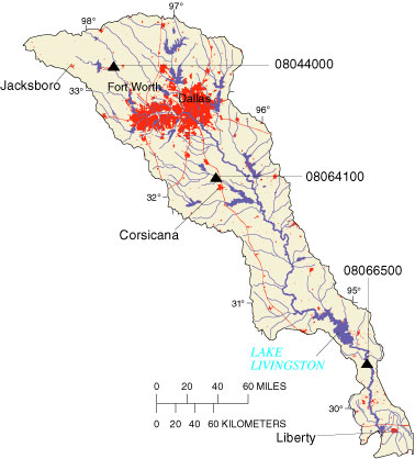
Streamflow: Two stream configurations are in the Trinity River Basin; one is tributary streams and the other is the main stem of the Trinity River. Much of the water in tributary streams is captured by reservoirs and becomes a water supply. Water in the main stem provides water to Lake Livingston, also used for water supply, and to coastal bays and estuaries. The hydrographs for two tributaries, Big Sandy Creek and Chambers Creek, show streamflow decreases to relatively low levels each year during the summer. Flow in the Trinity River at Romayor, about 70 miles upstream from the mouth, is controlled by releases from Lake Livingston. The hydrographs indicate that data collected during the sampling period are representative of normal conditions, except during 1995 in the lower reach of the Trinity River when flows were well above average.
 |
 |
Reservoirs: There are 22 reservoirs in the Trinity River Basin with more than 10,000 acre-feet of storage and hundreds of smaller reservoirs, mostly flood-control structures built by the Natural Resources Conservation Service (Ulery and others, 1993). These reservoirs have an appreciable effect on streamflow and water quality in the basin. They tend to increase base flow in streams by releasing stored water during dry periods. They tend to reduce flood peaks by storing floodwaters. They affect water quality by trapping sediment and associated nutrients and contaminants and by altering the stream habitat both in the flooded lake area and downstream.