
Hydrologic Benchmark Network Stations in the Midwestern U.S. 1963-95 (USGS Circular 1173-B)
|
|
|
|
|
Big Creek at Pollock, Louisiana (Station 07373000)
To download a printer friendly PDF version of this information click here.
This report details one of the approximately 50 stations in the Hydrologic Benchmark Network (HBN) described in the four-volume U.S. Geological Survey Circular 1173. The suggested citation for the information on this page is:
|
Mast, M.A., and Turk, J.T., 1999, Environmental characteristics and water quality of Hydrologic Benchmark Network stations in the Midwestern United States, 1963-95: U.S. Geological Survey Circular 1173-B, 130 p. |
All of the tables and figures are numbered as they appear in each circular. Use the navigation bar above to view the abstract, introduction and methods for the entire circular, as well as a map and list of all of the HBN sites. Use the table of contents below to view the information on this particular station.
|
Table of Contents |
| 1. Site Characteristics and Land Use |
| 2. Historical Water Quality Data and Time-Series Trends |
| 3. Synoptic Water Quality Data |
Site Characteristics and Land Use
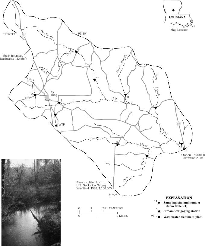
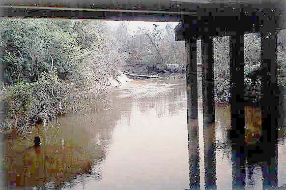
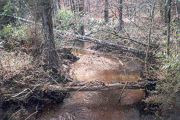
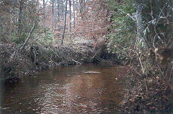
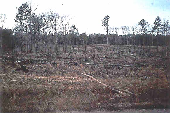
The Big Creek HBN Basin is located in the Alluvial Plains region of the Coastal Plain physiographic province in central Louisiana (Figure 10. Map showing study area in the Big Creek Basin and photograph of the Haw Creek tributary). The 132-km² basin ranges in elevation from 23 to 80 m and drains a landscape dissected by numerous small streams with narrow, gently sloping ridgetops and steep-sided hillslopes. The USGS gaging station is located 1.3 km north of the town of Pollock, La., at latitude 31×32'10'' and longitude 92×24'30''. Big Creek flows southeast into the Little River, a tributary of the Atchafalaya River, and has a channel length of about 16 km upstream from the gaging station and an average stream gradient of 2.1 m/km. The main channel is perennial, and mean monthly discharge varies from a minimum of 0.71 m³/s in August to a maximum of 3.1 m³/s in February. Average annual runoff from the basin was 44 cm from 1943 through 1995 (Garrison and others, 1996). High infiltration rates and substantial ground-water storage result in well-sustained, constant base flows during dry months of the year. The climate is subtropical and is characterized by frequent and sometimes abrupt changes in weather. Average daily air temperatures range from 8.2×C in January to 27.8×C in July (Kilpatrick and others, 1986). Precipitation averages 148 cm annually and is slightly greater in the winter and the spring than in the summer and the fall (Kilpatrick and others, 1986). Average annual snowfall is less than 3 cm and only rarely are there days in winter when the air temperature does not rise above freezing.
 |
The Big Creek Basin is in the Outer Coastal Plain Mixed Forest ecoregion and is covered by a subclimax pine forest, which has an understory of grasses and sedges (Bailey and others, 1994). Before European settlement, the vegetation was dominated by longleaf pine forests; however, past management practices and the exclusion of wildfire have eliminated most of this native ecosystem. Forest cover presently consists of 75 percent yellow pine (loblolly, shortleaf, and slash pines) and about 25 percent longleaf pine. Pine forests are interspersed with hardwoods and flowering species, such as dogwoods, redbud, and magnolia. Vegetation along the flood plain is dominated by hardwoods, including hickory, cypress, oak, and gum. Forests in the Big Creek Basin were heavily affected by the southern pine beetle epidemic in the mid-1980's. Most soils in the basin are classified as Ultisols (Paleudults) and are mapped in the Smithdale-Ruston soil association, which includes well- drained soils developed in terrace deposits of Quaternary age (Kilpatrick and others, 1986). The Ruston soils develop on narrow ridgetops, and the Smithdale soils are on steeper side slopes. A typical soil in this association has a brown surface layer of fine sandy loam as much as 15 cm thick overlying a yellowish-red subsoil of sand clay loam that extends to 190 cm. These soils are typically acidic (pH 4.5 to 5.5), have low cation-exchange capacities (7 to 13 meq/100 g), and high concentrations of exchangeable aluminum (Kilpatrick and others, 1986). The predominant clay minerals in these soils are kaolinite and vermiculite.
The basin is underlain by gently dipping terraces of Pleistocene age that were deposited by large braided river complexes during interglacial periods (Maher, 1941). The terrace deposits consist of silty clays, sands, and gravels that range in color from mottled pink to reddish brown in fresh exposures to deep red or orange in weathered exposures (Fisk, 1938). The sediments range from 15 to 30 m in thickness and overlie the Catahoula Formation of Miocene age. The Catahoula Formation consists of alternating beds of sand, silt, and clay deposited under predominantly non-marine conditions (Martin and Whiteman, 1986). The Catahoula Formation forms an important aquifer in Louisiana; however, most domestic wells in Grant Parish are completed in the overlying terrace deposits (Gaydos and others, 1973).
 |
The Big Creek Basin drains the central part of Grant Parish in central Louisiana and is within the boundaries of the Catahoula Ranger District of the Kisatchie National Forest. About 44 percent of land in the basin is privately owned (John Novosad, U.S. Department of Agriculture Forest Service, written commun., 1997). Privately owned land is concentrated along the main channel of Big Creek and the Dyson Creek and Dry Prong tributaries, and about 80 percent is owned by large timber companies (U.S. Department of Agriculture, 1985a). A dense network of forest roads provides access to most areas of the basin. Roads tend to follow the ridgelines rather than parallel the drainages.
Land cover in the basin is about 90 percent forest, 7 percent agricultural, and 3 percent residential (John Novosad, U.S. Department of Agriculture Forest Service, written commun., 1997). The primary land-use activities on National Forest and on private land are timber harvesting and livestock grazing. National Forests in the basin are managed on an even-aged basis with 120-year rotations for longleaf pine and 100-year rotations for shortleaf pine and hardwoods. During the past 10 years, about 10 percent of National Forest land in the basin has been clearcut, and 20 percent has been treated by intermediate cuts (Finnis Harris, U.S. Department of Agriculture Forest Service, written commun., 1997). The Forest Service also has a controlled grazing program and issues grazing permits in areas dominated by longleaf and yellow pine forest types. Grazing on forest land in the basin presently is limited to about 40 head of cattle on about 280 ha (Finnis Harris, written commun., 1997). Other human-related features in the basin include a dense network of roads, the community of Dry Prong (population 380), a few gravel pits, several rural residences and small farms, stock ponds, and a gas pipeline and pumping station at the head of Flem Branch. The town of Dry Prong has a wastewater-treatment facility that discharges into the headwaters of Big Creek. Most residents obtain domestic water from ground-water wells in the terrace deposits. There have been no major changes in land use in the basin since the establishment of the HBN site, other than a small increase in residential population and slight decrease in timber harvesting on National Forest lands (John Novosad, U.S. Department of Agriculture Forest Service, written commun., 1997).
Historical Water-Quality Data and Time-Series Trends
The data set for the Big Creek HBN Station analyzed for this report includes 233 water-quality samples that were collected from March 1967 through August 1995. Sampling frequency was monthly from 1968 through 1982 and quarterly from 1983 through 1995. Water-quality samples in the early part of the period of record were analyzed at a USGS laboratory in Baton Rouge, La., which analyzed surface- water samples until 1973 (Durum, 1978). After establishment of the central laboratory system, samples were analyzed at a laboratory in Atlanta, Ga., from 1973 through 1985 and at the NWQL in Arvada, Colo., from 1986 through 1995. Daily discharge records for Big Creek (station 07373000) are available beginning in January 1942. Records of daily water temperature at the gaging station are available from October 1964 through September 1973 and from October 1974 through September 1976.
 |
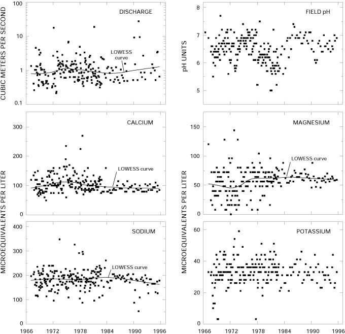
Calculated ion balances for 224 samples with complete major-ion analyses are shown in Figures 11a.and 11b. Temporal variation of discharge, field pH, major dissolved constituents, and ion balance at Big Creek, Louisiana. Ion balances ranged from -18 to 17 percent, and 95 percent of samples had values in the ±10 percent range, indicating that the analytical measurements were of good quality. The average ion balance for all samples was -0.1 percent, indicating that unmeasured constituents, such as organic anions, did not contribute substantially to the ion balance of stream water at this station. Time-series plots of the major constituents were inspected for evidence of method-related effects (fig. 11). Several patterns are evident at this station; for example, calcium, magnesium, and sodium concentrations had noticeable decreases in data scatter after 1983. Procedural changes that may have affected the concentration patterns of these constituents include a change in the analytical method for cations and trace metals in 1983 (Office of Water Quality Technical Memorandum No. 82.18, National Water-Quality Networks, issued September 28, 1982, at URL http://water.usgs.gov/admin/memo/, accessed 1997) and a change in the NWQL in 1985. Some of this variation also may be related to the decrease in sampling frequency after 1983. Several patterns also are apparent in the sulfate data. For example, lower than average concentrations were more common in the late 1960's and in the early 1970's, and higher than average concentrations were apparent in the late 1970's and the 1980's. The low concentrations in the early part of the period of record are coincident with the period when samples were analyzed at the USGS laboratory in Baton Rouge, La. The pattern in the latter part of the period of record may be an artifact of different methods used to analyze sulfate including a colorimetric method, which was used between 1976 and 1984; a turbidimetric method, which was used from 1983 through 1989; and ion chromatography, which was used after 1990. Another notable pattern in figure 11 is the apparent decrease in ion balance beginning in the mid-1980's. The cause of this decrease could not be identified, although it is coincident with a switch to the NWQL in Arvada, Colo., that occurred in 1985.
Median concentrations and ranges of major constituents in stream water at the Big Creek Station and VWM concentrations in wet-only deposition measured at the NADP Southeast Research Station are listed in table 18. Precipitation chemistry at the NADP station, which is located about 220 km east of the HBN station, was dilute and slightly acidic with a VWM pH of 4.8 for 13 years of record. The predominant cations were hydrogen, sodium, and ammonium, which accounted for 33, 25, and 23 percent of the total cation charge, respectively. The predominant anions were sulfate, which contributed 47 percent of the anion charge, and chloride and nitrate, which contributed 29 and 24 percent, respectively. These results indicate that precipitation at the nearby NADP station may be affected by anthropogenic emissions of sulfur and nitrogen compounds, which cause acid rain, as well as salt from marine aerosols.
Table 18. Minimum, first quartile, median, third quartile, and maximum values of physical properties and major dissolved constituents measured in water-quality samples from Big Creek, Louisiana, March 1967 through August 1995, and volume-weighted mean concentrations in wet precipitation collected at the Southeast Research Station, Louisiana
[Concentrations in units of microequivalents per liter, discharge in cubic meters per second, specific conductance in microsiemens per centimeter at 25 degrees Celsius, pH in standard units, and silica in micromoles per liter; n, number of stream samples; VWM, volume-weighted mean; inst., instantaneous; spec. cond., specific conductance; <, less than; --, not reported]
|
Parameter |
Stream Water |
Precipitation VWMa |
|||||
|
Minimum |
First quartile |
Median |
Third quartile |
Maximum |
n |
||
| Discharge, inst. |
0.21 |
0.54 |
0.89 |
1.42 |
27 |
232 |
-- |
| Spec. cond., field |
24 |
37 |
39 |
42 |
59 |
231 |
12 |
| pH, field |
5.0 |
6.2 |
6.5 |
6.8 |
7.7 |
233 |
4.8b |
| Calcium |
50 |
85 |
100 |
120 |
270 |
229 |
4.8 |
| Magnesium |
8.0 |
50 |
58 |
74 |
150 |
228 |
3.3 |
| Sodium |
52 |
170 |
180 |
200 |
350 |
231 |
12 |
| Potassium |
<2.6 |
28 |
33 |
38 |
59 |
232 |
.7 |
| Ammonium |
<.7 |
1.1 |
2.1 |
4.8 |
50 |
75 |
11 |
| Alkalinity, laboratory |
60 |
200 |
220 |
260 |
420 |
231 |
-- |
| Sulfate |
<2.1 |
23 |
42 |
63 |
150 |
231 |
23 |
| Chloride |
23 |
110 |
120 |
130 |
230 |
231 |
14 |
| Nitrite plus nitrate |
<.7 |
<7.1 |
7.1 |
7.1 |
43 |
147 |
12c |
| Silica |
75 |
270 |
300 |
330 |
430 |
233 |
-- |
a Data are volume-weighted mean concentrations for 1983-95.
b Laboratory pH.
c Nitrate only.
Stream water in Big Creek is dilute and weakly buffered; specific conductance ranged from 24 to 59 mS/cm, and alkalinity was between 60 and 420 meq/L (table 18). The major cations in stream water were sodium and calcium, and the major anions were bicarbonate and chloride. The low concentrations of the weathering-derived solutes, particularly bicarbonate, are attributed to the lack of weatherable minerals in the underlying Pleistocene
 |
The solute composition of stream water was further evaluated by analyzing correlations between solutes and stream discharge (table 19). The weathering-derived solutes, sodium, alkalinity, and silica, were strongly correlated with discharge, which is consistent with a hydrologic system where weathering-enriched base flow is diluted by waters from shallow sources during periods of increased discharge. Among the solutes, the strongest correlations were among sodium, alkalinity, and silica. These correlations are consistent with the weathering stoichiometry of feldspar minerals, which are present in the terrace deposits and in underlying sandstones of the Catahoula Formation. The moderately strong positive correlation between sodium and chloride (rho = 0.638) indicates that some sodium probably also is derived from dissolution of salt. Calcium and magnesium were poorly correlated with the feldspar-weathering products and had only weak correlations with discharge. These patterns indicate that the concentrations of these cations may be regulated by processes other than weathering, such as cation exchange and nutrient cycling in the soil and shallow ground-water environments.
Table 19. Spearman rank correlation coefficients (rho values) showing the relation among discharge, pH, and major dissolved constituents, Big Creek, Louisiana, 1967-95
[Q, discharge; Ca, calcium; Mg, magnesium; Na, sodium; K, potassium; Alk, alkalinity; SO4, sulfate; Cl, chloride; Si, silica]
|
|
Q |
pH |
Ca |
Mg |
Na |
K |
Alk |
SO4 |
Cl |
| pH |
-0.129 |
|
|
|
|
|
|
|
|
| Ca |
-.375 |
0.178 |
|
|
|
|
|
|
|
| Mg |
-.469 |
.150 |
0.496 |
|
|
|
|
|
|
| Na |
-.711 |
.097 |
.265 |
0.476 |
|
|
|
|
|
| K |
-.554 |
.036 |
.389 |
.374 |
0.396 |
|
|
|
|
| Alk |
-.714 |
.186 |
.169 |
.374 |
.745 |
0.284 |
|
|
|
| SO4 |
.089 |
-.170 |
.312 |
.133 |
-.127 |
.024 |
-0.321 |
|
|
| Cl |
-.388 |
-.122 |
.265 |
.368 |
.638 |
.336 |
.330 |
0.153 |
|
| Si |
-.732 |
.288 |
.077 |
.370 |
.770 |
.370 |
.751 |
-.293 |
0.453 |
Results of the seasonal Kendall test for trends in discharge and major dissolved constituents are listed in table 20. Statistically significant trends were observed in discharge and unadjusted calcium, magnesium, sodium, and sulfate concentrations at the 0.01 probability level. Statistically significant trends were not detected in the flow-adjusted sodium and sulfate concentrations, indicating that these trends were probably caused by the upward trend in stream discharge. The trends in calcium and magnesium were similar for the unadjusted and flow-adjusted concentrations, indicating that they were not caused by the observed trend in stream discharge. The LOWESS curves in figure 11 reveal slightly different trend patterns for calcium and magnesium. For example, the upward trend in magnesium is primarily caused by a period of low concentrations in the early part of the period of record. Since the mid-1970's, magnesium concentrations have remained relatively constant. The greatest change in calcium concentrations occurred in the late 1970's and early 1980's, and since about 1983, calcium concentrations have remained relatively constant. Trends in stream-water calcium and magnesium at this station may reflect changes in environmental factors, such as land-use activities or precipitation chemistry. The effect of land use on stream chemistry at this site probably is minimal because the basin is primarily forested, and there have been no major changes in land use during the period of record other than a slight increase in residential population and decrease in logging activity. Trends in precipitation chemistry at this site are difficult to confirm because no long-term records are available for the entire period of record. Lynch and others (1995) reported declines in calcium, magnesium, and sulfate concentrations at a number of NADP stations in the south-central region of the United States from 1982 through 1990. Stream-water concentrations of calcium and magnesium have remained relatively constant since 1983, indicating that the observed trends in stream chemistry probably are not related to changes in atmospheric deposition. Another possibility is that the trends are artifacts of method-related factors. For example, the low magnesium concentrations in the early part of the record are coincident with a period when samples were analyzed at a USGS laboratory in Baton Rouge, La. (Durum, 1978). Another method-related factor that may have affected calcium and magnesium concentrations was a change in the analytical method used for cations and trace metals in 1983 (Office of Water Quality Technical Memorandum No. 82.18, National Water-Quality Networks, issued September 28, 1982, at URL http://water.usgs.gov/admin/memo/, accessed 1997).
Table 20. Results of the seasonal Kendall test for trends in discharge and unadjusted and flow-adjusted pH and major dissolved constituents, Big Creek, Louisiana, March 1967 through August 1995
[Trends in units of microequivalents per liter per year, except discharge in cubic meters per second per year, pH in standard units per year, and silica in micromoles per liter per year; inst., instantaneous; <, less than; --, not calculated]
|
Parameter |
Unadjusted |
Flow adjusted |
||
|
Trend |
p-value |
Trend |
p-value |
|
| Discharge |
0.01 |
0.006 |
-- |
-- |
| pH, field |
.01 |
.140 |
0.01 |
0.089 |
| Calcium |
-.8 |
.001 |
-.7 |
.003 |
| Magnesium |
.6 |
.000 |
.7 |
.000 |
| Sodium |
-.9 |
.002 |
-.4 |
.076 |
| Potassium |
<.1 |
.882 |
<.1 |
.920 |
| Alkalinity, laboratory |
<.1 |
.481 |
.2 |
.602 |
| Sulfate |
.9 |
.003 |
.7 |
.071 |
| Chloride |
-.5 |
.013 |
-.2 |
.331 |
| Nitrite plus nitrate |
.1a |
.022 |
-- |
-- |
| Silica |
-.6 |
.053 |
.2 |
.832 |
a Trend calculated for 1974—95 using a trend test for censored data.
Synoptic Water-Quality Data
Results of the surface-water synoptic sampling in the Big Creek Basin on January 20 and 21, 1991, are listed in table 21, and the locations of the sampling sites are shown in figure 10. During the sampling period, discharge at the gaging station was about 2.1 m³/s compared to the median discharge of about 1.3 m³/s for January (Lawrence, 1987), indicating that the basin was sampled during somewhat higher than normal flow conditions for that time of year. Solute concentrations measured at site 1 during the synoptic sampling were less than the first-quartile concentrations reported for the HBN station during the entire period of record, except for magnesium and sulfate (table 18). The tributary streams were similar in composition to stream water collected at the gaging station (site 1); sodium was the predominant cation, and chloride and alkalinity were the dominate anions. Ion balances were positive for all samples but one (range -2.0 to 11 percent), indicating the unmeasured anions, such as organic anions, were probably an important component of stream water during the sampling period.
Table 21. Physical properties and major dissolved constituents from surface-water sampling sites in the Big Creek Basin, Louisiana, collected January 20-21, 1991
[Site locations shown in fig. 10; Q, discharge in cubic meters per second; SC, specific conductance in microsiemens per centimeters at 25 degrees Celsius; pH in standard units; Ca, calcium; Mg, magnesium; Na, sodium; K, potassium; Alk, alkalinity; SO4, sulfate; Cl, chloride; NO3, nitrate; Si, silica; concentrations in microequivalents per liter, except silica in micromoles per liter; WTP, wastewater-treatment plant; --, not reported; criteria used in selection of sampling sites: MT = major tributary, LU = land use]
|
Site |
Station number |
Q |
SC |
pH |
Ca |
Mg |
Na |
K |
Alk |
SO4 |
Cl |
NO3 |
Si |
Criteria |
Remarks |
|
1 |
07373000 |
2.1 |
34 |
6.5 |
85 |
60 |
130 |
24 |
110 |
92 |
45 |
4.3 |
220 |
-- |
Gaging station |
|
2 |
313153092262300 |
.15 |
32 |
6.5 |
90 |
54 |
130 |
26 |
130 |
58 |
85 |
2.1 |
200 |
LU | Primarily forested |
|
3 |
313224092275500 |
.15 |
39 |
6.3 |
130 |
61 |
140 |
23 |
140 |
110 |
82 |
1.4 |
270 |
MT, LU | Primarily forested |
|
4 |
313232092243100 |
-- |
35 |
6.7 |
65 |
58 |
150 |
33 |
120 |
33 |
150 |
7.1 |
230 |
LU | Downstream from agricultural operation |
|
5 |
313348092311200 |
-- |
27 |
5.6 |
90 |
62 |
78 |
24 |
74 |
63 |
62 |
4.3 |
120 |
LU | Downstream from WTP |
|
6 |
313406092255300 |
.10 |
31 |
6.4 |
65 |
45 |
130 |
21 |
90 |
60 |
110 |
1.4 |
230 |
LU | Pipeline pumping station, logging |
|
7 |
313419092305800 |
.17 |
42 |
6.4 |
130 |
58 |
150 |
38 |
120 |
94 |
110 |
14 |
180 |
LU | Downstream from WTP and Dry Prong |
|
8 |
313440092273100 |
.20 |
27 |
6.1 |
60 |
37 |
100 |
17 |
43 |
79 |
90 |
1.4 |
220 |
LU | Primarily forest |
|
9 |
313441092321900 |
.016 |
44 |
5.9 |
120 |
78 |
200 |
44 |
200 |
42 |
120 |
27 |
280 |
LU | Residential area |
|
10 |
313522092290800 |
.37 |
25 |
6.1 |
55 |
44 |
100 |
20 |
69 |
50 |
82 |
2.1 |
200 |
MT, LU | Primarily forested |
|
11 |
313641092300800 |
.34 |
26 |
6.0 |
65 |
51 |
96 |
19 |
54 |
58 |
73 |
2.9 |
200 |
LU | Primarily forested |
In general, chemistry of the tributary streams was dilute and did not vary markedly among the sampling sites. For example, specific conductance ranged from 25 to 44 mS/cm (table 21), and most dissolved constituents did not vary by more than a factor of three. These surface-water characteristics primarily reflect the uniform composition of and lack of weatherable minerals in the underlying Pleistocene terrace deposits and Miocene sands. Some subtle variations in stream chemistry are evident, however, which may reflect factors other than geology. Chloride concentrations seemed to be slightly elevated in tributaries draining developed subbasins (sites 4, 6, 7, and 9) compared to tributaries draining forested subbasins (sites 2, 3, 8, 10, and 11). For example, the average chloride concentration for the forested tributaries was 82 meq/L compared to the average concentration of 120 meq/L for the developed tributaries. Because chloride often is an indicator of human activities, these results may indicate that residential development and agriculture in the basin may have a detectable effect on surface-water chemistry. Site 5 was the one tributary that did not seem to fit the land-use pattern. The chloride concentration of 62 meq/L at site 5 was lower than all of the forested tributaries, despite the fact that the sampling site was not far downstream from a wastewater-treatment facility. Interestingly, the sample collected at the gaging station (site 1) had a lower chloride concentration than any of the upstream tributaries, perhaps due to inputs of low chloride ground water along the lower reaches of the Big Creek stream channel. Nitrate concentrations were low at all the sampling sites (range 1.4 to 27 meq/L); however, the two highest concentrations were measured downstream from Dry Prong (sites 7 and 9), indicating that the town had a small, but detectable, effect on stream-water nutrient concentrations at these two sites.
References Cited
Bailey, R.G., Avers, P.E., King, T., and McNab, W.H., eds., 1994, Ecoregions and subregions of the United States with supplementary table of map unit descriptions: Washington, D.C., U.S. Department of Agriculture Forest Service, scale 1:7,500,000(also at URL http://www.fs.fed.us/land/ecosysmgmt/ecoreg1_home.html, accessed 1998).
Durum, W.H., 1978, Historical profile of quality of water laboratories and activities, 1879-1973: U.S. Geological Survey Open-File Report 78-432, 235 p.
Fisk, H.N., 1938, Geology of Grant and La Salle Parishes: Louisiana Geological Survey Bulletin 10, 246 p.
Garrison, C.R., Lovelace, W.M., and Montgomery, P.A., 1996, Water resources data, Louisiana, water year 1995: U.S. Geological Survey Water-Data Report LA-95-1, 510 p.
Gaydos, M.W., Rogers, J.E., and Smith, R.P., 1973, Water resources of the Little River Basin, Louisiana: U.S. Geological Survey Water-Supply Paper 1989, 74 p.
Kilpatrick, W.W., Henry, C.H., Jr., Ragus, J., Ardoin, A., Mason, P., and Williams, E., 1986, Soil survey of Grant Parish, Louisiana: U.S. Department of Agriculture Soil Conservation Service, 141 p., 57 folded plates.
Lawrence, C.L., 1987, Streamflow characteristics at hydrologic benchmark stations: U.S. Geological Survey Circular 941, 123 p.
Lynch, J.A., Grimm, J.W., and Bowersox, V.C., 1995, Trends in precipitation chemistry in the United States-A national perspective, 1980-1992:Atmospheric Environment, v. 29, no. 11, p. 1231-1246.
Maher, J.C., 1941, Ground-water resources of Grant and La Salle Parishes, Louisiana: Louisiana Geological Survey Bulletin 20, 95 p.
Martin, Angel, Jr., and Whiteman, C.D., 1986, Generalized potentiometric surface of the Catahoula Aquifer in central Louisiana, 1980: U.S. Geological Survey Water-Resources Investigations Report 88-4059, scale 1:500,000.
U.S. Department of Agriculture, 1985a, Land and resource management plan, Kisatchie National Forest: U.S. Department of Agriculture Forest Service, Southern Region.
Appendix A. List of Map References
a. U.S. Geological Survey topographic maps:
- Dry Prong, Louisiana (1:24,000), 1985
- Pollock, Louisiana (1:24,000), 1985, gaging station on this quadrangle
- Williana, Louisiana (1:24,000), 1985
- Winnfield, Louisiana (1:100,000), 1986
b. Geologic maps:
- Fisk, H.N., 1938, Geology of Grant and La Salle Parishes: Louisiana Geological Survey Bulletin 10, scale 1:62,500.
c. Soil surveys:
· Kilpatrick, W.W., Henry, C.H., Jr., Ragus, J., Ardoin, A., Mason, P., and Williams, E., 1986, Soil survey of Grant Parish, Louisiana: U.S. Department of Agriculture Soil Conservation Service, 141 p.
d. Miscellaneous maps:
- U.S. Department of Agriculture, 1983, Map of Kisatchie National Forest, Catahoula and Winn Ranger Districts, Louisiana: U.S. Department of Agriculture Forest Service, Southern Region, scale 1:126,720.
Appendix B. NWIS Site-Identification Numbers
Table B-1. NWIS site-identification numbers and site names for water-quality sampling sites.
|
Site |
Identification Number |
Site Name |
|
1 |
07373000 |
BIG CR NR POLLOCK LOUISIANA |
|
2 |
313153092262300 |
HAW CR NR POLLOCK LOUISIANA |
|
3 |
313224092275500 |
DYSON CR NR POLLOCK LOUISIANA |
|
4 |
313232092243100 |
UNNAMED TRIB NR BIG CR NR POLLOCK LOUISIANA |
|
5 |
313348092311200 |
SEWAGE PLANT TRIB NR DRY PRONG LOUISIANA |
|
6 |
313406092255300 |
FLEM BR NR POLLOCK LOUISIANA |
|
7 |
313419092305800 |
BIG CR NR DRY PRONG LOUISIANA |
|
8 |
313440092273100 |
SOCIA BR NR POLLOCK LOUISIANA |
|
9 |
313441092321900 |
UNNAMED TRIB AT DRY PRONG LOUISIANA |
|
10 |
313522092290800 |
DRY PRONG BELOW BEAR BR NR POLLOCK LOUISIANA |
|
11 |
313641092300800 |
DRY PRONG NR DRY PRONG LOUISIANA |