
MAJOR FINDINGS
The quality of streams, rivers, and ground water reflects complex interactions of natural and human-induced conditions. Natural watershed scale factors such as climate, geography, and topography influence water chemistry and aquatic biological communities. Broad-scale land uses, as well as localized human activities combine with background conditions to influence overall water quality.
Within ALMN, the interaction of a diverse geography and an equally diverse set of land uses influence the quality of the water resource. Surface-water sampling sites were selected in a variety of land-use settings including forest, urban, agriculture, mining, and mixed land use. The study design for ground water focused on assessing the water-quality conditions of major aquifers in ALMN, with emphasis on the quality of recently recharged ground water associated with ongoing and recent human activities (see page 22) (Gilliom and others, 1995). Specific findings from particular land uses and geographic settings are presented in the rest of this part of the report.
Coal Mining Dominates Water Quality
Although not easily represented on land-use maps, mining has the greatest influence on surface and ground-water quality and aquatic habitat of any single land use in ALMN. The area of surface mined land is difficult to quantify because of revegetation; deep-mine activity leaves virtually no trace on the surface.
Coal has been mined in ALMN for more than 200 years and has been central to the economy and lifestyle of many communities. Extensive commercial coal mining began with almost no concern for the protection of the land surface and water resources.Consequently, stream-water quality in much of ALMN was severely degraded streams became virtually unusable and supported few aquatic species. Mine-related influences have long been recognized as among the most serious and persistent water-quality problems in Pennsylvania (Pennsylvania Department of Environmental Protection, 1996) and West Virginia (West Virginia Department of Environmental Protection, 1998), as well as throughout Appalachia, extending from New York to Alabama (Biesecker and George, 1966).
| Pyrite
+ Oxygen + Water = Ferrous iron + Sulfate + Acidity |
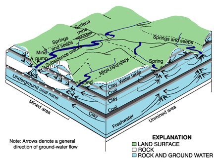 |
| Figure 5. Coal mines disrupt existing flow patterns of ground water and surface water. Oxygen dissolved in surface water is transported to rock strata containing pyrite. Sulfuric acid is produced, which may then emerge in springs, seeps, and streams carrying large amounts of dissolved metals. (Figure adapted from Puente and Atkins, 1989.) |
Surface and underground coal mining and coal-cleaning processes expose many elements to weathering. Pyrite and marcasite (iron disulfides also known as fools gold) are naturally occurring compounds commonly found in coal and in overburden rock. Pyrite is the major source of acid mine drainage (AMD) in the Eastern United States (Rose and Cravotta, 1998). During or after mining, AMD can be formed by a series of complex geochemical and bacterial reactions that occur when pyrite is exposed to air and water (Pennsylvania Department of Environmental Protection, 1999) (fig. 5). Through these reactions, some dissolved ferrous iron will precipitate out of solution in the form of insoluble ferric hydroxide (fig. 6).
 |
|
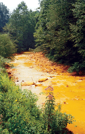
| Figure 6. Reddish-orange iron precipitate is commonly seen in streams affected by acid mine drainage. |
Secondary reactions of the acidic water can bring into solution other constituents in the coal and the overburden rock, such as manganese, aluminum, zinc, arsenic, bar um, cadmium, cobalt, copper, and silver. Some reach concentrations potentially dangerous to wildlife and may exceed drinking-water standards (table 1). These constituents are then subject to additional reactions (such as the formation of precipitates), are adsorbed onto sediments, or are taken up in the tissues of organisms (bioconcentrated).
Nearly all basins greater than 100 square miles within the coal-bearing region of ALMN have been mined at one time or another, many with several coal-extraction techniques. ium, cadmium, cobalt, copper, and silver. Some reach concentrations potentially dangerous to wildlife and may exceed drinking-water standards (table 1). These constituents are then subject to additional reactions (such as the formation of precipitates), are adsorbed onto sediments, or are taken up in the tissues of organisms (bioconcentrated).
| Nearly all basins greater than 100 square miles within the coal-bearing region of ALMN have been mined at one time or another, many with several coal-extraction techniques. |
Sulfate is an Indicator of Coal-Mining Activity
Coal-mine drainage can be acidic or alkaline and can seriously degrade both surface- and ground-water supplies. AMD, in which the acidity exceeds alkalinity, typically contains elevated concentrations of sulfate, iron, manganese, aluminum, and other dissolved material. In contrast, neutralized or alkaline mine drainage (NAMD) has an alkalinity that exceeds acidity; however, NAMD can still have elevated concentrations of sulfate, iron, manganese, and other constituents.
Dissolved trace elements are not generally reliable indicators of AMD or NAMD because they may not remain in solution. Sulfate, however, is a reliable indicator of mine drainage because sulfate is highly soluble and chemically stable at the pH levels normally found in natural waters (Hem, 1985).
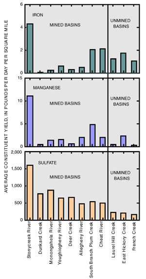 |
| Figure 7. Sulfate is a more stable indicator of mine activity than dissolved iron or manganese. |
The U.S. Environmental Protection Agency (USEPA) has established a Secondary Maximum Contaminant Level (SMCL) of 250 mg/L (milligrams per liter) for sulfate. SMCLs are applied to public water supplies and are nonenforceable levels for contaminants that may affect the taste, odor, or appearance of water. High sulfate concentrations in water may cause diarrhea in sensitive populations (U.S. Environmental Protection Agency, 1999a).
The amount of a constituent carried out of a stream system is called the yield. Sulfate yields were, on average, 5 times greater in stream basins where mining has occurred than in unmined basins sampled monthly in 199798 (fig. 7). With one exception (Stonycreek River), yields of dissolved iron and dissolved manganese were similar in mined and unmined basins.
The Stonycreek River had the highest sulfate yield of the 11 sampled streams and is considered to be highly degraded by AMD, primarily from abandoned mines. Currently, efforts are being made to restore the water quality in this river, mainly through the construction of passive treatment systems to treat abandoned-mine discharges inventoried in 199295 (Williams and others, 1996). Since 1995, about $3.5 million has been spent on mine-drainage remediation projects throughout the Stonycreek River Basin, resulting in the removal of iron, aluminum, and acidity from the Stonycreek River at a rate of 111, 133, and 1,192 tons per year, respectively (D. Seibert, Natural Resources Conservation Service, oral commun., 2000). A similar study to identify mine discharges was completed in a Monongahela River tributary, the Cheat River (Williams and others, 1999).
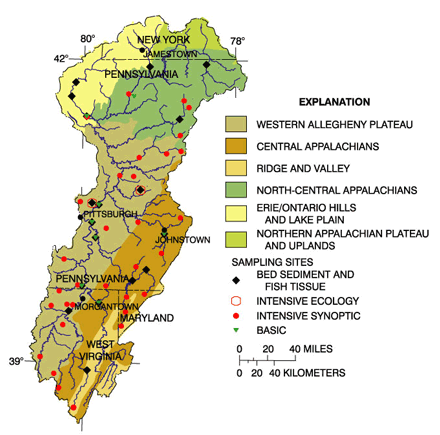 |
| Figure 8. Assessments of the health and condition of aquatic life and habitat focused on four of the six ecoregions represented on this map. Contaminants associated with bed sediment and tissue were analyzed at 19 sites. (Ecoregions from Omernick, 1987). |
Aquatic Communities are Affected in Streams Receiving Large Amounts of Mine Drainage
Streams receiving mine drainage may range from supporting diverse communities of aquatic life to being lethal to many organisms, depending on a variety of factors. The ecological setting of a stream can affect the types and rates of water-quality changes in response to human influences. Ecoregions and basin size are two factors that relate to differences in aquatic communities. Ecoregions are used to group areas that are ecologically similar and can be expected to have similar aquatic communities. ALMN is divided into six eco-regions (fig. 8), five of which were included in the sampling design in ALMN. Basin size affects species diversity because larger basins tend to have a greater variety of habitats available.
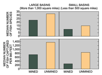
The fish community was sampled at 11 sites in ALMN, 7 of which received mine drainage. A difference in fish abundance and number of fish species was evident between streams in mined basins compared to those in unmined basins. None of the streams sampled had a depressed pH (less than 6.5). In the Central Appalachian Ecoregion, at Stonycreek River, only 2 species (2 individuals) were captured, whereas in Laurel Hill Creek, a similar stream in a nearby unmined area, 16 species (384 individuals) were captured. Where basin sizes were comparable, the presence or absence of coal mining in a basin was evident in some aspects of the fish-community structure (fig. 9).
 |
|
| Figure 9. The number of fish species and the number of individual fish captured per 985-feet stream reach was greater at unmined sites than at mined sites of comparable size. |
Few organisms can tolerate even brief periods of acidic or mineral- or silt-laden water. Episodic events or chronic conditions that result in concentrated AMD entering a stream are obvious and result in a nearly complete loss of aquatic species, such as in Stonycreek River. The effects are often more subtle in streams receiving NAMD, where species sensitive to sedimentation, trace-element concentration, or hydrologic changes are affected (Letterman and Mitsch, 1978). In a regional study between ALMN and the KanawhaNew River Basin, 61 sites were sampled for aquatic invertebrates (insects, worms, crustaceans, and mollusks) and water chemistry during a low-flow period in 1998. At sites where sulfate concentrations were greater than the estimated background level, decreasing diversity was noted for three groups of sensitive insect species (mayflies, stoneflies, and caddisflies), although pH was 6.5 or greater at all these sites. (See fig. 23 on page 21.)
|
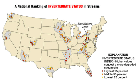
Aquatic life in stream systems where human influence is minimal generally represents a more natural community than in streams strongly influenced by human activity. These sites can be used to define background (reference) conditions that are helpful in interpreting how various land uses change the types and numbers of organisms living downstream. NAWQA examines fish, invertebrate, and algal communities and uses indices based on reference sites as part of assessing water quality. For example, an invertebrate status index (T.F. Cuffney, U.S. Geological Survey, written commun., 2000) averaged 11 invertebrate-community measures (metrics) used to indicate various aspects of the life cycles of the organisms assessed. This index can be used to make relative comparisons between sites sampled by NAWQA. An ALMN site, East Hickory Creek near Queen, Pa., whose basin is more than 95-percent forested, had the best quality (lowest invertebrate index score) nationally of 140 sites sampled between 1996 and 1998 (Appendix). In contrast, streams in either urban or coal-mine settings ranked among the highest 25 percent of those sampled.
|

Ground-Water Quality is Affected Near Mined Areas
During 199698, 45 domestic water-supply wells were sampled in ALMN in the high-sulfur coal region of the Appalachian coal fields (Tully, 1996). Water samples were collected from 30 of the 45 wells within about 2,000 feet and hydrologically downgradient (downhill in this area) from a reclaimed surface coal mine. The additional 15 wells are in areas believed to be unmined.
Analysis of ground-water data indicates that surface coal mining continues to affect ground-water quality after all mining and reclamation has ceased. Several constituents related to mine drainage exceeded the USEPA SMCL more frequently in water sampled from wells downgradient from reclaimed surface coal mines than in well water from unmined areas.
Sulfate concentrations exceeded the USEPA SMCL for sulfate (250 mg/L) at 20 percent of domestic wells sampled in mined areas but at no wells sampled in unmined areas. Iron concentrations at wells near mined areas exceeded the SMCL (300 µg/L [micrograms per liter]) in 60 percent of the wells, compared to 20 percent of wells in unmined areas. Similarly, manganese concentrations exceeded the SMCL (50 µg/L) in 70 percent of wells from mined areas compared to 47 percent of wells in unmined areas. Finally, samples from 20 percent of the wells in mined areas exceeded the SMCL for total dissolved solids, whereas samples from only 7 percent of the wells in unmined areas exceeded the SMCL.
Concentrations of mine-related constituents, such as sulfate, iron, manganese, and dissolved solids can exceed SMCLs for drinking water in unmined areas because of the geologic setting (mostly rocks of Pennsylvanian age that can contain high concentrations of iron and manganese). High concentrations of sulfate in ground water of the Appalachian coal fields, however, usually indicates that coal has been mined nearby or in a location hydrologically upgradient from the sample location. Current regulations do not require treatment of mine-discharge water for sulfate. Discharge water is generally regulated and treated to reduce concentrations of iron and manganese and to maintain pH in the range of 6.5 to 8.5 units.
Concentrations of Trace Elements in Bed Sediment Exceed Aquatic-Life Guidelines
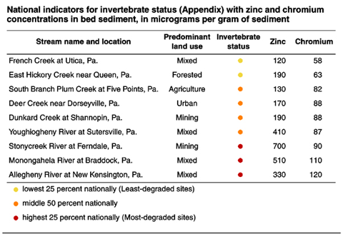
Trace elements typically are present in surface-water systems in small amounts. Local geologic conditions or land-use activities can increase the concentration of some elements to levels that may impair aquatic life or limit water use. Trace elements may be dissolved in water, bound to sediments, or incorporated into the tissues of organisms, depending on the chemical properties of each element. In ALMN, several trace elements in addition to zinc and chromium were detected at high concentrations in bed sediment or tissues (Appendix).
Arsenic is a trace element that is potentially damaging to both human health and aquatic life. Increased arsenic concentrations can result from human activity, such as application of pesticides or the combustion of fossil fuel, or from natural weathering of arsenicbearing rock (Ferguson and Gavis, 1972). Arsenic was detected at concentrations above the estimated background concentration of 5.9 µg/g (micrograms per gram) (Canadian Council of Ministers of the Environment, 1995) at all 50 bed-sediment sites sampled between 1996 and 1998 in ALMN. The Probable Effect Level (PEL) for arsenic in bed sediment of 17 µg/g (Canadian Council of Ministers of the Environment, 1995) was exceeded at 12 of 50 sites, where concentrations ranged from 18 to 52 µg/g.
Land use did not appear to be a factor in the arsenic concentrations observed in ALMN, although atmospheric deposition cannot be ruled out. Each of the sites in ALMN where the PEL was exceeded, with the exception of Stonycreek River (a heavily mined basin), were distributed in the northern, once glaciated part of the Allegheny River Basin. Glacial action during the last ice age broke up and moved near-surface rock, exposing this rock to weathering and releasing some arsenic (Welch and others, 1988).
In contrast, concentrations of some other trace elements in ALMN appear to be related to land use. Concentrations of cadmium, copper, chromium, lead, mercury, and zinc each exceeded the PEL aquatic-life guidelines in bed-sediment samples at least once in samples from mined or mixed-land-use sites.
Concentrations of cadmium in whole-fish samples, for which no guidelines exist, are among the highest sampled by NAWQA during 199598. Several trace elements (such as nickel) that also have no established guidelines for either bed sediment or tissue are elevated in mixed-land-use settings (Appendix).
|
The acidity of some mine drainage may dissolve and subsequently transport large amounts of trace elements from exposed rock. These trace elements, often found naturally in small amounts, can accumulate in streambed sediments. Trace elements, low levels of which are required by organisms, can reach toxic concentrations when concentrated in food, water, or sediments. Aquatic-life guidelines, used as a reference level, are based on Environment Canadas guideline (Canadian Council of Ministers of the Environment, 1995) and have no regulatory force in the United States. Zinc and chromium were found at all bed-sediment sampling sites in ALMN, and at the 50 sites sampled, the aquatic-life Probable Effects Level (PEL) for zinc (315 mg/g) and chromium (90.0 mg/g) was exceeded at 15 and at 5 sites, respectively (Appendix). Eleven bed-sediment samples from ALMN had zinc concentrations among the highest 10 percent nationally of samples analyzed by NAWQA since 1991. PELs were most often exceeded in areas subjected to industrial or mining land use in ALMN. Zinc, along with other trace elements that exceed aquatic-life guidelines, may contribute to degradation of aquatic communities in streams. Some sites in ALMN were among the most degraded sites nationally for aquatic invertebrates (Appendix).
|

Water Quality of the Large Rivers of the Allegheny and Monongahela River Basins is Improving
The large rivers sampled in ALMN are important for their environmental and esthetic qualities, as well as sources for drinking water. Sections of the upper Allegheny River are designated federally as Scenic Rivers (Pennsylvania Department of Conservation and Natural Resources, 2000). French Creek, a tributary of the Allegheny River, supports several State and federally protected endangered species (see page 12) and is an important stream nationally for the protection of aquatic species (Masters and others, 1998). Whitewater rafting on the Youghiogheny and Cheat Rivers is a thriving recreational industry.
The water quality in a river that drains large areas integrates water potentially influenced by a broad range of natural and human factors. The industrial and resource extraction land-use history in ALMN previously resulted in poor water quality in some rivers and streams. Early in the 1900s, fish were rarely found in the lower Allegheny and Monongahela Rivers and then only during high flows, when river water was diluted by surface runoff. Crayfish also were rare, and freshwater mussels had been eliminated (Ortmann, 1909). Ortmann described lower reaches of Monongahela River tributaries, the Cheat River and Youghiogheny River, as degraded by mine drainage. As recently as the mid-1960s, fish surveys on the Monongahela River found zero to four fish species (U.S. Army Corps of Engineers, 1976).
The Allegheny River and Monongahela River sites sampled in this study have been sampled comparably under various USGS programs since the early 1970s, permitting a general comparison of water-quality conditions since that time.
A measure of the acidic and basic properties of natural waters is pH. The pH of source water is useful for determining water-treatment options and evaluating the suitability for support of aquatic plants and animals. Natural factors, such as rock types in a basin, can affect pH, as can industrial discharges and mine drainage. As recently as the 1960s, the Monongahela River was occasionally too acidic (low pH) to support a diverse aquatic community (Finni, 1988). Since the early 1970s, the median pH at the NAWQA sampling sites increased from 7.0 in the period 1975 to 1987 to 7.4 in the period 1987 to 1998 in the Allegheny River. During the same periods, the median pH increased from 7.0 to 7.6 in the Monongahela River. Although this represents an overall increase in pH for both sites, about 1 percent of the samples collected from these two sites had pH values that were lower than the minimum aquatic-life water-quality guideline of 6.0 (Pennsylvania Department of Environmental Resources, 1984) during the period 1987 through 1998. For organisms living in these rivers, occasional periods when the pH is either too high or too low can be lethal for a particular species.
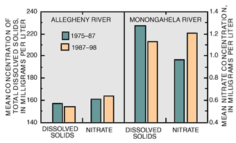 |
| Figure 10. For the two 12-year periods examined, the Allegheny and Monongahela Rivers improved in some water-quality respects (MCL, Maximum Contaminant Level; SMCL, Secondary Maximum Contaminant Level). |
The concentration of dissolved solids in a water body can be increased as a result of industrial or municipal wastes, drainage from mines or oil fields, or drainage from agricultural land. Median concentrations of dissolved solids have decreased at the Allegheny and Monongahela River sampling sites over the last 25 years. Dissolved-solids concentrations have decreased by 2 percent in the Allegheny River and by 6 percent in the Monongahela River. Reductions in dissolved solids in the Monongahela River have virtually eliminated the exceedences of the SMCL of 500 mg/L (fig. 10).
Elevated nitrate concentrations can result in increased plant and algal growth (U.S. Geological Survey, 1999a), which can, in turn, alter the taste of water and affect other aquatic life. Nitrate increases can be related to some of the same sources as dissolved solids, including both point-source discharges, such as industrial wastewater discharges and sewage, or nonpoint sources, including atmospheric deposition and agricultural fertilizer use (U.S. Geological Survey, 1999a). In contrast to dissolved solids, however, median nitrate concentrations have increased by 3 percent in the Allegheny River and by 25 percent in the Monongahela River. Nitrate, which contains nitrogen, can be converted to other nitrogen-containing compounds relatively easily. Total nitrogen was not routinely measured in early studies. The increase observed in nitrate may be partly the result of changes in the form of nitrogen in the rivers, typically due to sewage-treatment-plant upgrades (U.S. Geological Survey, 1999a).
The general improvement in water quality described above in sections of the Allegheny and Monongahela Rivers has been accompanied by an increase in the number and species diversity of fishes. A sample of the fish community at the Monongahela River site in 1998 contained more than 1,100 individual fish representing 12 species. This included many sport fish such as smallmouth bass and sauger. Species richness was even greater in the Allegheny River, which had 21 species, again including many sport fish as well as species sensitive to pollution, such as redhorse sucker. Significantly, the silver chub, Macrhybopsis storeriana, a minnow that had not been seen in these rivers since the late 1800s (Cooper, 1983), was captured in both 1997 and 1998. The recovery of rare species is a further indication of the degree of improvement in water quality in these river segments.
Persistent Pesticides and PCBs were More Prevalent in Fish Tissue than in Sediment
Numerous synthetic organic compounds have been manufactured to fulfill various needs of society. These compounds have a range of stability in the environment. Some break down rapidly, whereas others can be highly stable and persistent. Some stable synthetic organic compounds are no longer in use in the United States.
Organochlorines in this group are commonly soluble in fat or can bond to particles in the water and settle out. Some bioconcentrate in fat, reaching higher concentrations in organisms than in the environment. They can accumulate in predators that eat contaminated organisms. In the tissues of animals, these compounds can have a variety of effects including toxicity, reproductive impairment, or cancer. Whole fish from 16 sites in ALMN were analyzed for 28 organochlorine compounds. Streambed sediment was analyzed for 32 compounds at these same 16 sites plus an additional 3 sites (fig. 8). At the sites where both fish and bed sediment were sampled, those compounds detected in both media were present at higher concentrations in fish tissue than in the sediment (Appendix).
Although use of PCBs was discontinued in the United States in the 1970s, PCBs were detected in whole-fish tissue samples at 10 of 16 sites in 1997. This mixture of compounds was detected at only 4 of 19 sites in streambed sediment. Those sites at which PCBs were below the detection level in fish tissue were in basins dominated by agriculture or forest. Fish-tissue samples from eight sites with mixed land use had total PCB concentrations above the guideline for protection of fish-eating wildlife (Newell and others, 1987).
DDT and chlordane use has been discontinued in the United States since the 1970s. DDT and its breakdown products were dectected in fish at 15 of 16 sites and in sediment at 9 of 19 sites. Only at the Allegheny River at New Kensington, Pa., however, did the concentration of total DDT in fish samples exceed the guideline of 200 mg/kg (micrograms per kilogram) established to protect fish-eating wildlfe. Chlordance was detected in 11 to 16 whole-fish samples and in 4 of 19 streambed-sediment samples. The guideline of 500 mg/kg for total chlordane (which also includes breakdown products) for protection of fish-eating wildlife was exceeded in fish samples only at the Monongahela River near Braddock, Pa.
Public-health advisories are in place to restrict consuption
or prohibit taking of several fish species from certain sections of the
Allegheny and Monongahela Rivers because of PCB and chlordane contamination
(Pennsylvania Fish and Boat Commission, 1999). These compounds are relatively
stable, are apparently being cycled between aquatic life and bed sediment,
and may persist in ALMN for many more years.

Low Concentrations of Numerous Pesticides were Detected in an Agricultural Stream and an Urban Stream
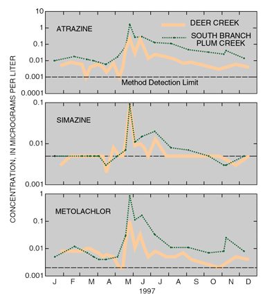
Two basins of similar size were chosen to assess the occurrence and distribution of a broad range of pesticides under different streamflow conditions. The Deer Creek Basin represented a predominantly residential/urban setting, and the South Branch Plum Creek Basin represented a predominantly agricultural setting (Williams and Clark, 2001).
 |
|
| Figure 11. A distinct seasonal pattern is evident in the concentrations of atrazine, simazine, and metolachlor. The peak concentrations of these three pesticides coincide with herbicide-application periods and increased spring rainfall. (Concentrations below the method detection limit are believed to be reliable detections but with greater than average uncertainty in quantification.) |
Of the 84 pesticides and pesticide metabolites (breakdown products) in this analysis, 25 were detected at least once in Deer Creek and 20 were detected at least once in South Branch Plum Creek. Some pesticides show a seasonal pattern in water samples from both streams (fig. 11).
All detectable pesticide concentrations from both streams were less than drinking-water-quality guidelines or standards (table 2). However, the maximum measured concentrations of diazinon in Deer Creek (0.097 µg/L) and South Branch Plum Creek (0.094 µg/L) exceeded the water-quality guideline to protect aquatic life of 0.08 µg/L.
Prometon is the most commonly detected herbicide in surface water and ground water in urban areas (Capel and others, 1999). It is used as a preemergent herbicide to control vegetation on bare ground around buildings and fences, along rights-of-way, and in conjunction with the application of asphalt. Prometon was detected in 90 percent of the samples collected in Deer Creek. The highest measured concentration was 0.355 µg/L in the first of five storm samples collected on August 2526, 1998. That concentration was more than 10 times the maximum measured concentration in 1997 but is still well below the drinking-water-quality guideline of 100 µg/L. No prometon guidelines have been established for the protection of aquatic life.
The insecticide diazinon is commonly used in homes, gardens, parks, and commercial areas. Detections of diazinon from samples collected in Deer Creek in 1997 showed no seasonal pattern; however, five of the seven detections were in samples collected shortly after a peak in streamflow due to overland runoff.
The aquatic-life water-quality guideline for carbaryl of 0.2 µg/L was exceeded in four of the five stormflow samples collected in Deer Creek on August 2526, 1998.
| Table 2.
Many pesticides are in widespread use for the control of
insects (insecticides) or plants (herbicides). Pesticides may be sold
under a variety of names, depending on the manufacturer (Table adapted
from U.S. Geological Survey, 1999b) [µg/L, micrograms per liter; NA, not available] |
||||
| Pesticide name |
Trade name |
Use |
Drinking-water-quality guidelines or standards |
Aquatic-life water-quality guideline |
|---|---|---|---|---|
| Atrazine |
AAtrex, Atrex, Atred, Gesaprim |
Herbicide |
31 | 1.8 |
| Diazinon |
Basudin, Diazatol, Neocidol, Knox Out |
Insecticide |
.6 | .08 |
| Dieldrin |
Panoram D-31, Octalox, Compound 497, Aldrin epoxide |
Insecticide |
.02 | .056 |
| Carbaryl |
Carbamine, Denapon, Sevin |
Insecticide |
700 | .2 |
| Metolachlor |
Dual, Pennant |
Herbicide |
70 | 7.8 |
| Prometon |
Pramitol, Princep, Gesagram 50, Ontracic 80 |
Herbicide |
100 | NA |
| Simazine |
Princep, Caliber 90, Gesatop, Simazat |
Herbicide |
41 | 10 |
| 1 Drinking water-quality standard (Maximum contaminant level). | ||||
A note on National biological status scores Although water-quality guidelines for the protection of aquatic life were exceeded for several of the pesticides detected in ALMN, there is no indication that the concentrations have been lethal to the organisms in these streams. National invertebrate and algal scores indicate that these biological communities have not been degraded and are comparable to those at a forested site in ALMN (Appendix). The national fish status score, although indicating that the urban and agricultural setting have better quality fish communities than the forested site, places considerable emphasis on non-native fish species. The forested site is stocked with non-native trout to supplement sport fishing. Abundant non-native fish populations are an indicator of human influence and may point to habitat or water-quality degradation in other situations. |
| Table of Contents || Previous Section || Next Section || Glossary U.S. Geological Survey Circular 1202 Suggested citation:
|
