
SUMMARY OF MAJOR FINDINGS
|
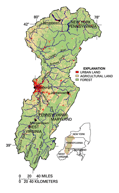
| The Allegheny and Monongahela River Basins drain 19,145 square miles of Pennsylvania, West Virginia, New York, and Maryland. About 64 percent of the study area is forested; the remainder is a patchwork of land uses. Agriculture (30 percent) is commonly low intensity pasture, dairy, and hay. Urban areas account for about 4 percent of the area, but they include many forested ridges. Coal-mining activities influence water quality in most of the study area but are not visible on this surface land-use map. (Land-use coverage is based on 1991, 1992, and 1993 land-use data.) |
Streams and rivers in the Allegheny and Monongahela River Basins range from those of high quality that support diverse aquatic life to those that are seriously degraded and support few aquatic species and few human uses of the water. Higher quality stream reaches are generally in the northern one-third of the study area and in mountainous areas in eastern sections. These areas are dominated by forest, low-intensity agriculture, and rural communities. Urban development and coal-mining activities through much of the basins have had a significant influence on water quality and aquatic life. Industrial activity in small and large towns has resulted in contaminated streambed sediments and contaminated fish. Acid- and(or) mineral-laden mine drainage from abandoned coal mines is one of the most serious and persistent water-quality problems in the basins, limiting water use and aquatic resources. Sulfate concentrations were 5 times greater in streams draining mined areas than in streams draining unmined areas.
-
Sulfate concentration is closely related to coal production in the sampled basins but not as clearly related to pH or dissolved metal concentration. (See page 6.)
-
Since 1980, treatment of drainage from active and abandoned mines has generally resulted in improved water quality, with increased pH and lower metal and sulfate concentrations, but diversity and abundance of aquatic organisms remain reduced in comparison to unmined areas. (See pages 7, 20, and 21.)
 |
-
Zinc in bed sediment exceeded aquatic-life guidelines at 15 of 50 sites. (See page 9.)
-
Arsenic concentrations most often exceeded aquatic-life guidelines in bed sediment in streams draining northern, once glaciated areas, and high concentrations appear to be unrelated to human activity. (See page 10.)
-
Streams in forested settings are among the most diverse nationally with respect to aquatic insects among NAWQA sites sampled between 1996 and 1998. (See page 8.)
-
A group of now-banned industrial chemicals, polychlorinated biphenyls (PCBs), was detected in 43 percent of sediment and fish-tissue samples. Consumption advisories are in place for several fish species because of PCB and chlordane contamination in some large river reaches. (See pages 11 and 12.)
- Some of the most degraded stream reaches have, since the early 1900s, supported few aquatic organisms. Yet, the quality of many reaches is now improving, and abundant fish and invertebrate populations include sensitive species not seen here in decades. (See page 11.)
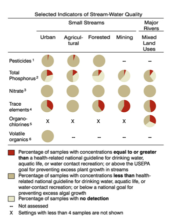
- In sampled streams in basins dominated by urban or
agricultural land, pesticides and volatile organic compounds (VOCs)
were commonly detected, although generally at concentrations meeting
drinking-water and aquatic-life standards and guidelines. (See pages
1213
and 1517.)
- Pesticide concentrations in stream water exceeded
drinking-water guidelines in single samples from each of two basins,
one dominated by agriculture and the other dominated by urban land use.
(See pages 12 and 13.)
| Major Influences on Streams and Rivers
|
Although not regulated, the quality of water from domestic wellsthe predominant water source for residents of rural areasmeets Federal standards for drinking water for most substances analyzed in this study. Ground-water supply generally meets or exceeds expectations from wells in the highly permeable glaciofluvial deposits of the valley-fill aquifers in the northwest. Ground-water supply often meets needs but can be meager from wells tapping the water-filled fractures of the fractured-rock aquifers present throughout much of the rest of the study area.
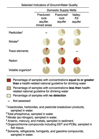 |
- Compared to ground water in unmined areas of the coal-bearing rocks, water in shallow private domestic wells near reclaimed surface coal mines had higher concentrations of sulfate, iron, and manganese, even after all mining and reclamation had been completed. (See pages 9 and 21.)
- Pesticides were detected more frequently in the valley-fill aquifers of the glacial sediments than in fractured-rock aquifers. (See pages 13-15.)
- Overall, VOCs were detected at very low levels in the 95 ground-water samples analyzed. Gasoline-related compounds were detected slightly more frequently and at slightly higher concentrations in ground water near reclaimed surface coal mines than near unmined areas. (See pages 16 and 17.)
- Nitrate was detected in 62 percent of sampled wells, although only one domestic-well sample exceeded the drinking-water standard for nitrate. (See pages 17 and 18.)
- Radon was detected at levels exceeding the proposed Federal drinking-water standard of 300 pCi/L (picocuries per liter) in 56 percent of the ground-water samples. The proposed alternative standard (4,000 pCi/L) was exceeded in 2 percent of the samples. (See page 19.)
| Major Influences on Ground Water
|
| Table of Contents || Previous Section || Next Section || Glossary U.S. Geological Survey Circular 1202 Suggested citation:
|
