
INTRODUCTION TO THE KANAWHANEW RIVER BASIN
Population and Human Activities
The Kanawha River and its major tributary, the New River, drain 12,223 mi² in North Carolina, Virginia, and West Virginia (Messinger and Hughes, 2000). Most of the total basin population of 870,000 (1990 data) live in rural areas, and industrial and residential areas cover less than 5 percent of the total area in the basin (fig. 1). Only about 30 percent of the population live in towns larger than 10,000 people, including the 25 percent who live in the Charleston, W. Va., metropolitan area. The total population has not changed substantially since the 1950s, mostly because of emigration from rural parts of the basin to urban centers in the Midwest and the South.
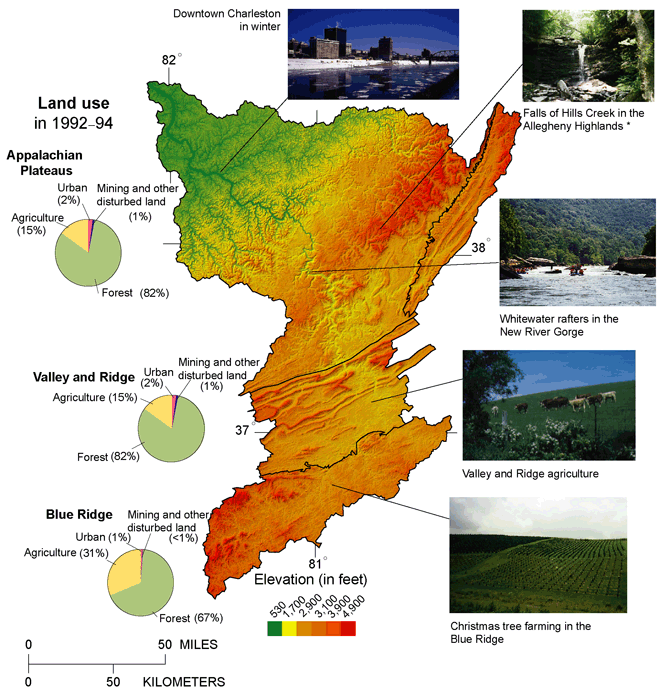 |
| Figure 1. In the mountainous Kanawha-New River Basin, elevation ranges from over 4,000 feet in the Allegheny Highlands of the Appalachian Plateaus Province and the Blue Ridge Province to about 560 feet at the mouth of the river at Point Pleasant,W. Va. Forest accounted for 81 percent of the land cover in 1993 (Multi-Resolution Land Characteristics Interagency Consortium, 1997). Logging is a major industry throughout the basin. The entire basin was logged by the early 20th century, and no undisturbed areas remain (Clarkson, 1964). Coal mining is prevalent in the Appalachian Plateaus. The Blue Ridge Province contains proportionally more agricultural land than the Appalachian Plateaus and Valley and Ridge Provinces. Cattle, hay, and corn grown as cattle feed are the primary agricultural products (National Agriculture Statistics Service, 1999). Physiographic provinces from Fenneman, 1938. *Photograph by Julie Archer, and used by permission. |
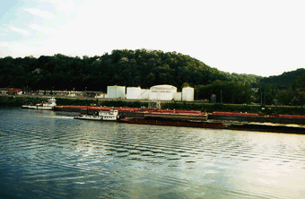 |
| Figure 2. Coal and motor fuel commonly are transported by barge on the Kanawha River, downstream from Kanawha Falls. |
The only major industrial area in the basin is along the terrace of the Kanawha River, within about 20 miles of Charleston (fig. 2). Chemical industry practices that profoundly polluted the Kanawha River during the 1950s and 1960s have changed, and discharge of pollutants to streams has greatly decreased, although bed sediment and fish remain contaminated with dioxin and other industrial chemicals (Henry, 1981; Kanetsky, 1988; West Virginia Division of Environmental Protection, 2000).
In the KanawhaNew River Basin, most coal is mined in the Appalachian Plateaus in West Virginia (McColloch, 1998). About 7 percent of the coal mined in the United States comes from the KanawhaNew River Basin (Fedorko and Blake, 1998; Messinger and Hughes, 2000). Most coal mined in the basin has a low sulfur content. Coal production has increased since passage of the Clean Air Act amendments of 1990, which mandated a reduction of sulfate emissions to decrease acid precipitation.
Physiography
The streams and rivers of the basin drain areas in three physiographic provinces: the Blue Ridge (17 percent), the Valley and Ridge (23 percent), and the Appalachian Plateaus (60 percent). In the Appalachian Plateaus, little of the land is flat, and most flat land is in the flood plains and terraces of streams. The Valley and Ridge is characterized by strongly folded ridges separated by relatively flat, broad valleys. These two regions are underlain by sedimentary rocks. The Blue Ridge is characterized by igneous and metamorphic rocks that have been folded and faulted.
Water Use
In 1995, 61 percent of the basins population depended on surface-water supplies for domestic needs (Solley and others, 1998). Thirty percent relied on domestic water wells. The remaining nine percent used public-supply water wells. In 1995, total withdrawal of water was about 1,130 Mgal/d (million gallons per day); total consumptive use was about 118 Mgal/d.
Hydrologic Conditions and Features
With some exceptions, mean streamflow during the study was within about 10 percent of long-term mean flows at most gaging stations (see records from a representative station in fig. 3). Major flooding occurred throughout the Appalachian Plateaus in January 1996, seven months before sampling began, and streamflow at several gaging stations within the KanawhaNew River Basin exceeded the 100-year flood flow (Ward and others, 1997). A thunderstorm in June 1998 caused flooding in the northwestern part of the basin where flow on a few small streams exceeded the 100-year recurrence interval (Ward and others, 1999). With the exception of these floods, no other flows exceeded the 10-year recurrence interval. No streams in the basin were in drought conditions during the study.
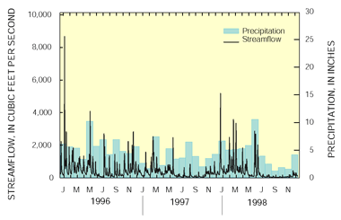 |
| Figure 3. After a major flood in January 1996, streamflow from Williams River at Dyer, W. Va., and precipitation from Richwood, W. Va., were normal throughout the study period. The long-term average annual streamflow at Williams River at Dyer, W. Va. is 336 cubic feet per second. Long-term average precipitation at the Richwood, W. Va. location is 48 inches per year. |
Streamflow varies most through the year in the western Appalachian Plateaus, and it varies least through the year in the Blue Ridge. On average, streamflow throughout the basin is greatest in February and March and least in September through October. Maximum streamflow does not coincide with maximum precipitation because summer vegetation uses a large fraction of the precipitation.
The river system in the KanawhaNew River Basin is regulated by four major flood-control dams, three navigation dams, and several smaller dams. The two largest dams are on the Gauley River (Summersville Dam) and Elk River (Sutton Dam). The other two major dams are on the New River. The navigable reach of the Kanawha River is in backwater caused by the navigation dams. In this reach, stream depth is greater and velocity is less than in the undammed reaches of the major rivers. All pools behind dams in the basin collect sediment. Dams are also major barriers to fish movement.
| Table of Contents || Previous Section || Next Section || Glossary U.S. Geological Survey Circular 1204 Suggested citation:
|
