
MAJOR FINDINGS
Persistent Changes in Water Chemistry and Aquatic Biology are Evident in Coal-Mined Areas
About 7 percent of all coal mined in the Nation comes from an area of 5,000 mi² in the Appalachian Plateaus part of the KanawhaNew River Basin. Production of the mostly low-sulfur coal nearly doubled from 1980 to 1998 as mining technology advanced, individual mines became larger, and employment decreased. Total production is about 90 million tons per year. A coal seam 1 foot thick and 1 mile square weighs about 1 million tons.
Most drainage basins within the coal region have been mined repeatedly as technology has advanced and economics have changed. Only three unmined basins greater than 10 mi² in the coal mining region were identified in this study. Among mined basins, cumulative coal production of less than 10,000 ton/mi² of coal during 198095 is low. Cumulative production in many basins ranged from 100,000 to 1,000,000 ton/mi².
Most water that drains from coal mines in the KanawhaNew River Basin is naturally neutral or alkaline rather than acidic.When iron pyrite in coal and adjacent rocks is exposed to air and water during mining, a series of chemical reactions produce dissolved iron and sulfuric acid (Rose and Cravotta, 1998). Natural or applied limestone, lye, or anhydrous ammonia can neutralize the acid (Skousen and others, 1998), but sulfate ions dissolved in water generally remain as evidence of the reactions. Sulfate concentrations in streams decrease slowly after mining ends (Sams and Beer, 2000).
Since 1981, Total Iron and Manganese have Decreased in Stream Basins where Coal Mining has Continued, but Sulfate has Increased
During low flow in July 1998, water samples from 57 wadeable streams (drainage area less than 1 to 128 mi²) were analyzed once. Samples were collected from streams in the region of the Appalachian Plateaus where coal has been mined. At least three analyses were available for 51 of the sites for 197981, before the Surface Mining Control and Reclamation Act (SMCRA) affected regional water quality (Ehlke and others, 1982). Each 1998 analysis was compared to the one earlier analysis with the closest corresponding streamflow. Results were interpreted with respect to cumulative mining history and other land uses in each basin.
|
||||||||||||||||||||||||||||||
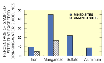
Median concentrations of total iron and total manganese were lower in 1998 than during 197981 in 33 basins that had been mined both before and after SMCRA, but sulfate concentration and specific conductance were higher (table 1). In 1998, median total manganese, specific conductance, sulfate, and pH were higher in 37 basins mined since 1980 than in 20 basins unmined since then; median total iron was lower in the mined basins, possibly reflecting aggressive treatment of permitted discharges.
 |
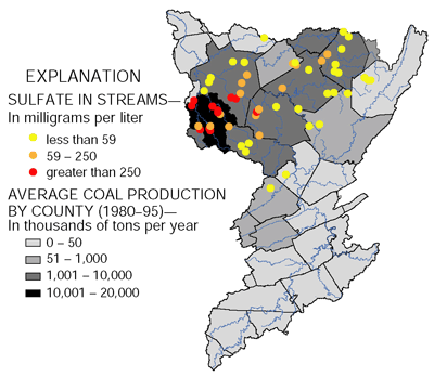
| Figure 4. Sites with a low concentration of sulfate drained basins with little recent coal production. Sites with a high concentration of sulfate drained basins with a wide range of recent coal production. |
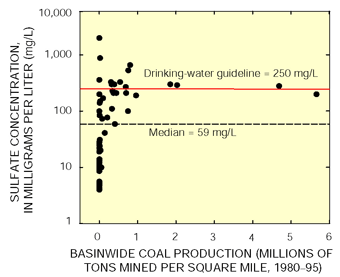
At the time the SMCRA and subsequent regulations were established, acidification and subsequent increase in metal concentrations, but not sulfate concentration, were known to degrade stream quality. Regulations, therefore, were targeted at decreasing mining-related acidification and concentrations of iron and manganese, but were not designed to decrease sulfate concentrations. Sulfate concentrations less than 59 mg/L (milligrams per liter; study median) were measured only from basins where less than 142,000 ton/mi² of coal were produced during 198095 (figs. 4 and 5). In contrast, manganese concentrations less than 32 µg/L (micrograms per liter; study median) were measured at several heavily mined basins (fig. 6).
 |
| Figure 5. Sulfate concentration in wadeable streams was highest in counties with the highest coal production. |
Sulfate concentration in streams draining mined areas does not correlate strongly with coal production because sulfate production depends on local geology, mining practice, and possibly results from activities in addition to mining. Sulfate concentration is higher than background, however, in basins with the greatest coal production. Background sulfate concentration was less than 25 mg/L in 16 of 20 basins not mined since 1980. In contrast, sulfate concentration was greater than 250 mg/L in 8 of 15 mined basins drained by streams tributary to the Coal River. The USEPA guideline for sulfate in drinking water is 250 mg/L.
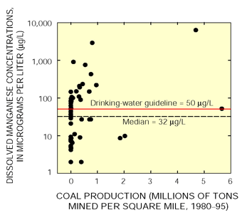 |
| Figure 6. Concentrations of manganese in about half of the streams draining heavily mined basins were less than the study median. |
For two years, water chemistry was analyzed monthly and at high flow at two streams in heavily mined basins, and at one stream where no coal had been mined since 1980. At the mined sites, sulfate, several other ions, and specific conductance decreased as streamflow increased; at the unmined site, major-ion concentrations were low at all flows (fig. 7). Dissolved iron and manganese concentrations were virtually unrelated to flow at all three sites. At both Peters Creek near Lockwood and Clear Fork at Whitesville, specific conductance was correlated with sulfate concentration, and correlations were nearly as strong between specific conductance and dissolved calcium, magnesium, sodium, and chloride. The same patterns were found in data for the sites before the implementation of the SMCRA.
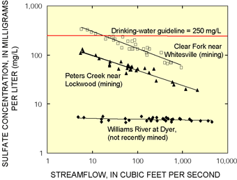 |
| Figure 7. The concentration of sulfate, like other major ions, decreased with flow at two heavily mined sites but was consistently low at a site with no recent mining (Clear Fork R2=0.90, Peters Cr R2=0.91, Williams River R2=0.11). |
Streamflow, water temperature, pH, and specific conductance were measured hourly at the two mined sites during the same two years. In the Coal River Basin at Clear Fork, sulfate concentration (estimated from the hourly specific conductance) exceeded the 250-mg/L guideline about 25 percent of the time. Sulfate concentrations across a range of flow at Clear Fork were at least 10 percent greater in 1998 than in 197981.
| Coal-mining methods in the KanawhaNew
River Basin |
Stream Benthic-Invertebrate Communities are Impaired at Mined Sites
In all streams sampled that drain areas where large quantities of coal have been mined, the benthic-invertebrate community is impaired in comparison to rural parts of the study area where little or no coal has been mined since 1980 (fig. 8). Some streams in which the community is impaired drained areas that were not heavily mined.
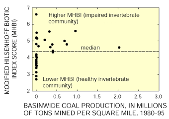 |
| Figure 8. Only sites with little recent coal production had healthy invertebrate communities as measured by low (favorable) scores on the Modified Hilsenhoff Biotic Index, although not all impared sites were in areas of high coal production. |
Invertebrate communities were sampled from riffles at 29 wadeable streams in areas of the Appalachian Plateaus where coal is or has been mined (Chambers and Messinger, 2001). The sites were separated into two groups by statistical comparison of species composition and abundance. Each group contained communities that were similar. The communities that included several insect taxa known for intolerance of fine sediment were identified as the less impaired group of sites. These taxa include Epeorus mayflies and Dolophilodes and Rhyacophila caddisflies (fig. 9). Epeorus is a genus of relatively large mayflies that cling to the bottom of large, loosely embedded rocks. Fine sediment can fill the openings in the stream bottom where they live. Caddisflies in the genus Dolophilodes spin finely meshed nets that can be clogged with silt. Rhyacophila are mobile predators typically found in clean, cool-water streams. These intolerant taxa were not present in the invertebrate communities at sites identified as poorer. In addition, scores from the MHBI (Modified Hilsenhoff Biotic Index; see glossary) and proportions of pollution-tolerant taxa from the midge family were significantly greater at the more impaired group of sites. The MHBI and other biological metrics are mathematical summaries of characteristics that change predictably in response to environmental stress. They are used to measure ecological health of a system (Karr and Chu, 1999).
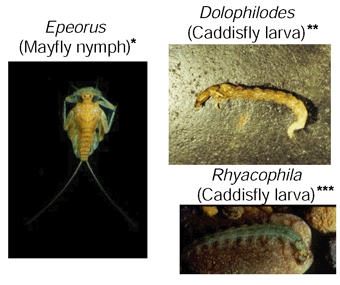 |
| Figure 9. Invertebrates that are intolerant of fine sediment were present at unmined sites and sites with little coal production since 1980. (Photograph by * Jennifer Hiebert, University of Alberta; ** D.B. Chambers, USGS; *** Arturo Elosegi, North American Benthological Society. All photos reproduced with permission) |
| Benthic invertebrates are good indicators
of overall stream-water quality |
Differences in land use, stream habitat, and stream chemistry between the groups of sites suggest possible causes for the different invertebrate communities. The less impaired group of sites drained basins that were unmined, or where less than 10,000 ton/mi² were mined during 198095. Most basins in the more impaired group of sites had been mined within the last 20 years by both surface and underground methods; most contained abandoned mines that pre-dated SMCRA and produced 100,000 to 1,000,000 ton/mi² of coal. Some of the basins in the more impaired group, however, had not been mined since 1980. Coal production during 198095 is not an ideal indicator of the environmental disturbance caused by coal mining, but it related better to environmental measurements than did production over a shorter interval, number of abandoned mines, or mine discharge permits (Chambers and Messinger, 2001).
At the more impaired sites, the proportion of total land area as strip mines, quarries, disturbed land, or gravel pits was significantly greater than at the less impaired sites. In addition, sulfate concentration, specific conductance, and alkalinity of stream water were all higher. Stream pH did not differ significantly between the two groups; pH is regulated in mine discharges.
Two basins that were not mined since 1980 contained valley fills similar to those constructed at large surface mines. The invertebrate community in Mill Creek near Hopewell, W. Va., which drains an area with few relatively small fills, grouped with the less impaired sites. Davis Creek at Trace Creek, W. Va., drains several large fills at a shopping center and was in the poorer group.
Instream habitat structure also differed significantly between the two groups. Sites from the less impaired group had less sand and silt in the stream bottom. Smaller median sediment size correlated with decreased number of taxa of mayflies, stoneflies, and caddisflies (EPT taxa) and an increased (more impaired) score on the Modified Hilsenhoff Biotic Index (fig. 10; r² = 0.46 and 0.43, respectively). Among the sites sampled, correlations between invertebrate metrics and coal production (or factors relating to coal mining) were weak, largely because some streams were impaired by other land uses. Erosion and sediment deposition in basins with active mines have decreased overall because of controls required under SMCRA, but temporal comparisons are not possible. Sedimentation in 1998 remained generally greater, however, at sites in basins with coal production since 1980 than in unmined basins.
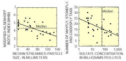 |
| Figure 10. Invertebrate-community metrics show generally better conditions (lower MHBI) at sites with coarser streambeds and lower sulfate concentrations, although correlations are weak. |
The invertebrate-community degradation represented the cumulative effects of mining before and after SMCRA, deep mining and surface mining, mines in and out of compliance with applicable regulations, and all other nonmining disturbances in the basins. Impaired sites from this region ranked near the middle of an index that ranked NAWQA sites representing different land uses throughout the United States. (See discussion of effects on invertebrate communities nationally, p. 11). Logging and ongoing construction probably contribute to sedimentation, but their extent in each basin could not be quantified. Logging may contribute more sediment per disturbed volume of soil than mining.
| Regional study: Sulfate concentrations and biological communities in Appalachian coal fields indicated mining-related disturbances despite a general water-quality improvement between 1980 and 1998 |
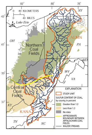 |
| Figure 11. Coal seams in the Appalachian coal region vary in sulfur content, and the fields are identified primarily on the basis of theis difference (Tully, 1996). The Kanawha–New River Basin contains mostly lower sulfur coal, while the Allegheny and Monongahela River Basins contain mostly higher sulfur coal. |
In a 1998 study to assess regional water-quality effects of coal mining (Eychaner, 1999), samples representing the Northern Appalachian coal field were collected in the Allegheny and Monongahela River Basins (ALMN), where high-sulfur coal is common and acid mine drainage was historically severe, and samples for the Central Appalachian coal field were collected in the KanawhaNew River Basin (KANA), where acid drainage is uncommon (fig. 11).
Water chemistry in 178 wadeable streams was analyzed once during low flow, in July and August 1998. Drainage area for most streams was between 4 and 80 mi². Most (170) of these sites were also part of a study on the effects of coal mining that was conducted during 197981 (Herb and others, 1981a, 1981b; 1983; Ehlke and others, 1982), before regional water quality was affected by implementation of regulations from the Surface Mining Control and Reclamation Act (SMCRA). At 61 sites, aquatic invertebrates (insects, worms, crustaceans, and mollusks) also were collected. Ground water was sampled from 58 wells near coal surface mines and 25 wells in unmined areas. Wells sampled downgradient from reclaimed surface coal mines reflect the local effects of mining.
Concentrations of Regulated Constituents Improved in Stream Base Flow From About 1980 to 1998
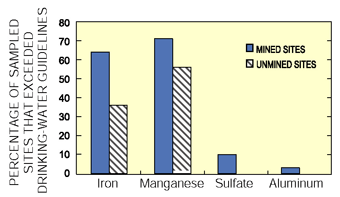
During low-flow conditions, sulfate in more than 70 percent of samples from streams downstream from coal mines in both coal regions exceeded the regional background concentration. Background was calculated as about 21 mg/L sulfate from data for basins with no history of coal mining. The highest concentrations were measured in basins with the greatest coal production. One-fourth of all samples exceeded 250 mg/L, the USEPA drinking-water guideline.
Total iron, total manganese, and total aluminum also exceeded regional background concentrations (129, 81, and 23 µg/L, respectively) in many streams in mined basins. The median concentrations of total iron in the northern coal region were about equal between mined and unmined basins, but in the central region, concentrations of median total iron among mined basins were lower than among unmined basins. In both regions, median concentrations of total manganese among mined basins were about double that among unmined basins.
 |
| Figure 12. Stream water more often exceeded drinking-water guidelines at mined sites that at unmined sites. |
Median pH increased, and median concentrations of total iron and total manganese decreased among mined basins between 197981 and 1998 in both regions, reflecting that regulations restricting these constituents in mine drainage are effective. Even so, stream sites downstream from mines more commonly exceeded drinking-water guidelines for sulfate, iron, manganese, and aluminum concentrations than streams in unmined basins (fig. 12).
Aquatic Benthic Invertebrate Communities are Impaired in Mined Basins
Aquatic invertebrate communities tended to be more impaired where there was more coal mining, when compared to basins where there was little coal mining. Pollution-tolerant species are more likely to be present at mined sites than at unmined sites, whereas pollution-sensitive taxa were fewer in number or non existent in heavily mined basins. Increasing coal production correlated with both an increased concentration of sulfate and a decline in some aquatic insect populations (fig. 13). Of the 61 sites where aquatic invertebrates were collected, those sites with sulfate concentrations higher than the estimated background concentration had the lower diversity of three groups of sensitive insect species (mayflies, stoneflies, and caddisflies), even though the pH of the water at all sites was greater than 6.5.
|
|
| Figure 13. Sulfate concentration in stream water was inversely related to the number of mayfly, stonefly, and caddisfly taxa found at water-quality sampling sites. |
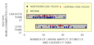
At the concentrations measured, the sulfate ion is relatively non toxic to aquatic organisms and may not represent the cause of the decline observed in mayflies and stoneflies. Sulfate concentration was, however, positively correlated with the total coal production from a basin (Sams and Beer, 2000). Other landscape disturbances associated with coal miningchanges in streamflow, siltation, or trace metal contaminationcould affect the invertebrate community. Negative effects on communities caused by mining were of similar magnitude to the effects of urban development, agriculture, large construction projects, flow alterations, or wastewater effluent.
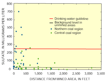 |
| Figure 14. Sulfate concentrations in ground water are greater within 1,000 feet of reclaimed surface coal mines and in the northern coal region than at greater distance and in the central coal region. |
Sulfate, Iron, and Manganese Concentrations were Elevated in Wells Near Reclaimed Surface Mines
At mined sites in both coal regions, pH was lower and sulfate concentration was greater at mined sites than at unmined sites. Sulfate concentrations in ground water were higher than background concentrations in shallow wells within 1,000 feet of reclaimed surface mines (fig. 14). Samples from wells in the northern coal region contained more sulfate than wells at unmined sites in the same region, or at any of the sites in the central coal region. Iron, manganese, and aluminum were higher than background concentrations within about 2,000 feet of reclaimed surface mines (1,800, 640, and 11 µg/L, respectively).
 |
| Figure 15. Ground-water samples more often exceeded drinking-water guidelines in mined areas than in unmined areas. |
Water from most wells, except at unmined sites in the northern coal region, exceeded guidelines for iron and manganese, which make the water unpleasant to drink (fig. 15). The concentrations in both regions were higher near reclaimed mines than at unmined sites.
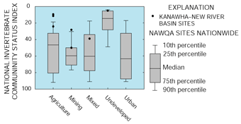
Invertebrate communities at two coal mining stream sites ranked near the middle of more than 600 NAWQA sites sampled nationwide during 199198. These sites had index scores better than national median scores for urban sites, about the same as national median scores for agricultural sites, and worse than national median scores for undeveloped sites. The community at a forested and undeveloped site in the Appalachian Plateaus was within the best 10 percent of NAWQA sites nationally and within the best 25 percent of undeveloped sites. Nationally, invertebrate communities at heavily agricultural sites were commonly highly impaired. In the KanawhaNew River Basin, agriculture is usually of low intensity and centers on pasturing small herds of cattle and growing cattle feed. Invertebrate communities at two agricultural sites, one in the Appalachian Plateaus and one in the Blue Ridge Physiographic Province, were within the best 10 percent of all sites nationally. |

Some Contaminants are Widespread and Present at Potentially Harmful Concentrations in Streambed Sediment and Fish Tissue
Ten Polycyclic Aromatic Hydrocarbons were Found in Streambed Sediments in Concentrations that may Harm Aquatic Life
Forty samples of streambed sediment from 36 sites in the KanawhaNew River Basin were analyzed for polycyclic aromatic hydrocarbons (PAHs) during 199698. PAHs are components of wood smoke, diesel exhaust, soot, petroleum, and coal. Their toxicity varies, and some are carcinogenic to humans and other animals. Of the 12 PAHs for which guidelines were available, 10 were detected at concentrations exceeding the Probable Effect Level (PEL; see information box on sediment-quality guidelines), and all were detected at concentrations exceeding the Threshold Effect Level (TEL).
High concentrations of PAHs were present in each physiographic setting in the basin except for the Blue Ridge, although the only high concentrations in the Valley and Ridge/Appalachian Plateaus transition zone were in basins where coal has been mined. The highest PAH concentrations measured in this study were in the Appalachian Plateaus. Some of the highest PAH concentrations were measured at some of the most heavily mined sites in the basin, although the correlation between coal production and streambed PAH concentration was weak (r² = 0.52, among 20 wadeable stream sites within the coal region). Coal samples from several commonly mined seams in West Virginia were between 20 and 85 percent PAH by mass (W.H. Orem, U.S. Geological Survey, written commun., July 2000). Coal particles are common in sediment from many streams in the coal fields. The PAHs from the coal particles, however, may not be bioavailable (Chapman and others, 1996). Unlike other NAWQA study areas, no correlation was found between most other land uses and PAH concentration.
| Sediment Quality Guidelines |
Four Trace Elements were Present in Streambed Sediment in Concentrations That May Harm Aquatic Life
A total of 53 bed-sediment samples from 47 sites in the KanawhaNew River Basin were analyzed for trace elements during 199698. All eight of the trace elements for which criteria were available were found at some sites in concentrations exceeding their Threshold Effect Level (fig. 16; see information box on sediment-quality guidelines). Nickel, chromium, zinc, and lead were detected at concentrations exceeding their Probable Effect Level. Nickel concentrations exceeded the Probable Effect Level most frequently (in 47 of the 53 samples), based on the 1995 Sediment Quality Guidelines; a final SQG was not issued for nickel at the time that other SQGs were finalized.
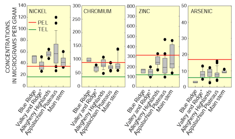 |
| Figure 16. Some trace element concentrations in streambed sediment exceeded Environment Canada's effects-based criteria at several sites in the basin. Probable effects levels (PEL) are those concentrations at which harmful effects to aquatic life are thought to be likely, and were exceeded most frequently in the Allegheny Highlands and other Appalachian Plateaus streams. Threshold effects levels (TEL) were exceeded at all sites by nickel and chromium. *Valley and Ridge sites include transition zones between provinces. |
Trace-element concentrations also were determined in livers of common carp or rock bass in 27 samples from 18 sites in 1996 and 1997. Some samples contained concentrations of arsenic, cadmium, lead, mercury, nickel, selenium, and zinc that were among the highest 25 percent of more than 900 NAWQA samples nationwide (199198). Concentrations of cadmium, mercury, nickel, selenium, and zinc in fish-tissue samples from the KanawhaNew River Basin ranked among the highest 10 percent of all NAWQA samples; six samples contained cadmium concentrations ranking among the highest 10 percent of all NAWQA samples, and five samples contained selenium concentrations ranking among the highest 10 percent of all NAWQA samples. One fish-tissue sample, from Kanawha River at Winfield, contained cadmium at a concentration ranking in the highest 1 percent of all samples in the Nation. Determining the human health or ecological significance of these concentrations is problematic, because tissue samples were collected from many different species and because fish-liver tissue is not normally eaten by humans.
| Table of Contents || Previous Section || Next Section || Glossary U.S. Geological Survey Circular 1204 Suggested citation:
|
