
MAJOR FINDINGS
Nutrient concentrations in streams and rivers are a major concern
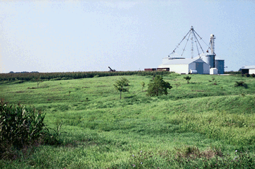 |
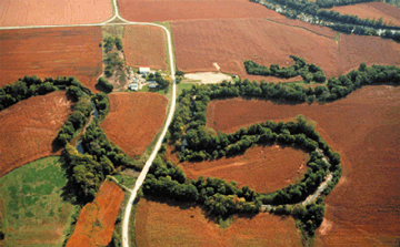
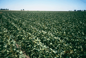
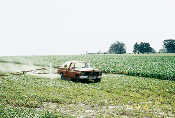
| Figure 7. Farming and related businesses are major activities in the lower Illinois River Basin. Agriculture has a significant effect on water quality and wildlife habitat. (Photograph by David J. Fazio, USGS.) |
Agriculture is the most important activity in the lower Illinois River Basin from an economic and water-quality perspective (fig. 7). Application rates of nitrogen and phosphorus in synthetic fertilizer and manure are among the highest in the Nation. The high application rates of agrichemicals in the basin were reflected by the kinds and amounts of contaminants found in streams, rivers, and ground water. Nevertheless, contaminants associated with urban or industrial activities also were detected in some streams, rivers, and wells.
Flow-weighted concentrations of nitrate (nitrate as nitrogen) were generally highest in small streams in intensive agricultural areas and east of the Illinois River (fig. 8). The lowest flow-weighted mean concentration of nitrate was for the Illinois River at Valley Citythe outflow from the basin. Concentrations of nutrients were similar at the basin inflow (Illinois River at Ottawa) and the basin outflow (Illinois River at Valley City). Urban sources, primarily wastewater effluent, however, were major contributors at the inflow [4], whereas agriculture provided most of the nutrient contribution to the water resources within the basin.
 |
| Figure 8. Mean nitrate concentrations generally are lowest in the Illinois River. Nitrate concentrations in the three largest rivers show a downward trend with increasing streamflow from the Sangamon River near Oakford to the Illinois River at Ottawa and to the Illinois River at Valley City. The La Moine River, which is the only river or stream sampled that lies entirely within the Galesburg Plain physiographic subsection, does not fit the general trend. The nitrate concentrations are flow-weighted means. |
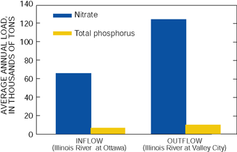
The nitrate load (amount of nitrate in water that moves past a location on the river) measured at the outflow from the basin, 124,000 ton/yr (tons per year), was nearly twice the load measured at the inflow, 66,000 ton/yr (fig. 9). Flow-weighted mean concentrations of nitrate are similar between the two Illinois River locations; therefore, the difference in loads is directly related to the difference in streamflow (fig. 6). The lower Illinois River Basin contributes roughly the same amount of nutrients to the Mississippi River as does the upper Illinois River Basin, which includes the Chicago urban area and rural areas in Illinois, Indiana, and Wisconsin.
The annual nitrogen yield (amount of nitrogen in water that flows out of the watershed divided by the area of the watershed) measured at the river and stream locations ranged from 4.6 to 12 (ton/mi²)/yr (tons per square mile per year), the smallest yields being measured in the largest river and the largest yields measured in the smallest streams. The overall yield for the basin (Illinois River at Valley City) was 4.6 (ton/mi²)/yr during 199598.
 |
|
| Figure 9. About twice as much nitrate and total phosphorus leaves the lower Illinois River as enters it. The loads for the upper Illinois River Basinthe basin upstream from Ottawaare about one-half of the respective loads for the lower Illinois River Basin. |
Substantial differences among nutrient concentrations in small agricultural basins and the lower nutrient concentrations in large rivers indicate that hydrological and biochemical processes reduce the nitrate concentration as nitrate moves through the basin and into the Mississippi River. Instantaneous concentrations of nutrients varied with season: nitrate concentrations were highest during the winter and spring and lowest in the late summer and fall.
Sites on the largest riversthe Illinois River at Ottawa and Valley City and the Sangamon River near Oakfordhad the highest flow-weighted mean concentrations of total organic nitrogen, ammonia nitrogen, and phosphorus; the latter two are indicators of urban wastewater effluent [4]. The Sangamon River near Oakford had the highest flow-weighted mean concentration of total organic nitrogen, ammonia nitrogen, and phosphorus. Samples from middle-sized La Moine River at Colmar generally had higher flow-weighted mean concentrations of most nutrients compared with samples from the Sangamon River at Monticello, which also is middle sized but is at the eastern edge of the basin. Flow-weighted mean concentrations of nitrate in samples from the Sangamon River at Monticello, however, were greater than those in samples from the La Moine River at Colmar. Panther Creek near El Paso, a small-basin site, generally had higher concentrations of most nutrients than did Indian Creek near Wyoming, another small-basin site.
| What Was Assessed? The NAWQA Program was not intended to assess the quality of the Nation's drinking water, such as by monitoring water from household taps. Rather, NAWQA assessments focus on the quality of the resource itself, thereby complementing many ongoing Federal, State, and local drinking-water monitoring programs. Comparisons made in this report to drinking-water standards and guidelines are made only in the context of the available untreated resource. |
Stream and river samples often exceeded the nitrate drinking-water standard and phosphorus guideline
Flow-weighted mean concentrations of nitrate for five of the eight sample locations in the basin, including two locations on the Sangamon River (used for public water supplies), were higher than the Maximum Contaminant Level (MCL) of 10 mg/L nitrate as nitrogen established for drinking water.
The concentration of total phosphorus in most samples (80 percent) from all streams and rivers exceeded the 0.1 mg/L guideline recommended by USEPA to prevent eutrophication in streams. Samples from Indian Creek near Wyoming had the highest concentrations of total phosphorus, and samples from Panther Creek near El Paso had the smallest. Indian Creek near Wyoming is downstream from a small wastewater-treatment plant, which is likely the reason for the higher total phosphorus at this site.
Nitrate concentrations were lower than in other areas of the Corn Belt during late summer
During August 1997, concentrations of dissolved nitrate and total nitrogen were found to be lower in streams and rivers of the lower Illinois River Basin than in some other areas of the Midwest. A synoptic study was done at 70 sites with drainage areas between 100 and 1,000 mi² in Illinois, Iowa, and Minnesota in August 1997, when streamflow had approximately reached the annual minimum [5]. Median concentrations of dissolved nitrate in streams generally increased northwestward, from Illinois (0.52 mg/L) to Iowa (1.5 mg/L) to Minnesota (3.5 mg/L). No significant relations between nitrate concentrations and streambank characteristics or soil permeability were identified. Streams that have formed on windblown glacial materials, however, generally had lower concentrations than streams formed on glacial till (unsorted material left behind by continental glaciers). The windblown materials typically have slightly higher permeability than the glacial till and are more likely to allow rainwater to infiltrate rather than run off to streams.
In Illinois, rainfall and thus runoff to streams was low before and during synoptic sampling; therefore, most streamflow was derived from ground-water seepage. Thus the low nutrient concentrations in ground water in the basinmuch lower than those in streams and riversare a major reason why low nitrate concentrations were detected in the streams during August 1997 in the basin.
Differences in moisture conditions and precipitation during the 3-month period before the August sampling (wettest in Minnesota and driest in Illinois) probably also contributed to the differences in concentrations across the three-State region. The percentages of total nitrogen present as organic nitrogen and ammonia were higher in Illinois than in other parts of the study area. Nitrogen incorporation in algae also was a factor in the distribution of dissolved nitrate. Algal communities, particularly phytoplankton, were more stable and productive in Illinois than in other parts of the three-State synoptic study, and much of the nitrogen in the aquatic system was incorporated into these plant communities in the basin.
Nitrate concentrations differed upstream and downstream from water-supply reservoirs
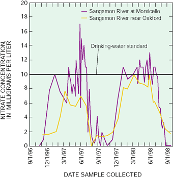 |
| Figure 10. Nitrate concentration in the Sangamon River is affected by reservoirs and other factors. Monticello lies upstream from several water-supply reservoirs and the cities of Springfield and Decatur. Oakford lies downstream from the reservoirs. The reservoirs are for water supply, and during spring they are replenished by river water that exceeds the drinking-water standard for nitrate. Water leaving the reservoirs usually does not exceed the nitrate standard and has less variability in nitrate concentrations. |
Dissolved nitrate concentrations in samples from the Sangamon River (at Monticello) were found to be more variable upstream from several water-supply reservoirs than downstream from the reservoirs (fig. 10). From April through June, nitrate concentrations were frequently above the MCL of 10 mg/L (highest concentration, 17 mg/L) in the Sangamon River at Monticello, 29 mi upstream from Lake Decatur, the drinking-water source for the city of Decatur. The city of Decatur often must treat water for nitrate above the MCL during spring and early summer or mix the high-nitrate surface water with ground water to lower the nitrate concentration. Nitrate concentrations also were highest in the spring in the Sangamon River near Oakford, which is downstream from Lake Decatur and other water-supply reservoirs used by the city of Springfield. Concentrations in samples from the Sangamon River near Oakford, however, seldom exceeded the nitrate MCL.
Conversely, concentrations of nitrate usually were less than 1 mg/L in the Sangamon River at Monticello from August through November, but typically remained higher than 1 mg/L at the Oakford site during the same period. Data from Scribner and others [6] indicate that nitrate concentrations of reservoirs in corn- and soybean-producing areas of the Midwest have nutrient concentrations and patterns similar to those in the Sangamon River near Oakford.
|

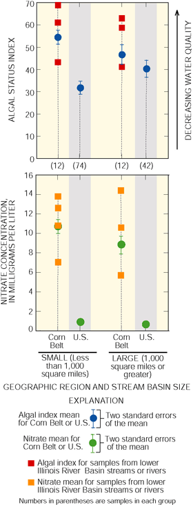
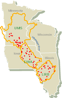
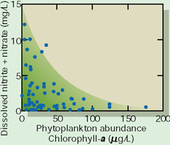
Despite similar land use throughout the Corn Belt region of the Midwest, streams flowing through cropland differ considerably in their ecological characteristics, in part because of differences in riparian buffer zones (see text boxes). This conclusion is based on an investigation of 70 streams and rivers within three NAWQA Study Units in the upper Midwest during August 1997 (figure at right) [5; 7]. Specifically, increases in tree cover in buffer zones were associated with aquatic biological communities indicative of good stream quality, reduced nuisance algal growths, and maintenance of sufficient dissolved oxygen concentrations to support diverse communities of aquatic organisms. For example, the number of aquatic insects indicative of good stream quality tended to increase with increases in percentage of tree cover, especially in sites where streamflow and dissolved oxygen conditions were favorable. Fish communities, sampled at 24 sites in the UMIS Study Unit, also indicated better overall conditions in streams with wooded riparian zones than those with more open canopy [8]. Streams with less tree cover, and thus less shading, contained relatively large growths of phytoplankton (algae suspended in the water) at levels considered indicative of eutrophication [9]. Organic enrichment resulting from excessive algal production in some midwestern streams may reduce dissolved oxygen concentrations and be detrimental to other requirements of aquatic organisms. Shading from tree cover in riparian buffer zones may influence nutrient concentrations indirectly by reducing the growth of phytoplankton. In streams where phytoplankton were abundant (often where buffer zones were thin or lacking), dissolved nitrate concentrations were significantly lower (figure below) [9]. The lower nutrient concentrations may result from uptake by the abundant phytoplankton. Thus, assessments of eutrophication would benefit from consideration of biological communities and the riparian zone, rather than being based solely on nutrient concentrations in the water.
|

|

Nitrate concentrations in some shallow wells exceeded the drinking-water standard
 |
|
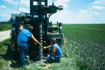
| Figure 11. Study-Unit staff installed 57 wells to sample recently recharged ground water. Assistance and geological expertise was provided by the Illinois State Geological Survey. (Photograph by William S. Morrow, Jr., USGS.) |
The 117-well network sampled in the basin consisted of 57 shallow monitoring wells installed for the study (fig. 11) and 60 water-supply wells of various types. Although the concentrations of nitrate in none of the 30 samples from the deep Mahomet aquifer exceeded the MCL (all concentrations were below 0.10 mg/L), nitrate concentrations in the shallow wells exceeded the MCL in 7 percent (6 of 87) of the shallow-well samples. Concentrations above the MCL ranged from 11 to 77 mg/L. All exceedances of the nitrate MCL were in samples from wells less than 50 feet deep.
An important reason for fewer detections and much lower concentrations of nitrate and other agrichemicals in ground water is artificial drainage (where present) and the geological materials from which the soils developed. Most farmland in Illinois is artificially drained by ditches and subsurface drains (tile drains) because of the poor natural drainage of the soils and their parent materials (fig. 12). Artificial drainage short circuits infiltrating water to streams through the subsurface drains rather than allowing the water to move downward to the water table or to deeper aquifers [15]. Subsurface drainage also decreases the amount of potential runoff across land surface to streams because the soil is less saturated and ponding is less likely [15]. Another factor that helps prevent agrichemicals from reaching wells is that the fine-grained materials may be conducive to rapid breakdown of many of the chemicals.
 |
| Figure 12. Subsurface drainage allows water with high concentrations of agrichemicals to be transported directly to ditches and streams. The outlet pipe from a subsurface drain at center of photograph is draining into the stream. (Photograph by Kelly L. Warner, USGS.) |
One-half of the shallow wells installed for monitoring recently recharged ground water (28 of 57) were installed in the geological materials overlying the Mahomet aquifer. The shallow ground water in this area has a high potential for eventually recharging the underlying Mahomet aquifer [2]. Sampling results from these wells indicate the Mahomet aquifer is fairly well protected from contamination at land surface.
Some pesticides were always detected in streams and rivers
Herbicides are applied during spring planting to virtually all corn and soybean crops in the basin. Insecticides are applied during the summer to about 10 to 30 percent of the corn crop, depending on weather conditions. Approximately 6,000 to 6,700 tons of agricultural pesticides were applied annually in the lower Illinois River Basin during 199698 (data from [1618]).
Atrazine, which is commonly applied to corn in the basin, and its breakdown products (hydroxyatrazine, deisopropylatrazine, and deethylatrazine) were the most frequently detected pesticide and related compounds in streams throughout the basin and shallow ground water beneath cropland. Atrazine was detected in every stream sample collected from the basin, even during winter. Prometon, which is not used in appreciable amounts on cropland but commonly is applied for weed control in rights-of-way in the basin, was detected frequently in streams (93 percent of samples) and infrequently in shallow ground water (7 percent of samples).
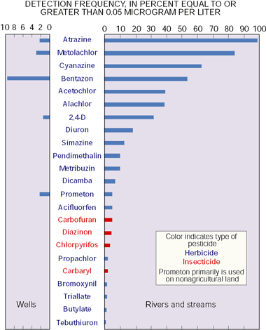 |
| Figure 13. Many commonly applied pesticides were frequently detected in streams and rivers in the lower Illinois River Basin. Detections in ground water were far fewer, and some of the pesticides frequently detected in surface water (such as cyanazine, acetochlor, and alachlor) were not detected in shallow ground water at or above the common reporting level of 0.05 micrograms per liter. |
In samples collected at Illinois River at Valley City (basin outflow), 40 pesticides or pesticide breakdown products were detected. Atrazine and metolachlor were always present, and cyanazine was detected in 97 percent of the samples.
Because the method detection limit varies widely from one pesticide or related compound to another, a common reporting level is used to compare detections of the pesticides and compounds on an equal basis. In figure 13, the frequency of detection of pesticides in stream and river samples and ground-water samples is shown at a common reporting level of 0.05 µg/L. Of the pesticides detected in 1 percent or more of samples, those shown in figure 13, only 2,4-D had a higher method detection limit than 0.05 µg/L; therefore the detection frequency of 2,4-D may be underestimated in figure 13. Even at the common reporting level, atrazine was detected in almost all stream and river samples.
Pesticide concentrations in streams periodically exceeded drinking-water standards
Concentrations of atrazine and cyanazine in some individual samples exceeded USEPA drinking-water standards or guidelines. Annual average concentrations of each compound in streams and rivers, however, were below their respective MCL (atrazine: 3 µg/L) or lifetime health advisory level (HAL) (cyanazine: 1 µg/L). Carbofuran, diazinon, chlorpyrifos, and carbaryl were the only insecticides detected. Diazinon concentration exceeded the Great Lakes water-quality objective (0.08 µg/L) [19] in one sample at Illinois River at Valley City during August 1998.
![Figure 14. During late spring and early summer, many pesticides exceeded drinking-water standards or guidelines or aquatic-life guidelines. The graph shows concentrations of selected pesticides in the La Moine River at Colmar during part of 1997. (Registration limit for acetochlor is from [21]; ALC, Aquatic-Life Criterion from [20]; HAL, Health Advisory Level.)](images/lirb_fig14.gif) |
|
| Figure 14. During late spring and early summer, many pesticides exceeded drinking-water standards or guidelines or aquatic-life guidelines. The graph shows concentrations of selected pesticides in the La Moine River at Colmar during part of 1997. (Registration limit for acetochlor is from [21]; ALC, Aquatic-Life Criterion from [20]; HAL, Health Advisory Level.) |
Some pesticide concentrations that exceeded human health standards or guidelines also were potentially toxic to aquatic life. For example, an atrazine concentration of 110 µg/L in a single sample from the La Moine River at Colmar (fig. 14) exceeded not only the USEPA MCL (3 µg/L) but also the Canadian guideline for the protection of freshwater aquatic life (1.8 µg/L) [20]. In samples from the Illinois River at Ottawa and at Valley City and the Sangamon River at Oakford, all exceedances of the cyanazine HAL and the metolachlor aquatic-life guideline (7.8 µg/L) were concurrent with an exceedance of the atrazine MCL. In contrast, diazinon concentrations twice exceeded the Great Lakes water-quality objective and one chlorpyrifos concentration exceeded the aquatic-life guideline (0.041 µg/L) independent of all other pesticide exceedances.
In samples from the La Moine River at Colmar and the Sangamon River at Monticello, for every pesticide other than atrazine, concentrations exceeded a drinking-water standard or guideline concurrent with an atrazine MCL exceedance. The lone exception was cyanazine, which exceeded the HAL independent of all other standard or guideline exceedances. Currently (2000), drinking-water standards or guidelines and aquatic life guidelines have been established only for individual pesticides. Furthermore, USEPA drinking-water MCLs or HALs are established for only 25 of the 40 pesticides detected in the lower Illinois River Basin. Pesticides, however, commonly are found in mixtures of as many as 21 compounds in surface water (fig. 15). Although most samples of shallow ground water contained relatively few detectable concentrations of pesticides compared to samples from streams and rivers, two or more pesticides were detected in all samples where any of pesticides were detected at all. The health effects of such combinations of pesticides in drinking water, even in low concentrations, are not well understood.
Pesticide concentrations in streams have a seasonal pattern
Herbicide concentrations in stream and river samples are highest in late spring to early summer (fig. 16), and insecticide concentrations typically peak in midsummer. The highest pesticide concentrations typically occur during the first one or two periods of storm runoff after pesticide application. During seasonal peaks, concentrations of pesticides in samples of stream water exceeded drinking-water standards or guidelines or aquatic-life guidelines. For example, for about 6 weeks after herbicide application in the spring, concentrations of atrazine at Illinois River at Valley City were greater than the MCL of 3 µg/L. The annual mean atrazine concentration in the Illinois River at Valley City for 1996 through 1998, however, never exceeded the MCL. Peak concentrations of the insecticides diazinon and chlorpyrifos were measured during July or August of 1997 or 1998. Insecticides are often applied later in the growing season than herbicides.
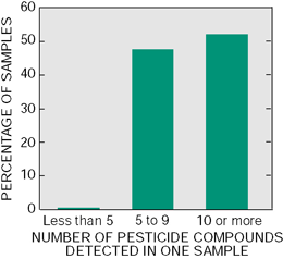 |
| Figure 15. Most samples from streams and rivers contained multiple pesticides and related compounds. Five or more compounds were detected in more than 90 percent of samples. The maximum number of compounds detected at or above the method detection limit in one sample was 21. |
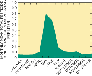 |
| Figure 16. Pesticide concentrations vary seasonally. The sum of pesticide concentrations in samples peaks in late spring during runoff from rainstorms. Often, runoff from spring rains supplies reservoirs on some rivers and streams with a substantial amount of the water storage for the remainder of the year. Monthly mean totals are for all locations sampled for pesticides during October 1996September 1998. |
Many factors affect the presence and concentration of pesticides in streams
 |
| Figure 17. Pesticides are used to protect crops and increase production. Pesticides are often sprayed directly on the plants in the field. Other pesticides are incorporated into the soil, partly to limit the amount of chemical that leaves the field. (Photograph by Kelly L. Warner, USGS.) |
The presence and concentration of pesticides in streams in the lower Illinois River Basin are influenced by land use and agricultural practices (fig. 17) such as pesticide application rate, drainage of crop land, and cropping methods. Natural factors, such as the size of the streams, type of terrain, and soil characteristics, also are important determinants. In addition, the distribution of individual pesticides in streams throughout a watershed depends on the physical and chemical properties of the pesticides that are in useproperties such as sorption (the ability of a pesticide to stick to soil particles), transformation (the ease with which a pesticide breaks down in the environment), and volatilization (the tendency of a pesticide to become gaseous and rise into the atmosphere).
Concentrations of agricultural chemicals generally reflect application rates
The most heavily applied pesticides (more than 1 million pounds of active ingredient per year; acetochlor, atrazine, cyanazine, and metolachlor) were generally the most frequently detected in streams and shallow aquifers. Herbicides such as alachlor and simazine, which are no longer applied as heavily as in previous decades, still are detected at relatively high rates. Bentazon is not applied as heavily as other herbicides, yet it is frequently detected in stream and well samples (fig. 18).
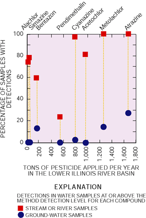 |
| Figure 18. Detection rates in streams are mainly affected by the amount of pesticide applied in the basin. Detection rates in ground water, even for those pesticides that are heavily applied, are much lower. |
Pesticide concentrations in water also were commonly related to drainage of water over and through agricultural soils, pesticide uptake by plants and microbes, and attachment to soil particles. Pesticide and nutrient persistence and regional differences in soils, geology, and climate govern the distribution of these water-quality indicators in the lower Illinois River Basin.
The relatively infrequent detection of metolachlor in well samples may be related to the following factors:
- Metolachlor is applied after weeds sprout and emerge, and it is taken up by plants and is converted to other compounds.
- Soil microbes effectively degrade metolachlor.
- Soils retain metolachlor instead of allowing it to run off or seep downward to ground water.
Stream size affects pesticide concentrations
In the lower Illinois River Basin, pesticide concentrations in small streams typically range from the highest to the lowest observed concentrations, whereas concentrations in large rivers are moderate and less variable. For example, during the period when most pesticides are washed into streams (May through July), the maximum concentration of atrazine measured in the Sangamon River at Monticello was about twice as high as that measured in the Illinois River. The highest concentrations of several pesticides, including atrazine (110 µg/L; May 1997), acetochlor (12 µg/L; May 1998), cyanazine (16 µg/L; May 1997), and 2,4-D (7.3 µg/L; May 1998) were detected in samples from the La Moine River at Colmar. In contrast, in months other than May or June, 70 percent (35 of 50) of samples from Sangamon River at Monticello had total pesticide concentrations that were less than 1 µg/L, as compared with 79 percent (26 of 33) of the samples from Illinois River at Valley City. Samples for analysis of pesticides were not collected from the smallest streams monitored.
| Table of Contents || Previous Section || Next Section || Glossary U.S. Geological Survey Circular 1209 Suggested citation:
|
