
INTRODUCTION TO THE LOWER ILLINOIS RIVER BASIN
The lower Illinois River Basin (the basin) encompasses 18,000 mi² (square miles) of central and west-central Illinois between the upper end at Ottawa and the confluence of the Illinois River with the Mississippi River near Grafton. The basin includes all of 22 counties and parts of 19 counties.
As of 1990, 1.3 million people lived in the basin. More than 50 percent of the population lived in the counties of Macon, McLean, Peoria, Sangamon, and Tazewell. The four most populated cities are Peoria, Springfield, Decatur, and Bloomington. The basin population decreased by 7 percent from 1980 to 1990 [2].
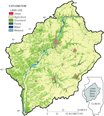 |
| Figure 1. Land use in the lower Illinois River Basin is predominantly agriculture. Farming is most intensive in the part east of the Illinois River. Streambanks generally are steeper west of the Illinois River and are more forested than streambanks east of the river. |
Agriculture is the predominant land usetypically corn and soybean row crops. Agriculture accounts for 88 percent of the overall land area, whereas forests account for 7 percent and urban areas account for about 2 percent (fig. 1). The remaining land use, about 3 percent, is mostly grassland, wetland, or water.
The small-stream basins that were sampled during 199598 have even higher percentages of land devoted to farming; for example, the Panther Creek Basin is 99 percent agricultural land (fig. 2). The lower Illinois River Basin has some of the most highly productive and intensively cultivated farmland in the world. As a result, application rates of farm-related chemicals are among the highest in the country in support of corn and soybean production. Runoff from these vast, flat farm areas carries relatively high concentrations of nutrients and pesticides into the small streams and major rivers of the basin.
Animal farming is also a significant industry in the basin [2], and runoff from manure spreading is a contributor to some of the highest levels of nitrate and total nitrogen found in the rivers and streams of the United States.
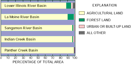 |
| Figure 2. Proportion of land devoted to agriculture varies only slightly among basinsfrom 88 percent in the entire lower Illinois River Basin to 99 percent in the Panther Creek Basin. |
Study design in relation to land use
Chemical and biological samples were collected from a range of river and stream sizes in different landscape types and from shallow aquifers. A deep aquifer (Mahomet aquifer) was sampled to assess the overall water quality. A group of the shallow large-bore wells used for domestic (private household) supply was sampled, as well as other shallow domestic wells, to assess overall water quality and determine the occurrence of human-induced contaminants and the extent of land-use effects on recently recharged ground water.
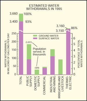 |
| Figure 3. Water withdrawals in the lower Illinois River Basin are dominated by thermoelectric withdrawals (cooling water for power generation). Drinking water is supplied roughly equally from surface-water reservoirs and ground-water supplies. |
In the lower Illinois River Basin, 48 percent of the public- or municipal-supply water is drawn from ground-water sources and 52 percent from surface-water sources (fig. 3). All private-supply water, usually for domestic use, is from ground water. Rural residents (about 25 percent of the population) generally are self-supplied from ground water [2]. In most of the western and southern parts of the basin, homeowners rely on cisterns or large-diameter dug or bored wells [3]. These large-diameter wells are highly susceptible to contamination from surface-water runoff and shallow ground water.
Irrigation, which is confined to sandy soils near the center of the basin, is entirely supplied by ground water.
Hydrologic conditions during the study period
Rainfall generally was near normal during the data-collection period (fig. 4). Typically, the largest rainstorms are during April to July. The generally normal rainfall had exceptions; in particular, water year 1997 (October 1996September 1997) was slightly drier than normal, and spring 1996 had fewer storms than normal.
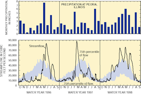 |
| Figure 4. Hydrologic conditions during the data-collection period were near normal. Some relatively dry periods resulted in below-normal flow, and several wet periods resulted in above-normal flow on the Illinois River at Valley City. |
Ground-water levels reflected the near-normal rainfall conditions, particularly in the southern part of the basin (fig. 5). Shallow ground water typically is recharged in late winter and early spring, then the level falls during the summer growing season. Water level in a representative well is shown in figure 5, along with 10 years of annual rainfall data collected near Peoria, which lies near the center of the basin.
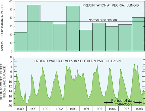 |
| Figure 5. Ground-water conditions were near normal during 198998, including the data-collection period. In 1993, the observation-well water level shows the effect of the significant 1993 flood on the shallow ground water. (Data from K. Hlinka, Illinois State Water Survey, and National Weather Service.) |
The Illinois River is a navigable waterway that connects the Mississippi River to Chicago and the Great Lakes. Barges carrying grain and other commodities are a significant influence on suspended sediment and water quality. The mean annual flow of the Illinois River increases from about 12,600 ft3/s (cubic feet per second) at Ottawa to 22,600 ft3/s at Valley City [2]. Five major tributariesVermilion River, Spoon River, Mackinaw River, La Moine River, and Sangamon Riverand many smaller streams join the Illinois River (fig. 6). Flow gaging and sampling of the outflow from the basin is done at Valley City because the water level of the Mississippi River, at times, affects the flow of the Illinois River downstream from Valley City.
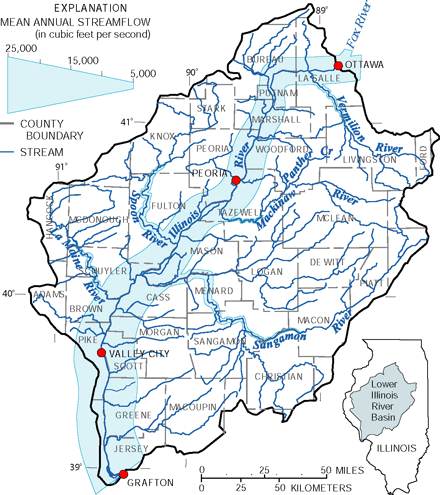 |
| Figure 6. The lower Illinois River has five major tributaries. The inflow to the basin is at Ottawa, Ill., where the Fox River joins the Illinois River. Where the Illinois River leaves the basin and enters the Mississippi River near Grafton, Ill., the outflow is almost double that of the inflow. |
| Table of Contents || Previous Section || Next Section || Glossary U.S. Geological Survey Circular 1209 Suggested citation:
|
