
INTRODUCTION TO THE EASTERN IOWA RIVER BASIN
The Eastern Iowa Basins Study Unit encompasses the Wapsipinicon, the Cedar, the Iowa, and the Skunk River Basins and encompasses about 19,500 mi² (square miles) in eastern Iowa and southern Minnesota (fig. 1). The four major rivers in the Study Unit generally flow in a southeasterly direction and empty into the Mississippi River. The basins of these four major rivers are relatively long and narrow. The Wapsipinicon River originates in southeastern Minnesota and extends about 225 mi (miles) to its confluence with the Mississippi River. The Wapsipinicon River Basin has a drainage area of 2,540 mi². The Cedar River originates in southern Minnesota and joins the Iowa River about 30 mi upstream from the mouth of the Iowa River. The Iowa River originates in north-central Iowa. The Iowa and the Cedar River Basins cover 12,640 mi², more than 90 percent of which is in Iowa. The Skunk River originates in central Iowa and drains about 4,350 mi².
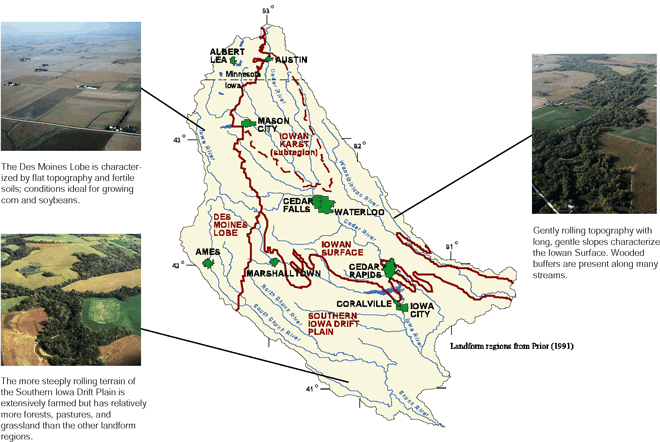 |
| Figure 1. Glacial deposits formed three major landforms with characteristic soils and topography in the Eastern Iowa Basins. |
Geology
Glaciers created a land surface with three distinct regions in the Eastern Iowa Basins Study Unit: the Des Moines Lobe, the Iowan Surface, and the Southern Iowa Drift Plain (fig. 1). The Des Moines Lobe is characterized by low relief with some distinct ridges near the eastern boundary and occasional depressions that form lakes, ponds, and swamps. Glacial till is the dominant surficial material, and alluvium is present along the streams. Poorly drained soils have developed on the tills. The Iowan Surface has gently rolling topography with long slopes, low relief, and a mature drainage pattern. The surficial material is primarily glacial drift with thin layers of windblown loess on the ridges and alluvium near the streams. A subregion of the Iowan Surface (Iowan Karst) was defined for this study in an area where bedrock is close to the land surface. In the Southern Iowa Drift Plain, streams have eroded deeply into the glacial drift and loess mantle to produce a steeply rolling terrain with broad, flat drainage divides. Moderately well-drained soils have developed on the loess.
Climate
Water originates as rainfall in late spring through late fall and as snow during winter and early spring. Average annual precipitation in the basins ranges from about 30 inches in the northwestern part of the Study Unit to about 36 inches in the southeast. The greatest rainfall typically occurs during the growing season in spring and summer. The mean April-to-October precipitation is about 25 inches. The most intense 24-hour rainfall (5-year recurrence interval) can be more than 4 inches. Snowfall has been recorded from September to May. The greatest 24-hour snowfall seldom (less than 25 percent of the years) exceeds 10 inches. Yearly rainfall during the study period ranged from below average in 1996 to about average in 1997 and above average in 1998.
Land Use
Because water flows over the land surface or infiltrates the soil, human activities may have a substantial effect on the quality of ground and surface water. The production of row crops, such as corn, and cover crops, such as alfalfa and small grains, constitutes the major land use in the Study Unit. Land near the streams and rivers has a combination of crops and forests. About 40 percent of the more than 1 million people in the Study Unit are concentrated in cities with populations greater than 20,000.
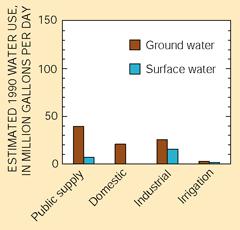 |
| Figure 2. An abundant ground-water resource provides water to municipalities, homes, and industry. Ground water is used by more than 90 percent of the population in the Study Unit. |
Water Use
Water used for household, municipal, commercial, industrial, and agriculture purposes originates primarily from ground water. Surface water, although an important supply for several larger cities including Cedar Rapids and Iowa City, is used primarily for cooling water in the generation of electric power.
Water that infiltrates through the soil into underlying sand and gravel deposits and ultimately into the underlying bedrock formations is used as a water supply for about 94 percent of the population in the Eastern Iowa Basins Study Unit. Rivers and streams are the source of public-water supplies for about 6 percent of the population (fig. 2).
Surface Water
Excess precipitation that does not infiltrate into the soil or evaporate runs off to the streams (fig. 3). Generally, poorly permeable till soils typical of the Des Moines Lobe and steeper slopes typical of the Southern Iowa Drift Plain generate greater overland flow than the moderately well drained loess soils and gentle slopes typical of the Iowa Surface. Overland flow to streams is slowed or reduced by grass, perennials, shrubs, and trees (riparian buffers) where present near streambanks. Runoff to streams averages about 25 percent of the annual precipitation and ranges from less than 7 inches per year in the northern part of the Study Unit to about 9 inches per year in the southeastern part. Overland flow and ground-water discharge are the major sources of streamflow. However, tile lines may be an important source to streams during base flow in areas where they have been installed to remove standing water from surface depressions and to lower the water table.
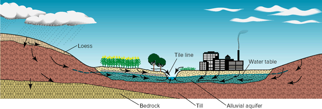 |
| Figure 3. In the Eastern Iowa Basins, water originating from precipitation flows overland or through loess, till, and alluvial deposits to nearby streams. Areas with high water tables and poor natural drainage have commonly been artificially drained with tile lines. (Graphic created by Suzanne Roberts, U.S. Geological Survey.) |
Long-term yearly discharge from the Eastern Iowa Basins Study Unit averages about 9.2 million acre-feet. The overall increase in rainfall from 1996 to 1998 was reflected in the substantial increase in yearly stream discharge (fig. 4). Yearly discharge from the Eastern Iowa Basins increased from about 8.6 million acre-feet in 1996 to almost 13.8 million acre-feet in 1998. Yearly discharge was not uniform in the major basins. Discharge from the Wapsipinicon and Iowa River Basins increased in 1997 and 1998, and the discharge from the Skunk River Basin decreased from 1996 to 1998.
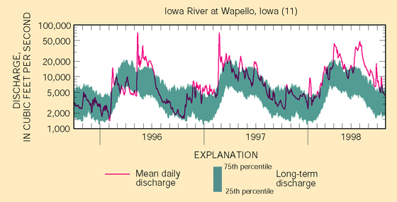 |
| Figure 4. Stream discharge in the Eastern Iowa Basins ranged from below normal in 1996 to near normal in 1997 and above normal in 1998 (site number in parentheses; see site map in Study Unit Design section). |
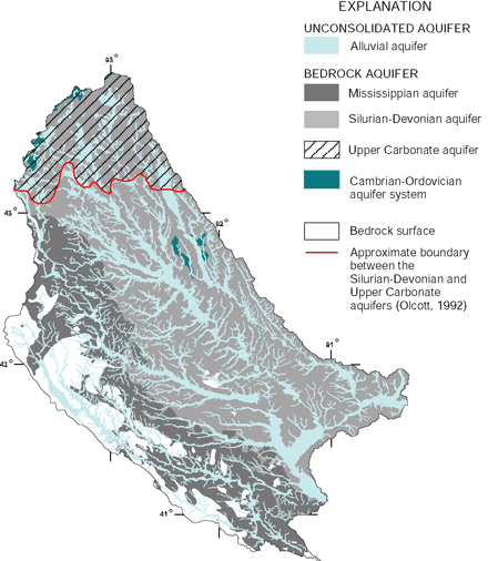 |
| Figure 5. Several major bedrock and unconsolidated aquifers are used as sources of water for domestic, municipal, and industrial supplies. Only the most heavily used aquifers, the Silurian-Devonian and Upper Carbonate aquifers and the alluvial aquifers, were sampled. |
Ground Water
Water from rainfall infiltrates through the soil and, depending on whether permeable sand, gravel, and fractured bedrock are present, may continue to move to the deeper aquifers (fig. 3). If low-permeability clay or shale lies below the unconsolidated surficial materials, water may move laterally to a nearby stream.
Alluvial material that has been deposited by rivers and streams commonly consists of sand and gravel layers that store and transmit water readily. The alluvial aquifers (fig. 5) are the most frequently used source of ground water in the Eastern Iowa Basins because they are near land surface and can supply large amounts of water. The same properties (shallow depth and permeable material) that make alluvial aquifers excellent sources of water also make the alluvial aquifers susceptible to contamination from surface activities.
Two additional surficial deposits, not assessed during this study, provide water for domestic and municipal supplies. Sand and gravel deposits in low-permeability glacial till generally yield small quantities of water that are used mostly for rural domestic and stock supplies. Also, deep sand and gravel deposited in bedrock valleys before the last glacial advance is an important source of water in parts of the Eastern Iowa Basins.
Rock formations (bedrock) generally underlie the clay, silt, sand, and gravel surficial materials and can provide water for use. Bedrock aquifers are generally deep and are protected from surficial contamination. However, in areas such as the Iowan Karst, bedrock is exposed or is covered by very thin unconsolidated deposits and is susceptible to contamination from urban and agricultural land uses.
The most extensively used bedrock aquifers are the Silurian-Devonian and Upper Carbonate aquifers. The Silurian-Devonian and Upper Carbonate aquifers consist mainly of limestone and dolomite with locally interbedded shale and evaporite beds. Bedrock aquifers that are used as a source of water in the Study Unit but were not evaluated during this study are the Mississippian aquifer and the Cambrian-Ordovician aquifer system.
| Table of Contents || Previous Section || Next Section || Glossary U.S. Geological Survey Circular 1210 Suggested citation:
|
