SUMMARY OF MAJOR FINDINGS
 |
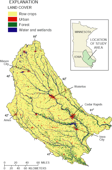
| The Eastern Iowa Basins Study Unit encompasses the Wapsipinicon, the Cedar, the Iowa, and the Skunk River Basins and covers about 19,500 mi2 in eastern Iowa and southern Minnesota. In 1990, about 40 percent of the more than 1 million people in the Study Unit were concentrated in cities with populations of greater than 20,000 people. Cedar Rapids is the only city with a population greater than 100,000. Ground water is the major source for municipal, industrial, and domestic supplies. During the study, Iowa City was the largest municipal user of surface water. Over 90 percent of the land in the Study Unit is used for agricultural purposes. Forested areas account for only 4 percent of the land. Data from Eros Data Center, 1994. |
Highlights Nitrogen and phosphorus concentrations in streams in the Eastern Iowa Basins Study Unit rank as some of the highest in the Corn Belt (see map, p. 8) as well as the Nation and were higher than the drinking-water standard in many samples. These conditions reflect intensive use of the land for growing crops and dense populations of livestock in some basins.
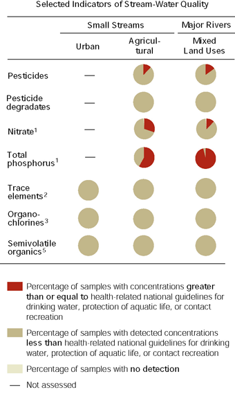
- Nitrate concentrations in 22 percent of the stream samples exceeded the U.S. Environmental Protection Agency (USEPA) drinking-water standard of 10 mg/L (milligrams per liter). The standard was most frequently exceeded during June, soon after spring fertilizer application. Although many of the streams sampled are not currently used for drinking-water supplies, the Cedar and Iowa Rivers are the direct or indirect source for Cedar Rapids and Iowa City—two of the largest cities in the study area.
- The highest nitrate concentrations occurred in medium-sized streams draining basins with the most intensive row-crop agriculture and in a stream draining a basin with both intensive row-crop agriculture and dense concentrations of large-scale animal feeding operations. Nitrate concentrations in these streams exceeded 10 mg/L in almost 50 percent of the samples. Conversely, nitrate concentrations were lowest in basins that had greater percentages of pasture, grassland, and forest.
- Total phosphorus concentrations frequently (75 percent of the samples) exceeded the 0.1-mg/L USEPA-recommended goal to minimize algal growth in rivers. Total phosphorus concentrations were greatest in streams and rivers that drain basins with more highly erodible soils and in large river basins that contain the largest cities and towns in the Study Unit.
- The large amounts of nitrogen and phosphorus that are transported to the Mississippi River from the Study Unit represent an economic loss to farmers and a potential environmental threat to downstream waters. The estimated annual loss of 17 to 41 lb/acre (pounds per acre) of nitrogen and 1.2 to 1.5 lb/acre of phosphorus represents a potential loss in crop yield or the cost of additional fertilizer needed to compensate for that flushed from the fields. Nutrients transported to the Mississippi River likely reach the Gulf of Mexico where they contribute to eutrophication and hypoxia.
- Although the use of herbicides and insecticides in the Study Unit is among the most intense nationwide, herbicide concentrations in streams were not among the highest 25 percent nationally, and insecticide concentrations were in the lowest 25 percent nationally. Breakdown compounds (degradates), whose widespread occurrence has only recently been discovered and about which little is known of the human and environmental effects, generally accounted for the majority of the pesticide compounds present in rivers and streams.
-
The most commonly used herbicides were the most frequently detected and were generally present in the greatest concentrations. Atrazine and metolachlor were detected in all stream samples. Concentrations generally ranged from 0.1 to 1.0 µg/L (microgram per liter). Atrazine concentrations exceeded the USEPA 3.0-µg/L drinking-water standard in about 10 percent of the samples; exceedances occurred mainly during late-spring runoff.
- Acetochlor, a conditionally registered herbicide that is intended to replace several other commonly used herbicides, was frequently detected, but concentrations were less than 0.1 µg/L in 75 percent of the samples. Mean annual acetochlor concentrations did not exceed the 2.0-µg/L USEPA registration requirement at any site, but concentrations did exceed that level in about 3 percent of the individual samples. The maximum concentration measured during the study (10.6 µg/L) exceeded the level that would require biweekly sampling by water-supply systems.
- Alachlor, metolachlor, and acetochlor degradates are present in relatively high concentrations throughout the year, indicating that they are more persistent than their parent compounds.
- Carbofuran and chlorpyrifos, insecticides that have been identified as posing a high risk to aquatic insects and mussels, were present in as much as 60 percent of the monthly samples during the summer when these insecticides are normally applied.
- Riparian buffer zones influence the quality of water in streams and rivers. Biological communities respond to tree density in riparian buffer zones. Invertebrate taxa indicative of good stream quality increased with increased numbers of trees. In contrast, streams that were not shaded by trees contained large algal growths considered indicative of eutrophication.
| Major influences on streams and rivers
|
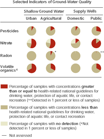
Compared to surface water, ground water in the Eastern Iowa Basins had substantially lower nutrient concentrations and less frequent detections. Land use, however, had a substantial effect on the quality of water in alluvial aquifers. Pesticide degradates were some of the most commonly detected constituents in these aquifers. Nitrate and methyl tert-butyl ether (MTBE) exceeded the USEPA standard or advisory in some of the samples. In contrast, bedrock aquifers, which are generally protected by clay and shale layers, typically had low nitrate concentrations and low frequency of pesticide detections.
- Nitrate concentrations generally decreased with depth in the alluvial aquifers. Biological denitrification may result in decreased nitrate concentration with depth, but it is also possible that the deeper water infiltrated during past years when less fertilizer was used for crops.
- Nutrients move from ground water to streams by natural drainage and tile lines. Nitrate concentrations in 24 of 25 medium-sized streams exceeded 10 mg/L during the sampling period in May 1998 when streamflow originated primarily from ground-water discharge. Nitrate concentrations consistently exceeded 10 mg/L in water from a selected tile line draining to the Iowa River.
- Pesticides were detected in alluvial aquifers underlying both agricultural and urban areas, but shallow ground water in agricultural areas contained greater concentrations than urban areas. A greater variety of pesticide compounds was detected in urban areas than agricultural areas, reflecting a more diverse usage.
- Pesticides most commonly detected in the alluvial aquifers underlying urban areas were atrazine, prometon, and metolachlor. Pesticide concentrations did not exceed established drinking-water standards.
- With the exception of atrazine and metolachlor and prometon in urban areas, pesticides were infrequently detected in alluvial aquifers. Pesticide degradates generally were more commonly detected in the alluvial aquifers than their parent compounds. The greater presence of degradates indicates that many pesticides break down in the soil and that the resulting pesticide degradates are transported to the shallow aquifers.
- MTBE, a common gasoline additive used to increase the octane content or ensure cleaner burning, was detected in 23 percent of samples from alluvial aquifers in urban areas. Concentrations exceeded the USEPA drinking-water advisory in samples from 6 percent of the wells.
 |
| Major influences on ground water
|
| Table of Contents || Previous Section || Next Section || Glossary U.S. Geological Survey Circular 1210 Suggested citation:
|

