
INTRODUCTION TO THE CENTRAL ARIZONA BASINS
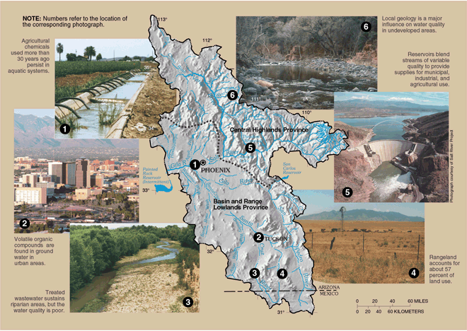
The Central Arizona Basins (CAZB) Study Unit encompasses a 34,700-square-mile area in central and southern Arizona and northern Mexico (fig. 1). The Study Unit includes large parts of two hydrologic provincesthe Central Highlands in the north and the Basin and Range Lowlands in the south (U.S. Geological Survey, 1969). Climate, hydrology, geology, land use, and water use are distinctly different in these two provinces.
The Central Highlands (fig. 1) have minimal development and are generally representative of natural conditions. Mountainous terrain with shallow, narrow intermountain basins predominates in the Central Highlands (Cordy and others, 1998). Forests and rangeland cover most of the province. The largest population is in the town of Prescott35,785 (Arizona Department of Economic Security, rev. July 7, 2000), and small rural towns dot the region. Agricultural development is minimal except in the northernmost tip of the CAZB.
 |
| Figure 1. The Central Highlands hydrologic province is mountainous compared to the large, elongate alluvial basins of the Basin and Range Lowlands. Reservoirs capture the perennial streams of the Central Highlands to provide water supplies for the Basin and Range Lowlands. |
Most of the perennial streams in the Study Unit are in the Central Highlands (fig. 2). These streams derive their flow from mean annual precipitation of more than 25 inches in the mountains and from rainfall and snowmelt along the Mogollon Rim, which forms the northeastern border of the CAZB Study Unit.
Major streams having their headwaters in the Central Highlands include the Salt,Verde, and Agua Fria Rivers (fig. 2). These rivers flow year around (perennial) in their upper reaches but are captured for water supply for metropolitan Phoenix, power generation, and flood control before they reach the Basin and Range Lowlands.
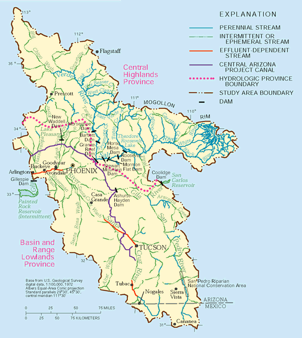 |
| Figure 2. Perennial streams in the Central Highlands, Colorado River water from the Central Arizona Project Canal, ground water, and treated sewage effluent fulfill water demands in the Basin and Range Lowlands. |
Though streams provide most of the water for agricultural use in the Central Highlands, ground water is the main source for municipal and industrial supply (fig. 3). Much of the ground water is pumped from sedimentary deposits of limited extent in the valleys. As a result, some of the fastest-growing towns are being forced to seek alternative water supplies (Arizona Department of Water Resources, 1994). Natural factors such as dissolution of minerals in rocks and basin sediments are major influences on ground-water quality in the Central Highlands (Owen-Joyce and Bell, 1983; Marsh, 2000); however, activities such as mining have affected water quality locally (Brown and Favor, 1996).
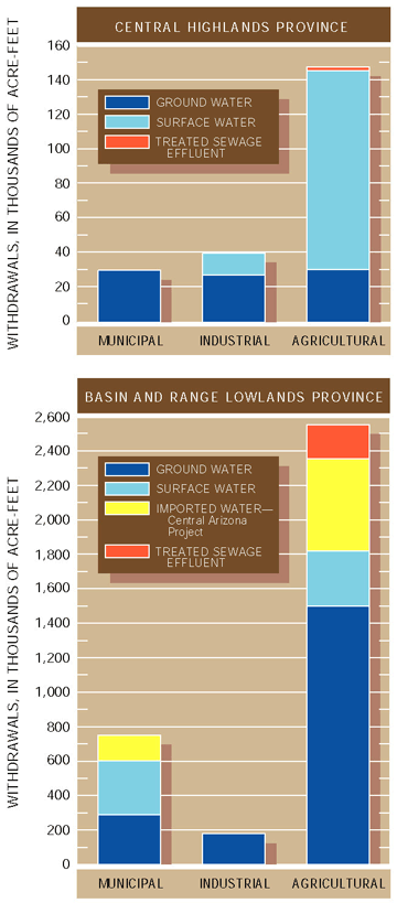 |
| Figure 3. Water-use data for 1990 show the many sources of water used to meet demands in the CAZB Study Unit. |
The Basin and Range Lowlands (fig. 1) are characterized by a lack of perennial streams, the largest water demands, and reliance on ground water. Deep, broad alluvial basins separated by mountain ranges of small areal extent characterize this hydrologic province. The basins are filled with thick deposits of gravel, sand, silt, and clay and include interbedded evaporite deposits and volcanic rocks in places (Anderson and others, 1992). These basin-fill sediments can be 2,000 feet to as much as 12,000 feet thick and constitute the major aquifers that are often referred to as basin-fill aquifers. The basin-fill aquifers contain large reserves of ground water that were recharged when Arizonas climate was much wetter than at present, possibly thousands of years ago.
Ephemeral streams are characteristic of the Basin and Range Lowlands (fig. 2). Very little natural streamflow is generated because the average annual rainfall is less than 10 to 15 inches except at the highest elevations. With the exception of some small, higher elevation streams and sections of the San Pedro River, most perennial streams in the Basin and Range Lowlands are effluent-dependent; that is, their flow is sustained all year by treated wastewater (fig. 2). Effluent-dependent streams have beneficial uses. They support riparian and aquatic communities where those communities would not otherwise exist. By recharging effluent, cities can accrue credits toward pumping of ground water from other locations in a basin (Arizona Department of Water Resources, 1994).
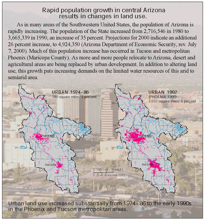
Rangeland is the predominant land use in the Basin and Range Lowlands. The two largest urban areasPhoenix and Tucsonaccount for about 5 percent of the land use and include 75 percent of Arizonas 4.9 million people (Arizona Department of Economic Security, rev. July 7, 2000). Agricultural development, which is mostly west and south of Phoenix, is about 5 percent of the land use (Cordy and others, 1998). Cropland is the primary agricultural land use, and cotton is the main crop.
Water use in the Basin and Range Lowlands represents 96 percent of all water use in the CAZB Study Unit (Cordy and others, 1998). Agriculture is the largest water user (73 percent in 1990; fig. 3). Because of the general lack of surface-water resources in the Basin and Range Lowlands, ground-water is relied upon heavily to meet agricultural and municipal demands (fig. 3). In areas with substantial agricultural and (or) urban development, ground water has been and continues to be used more quickly than it can be replenished naturally. Ground-water levels have declined several hundred feet in areas with the heaviest pumping, and land subsidence has resulted in a loss in aquifer storage capacity (Arizona Department of Water Resources, 1994). To mitigate some of the problems caused by overpumping of ground water, Colorado River water is delivered to central Arizona by the Central Arizona Project (CAP) canal (fig. 2). CAP water is used for aquifer recharge and municipal and agricultural purposes.
 |
The study design focused on the effects of land use on water quality. Water, sediment, and biological samples were collected from streams in urban, agricultural, forest, and rangeland areas of the CAZB Study Unit to assess the overall quality of streams as well as the effects of specific land-use practices on stream-water quality (U.S. Geological Survey, 1999). At most sites, water samples were collected monthly from late 1995 through early 1998, and at some stream sites additional samples were collected during storms to assess the effects of stormwater runoff on water quality. Two stream sites were sampled twice monthly for 1 year to determine the occurrence and distribution of pesticides. A single round of sampling for contaminants in streambed sediment and fish tissue was completed in 199596 (See Study Unit Design, p. 26).
Ground water was sampled from wells in three alluvial basins in the Basin and Range Lowlandsthe West Salt River Valley, the Upper Santa Cruz Basin, and the Sierra Vista subbasin. Existing wells were sampled in the three basins to assess overall water quality as well as the effects of human activities on water quality. In the West Salt River Valley, shallow monitoring wells were installed and sampled to determine the effects of irrigated agriculture on shallow ground-water quality. Existing ground-water-quality data were used to assess overall water quality in alluvial basins of the Basin and Range Lowlands that were not sampled.
This report is organized into sections on stream-water quality and ground-water quality. In each section, natural water quality, that is water that has been minimally affected by agricultural or urban development, is discussed followed by a discussion of the effects of human activities on water quality. This organization is designed to assist the reader in understanding the changes in natural water quality that result from human activities.
Understanding climatic and hydrologic conditions during the sampling period, 199598, is useful in interpreting the CAZB study results. The climate of the Study Unit is characterized by variability from place to place and also by large differences in precipitation from one year to the next. Precipitation can be three times greater in wet years than in dry years (Cordy and others, 1998). In Central Highlands streams, represented by the Verde River below Tangle Creek (fig. 4), daily mean streamflow was successively higher from 1996 through 1998. Streamflow in 1998 generally was greater than the median of historical daily streamflow, and streamflow in 1996 was less than the median of historical daily streamflow (fig. 4).
Streamflow in the Basin and Range Lowlands is difficult to characterize because it is controlled by dams and (or) wastewater-treatment plants. The Hassayampa River near Arlington is an example of a Basin and Range Lowlands stream that is a combination of effluent and irrigation return flows most of the time, supplemented by flows from storm runoff (fig. 4). Streamflow at the site typically was less than the median historical daily streamflow during 1996 and 1997; however, summer streamflow in those years was greater than the median historical daily streamflow because of increased summer thundershowers. Streamflow during 1998 was about the same as the median of historical daily streamflow.
When streamflow exceeds baseflow as a result of rainfall or snowmelt runoff, dissolved-solids concentrations decrease in streams and reservoirs because of dilution. Nutrient concentrations increase with increased streamflow because precipitation and runoff carry more nutrients to streams.
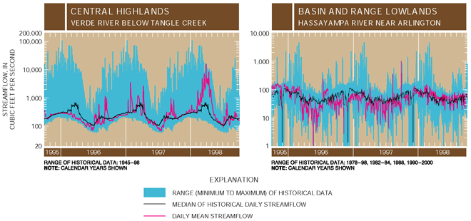 |
| Figure 4. Streamflow in the Central Highlands increased each year from 199698 as indicated by the Verde River below Tangle Creek. In the Basin and Range Lowlands, streamflow is difficult to characterize because it is controlled by dams and (or) wastewater-treatment plants. For the Hassayampa River near Arlington, a Basin and Range Lowlands stream, summer streamflow in 1996 and 1997 was greater than the median historical daily value. |
| Table of Contents || Previous Section || Next Section || Glossary U.S. Geological Survey Circular 1213 Suggested citation:
|
