
MAJOR FINDINGS
In the CAZB Study Unit, perennial streams draining areas with little or no agricultural or urban land use represent baseline or natural conditions in the basins. These natural streams are referred to as forest/rangeland streams in this report because they drain basins that are 93 to 100 percent forest and (or) rangeland. Examples of forest/rangeland streams include the upper Verde, upper Salt, and upper Gila Rivers and West Clear Creek in the Central Highlands province and the upper San Pedro River in the Basin and Range Lowlands province. Because some of the forest/rangeland streams provide drinking water for Phoenix or recharge aquifers used for drinking water, the quality of these streams is compared to drinking-water standards and guidelines as well as to other water-quality criteria.
The water quality of forest/rangeland streams is primarily determined by natural factors. Processes such as chemical weathering of bedrock and soils, biological activity in soils (Likens and others, 1977), ground-water discharge to streams, and runoff determine the water quality of these streams. Locally, stream-water quality may be affected by agriculture, mining, or urban land use.
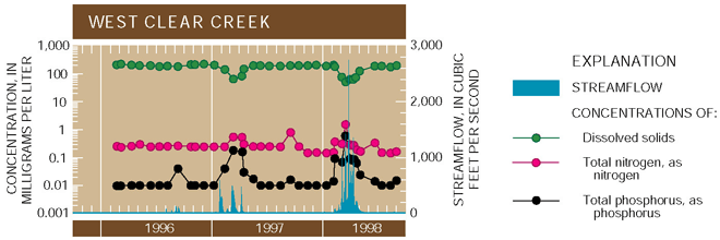
Nutrient and dissolved-solids concentrations fluctuate seasonally in forest/rangeland streams. The patterns of rainfall and snowmelt runoff account for the seasonal fluctuations in concentrations of nutrients (fig. 5). Nutrient concentrations increase in streams during times of rainfall and snowmelt runoff because runoff carries nutrients washed off the land surface to streams, thereby increasing concentrations. Nitrogen in rainfall and snowmelt also adds to nutrient concentrations in streams. Conversely, during low streamflows, nutrient concentrations are lower because very little runoff reaches streams, and aquatic life in the streams take up the available nutrients.
Seasonal patterns of dissolved-solids concentrations are opposite to those of nutrients. During periods of low flow, the sources of streamflow are springs, which in some areas, such as the upper Salt River Basin, are quite saline (Feth and Hem, 1963). During periods of runoff, flow in streams is diluted, which lowers the dissolved-solids concentrations (fig. 5).
 |
| Figure 5. Concentrations of nutrients increase and concentrations of dissolved solids decrease during rainfall or snowmelt runoff. |
Nitrate concentrations in forest/rangeland streams were significantly lower than the U.S. Environmental Protection Agencys (USEPA) Maximum Contaminant Level (MCL) of 10 mg/L. Nitrate was detected in 43 percent of the samples from forest/rangeland streams. None of the nitrate concentrations exceeded the MCL, which was established for the protection of human health (fig. 6), and less than 2 percent of the samples had concentrations of nitrate that were greater than the estimated national background concentration in streams of 0.6 mg/L (U.S. Geological Survey, 1999). Concentrations greater than background levels are generally considered to be the result of human activities. Samples that exceeded the background concentration were collected during high flows associated with rainfall or snowmelt runoff.
Twenty-four percent of the samples from forest/rangeland streams exceeded the USEPA desired goal for total phosphorus of 0.1 mg/L for the prevention of nuisance plant growth (fig. 6). The USEPA desired goal of 0.1 mg/L is the same as the estimated national background concentration for phosphorus (U.S. Geological Survey, 1999). Phosphorus enrichment in streams can lead to eutrophication; however, in the forest/rangeland streams, phosphorus concentrations exceeding the USEPA goal are generally limited to periods of rainfall and snowmelt runoff.
Dissolved-solids concentrations exceeded the USEPA Secondary Maximum Contaminant Level (SMCL) in 76 percent of samples from the upper Salt River. None of the samples from the upper San Pedro River or West Clear Creek exceeded the SMCL of 500 mg/L that is based on taste of drinking water (fig. 6). Samples that exceeded this drinking-water guideline were collected at times when streamflow was sustained by flow from springs. Saline springs drain into the upper Salt River (Feth and Hem, 1963), which accounts for the particularly large number of samples that exceeded the SMCL.
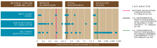 |
| Figure 6. Nitrate concentrations in forest/rangeland streams are significantly lower than the maximum contaminant level of 10 mg/L. Most water samples from the upper Salt River exceeded the secondary maximum contaminant level for dissolved solids (500 mg/L) because saline springs sustain streamflow during periods of low flow. |
Total DDT concentrations in fish tissue samples from forest/ rangeland streams were significantly less than the New York State guideline (Newell and others, 1987) for the protection of fish-eating wildlife. None of the other organochlorine pesticides and PCBs analyzed for were detected in fish tissue from forest/rangeland streams (Gebler, 2000). In addition, organochlorine compounds and PCBs were not detected in streambed sediment from these streams.
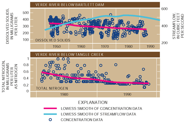
Stream water quality generally is improving on the basis of nutrient and dissolved-solids concentrations in forest/rangeland streams. Statistical analysis of nitrogen data for forest/rangeland streams indicates that concentrations have generally declined since the early 1980s (fig. 7). Phosphorus concentration data showed the same trend as nitrogen. In the upper, undeveloped parts of the Salt and Verde River Basins (upstream from reservoirs) the decrease in nutrients could be from a decrease in contributions from natural sources (see p. 10), a decrease as a result of better land-use management practices upstream, and (or) an increase in nitrogen use by aquatic life.
Dissolved-solids concentrations decreased substantially in outflow from reservoirs on the Verde River from 195090 (fig. 7). This downward trend, also seen on the Salt River, probably is caused by both increased rainfall and snowmelt runoff diluting the dissolved-solids concentrations and physical and chemical processes in the reservoirs that remove some dissolved solids from solution.
 |
| Figure 7. Water quality of forest/rangeland streams has improved, on the basis of decreases in dissolved-solids and nutrient concentrations during the past 30 to 50 years. |
Effects of Human Activities on Stream Water Quality
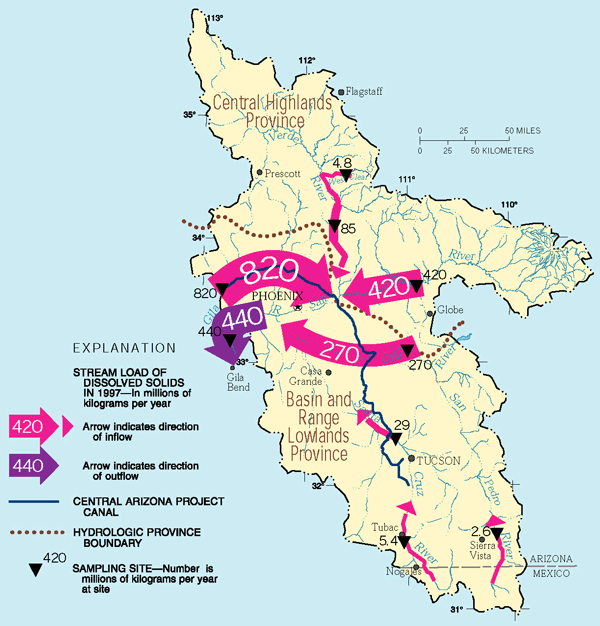
Streams affected by human activities may have elevated concentrations of dissolved solids and nutrients from a variety of activities including urban and agricultural runoff. Manmade compounds such as pesticides and volatile organic compounds (VOCs) in streams are a direct result of human activities. To determine the factors affecting water quality in the CAZB, annual stream loads of dissolved solids (the mass of material transported in the water) entering the basins were compared to annual stream loads leaving the basins (see story below). In addition, the quantifiable sources of nitrogen and phosphorus (nutrients) coming into major basins and leaving in streamflow were used to identify basins where water quality is affected by human activities (see p. 10). Water-quality characteristics of affected streams are indicative of the local effects of human activities.
Streams sampled in the CAZB that are affected by human activities can be divided into two main categorieseffluent-dependent and agricultural/urban. Streamflow in effluent-dependent streams is almost entirely treated sewage effluent discharged from waste-water-treatment plants (WWTPs). These streams are referred to in this report as effluent-dependent or effluent-dependent urban streams (see p. 12) because the effluent reflects urban land uses. Some sampling sites in the CAZB receive irrigation return flows and rainfall runoff from agricultural fields as well as treated effluent, and these streams are referred to as agricultural/urban streams.
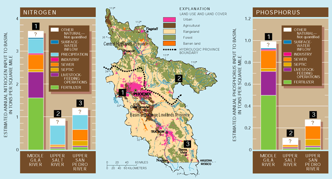
| What are the sources of nitrogen and phosphorus in basins? Major sources of nitrogen and phosphorus that
can be quantified include fertilizers, livestock-feeding operations
(commercial feedlot and dairy operations), inputs to sewer and septic
systems, atmospheric deposition, industrial wastes, and streamflow
into basins. For the CAZB Study Unit, the quantities of nitrogen
and phosphorus contributed by each source annually were determined
for selected drainage basins. Sources were quantified using records
of fertilizer sales by county, livestock population counts, population
and housing census information, National Atmospheric Deposition
data for Arizona, USEPA Toxic Release Inventory data, and stream
water-quality data collected in the CAZB for the NAWQA Program (Anning,
1998). The quantifiable sources of nitrogen and phosphorus in three
basins are shown in figure 9.
|
How much nitrogen and phosphorus actually leaves the CAZB Study Unit in streams? A small fraction of nutrients applied to the
land surface in the CAZB is tranported to streams. The lack of rainfall
in the Study Unit limits the tranport of nutrients into streams
and out of the basins. For the middle Gila River Basin, which includes
most of the CAZB Study Unit, about 1,100 tons of nitrogen and 500
tons of phosphorus left the basin in 1998; these nutrient loads
represent 1 percent of the quentifiable nitrogen and 2 percent of
the quantifiable phosphorus for the basin. During 1996 and 1998,
only 1 to 21 percent of the nitrogen and 3 to 48 percent of the
phosphorus from quantifiable sources were transported out of basins
in the CAZB in streamflow (D.W. Anning, U.S. Geological Survey,
written commun., 1999). |
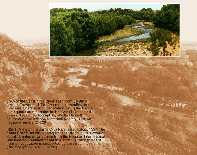
| Effluent-dependent streams are valuable water resources in the CAZB In many of the urban areas in Arizona, treated
sewage effluent from wastewater-treatment plants is discharged into
otherwise dry streambeds. Less than a century ago, some of these
"effluent-dependent" streams, such as the Santa Cruz River
in Tucson (see below) and the Salt River in Phoenix, had natural
perennial streamflow, but ground-water pumping, damming of rivers,
or other human activities have resulted in a loss of natural streamflow
and associated riparian and aquatic communities (Tellman and others,
1997).
|
Effluent-dependent streams
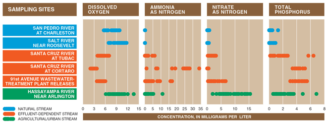
Nutrient concentrations in effluent-dependent streams exceeded the background concentrations found in forest/ rangeland streams (see fig. 11). The 91st Avenue WWTP outfall near Phoenix and the Santa Cruz River at Tubac and at Cortaro Road (Tucson; see p. 26 for location of sites) are effluent-dependent streams that were sampled in the CAZB. Data from the San Pedro River at Charleston and the Salt River near Roosevelt represent background values for nutrients in the CAZB because these streams drain areas with relatively little urban or agricultural land use. By comparison, the nutrient concentrations at the effluent-dependent sites in the CAZB are elevated because the effluent discharged directly into the stream channels is a major source of nitrogen and phosphorus (U.S. Geological Survey, 1999).
Effluent-dependent streams can sustain riparian communities and aquatic life, but the water quality is poor. Some effluent-dependent streams in the CAZB can support valuable riparian communities with high biodiversity of terrestrial plants and animals; however, dissolved oxygen and phosphorus concentrations in these streams indicate that the water-quality is poor. At a minimum, most fish need 3 to 5 mg/L of dissolved oxygen (DO) over a long period of time to survive (Swenson and Baldwin, 1965). At the Santa Cruz River at Cortaro, DO concentrations were commonly lower than 3 mg/L (fig. 11), whereas concentrations at the other two effluent-dependent sites were in the minimal range. All the samples from the effluent-dependent streams exceeded the USEPAs desired goal for phosphorus of 0.1 mg/L for prevention of nuisance plant growth (eutrophication) (U.S. Environmental Protection Agency, 1986). Excessive algae and aquatic plant growth can lead to low DO concentrations (U.S. Geological Survey, 1999).
 |
| Figure 11. Nutrient enrichment in effluent-dependent streams contributes to abundant algal growth, which results in decreased dissolved oxygen and limited aquatic communities. |
The level of sewage treatment and the distance effluent travels downstream from the discharge point influence the water quality of effluent-dependent streams. Ammonia concentrations in effluent at the Santa Cruz River at Cortaro are extremely variable and typically higher than those in the Santa Cruz River at Tubac or the 91st Avenue WWTP (fig. 11). Effluent at the Cortaro site has had secondary treatment, which results in nitrogen remaining in the effluent as ammonia (David Garrett, Pima County Wastewater, oral commun., 2000). In contrast, effluent sampled at the discharge point from the 91st Avenue WWTP has had tertiary treatment in which the ammonia is converted to nitrate. Converting ammonia to nitrate during treatment limits the direct threat of toxicity to fish that ammonia presents, but it does not change the potential for eutrophication of the stream (Mueller and others, 1996).
The lowest nutrient concentrations in effluent-dependent streams were at the Santa Cruz River at Tubac (fig. 11). Effluent in this stream receives secondary treatment and travels about 15 miles downstream to Tubac. As the effluent moves downstream, ammonia is lost to the atmosphere or converted to nitrate, some nitrate and phosphorus are taken up by plants and aquatic life, and phosphorus may be adsorbed by streambed sediments. Each of these processes reduces concentrations of nitrogen and (or) phosphorus, resulting in lower concentrations with distance downstream from the WWTP.
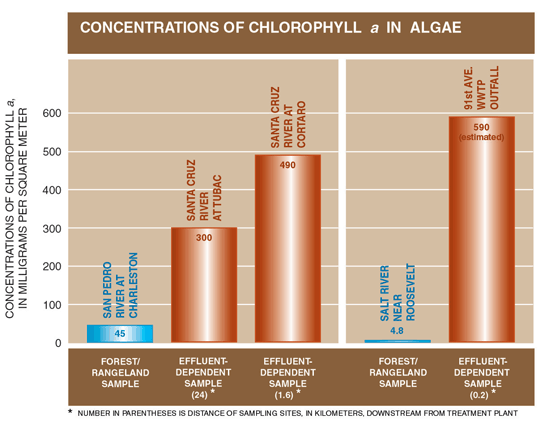
Abundant algal growth from nutrient enrichment in effluent-dependent streams may adversely affect aquatic organisms. Phosphorus, nitrate, and ammonia in effluent-dependent streams encourage algal growth. Chlorophyll a concentrations (fig. 12), which are indicators of the quantity of algae in a stream, were much higher in effluent-dependent streams than in forest/rangeland streams (Gebler, 1998).
Abundant algal growth and the resulting increase in decaying organic material in effluent-dependent streams can cause decreased DO concentrations, particularly at night when plants cease photosynthesis and decrease their oxygen production. The decreased DO can adversely affect aquatic invertebrates and fish.
 |
| Figure 12. Nutrients in effluent-dependent streams encourage algal growth, as indicated by chlorophyll a concentrations. |
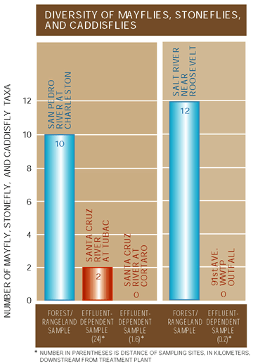
Effluent-dependent streams support limited instream communities of aquatic invertebrates. The diversity of pollution-sensitive aquatic invertebrates such as myflies, stoneflies, and caddisflies in effluent-dependent streams is very low, especially when compared to the high diversity in forest/rangeland streams (fig. 13). Pollution-tolerant species of aquatic worms and midges account for more than 90 percent of the numbers of aquatic invertebrates in effluent-dependent stream reaches sampled in the CAZB (fig. 14). In forest/rangeland streams, mayflies, stoneflies, and caddisflies were the most abundant of all aquatic invertebrate groups, which is consistent with good water quality and instream habitat (Gebler, 1998).
|
| Figure 13. Aquatic invertebrate communities in effluent-dependent streams lack diversity. |
Organochlorine pesticides and PCBs in streambed sediment and fish tissue from effluent- dependent streams exceeded guidelines for protection of aquatic life and fish-eating wildlife. Probable effect levels (PELs) for sediment (Canadian Council of Ministers of the Environment, 1999) were exceeded for DDE and total chlordane in samples from the 91st Avenue WWTP and at a site near the discharge point from the Nogales WWTP into the Santa Cruz River. The PEL is a concentration above which adverse effects to aquatic organisms are predicted to occur frequently. Exceedance of the PEL concentrations indicates that bottom-dwelling aquatic organisms may be adversely affected by toxicity. Total DDT (91st Avenue WWTP) and PCBs (Santa Cruz River at Tubac) in fish-tissue samples exceeded New York State guidelines (Newell and others, 1987) for the protection of fish-eating wildlife. These guidelines are being applied to findings from NAWQA Study Units nationwide. DDT, which breaks down to form DDE and DDD, is associated with past use of DDT in agricultural areas. Use of DDT was discontinued in Arizona in 1969. PCBs were primarily used in industrial and urban settings, but their use was discontinued in 1979. Exceedances of tissue guidelines can result in reduced reproductive ability and other possible adverse effects in wildlife that eat contaminated fish (Faber and Hickey, 1973).
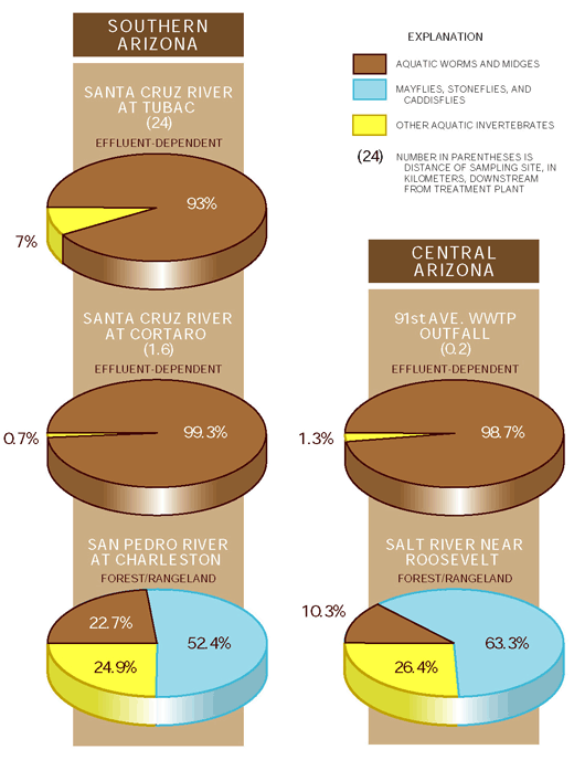 |
| Figure 14. Pollution-tolerant aquatic invertebrates are most abundant in effluent-dependent streams. |
Agricultural/urban streams
As in effluent-dependent streams, nutrient concentrations in agricultural/urban streams were elevated compared with concentrations in forest/rangeland streams (fig. 11). This is no surprise given that the two agricultural/urban streamsBuckeye Canal near Avondale and Hassayampa River near Arlingtonreceive effluent from the 91st Avenue WWTP in Phoenix. The effluent is mixed with ground water in Buckeye Canal and used to irrigate cotton and other crops. Downstream, effluent and irrigation return flows in Buckeye Canal are discharged into the Hassayampa River near Arlington. At this point, the water has been used and reused for agricultural irrigation, and nitrate concentrations are typically higher than those in the original effluent (fig. 11) because of the use of fertilizers in the agricultural area near Buckeye.
Herbicides were detected in streams soon after application to agricultural lands, but concentrations did not exceed guidelines for protection of aquatic life. In the West Salt River Valley west of Phoenix, the pre-emergent herbicides dacthal, EPTC, simazine, and trifluralin are applied to tilled fields prior to cotton planting in the early spring to control weeds. They may be reapplied in the fall to fields where winter crops are grown. These herbicides were detected in surface-water samples from the agricultural/urban streams in the early spring and fall, soon after application. Changes in concentrations of dacthal at the Hassayampa River near Arlington (fig. 15) are representative of the patterns seen for herbicide concentrations at both sites. Agricultural and rainfall runoff carry these pesticides to streams. Because streamflow at these sites is not used for drinking water but does sustain aquatic life, guidelines for the protection of aquatic life were used to evaluate water quality. Aquatic-life guidelines for simazine and trifluralin were not exceeded in any samples from these sites. There are no aquatic-life guidelines for dacthal and EPTC.
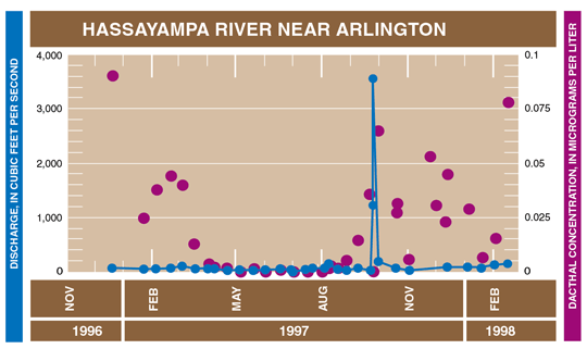 |
| Figure 15. Herbicides were detected in streams soon after being applied to crops. |
Organochlorine pesticides that persist in streambed sediment and in fish tissue from an agricultural/urban stream are a concern for aquatic ecosystem health. PEL concentrations for sediment were exceeded for DDE and DDT at the agricultural/urban stream site on the Buckeye Canal near the Hassayampa River (adjacent to the Hassayampa River at Arlington site, see p. 26). Concentrations of DDE in fish-tissue samples from this site exceeded guidelines established by New York State (Newell and others, 1987) for the protection of fish-eating wildlife. Concentrations of toxaphene in two out of three fish-tissue samples from the same site exceeded the National Academy of Science/National Academy of Engineering (1973) guideline for the protection of fish-eating wildlife. Past use of pesticides including DDT, toxaphene, and others on agricultural areas in the West Salt River Valley is the source of these pesticides. Though use of these pesticides was discontinued decades ago, the pesticides persist over time and their breakdown products continue to enter streams by erosion of contaminated soils, surface-water runoff, and atmospheric deposition. Exceedances of tissue guidelines indicate possible adverse effects, such as reduced reproductive ability and eggshell thinning, to birds and other wildlife that eat contaminated fish (Faber and Hickey, 1973).
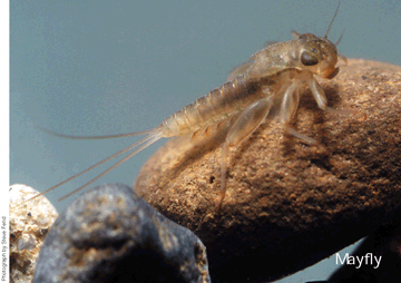
Aquatic invertebrates are indicators of water quality
Aquatic invertebrates are animals such as worms and insects that live in water. Fly fishermen know that game fish such as trout and bass eat insects such as mayflies, stoneflies, and caddisflies. Biologists who study water quality have found that some aquatic invertebrates, such as certain aquatic worms and midges, can tolerate poor water quality. Many types of mayflies, stoneflies, and caddisflies are sensitive to water-quality degradation and are most abundant in streams with good water quality. Biologists can sample for aquatic invertebrates and determine the relative quality of the water by the numbers and types of invertebrates found. |
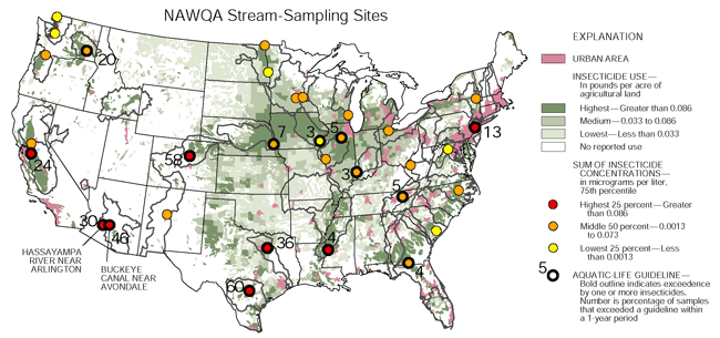
Pesticides in water were measured at 117
sampling sites on 114 rivers and streams across the United States
as part of the NAWQA Program from 1992-1998. At each site, concentrations
of all insecticides detected during a I-year period were summed
and categorized as low (lowest 25 percent), middle (middle 50 percent),
and high (highest 25 percent) compared to concentrations at all
of the sites monitored (see figure below). This information was
compared, by county, to insecticide use during the early to mid-1990's
on agricultural lands.
|

| Table of Contents || Previous Section || Next Section || Glossary U.S. Geological Survey Circular 1213 Suggested citation:
|
