
MAJOR FINDINGS
Urban Development is a Water-Quality Issue Within the Southern Rocky Mountains
Recreation in the mountains of Colorado is becoming a significant land-use activity in many areas. Urban development and the infrastructure to support recreation have increased substantially in the last decade. Between 1990 and 1997, the population increase in Summit and Eagle Counties exceeded 40 percent (http://www.colorado.edu/libraries/govpubs/colonumb/counties.htm). In addition to resident population increases, seasonal population fluxes due to recreation are large. These temporary population increases occur in winter during periods of extreme low flow and minimal dilution in rivers and streams.
Although urban development may be only a small percentage of total watershed area, development and transportation systems tend to be adjacent to riparian areas in mountainous terrain (fig. 6). This land-use pattern has placed human populations in locations that have the greatest effects on the quality of the water resources. Surface- and ground-water studies were implemented to investigate the water-quality issues in urban areas of the Southern Rocky Mountains.
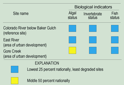
Surface-water studies investigated the effects of urban land use. Two stream-monitoring sites were located in areas of urban development (fig. 6). The Gore Creek site is downstream from Vail, and the East River site is downstream from Crested Butte. Development in Vail is approaching build-out, whereas there is potential for large increases of development in the Crested Butte area. The Colorado River below Baker Gulch, a reference site with little urban development in the Southern Rocky Mountains, was also sampled monthly to provide a comparison with other sites.
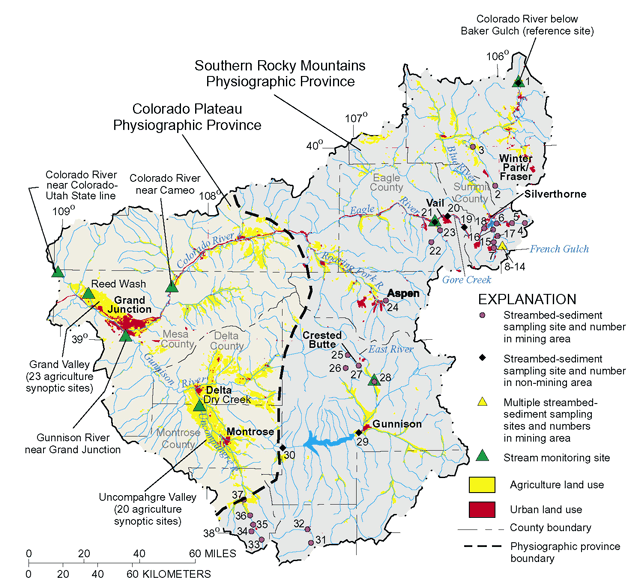 |
| Figure 6. Sampling sites and study areas were selected to assess effects of urban, mining, and agricultural land uses on water quality. |
Nutrient concentrations at sites in areas of urban development were greater than concentrations at the reference site. Concentrations of nitrite plus nitrate and total phosphorus were slightly elevated at Gore Creek and East River compared to reference concentrations (fig. 7). Concentrations for nitrate were below the 10-mg/L Colorado instream standard at all three sites. Un-ionized ammonia concentrations, computed from dissolved ammonia, pH, and temperature, did not exceed State instream standards. Dissolved and orthophosphate phosphorus concentrations were greater at Gore Creek than the other sites. Gore Creek and East River are not wastewater-effluent-dominated streams such as might be found in large metropolitan areas; however, small amounts of nitrogen and phosphorus can increase algal growth and eutrophication processes.
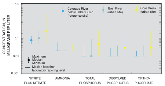 |
| Figure 7. Concentrations of nitrite plus nitrate and total phosphorus were greater at sites with urban development (Gore Creek and East River) than at the reference site (Colorado River below Baker Gulch). Sites shown in order of increasing urban development. A log scale is used due to the large range of concentrations. |
The amount of algae and the types of aquatic invertebrates (insects) are influenced by nutrient enrichment from urban sources. The amount of algae (algal biovolume) determined from algae samples collected in 1996 and 1997 was largest in Gore Creek (fig. 8), where nutrient levels were higher. The percentage of the invertebrate community represented by pollution sensitive insects (mayflies, stoneflies, and caddisflies) was greater at sites with less urban influence (Colorado River below Baker Gulch, fig. 8). The percentage of midges (insects generally tolerant of pollution) increased with increasing urban influence (East River and Gore Creek sites, fig. 8). Even though the percentage of midges was greater at Gore Creek, the invertebrate status of Gore Creek was less degraded than other urban sites in the NAWQA Program (p. 8).
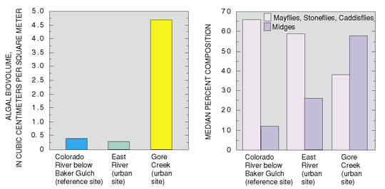 |
| Figure 8. Algal biovolume (the amount of algae) was greater at Gore Creek, which also has greater urban development. The percentage of mayflies, stoneflies, and caddisflies decreased, and the percentage of midges (indicative of more degraded water quality) increased with urban development. Sites shown in order of increasing urban development. |
Nutrient concentrations were generally largest during winter. Concentrations of nitrite plus nitrate and dissolved and total phosphorus were greatest during the late winter low-flow period prior to snowmelt runoff (fig. 9). With the onset of snowmelt runoff, nutrient concentrations were diluted. Algal uptake of nutrients during warm weather (July-October) probably lower concentrations during the summer. With reduced dilution and diminished algal uptake, nutrient concentrations increase again during the winter low-flow period.
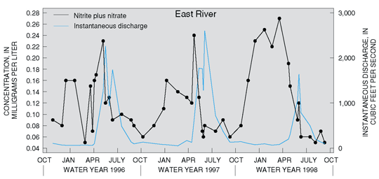 |
| Figure 9. Nutrient concentrations were greatest during the late winter low-flow period prior to peak snowmelt runoff. This pattern was similar for total phosphorus at East River and for nitrite plus nitrate and total phosphorus at Gore Creek. |
Ground-water studies investigated the effects of urban land use on water in selected alluvial aquifers. Although many communities in the UCOL rely on surface water as their primary source of drinking water, a few mountain towns and many thousands of individual homes in the Southern Rocky Mountains use ground water as their primary water source. Effects of urban land use can be indicated by elevated concentrations of nitrate, detections of synthetic organic compounds (pesticides and VOCs), and bacteria.
Ground water was sampled from shallow monitoring wells in the Crested Butte, Gunnison, Silverthorne, Vail, and Winter Park/ Fraser areas (fig. 6). Domestic (household and private) and public supply drinking-water wells of various depths were also sampled in urban areas throughout the Southern Rocky Mountains.
Within the UCOL, there are changes in the algal and invertebrate communities in areas of urban development. Algal biovolume (amount of algae) and midges (insects considered more tolerant of degraded conditions) were greater at sites with urban development than sites with little urban development. However, with the exception of algal status at the Gore Creek site, biological indices for UCOL urban sites are in the lowest 25 percent of urban sites from other NAWQA Study Units. The Gore Creek watershed is more urbanized than the East River watershed, and the changes in the algal community reflect increased nutrient concentrations at this site, making it more typical of other urban sites nationally. The invertebrate and fish communities are ranked among the least degraded nationally at both UCOL urban sites.
Explanation of Biological Rankings |

Some ground-water samples collected in urban areas contained elevated levels of nitrate. Nutrients in ground water can originate from various natural sources (such as atmospheric deposition or dissolution of geologic materials); however, elevated concentrations in ground water are often related to human activities, such as effluent from septic systems or the application of fertilizers. Nitrate concentrations greater than the USEPA Maximum Contaminant Level (MCL) drinking-water standard of 10 mg/L (U.S. Environmental Protection Agency, 1996) were detected in one sample collected from a shallow monitoring well in an urban area but in none of the drinking-water wells. Nutrient concentrations in undeveloped areas (determined from data from the 20 NAWQA Study Units that began in 1991) indicate a national background concentration for nitrate of 2.0 mg/L (U.S. Geological Survey, 1999). The undeveloped areas are considered to be minimally affected by agriculture, urban development, or associated land uses. Twenty percent of the samples collected from monitoring wells (and none of the samples collected from drinking-water wells) contained nitrate concentrations greater than 2.0 mg/L. These findings indicate that portions of the shallow ground-water system have been affected by urban land use, but these effects were not found in the deeper ground water used for drinking water.
Generally, low levels of pesticides and volatile organic compounds were detected in ground water from shallow alluvial aquifers in urban areas. Most agriculture (and pesticide use) in the basin occurs in the Colorado Plateau where ground-water studies were not conducted. The pesticides that were detected in the ground water sampled in the Southern Rocky Mountains were primarily herbicides used for controlling grasses and weeds in nonagricultural areas. Concentrations were very low (less than 0.1 µg/L) for most of the pesticides detected. Two herbicides, bromacil and prometon, were detected in urban areas at concentrations less than the USEPA drinking-water guidelines (U.S. Environmental Protection Agency, 1996).
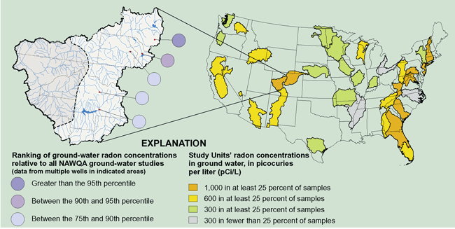
| Radon concentrations in alluvial aquifers of the UCOL are among the highest of all NAWQA ground-water samples nationwide (S.J. Ryker, USGS, written commun., 1999). Radon is a naturally occurring, colorless, odorless, radioactive gas derived from the decay of uranium. Radon has been identified as a human carcinogen and can enter a building from seepage of air through dirt floors, cracks in concrete floors or walls, floor drains, or through the use of water supplied from wells. A greater risk of exposure to radon exists in urban areas due to the prevalence of enclosed structures, such as basements, which can trap radon gas. Though the USEPA does not currently (2000) regulate radon in drinking water, there is a proposed maximum contaminant level (MCL) of 300 picocuries per liter (pCi/L) for radon in drinking water (U.S. Environmental Protection Agency, 1999). Radon concentrations were greater than the proposed MCL for all wells sampled in the Southern Rocky Mountains. Higher radon concentrations were measured in the Winter Park/Fraser and Silverthorne areas. Igneous and metamorphic rocks, which can contain uranium-bearing minerals, are common rock types in these areas.
|

Volatile organic compounds (VOCs) were detected in ground-water samples at generally low concentrations. The six most frequently detected VOCs were methyl tert-butyl ether (MTBE), tetrachloroethene, chloroform, 1,1,1-trichloroethane, 1,2,4-tri-methylbenzene, and dichloro-methane (fig. 10). MTBE, a gasoline additive, was detected in at least one well in four of the five urban areas where shallow ground water was sampled. In addition, MTBE was detected in water from one municipal well. MTBE concentrations greater than the drinking-water lifetime health advisory of 2040 µg/L (U.S. Environmental Protection Agency, 1997) were not detected. However, once MTBE enters the ground water, it is less vulnerable to decomposition and travels farther than other gasoline compounds (Squillace and others, 1996).
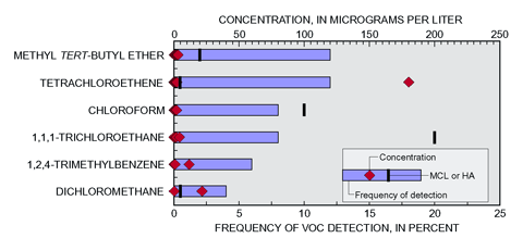 |
| Figure 10. Volatile organic compounds were detected at low frequencies in monitoring and drinking-water wells sampled in the Southern Rocky Mountains. With a few exceptions (2 samples), concentrations of VOCs were substantially less than water-quality standards. All concentrations shown are greater than 0 mg/L. (MCL, maximum contaminant level; HA, health advisory.) |
Tetrachloroethene is present in solvents for adhesives and is also a by-product of dry cleaning. Chloroform can occur naturally or result from the chlorination of drinking water. 1,1,1-Trichloroethane is present in solvents and cleaning agents. 1,2,4-Trimethylbenzene is present in petroleum by-products. Dichloromethane is predominantly used as a solvent in paint strippers and removers. Concentrations of dichloromethane and tetrachloro-ethene were greater than the USEPA drinking-water standard of 5 µg/L at one site in Silverthorne.
Total coliform bacteria were detected in 21 percent of the ground-water samples collected in urban areas. Total coliform bacteria were detected only in samples collected from the shallow monitoring wells and in none of the water samples from drinking-water wells. Bacteria in ground water may occur naturally in soils or may be related to human or animal waste and, therefore, may be an indication of the sanitary quality of the water (Myers and Sylvester, 1997). However, the presence of total coliform bacteria does not necessarily indicate the presence of potentially pathogenic bacteria such as Escherichia coli (E. coli), which was not detected in any of the samples.
| Chlorofluorocarbons (CFCs) were used to determine the age of ground water Shallow ground water, which is used for drinking water in part of the Southern Rocky Mountains, is generally young (less than 10 years old) and is more susceptible to contamination as a result of land-use practices. The age of the ground water refers to the time from when the water recharged, or entered, the aquifer to the time it was withdrawn from the aquifer. The presence of contaminants, if any, in ground water can reflect land-use conditions at the time of recharge. The age of the ground water was determined in five urban areas where water-quality samples were collected from shallow alluvial aquifers. The age of ground water at most of the sites sampled ranged from 0 to 10 years old. Ground-water ages of greater than 10 years were found in 7 of 25 wells. In the samples where CFC dates were obtained, four of the five nitrate concentrations greater than 2.0 mg/L were from recently recharged ground water (10 years or younger). This is an indication that current land use may be affecting water quality. Increasing urban development may add nitrate to the ground water from different sources, such as septic systems, application of fertilizers, and domestic animal wastes. Effects of increased urban development on ground-water resources are not extensive in the study area at present. |
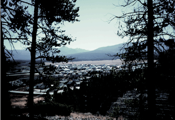 |
| Urban land use in the Southern Rocky Mountains, near Fraser, Colorado. (Photograph by Jeffrey B. Bails, U.S. Geological Survey.) |
The Quality of Streams and Rivers is Affected by Historical Mining Activities
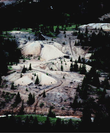 |
| Mining land use in the Southern Rocky Mountains. (Photograph by Jeffrey Deacon, U.S. Geological Survey. |
Streams affected by mine drainage, from abandoned/inactive mines, are present throughout much of the Rocky Mountains of Colorado. Metal mining in the UCOL has been an important part of the economy of Colorado since the late 1800s. As a result, many streams in the upper part of the basin contain heavy metals and other toxic elements that affect stream-water quality. Knowledge of mine-drainage effects on a body of water is essential for assessing water quality with regard to human consumption, recreation, and aquatic life.
Because of the potential exposure of aquatic organisms to trace elements in streambed sediment, trace-element concentrations in streambed sediment serve as an indicator of potential toxicity to aquatic life. Sampling trace elements in streambed sediment can be used to identify stream reaches affected by mining and can be used to determine sources of trace elements. The occurrence and distribution of trace elements were characterized by collecting streambed-sediment samples at 29 sites in mining districts (fig. 6 and table 1) and at 8 background (non-mining) sites in the Southern Rocky Mountains.
|
Table 1. Mining districts and sampling sites in the Southern Rocky Mountains |
|
|
Mining district1 |
River/Stream [site number(s) in figure 6]2 |
|---|---|
|
Aspen |
Hunter Creek (24) |
|
Breckenridge |
Blue River, French Gulch, Swan River (7, 10, 11, 12, 13, 14, 15, 16, 17) |
|
Climax |
Tenmile Creek (18) |
|
Crested Butte |
Oh-Be-Joyful Creek, Coal Creek, Slate, East Rivers (25, 26, 27, 28) |
|
Gilman |
Cross Creek, Eagle River (22, 23) |
|
Lake City (Carson, Burrows, Sherman Districts) |
Lake Fork of the Gunnison River, Hensen Creek (31, 32) |
|
Montezuma |
Peru Creek, Snake River (4, 5, 6) |
|
Ouray (Red Mountain, Sneffels, Uncompahgre Districts) |
Canyon Creek, Red Mountain Creek, Uncompahgre River (33, 34, 35, 36, 37) |
|
Urad-Henderson |
South Fork of Williams
Fork, |
| 1
Information from Davis and Streufert (1990). |
|
Concentrations of cadmium, copper, lead, and zinc in streambed sediment were high at some sites downstream from mining areas (Deacon and Driver, 1999). Median concentrations of cadmium (Cd) and zinc (Zn) in samples from most mining districts exceeded the Canadian Sediment Quality Guidelines Probable Effect Level (PEL), which is a sediment guideline (fig. 11). The PEL defines the concentration level above which adverse effects to aquatic biota are predicted to occur frequently (Canadian Council of Ministers of the Environment, 1999). National sediment concentration guidelines have not been established for the United States. Concentrations of copper and lead were also elevated and exceeded the PEL in several mining districts. The mining and mineralized areas of the UCOL generally result in higher trace-element concentrations in streambed sediment than are detected in other areas studied within the NAWQA Program (p. 12).
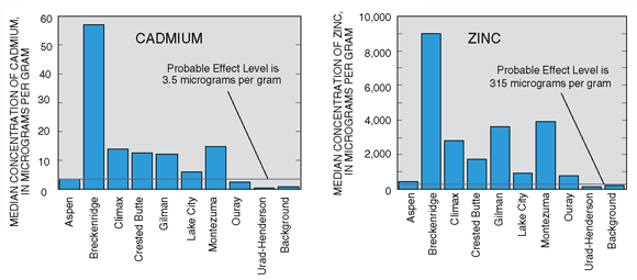 |
| Figure 11. Median concentrations of cadmium and zinc in streambed sediments were greater than the Canadian Probable Effect Level in most mining districts of the UCOL. |
Collecting samples from several types of media provides a better understanding of trace elements in the environment. In addition to streambed sediment, which can store trace elements, the overlying stream water can also be a source of trace-element exposure to aquatic organisms. Because invertebrates are continuously exposed to water-quality conditions, these organisms integrate effects of contaminants over time and provide a measurement of water quality. Invertebrate indicators of streams contaminated by trace elements include reduced abundance and a shift in community composition from sensitive insects, such as mayflies, to more tolerant insects, such as midges. Lower mayfly abundance can be related to increased trace-element concentrations (Clements and Kiffney, 1995; Clements, 1994; Kiffney and Clements, 1994). Concentrations of trace elements in transplanted aquatic moss also provide information about the occurrence and bioavailability of trace elements (Carter and Porter, 1997). In order to assess the source(s) and environmental effects of trace elements, a more detailed study was conducted in the Blue River Basin; this study included the collection of water, streambed sediments, reservoir sediments, and aquatic moss samples and an assessment of the habitat and invertebrate communities.
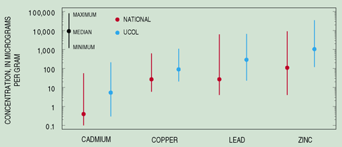
The median concentrations for cadmium, copper, lead, and zinc in streambed sediment from sites in the UCOL were higher than the median concentrations of the same trace elements sampled in other Study Units of the national NAWQA Program. The data available on trace elements include 541 samples from the NAWQA Study Units (Rice, 1999) and 37 samples from the UCOL. Mineralized areas and historical mining activities in the UCOL have resulted in higher concentrations of some trace elements in streams than those concentrations that typically are found in other parts of the United States. |

Mining activities have affected trace-element concentrations and aquatic invertebrates in French Gulch and the Blue River. Samples from different media were used to investigate the effects of mining activities on the water quality and associated biota at 10 sites along the Blue River and French Gulch, a tributary of the Blue River (fig. 12). Sites 2 and 3 (fig. 12) are background sites on French Gulch and are minimally affected by mining activities. Zinc concentrations in water and streambed sediment and zinc accumulated by aquatic moss at these background sites were lower than those from sites downstream from the mined areas. The invertebrate community structure (as indicated by mayfly abundance and percent midges) was minimally affected at the background sites.
 |
| Collecting sediment core samples on Dillon Reservoir. (Photograph by Norman Spahr, U.S. Geological Survey.) |
Although habitat conditions at site 4 were degraded and zinc concentrations were greater than those upstream, the invertebrate community was not found to be significantly degraded. Farther down-stream, where underground mine seepage contributes to surface runoff (site 6), zinc concentrations in the water, streambed sediment, and aquatic moss were high and the invertebrate communities were degraded. The most affected site along French Gulch was site 7, located near the confluence with the Blue River.
Site 1, upstream from French Gulch on the Blue River, was characterized by lower zinc concentrations in water, moss, and sediment than downstream sites, indicating that the French Gulch basin is contributing zinc to the Blue River. Downstream from the confluence of French Gulch with the Blue River (site 8), concentrations of zinc in water, moss, and streambed sediment were higher than background levels but slightly lower than in French Gulch. Also at site 8, brown trout livers had the highest concentrations of zinc of any sites sampled in the Southern Rocky Mountains (Deacon and Stephens, 1998). The invertebrate community in the Blue River downstream from French Gulch was degraded (site 8). The site conditions remain moderately affected downstream to Dillon Reservoir (site 10).
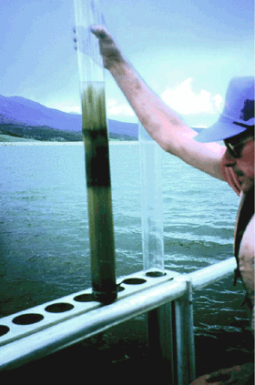 |
| Sediment core from Dillon Reservoir. (Photograph by Norman Spahr, U.S. Geological Survey.) |
Mining activities have affected trace-element concentrations in the bottom sediment of Dillon Reservoir. Dillon Reservoir was constructed in 1963 in an area with a long history of mining activity. Sources of trace elements in Dillon Reservoir, a drinking-water supply for the city of Denver, are located in the Blue River, Snake River, and Tenmile Creek Basins. The reservoir is accumulating some trace elements. For example, loads calculated using streamflow and water concentration indicate that only 37 percent of the zinc that enters Dillon Reservoir leaves the reservoir (fig. 12, top left graph).
Sediment cores were collected at several locations in Dillon Reservoir. Concentrations of lead and zinc throughout the core collected near the dam exceeded the PEL. Cadmium, lead, and zinc concentrations in sediment cores from the Blue River, Snake River, and Tenmile Creek arms of the reservoir also were above the PEL (values for zinc are shown in the top of fig. 12).
Although bottom sediment concentrations of some trace elements exceeded the PEL, concentrations in the water column were not high. The concentrations of trace elements in the reservoir water column did not exceed the Colorado surface-water-quality standards.
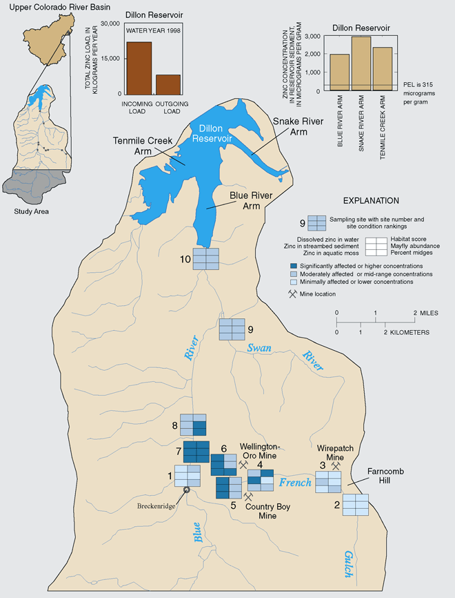 |
| Figure 12. Different types of sampling media provide a better understanding of conditions at sites sampled in the Blue River Basin. Dillon Reservoir sediments are accumulating some trace elements originating from mining areas. |
| Table of Contents || Previous Section || Next Section || Glossary U.S. Geological Survey Circular 1214 Suggested citation:
|
