
MAJOR FINDINGS—Continued
| Selenium in Western Colorado
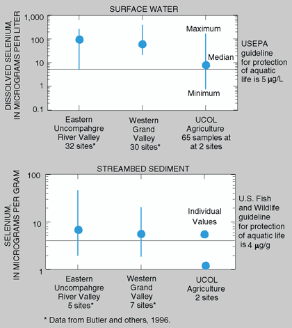
Selenium, a naturally occurring trace element, is common throughout the Western United States in marine sedimentary rocks. It is an essential micronutrient for birds, fish, and animals (Mayland, 1994) but at high concentrations can be highly toxic to fish and wildlife. Selenium can be very mobile in the environment and the mobility can be accelerated by irrigation. As irrigation water is applied to soils containing selenium, the selenium is leached out of the soils and into surface and ground water. Selenium in wetlands, ponds, and lakes is incorporated into bed sediment and can be bioaccumulated by wildlife, including fish and birds (Ohlendorf and others, 1986). Areas of the Western United States susceptible to selenium contamination from irrigation, which include the Grand and Uncompahgre Valleys in western Colorado, have been identified by Seiler and others (1999). Extensive irrigated agriculture is present in the Grand and Uncompahgre Valleys of the Colorado Plateau in western Colorado (fig. 6). Irrigation drainage from these areas may account for as much as 75 percent of the selenium load in the Colorado River near the Colorado-Utah State line (Butler and others, 1996). It is estimated that 61 percent of the selenium load to Lake Powell in Utah originates from these agricultural areas in the UCOL (Engberg, 1999). Primary source areas of selenium in western Colorado are the western one-half of the Grand Valley and the eastern side of the Uncompahgre River Valley where the residual soils and alluvium are derived primarily from the Mancos Shale, a marine shale containing selenium. A study in 199193 of irrigation drainage in the Grand and Uncompahgre River Valleys detected relatively high concentrations of selenium in many surface-water and streambed-sediment samples (Butler and others, 1996). Concentrations of selenium greater than the aquatic-life guidelines were also detected in the UCOL surface-water sampling in agricultural areas during 199598 and at one streambed-sediment sampling site in 1995. Investigations of selenium in western Colorado for remediation planning are continuing through the U.S. Department of the Interior National Irrigation Water Quality Program and the Gunnison Basin Selenium Task Force. |
Water-Quality Characteristics of Agricultural Areas
Agricultural land use constitutes about 5 percent of the Study Unit area (fig. 6). Within the Southern Rocky Mountains, agricultural land is almost exclusively hay meadows. The agricultural areas of the Colorado Plateau (principally the Grand Valley near Grand Junction in Mesa County and the Uncompahgre Valley near Delta and Montrose in Delta and Montrose Counties, fig. 6) produce hay, corn, small grains, dry beans, onions, melons, fruit, and grapes. The Grand Valley has about 70,000 acres of irrigated land, and the Uncompahgre Valley contains about 86,000 irrigated acres (Butler and others, 1996). The market value of agricultural products produced in Delta, Mesa, and Montrose Counties was about 145 million dollars in 1992 (Bureau of the Census, 1994). Pesticides, nutrients, and sediment are water-quality issues commonly associated with agricultural land use.
Pesticides were sampled in different media. Pesticides were investigated in surface water by periodic monitoring at 2 agricultural sites and a one-time synoptic sampling at 43 agricultural sites. Fish were collected once at three agricultural sites and the tissues analyzed for organochlorine pesticides. Organochlorine pesticides in streambed sediments were sampled once at six agricultural sites. Ground-water samples were not collected in the agricultural areas of the UCOL because ground water is generally not used for public water supply in these areas.
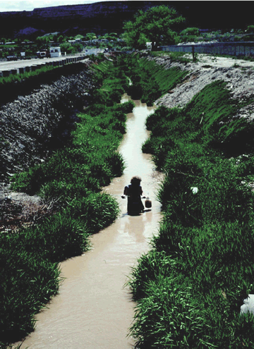 |
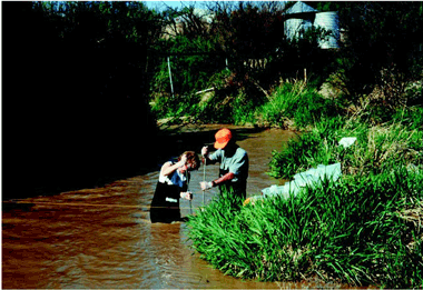
| Collecting water samples at an agricultural drain in the Grand Valley. (Photograph by Norman Spahr, U.S. Geological Survey.) |
Pesticides were commonly detected in agricultural areas of the UCOL, but concentrations were generally low. Most pesticide detections in surface water were not at concentrations of concern. Freshwater aquatic-life guidelines were exceeded occasionally; however, guidelines have not been established for all compounds. Only 5 of the 90 samples collected in the agricultural areas contained pesticides that exceeded established guidelines. The pesticides that exceeded guidelines for protection of freshwater aquatic life are azinphos-methyl, 1 of 24 samples at Reed Wash; carbaryl, 2 synoptic sites, Indian Wash and Orchard Mesa Drain in the Grand Valley; diazinon, 1 synoptic site, Indian Wash; diuron, 1 synoptic site, Indian Wash; and gamma- HCH, 1 synoptic site, the drain at Blossom Road in the Uncompahgre Valley.
Pesticide detections and concentrations showed seasonal patterns. Periodic sampling at two agricultural streams showed that the total number of pesticides detected was greatest during April through August (Bauch and Spahr, 2000). Pesticide detections per month for Dry Creek are shown in figure 13. Concentrations of atrazine were found to be greater from May through August than during other periods of the year (fig. 13). The seasonal pattern of concentrations was similar for other pesticides and reflects the growing season for the Grand and Uncompahgre Valleys.
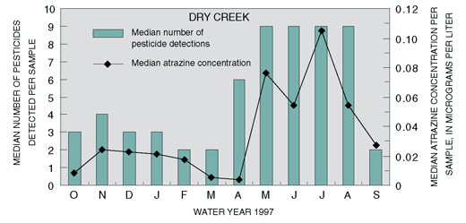 |
| Figure 13. The number of pesticide detections and median atrazine concentrations in surface water are greater during the spring and summer months. Atrazine is commonly used for season-long weed control in corn. |
Pesticides were detected in 40 of 43 agricultural streams. Thirty-one pesticides (21 herbicides and 10 insecticides) were detected at least once during a May 1998 agricultural stream synoptic study in the Grand Valley and Uncompahgre Valley areas. Atrazine and alachlor were detected in more than 50 percent of the samples. Concentrations of atrazine did not exceed aquatic-life guidelines. Guidelines are not available for alachlor.
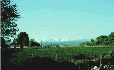 |
| Agriculture and the San Juan Mountains near Montrose. (Photograph by Norman Spahr, U.S. Geological Survey.) |
Some insecticides have persisted in streambed sediment and fish tissue, although their use has been banned or restricted. DDT was banned in 1972, but DDT or its breakdown products, DDE and DDD, were detected in streambed sediments at five of the six agricultural sites sampled and in fish tissue at all three of the agricultural sites where fish tissue samples were collected (Stephens and Deacon, 1998). Concentrations of DDT and DDE in streambed sediment at two sites exceeded the Canadian Sediment Quality Guidelines PEL (Canadian Council of Ministers of the Environment, 1999). The DDD concentration at one site exceeded the PEL. Dieldrin (a restricted use insecticide since 1974) was detected in stream-bed sediments at two of the six sites and in fish tissue at all three sites. Insecticides detected in fish tissue and streambed sediments were generally not detected in water samples from the same site, probably because these compounds are relatively insoluble in water. Occurrence of organochlorine pesticides, even at low concentrations, is becoming increasingly relevant because of recent evidence linking these compounds to endocrine disruption (Goodbred and others, 1997).
| The three most commonly detected herbicides at the two agricultural monitoring sites in the UCOL (one site each in the Grand and Uncompahgre Valleys) also were among the top 10 herbicides detected in surface-water samples at 62 agricultural sites in 35 nationally distributed NAWQA Study Units. The percentages of samples with detections for atrazine, alachlor, and metolachlor are shown below and are based on more than 1,550 samples for the national sites and 39 samples at the UCOL sites. Atrazine, alachlor, and metolachlor are commonly used for weed control in corn. Alachlor and metolachlor are also used for weed control in dry beans. Other herbicides that were frequently detected (present in over one-third of the samples) in the UCOL but not shown in the graph include trifluralin, DCPA, 2,4-D, cyanazine, and deethylatrazine (a breakdown product of atrazine). These herbicides also were commonly detected at other agricultural sites across the Nation. Median concentrations of the commonly detected herbicides in the UCOL were less than or similar to the median concentrations for the national sites. Concentrations of atrazine and metolachlor were less than the Canadian guidelines for the protection of aquatic life [1.8 µg/L for atrazine and 7.8 µg/L for metolachlor (Environment Canada, 1999)]. Guidelines have not been established for alachlor.
|

![The three most commonly detected herbicides at the two agricultural monitoring sites in the UCOL (one site each in the Grand and Uncompahgre Valleys) also were among the top 10 herbicides detected in surface-water samples at 62 agricultural sites in 35 nationally distributed NAWQA Study Units. The percentages of samples with detections for atrazine, alachlor, and metolachlor are shown below and are based on more than 1,550 samples for the national sites and 39 samples at the UCOL sites. Atrazine, alachlor, and metolachlor are commonly used for weed control in corn. Alachlor and metolachlor are also used for weed control in dry beans. Other herbicides that were frequently detected (present in over one-third of the samples) in the UCOL but not shown in the graph include trifluralin, DCPA, 2,4-D, cyanazine, and deethylatrazine (a breakdown product of atrazine). These herbicides also were commonly detected at other agricultural sites across the Nation. Median concentrations of the commonly detected herbicides in the UCOL were less than or similar to the median concentrations for the national sites. Concentrations of atrazine and metolachlor were less than the Canadian guidelines for the protection of aquatic life [1.8 µg/L for atrazine and 7.8 µg/L for metolachlor (Environment Canada, 1999)]. Guidelines have not been established for alachlor.](images/ucrb_fig13a.gif)
Nutrient concentrations in streams and rivers reflect point and nonpoint sources. National background concentrations have been determined for some forms of nutrients: total nitrogen in streams (1.0 mg/L), nitrate in streams (0.6 mg/L), and total phosphorus in streams (0.1 mg/L) (U.S. Geological Survey, 1999). Relative concentrations of nutrients in surface water are linked to the amounts and types of substances used and discharged in different land-use settings. These substances can then reach the stream through point sources (such as wastewater discharge) or nonpoint sources (such as precipitation or runoff from agricultural areas). Estimated amounts of fertilizer applied during 1997 in Delta, Mesa, and Montrose Counties were about 14,100,000 pounds of nitrogen and 1,800,000 pounds of phosphorus (Jeffrey Stoner, U.S. Geological Survey, written commun., 2000). Fertilizer use in these counties accounted for about 77 percent of the total estimated fertilizer usage for the UCOL.
Nutrient concentrations in areas of agricultural land use were generally greater than in areas of other land uses. Median concentrations of ammonia, nitrite plus nitrate, total phosphorus, dissolved phosphorus, and orthophosphate were greater at agriculture sites than at the Colorado Plateau reference and mixed land-use sites (fig. 14). The Colorado Plateau reference site has some limited agriculture upstream (livestock/hay meadows), so is not representative of natural conditions but is probably representative of small streams in the Colorado Plateau. Median concentrations of nutrients at agricultural sites also were greater than median concentrations at mixed land-use and urban sites within the Southern Rocky Mountains. The urban areas shown in the bar chart are downstream from Vail and Crested Butte, Colorado (fig. 6), and are streams that are not dominated by wastewater effluent such as might be found in large metropolitan areas. Concentrations of nitrite and nitrate were within State standards for agricultural water use. Water from the agricultural streams is not commonly used for domestic supply.
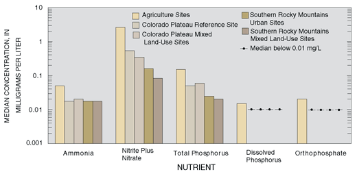 |
| Figure 14. Concentrations of nutrients in agricultural areas of the UCOL were greater than concentrations in other land-use settings. A log scale is used due to the large range of concentrations. |
Geology and agriculture contribute to elevated suspended-sediment concentrations in the Colorado Plateau. Suspended-sediment concentrations in the streams and rivers of the Colorado Plateau were much greater than concentrations in the Southern Rocky Mountains (fig. 15), due in large part to differences between the sedimentary geology of the Colorado Plateau and the igneous-metamorphic geology of the Southern Rocky Mountains. Agricultural return flows also contribute to the greater sediment concentrations measured at the agricultural sites.
The reference site in the Colorado Plateau also had elevated sediment concentrations. Any rain or snowmelt event in these areas tends to substantially increase the sediment concentrations of streams and rivers because of the high erodibility of the soils.
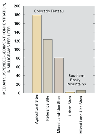 |
| Figure 15. Suspended-sediment concentrations were greatest in the agricultural areas of the Colorado Plateau. |
 |
| Sediment and water-quality sampling at Reed Wash. (Photograph by Norman Spahr, U.S. Geological Survey.) |
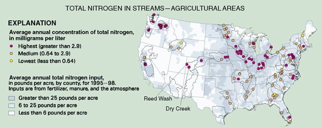
| Total nitrogen (the sum of nitrite, nitrate, ammonia, and organic nitrogen) concentrations at the UCOL agricultural monitoring sites (Reed Wash and Dry Creek) were ranked in the group of national agricultural sites with the highest concentrations. The map below shows a comparison of average annual total nitrogen concentrations at the two UCOL agricultural sites with agricultural sites in other NAWQA Study Units. The average concentrations for the UCOL sites were 3.8 milligrams per liter for Reed Wash and 3.2 milligrams per liter for Dry Creek and are less than State instream standards. Average annual total phosphorus concentrations at the two agricultural sites in the UCOL also ranked among the group of national agricultural sites with the highest total phosphorus concentrations.
|

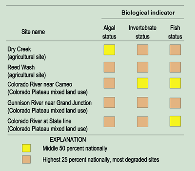
The elevated nutrient and sediment concentrations found in the agricultural and surrounding areas of the Colorado Plateau help to explain the prevalence of more tolerant biological species. Algal, invertebrate, and fish communities in the Colorado Plateau generally consist of species more tolerant to nutrients and sediments. These result in higher degradation rankings for all three biological measures. The biological measures in the Colorado Plateau indicate that agricultural and mixed land-use sites in the UCOL are above the national average in terms of degradation. These rankings compare UCOL agricultural sites to other NAWQA agricultural sites and UCOL mixed land-use sites to other NAWQA mixed land-use sites nationally.
Explanation of Biological Rankings The three selected biological indicators respond to changes in stream degradation. Degradation can result from a variety of factors that modify habitat or other environmental features such as land use, water chemistry, and flow. Algal status focuses on the changes in the percentage of certain algae in response to increasing siltation and often is positively correlated with higher nutrient concentrations in many regions of the Nation. Invertebrate status is the average of 11 invertebrate metrics that summarize changes in richness, tolerance, trophic conditions, and dominance associated with water-quality degradation. Fish status focuses on changes in the percentage of tolerant fish species that make up the total number of fish. "Tolerant" fish are reported to thrive in degraded water quality. For all indicators, higher values indicate degraded water quality.
|

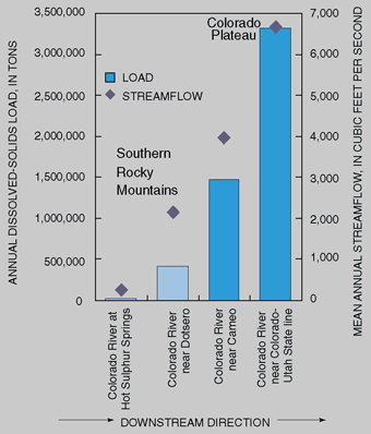
| Salinity in the Colorado River Basin A serious water-quality issue in the Colorado River Basin is salinity defined as the concentration of dissolved mineral salts or total dissolved solids in water. Salinity increases in the Colorado River in a downstream direction; the dissolved-solids concentration is about 50 mg/L in the upstream mountain areas and averages about 850 mg/L at Imperial Dam, Arizona (Kircher, 1984). In the UCOL, annual dissolved-solids loads in the Colorado River ranged from about 17,700 tons at Hot Sulphur Springs in the Southern Rocky Mountains to more than 3,300,000 tons near the Colorado-Utah State line.
Major sources of salinity in the Colorado River Basin are mineral springs and nonpoint-source runoff. The major human influence is irrigated agriculture. About 11 percent of the salt load in the Colorado River near the U.S.Mexico border is contributed from the Grand Valley and Uncompahgre Valley (lower Gunnison River Basin) agricultural areas (U.S. Department of the Interior, 1999). Much of the soil in these areas is derived from and overlies the Mancos Shale, a saline marine deposit. Deep percolation of irrigation water and seepage losses from irrigation systems leach salt from the soil and shale, increasing the salinity of return flows. Salinity-control projects have been constructed throughout the Colorado River Basin, including two projects in the UCOLthe Grand Valley Unit and the Lower Gunnison Basin Unit. As part of the study of salinity in the Colorado River Basin, trends in dissolved-solids concentrations in the basin have been investigated in numerous studies (Vaill and Butler, 1999; Bauch and Spahr, 1998; Butler, 1996; Liebermann and others, 1989; Kircher, 1984). The most recent study (Vaill and Butler, 1999) determined that since the 1960s there have been, in general, downward trends in flow-adjusted annual and monthly dissolved-solids concentrations and loads in the Colorado River Basin upstream from Lake Powell in Utah, except in the Yampa River Basin. In the UCOL, there were downward trends both upstream and downstream from the salinity-control projects in the Grand Valley and the lower Gunnison River Basin. With the downward trends as evidence, it appears that both natural processes and human efforts such as salinity-control projects may be decreasing salinity loading in the Colorado River Basin. |
| Table of Contents || Previous Section || Next Section || Glossary U.S. Geological Survey Circular 1214 Suggested citation:
|
