STUDY UNIT DESIGN
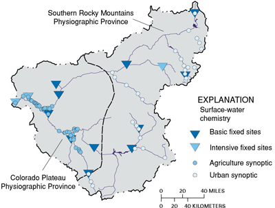
| SURFACE-WATER CHEMISTRY The basic fixed site network was established to investigate the differences in stream-water quality associated with land use and environmental settings within the UCOL. Basic fixed sites were sampled monthly to determine temporal variability of water-quality constituents. The three intensive fixed sites (a subset of the basic fixed site network) were sampled weekly to monthly to further define temporal variability. Synoptic studies were designed to investigate agriculture and urban development effects on water quality. Synoptic sites were sampled one or two times to determine spatial influences of land use on water chemistry. |
 |
|
|
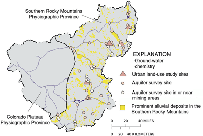
GROUND-WATER CHEMISTRY To evaluate the effects of urban land use on shallow ground-water quality, five areas within the Southern Rocky Mountains that are undergoing urban development and use ground water as a primary drinking-water source, were studied. An overall assessment of water quality in predominantly alluvial aquifers of the Southern Rocky Mountains was also completed. In addition to the overall assessment, wells were selected in or near mining areas. Alluvial aquifers were selected for these studies because they are generally productive and can be susceptible to land-use practices. |
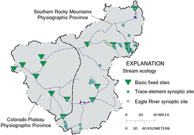
| STREAM ECOLOGY Ecological assessments were done at all basic fixed sites plus one additional site on the Blue River. A synoptic study in mining areas of the Southern Rocky Mountains investigated trace elements in streambed sediment, aquatic moss, and surface water. A characterization of the algal and invertebrate communities and nutrient concentrations in surface water was completed at five sites on the Eagle River. |
 |
| SUMMARY OF DATA COLLECTION IN THE UPPER COLORADO RIVER BASIN, 1996-98
|
||||
|
Study |
What data were collected and why |
Types of sites sampled |
Number of sites |
Sampling frequency and period |
|---|---|---|---|---|
|
Surface-Water Chemistry |
||||
| Basic fixed sites-general water chemistry |
Monthly samples collected for major ions, nutrients, organic carbon, and suspended sediment to describe concentration variability and loads. Daily streamflow also collected or computed. |
Streams and rivers representing urban development, mining, agricultural, and mixed land use. |
14 |
Monthly plus additional high- or low-flow samples for water years 1996-98 |
| Intensive fixed sites |
All constituents collected for the fixed sites. Weekly to monthly samples collected to describe temporal variability in pesticide and volatile organic compounds concentrations. |
A subset of the fixed site network. One site representing urban development, one site representing agricultural land use, and the outlet of the Study Unit. |
3 |
Weekly to monthly plus additional high- or low-flow samples for water year 1997 |
| Synoptic sites-agriculture |
One time sample to describe the spatial variability of pesticides and nutrients in agricultural areas. |
Agricultural drains, streams and rivers in the Grand and Uncompahgre Valleys. Outlet of the Study Unit. |
43 |
May 1998 |
| Synoptic sites-urban development |
Nutrient and algae samples along an upstream to downstream profile in areas of urban development to investigate influences of urban development. |
Upstream to downstream sites along seven tributary rivers. |
30 |
March and September 1998 |
| Ground-Water Chemistry |
||||
| Land-use effects-Urban |
Samples collected for major ions, nutrients, 18 trace elements,
radon, dissolved organic carbon, 87 pesticides, |
Shallow monitoring wells |
25 |
Spring and Fall 1997 |
|
Aquifer |
Samples collected for major ions, nutrients, 18 trace elements, radon, dissolved organic carbon, 47 pesticides, 86 volatile organic compounds, and bacteria (total coliform and E. coli) to describe the water-quality conditions in selected alluvial aquifers throughout the Southern Rocky Mountains Physiographic Province. |
Private and municipal drinking-water wells
|
28 |
Once in 1997 |
|
Aquifer |
Samples collected for same as above (except that 13 of these sites were not sampled for pesticides or volatile organic compounds) to describe the water-quality conditions in selected alluvial aquifers throughout the Southern Rocky Mountains Physiographic Province for wells located in or near mining areas. |
Private and municipal drinking-water wells
|
14 |
Once in 1997 |
| Stream Ecology |
||||
| Basic fixed sites |
Fish, invertebrate, and algae communities, trace elements, and organics in streambed sediment and fish tissue, and habitat data were collected to assess the occurrence and distribution within the UCOL. |
Streams and rivers representing urban development, mining, agricultural, and mixed land use.
|
15 |
Fish community, invertebrate community, and algae August, 1996-98; |
| Synoptic sites-trace elements |
Trace-element concentrations in streambed sediment, aquatic moss, and water; and invertebrate community structure to assess the spatial extent and magnitude of trace-element contamination from mining areas. |
Areas of mining land use and background sites in areas of no mining. |
32 |
August 1998 |
| Synoptic sites-Eagle River |
Invertebrates, algae, and nutrients in water to characterize current conditions in an area of extensive urban development. |
Sites within and downstream from developed areas. Additional sites in areas that may be developed in the future. |
5 |
February and September 1997 |
| Table of Contents || Previous Section || Next Section || Glossary U.S. Geological Survey Circular 1214 Suggested citation:
|


