
INTRODUCTION TO THE PUGET SOUND BASIN
The Puget Sound Basin encompasses the 13,700-square-mile area that drains to Puget Sound and adjacent marine waters. Included are all or part of 13 counties in western Washington, as well as the headwaters of the Skagit River and part of the Nooksack River in British Columbia, Canada. Streams and rivers drain three physiographic provincesthe Olympic Mountains in the west, the Cascade Range in the east, and the Puget Lowlands in the center of the basin (fig. 1).
 |
||
| Figure 1. Streams and rivers drain three physiographic provinces in the Puget Sound Basin (Black and Silkey, 1998). |
Land Use Affects Water Quality and Stream Habitat
Nearly 4 million people, or about 70 percent of Washington States population, live in the Puget Sound Basin. Urban growth is rapid; by 2020, the population is expected to increase by 1.1 million people, with most growth in urban and suburban areas. Urban and agricultural land uses, which cover about 9 and 6 percent of the basin, respectively (fig. 2), are concentrated in the lowlands. Forest dominates land use and cover in the basin and is concentrated in the foothills and mountains (see map, p. 1).
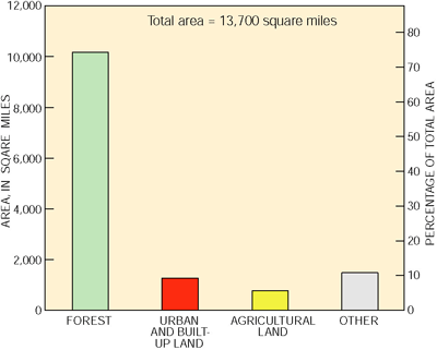 |
| Figure 2. Land use and cover in the basin is predominantly forest. |
The quality of water and aquatic biota has been affected by a range of forestry, agricultural, and urban development practices. The chemical quality of surface water in the foothills and mountains is generally suitable for most uses. However, the physical hydrology, water temperature, and biologic integrity of streams have been influenced to varying degrees by logging (Black and Silkey, 1998). The quality of ground water in the upper watersheds probably differs little from natural conditions.
Because of development, many streams in the Puget Lowlands have undergone changes in structure and function with a trend toward simplification of stream channels and loss of habitat (Black and Silkey, 1998). Sources of contaminants to lowland streams and lower reaches of large rivers are largely nonpoint because most major point sources discharge directly to Puget Sound. Compared with that in small streams in the Puget Lowlands, the quality of water in the lower reaches of large rivers is better because much of the flow is derived from the forested headwaters.
More than half of the agricultural acreage in the basin is located in Whatcom, Skagit, and Snohomish Counties. Agricultural land use consists of about 60 percent cropland and 40 percent pasture. Livestock produce a large amount of manure that is applied as fertilizer to cropland, sometimes in excess amounts, resulting in runoff of nitrogen and phosphorus to surface water and leaching of nitrate to ground water. Runoff from agricultural areas also carries sediment, pesticides, and bacteria to streams (Staubitz and others, 1997). Pesticides and fumigant-related compounds are present, usually at low concentrations, in shallow ground water in agricultural areas.
Heavy industry is generally located on the shores of the urban bays and along the lower reaches of their influent tributaries, such as Commencement Bay and the Puyallup River in Tacoma and Elliott Bay and the Duwamish Waterway in Seattle. High-density commercial and residential development occurs primarily within and adjacent to the major cities. Development in recent years has continued around the periphery of these urban areas but has trended toward lower density. This trend has resulted in increasing urban sprawl in the central Puget Sound Basin (fig. 3).
Urban land-use activities have had a significant impact on the quality of streams in the Puget Sound Basin (Staubitz and others, 1997). Water-quality concerns related to urban development include providing adequate sewage treatment and disposal, transport of contaminants to streams by storm runoff, and preservation of stream corridors.
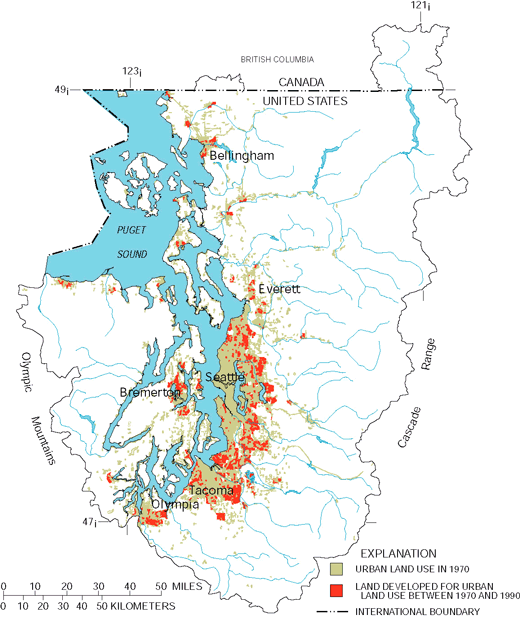 |
||
| Figure 3. Recent urban development in the Puget Sound Basin has been around the periphery of established urban areas. |
Water Availability Is a Major Issue
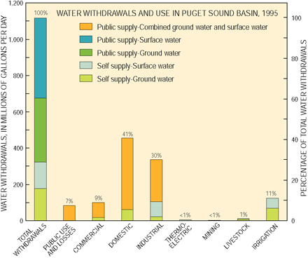 |
||
| Figure 4. Excluding water used for hydroelectric power, 41 percent of water was used for domestic supply in 1995. Ground water accounted for 47 percent of all withdrawals. |
Although surface water provides most of the drinking water for the major urban centers (fig. 4), ground water is used in rural areas, and reliance on ground water as a source of drinking water is increasing with urban and suburban development (Staubitz and others, 1997).
Water availability has been and will continue to be a major, long-term issue in the Puget Sound Basin. It is now widely recognized that ground-water withdrawals can deplete streamflows (Morgan and Jones, 1999), and one of the increasing demands for surface water is the need to maintain instream flows for fish and other aquatic biota.
Hydrologic Conditions Probably Affected Study Results
Surface water was sampled during 1996 and 1997 when rainfall and streamflows generally were above the 30-year average (fig. 5). Because of increased runoff during periods of rainfall, larger amounts of sediment, nutrients, pesticides, bacteria, and other contaminants may have been transported from the land surface into streams and rivers than during drier years. High flows due to runoff from paved surfaces can also alter stream habitat.
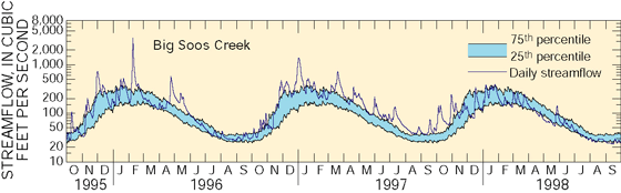 |
||
| Figure 5. Streams and rivers were sampled during 1996 and 1997 when streamflows generally were above the 30-year average. |
Some Ground Water Is Susceptible to Contamination
Shallow ground water (less than 100 feet deep) in the Puget Lowlands is more susceptible to contamination in areas where the overlying sediments are coarse grained than where they are fine grained (see p. 16 and map, p. 20). This is because rainfall, or applied irrigation water, seep relatively easily through coarse-grained sediments and can transport contaminants to ground water.
Study Design Focuses on Land Use
Chemical and biological samples were collected from a mix of rivers and streams in forested, urban, and agricultural areas to assess overall quality as well as the effects of specific land-use practices. At some sites, water samples were collected monthly and during storms to assess the effects of storm runoff on contaminant washoff. Other sites were sampled only once, usually during normal flows.
Shallow ground water was sampled from aquifers in coarse-grained glacial deposits considered to be the most at risk to contamination. Water from these aquifers was sampled to assess general water quality and specifically to assess the quality of water in agricultural and residential areas. Monitoring wells and domestic wells were sampled. Data from a previous sampling of public-supply wells (Ryker and Williamson, 1996) are used to help evaluate the quality of drinking water and the quality of deep ground water. (See table 3, page 21 for details on study design.)
| Table of Contents || Previous Section || Next Section || Glossary U.S. Geological Survey Circular 1216 Suggested citation:
|
