A
Previous Section: Introduction
Next Section: Essential Components of Water-Level Monitoring Programs
Return to Table of Contents
Return to Home Page
This section describes some basic ground-water terms and provides a general description of natural and human factors that affect ground-water levels (heads). It is intended as background information for the reader who may have limited knowledge of ground-water hydrology.
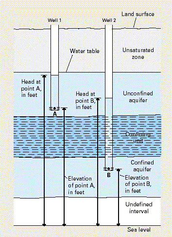
Hydraulic head (often simply referred to as “head”) is an indicator of the total energy available to move ground water through an aquifer. Hydraulic head is measured by the height to which a column of water will stand above a reference elevation (or “datum”), such as mean sea level. A water-level measurement made under static (nonpumping) conditions is a measurement of the hydraulic head in the aquifer at the depth of the screened or open interval of a well (Figure A–1). Because hydraulic head represents the energy of water, ground water flows from locations of higher hydraulic head to locations of lower hydraulic head. The change in hydraulic head over a specified distance in a given direction is called the “hydraulic gradient.”
|
Figure A-1. Sketch showing the relation between hydraulic heads and water levels in two observation wells—Well 1 screened in an unconfined aquifer and Well 2 screened in a confined aquifer. Hydraulic heads in each of these two aquifers are determined by the elevation of the water level in the well relative to a vertical datum—in this case, sea level. |
Two general types of aquifers—unconfined and confined—are recognized (Figure A–2). In unconfined aquifers, hydraulic heads fluctuate freely in response to changes in recharge and discharge. Water levels measured in wells completed in the upper part of an unconfined aquifer help define the elevation of the water table, which is the top of the saturated zone. In confined aquifers, sometimes known as “artesian” aquifers, water in the aquifer is “confined” under pressure by a geological body that is much less permeable than the aquifer itself. Water levels in tightly cased wells completed in confined aquifers often rise above the elevation of the top of the aquifer (Figure A–2). These water levels define an imaginary surface, referred to as the potentiometric surface, which represents the potential height to which water will rise in wells completed in the confined aquifer. Many aquifers are intermediate between being completely unconfined or confined.
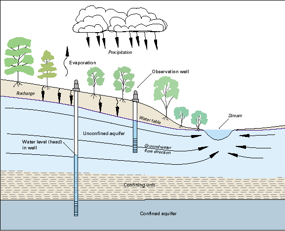 |
| Figure A-2. Cross-section sketch of a typical ground-water-flow system showing the relation between an unconfined and confined aquifer, a water table, and other hydrologic elements. |
Ground-water levels are controlled by the balance among recharge to, storage in, and discharge from an aquifer. Physical properties such as the porosity, permeability, and thickness of the rocks or sediments that compose the aquifer affect this balance. So, too, do climatic and hydrologic factors, such as the timing and amount of recharge provided by precipitation, discharge from the subsurface to surface-water bodies, and evapotranspiration. When the rate of recharge to an aquifer exceeds the rate of discharge, water levels or hydraulic heads will rise. Conversely, when the rate of ground-water withdrawal or discharge is greater than the rate of ground-water recharge, the water stored in the aquifer becomes depleted and water levels or hydraulic heads will decline.
Water levels in many aquifers in the United States follow a natural cyclic pattern of seasonal fluctuation, typically rising during the winter and spring due to greater precipitation and recharge, then declining during the summer and fall owing to less recharge and greater evapotranspiration. The magnitude of fluctuations in water levels can vary greatly from season to season and from year to year in response to varying climatic conditions. Changes in ground-water recharge and storage caused by climatic variability commonly occur over decades, and water levels in aquifers generally have a delayed response to the cumulative effects of drought.
The range and timing of seasonal water-level fluctuations may vary in different aquifers in the same geographic area, depending on the sources of recharge to the aquifers and the physical and hydraulic properties of each. This is illustrated by hydrographs for two wells (GW–11 and MW–1) completed in a layered alluvial aquifer system near the Ohio River in northern Kentucky (Figure A–3). The two wells are approximately 250 feet apart; however, well GW–11 is completed in a shallow aquifer zone consisting of a mixture of silty clay and sand approximately 40 feet thick, while well MW–1 is completed in a deeper aquifer zone consisting of a mixture of sand and gravel approximately 20 feet thick.
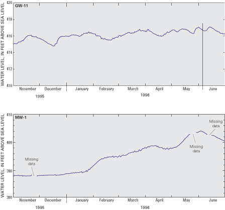 |
| Figure A-3. Example hydrographs showing the difference in timing and range of water-level fluctuations in two observation wells (GW–11 and MW–1) in an alluvial aquifer near the Ohio River, northern Kentucky. |
Because the silty clay does not easily transmit water, the shallow aquifer zone exhibits a relatively muted response to a seasonal increase in recharge that typically occurs at this location during the late winter and spring. As seen on the hydrograph, water levels in well GW–11 fluctuate slightly from November to June in response to individual precipitation events, but exhibit an overall seasonal increase of less than 2 feet. In contrast, the more permeable sand and gravel in the deeper aquifer zone transmits water very easily, and the deeper aquifer zone exhibits a much greater response to the seasonal increase in recharge. On the hydrograph for well MW–1, water levels increase gradually at first from November through January, then more sharply from February to June, and exhibit an overall seasonal increase of more than 12 feet.
Superimposed on natural, climate-related fluctuations in ground-water levels are the effects of human activities that alter the natural rates of ground-water recharge or discharge. For example, urban development, deforestation, and draining of wetlands can expedite surface runoff and thus reduce ground-water recharge. Agricultural tillage, the impoundment of streams, and creation of artificial wetlands can increase ground-water recharge. Long-term water-level monitoring during periods of significant land-use change is important to the protection of aquifers. The effects of such human-induced changes on ground-water recharge and storage are often incremental, and the cumulative effects may not become evident for many years.
The withdrawal of ground water by pumping is the most significant human activity that alters the amount of ground water in storage and the rate of discharge from an aquifer. The removal of water stored in geologic materials near the well sets up hydraulic gradients that induce flow from more distant parts of the aquifer. As ground-water storage is depleted within the radius of influence of pumping, water levels in the aquifer decline. The area of water-level decline is called the cone of depression, and its size is controlled by the rate and duration of pumping, the storage characteristics of the aquifer, and the ease with which water is transmitted through the geologic materials to the well. The development of a cone of depression can result in an overall decline in water levels over a large geographic area, change the direction of ground-water flow within an aquifer, reduce the amount of base flow to streams, and capture water from a stream or from adjacent aquifers. Within areas having a high density of pumped wells, multiple cones of depression can develop within an aquifer.
As the reader examines the case studies discussed in this report, it is instructive to identify the natural and human-induced stresses on the aquifers described and the relative and combined effects of each on ground-water levels. This will illustrate the primary point of emphasis—that ground-water-level data must be collected accurately and over periods of sufficient time to enable the proper development, management, and protection of the Nation’s ground-water resources.
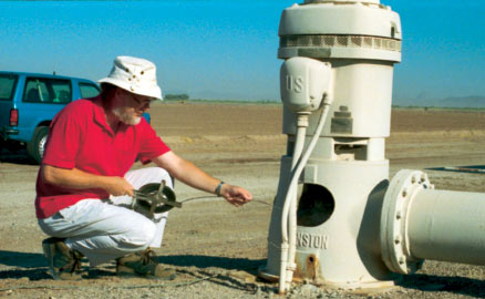 |
| Measuring water level in dewatering well near Yuma, Arizona. Photograph by Sandra J. Owen-Joyce, U.S. Geological Survey. |
[an error occurred while processing this directive]